Freer, Texas
| Freer, Texas | |
|---|---|
| City | |
 Location of Freer, Texas | |
 | |
| Coordinates: 27°52′45″N 98°36′58″W / 27.87917°N 98.61611°WCoordinates: 27°52′45″N 98°36′58″W / 27.87917°N 98.61611°W | |
| Country | United States |
| State | Texas |
| County | Duval |
| Area | |
| • Total | 4.06 sq mi (10.52 km2) |
| • Land | 4.05 sq mi (10.49 km2) |
| • Water | 0.01 sq mi (0.03 km2) |
| Elevation | 518 ft (158 m) |
| Population (2010) | |
| • Total | 2,818 |
| • Density | 696/sq mi (268.7/km2) |
| Time zone | Central (CST) (UTC-6) |
| • Summer (DST) | CDT (UTC-5) |
| ZIP code | 78357 |
| Area code(s) | 361 |
| FIPS code | 48-27432[1] |
| GNIS feature ID | 1336186[2] |
| Website |
www |


Freer is a city in Duval County, Texas, United States. The population was 2,818 at the 2010 census,[3] down from 3,241 at the 2000 census. The city and county are heavily Hispanic in ethnicity and Democratic in voting history. From the 1930s-1960s, the county was dominated by the political boss, called a patron in South Texas, George Parr, a supporter of U.S. President Lyndon B. Johnson. Parr's influence waned thereafter, and he committed suicide at his Los Harcones ranch in 1975.
Like Sweetwater, the seat of Nolan County in West Texas, Freer holds an annual rattlesnake roundup in March.
The first oil well in Texas was drilled in Freer in 1860, a year after the discovery in Titusville, Pennsylvania, but it was unproductive. In 1907, oil was again discovered in Duval County, six years after Spindletop near Beaumont.
Geography
Freer is located in northwestern Duval County at 27°52′45″N 98°36′58″W / 27.87917°N 98.61611°W (27.879156, -98.616237).[4] U.S. Route 59 passes east-west through the city as Riley Street. Once outside the city limits, US 59 leads northeast 68 miles (109 km) to Beeville and southwest 59 miles (95 km) to Laredo. Texas State Highway 16 (Norton Avenue) crosses US 59 in the center of town and leads north 111 miles (179 km) to San Antonio and southwest 92 miles (148 km) to Zapata on the Rio Grande. Texas State Highway 44 passes through the center of Freer on Riley Street with US 59 but leads east 25 miles (40 km) to San Diego, the Duval County seat, and 35 miles (56 km) to Alice, as well as west 47 miles (76 km) to Interstate 35 at Encinal.
According to the United States Census Bureau, Freer has a total area of 4.1 square miles (10.5 km2), of which 0.012 square miles (0.03 km2), or 0.30%, is water.[3]
Demographics
As of the census[1] of 2000, there were 3,241 people, 1,111 households, and 845 families residing in the city. The population density was 804.3 people per square mile (310.5/km²). There were 1,334 housing units at an average density of 331.1 per square mile (127.8/km²). The racial makeup of the city was 80.59% White, 0.46% African American, 0.68% Native American, 0.25% Asian, 14.87% from other races, and 3.15% from two or more races. Hispanic or Latino of any race were 77.38% of the population.
There were 1,111 households out of which 42.0% had children under the age of 18 living with them, 56.3% were married couples living together, 14.3% had a female householder with no husband present, and 23.9% were non-families. 21.5% of all households were made up of individuals and 9.2% had someone living alone who was 65 years of age or older. The average household size was 2.92 and the average family size was 3.40.
In the city the population was spread out with 33.1% under the age of 18, 9.8% from 18 to 24, 26.3% from 25 to 44, 19.9% from 45 to 64, and 10.9% who were 65 years of age or older. The median age was 30 years. For every 100 females there were 95.9 males. For every 100 females age 18 and over, there were 96.2 males.
The median income for a household in the city was $25,078, and the median income for a family was $26,475. Males had a median income of $26,789 versus $17,159 for females. The per capita income for the city was $11,457. About 18.4% of families and 21.6% of the population were below the poverty line, including 26.5% of those under age 18 and 25.4% of those age 65 or over.
| Historical population | |||
|---|---|---|---|
| Census | Pop. | %± | |
| 1940 | 2,346 | — | |
| 1950 | 2,280 | −2.8% | |
| 1960 | 2,734 | 19.9% | |
| 1970 | 2,804 | 2.6% | |
| 1980 | 3,213 | 14.6% | |
| 1990 | 3,271 | 1.8% | |
| 2000 | 3,241 | −0.9% | |
| 2010 | 2,818 | −13.1% | |
| Est. 2015 | 2,732 | [5] | −3.1% |
Education
The city is served by the Freer Independent School District.
Notable people
- Jim Acker, baseball player
- Steve McMichael, UT Longhorn standout and professional football player for the NFL's 1985 Bears
- Paul Sadler, Texas politician, born in Freer in 1955
- Buddy Temple (D), a lumber magnate from Lufkin and former member of the Texas House of Representatives and the Texas Railroad Commission, operated a ranch near Freer[7]
Media
Climate
The climate in this area is characterized by hot, humid summers and generally mild to cool winters. According to the Köppen Climate Classification system, Freer has a humid subtropical climate, abbreviated "Cfa" on climate maps.[9]
References
- 1 2 "American FactFinder". United States Census Bureau. Retrieved 2008-01-31.
- ↑ "US Board on Geographic Names". United States Geological Survey. 2007-10-25. Retrieved 2008-01-31.
- 1 2 "Geographic Identifiers: 2010 Demographic Profile Data (G001): Freer city, Texas". American Factfinder. U.S. Census Bureau. Retrieved January 8, 2016.
- ↑ "US Gazetteer files: 2010, 2000, and 1990". United States Census Bureau. 2011-02-12. Retrieved 2011-04-23.
- ↑ "Annual Estimates of the Resident Population for Incorporated Places: April 1, 2010 to July 1, 2015". Retrieved July 2, 2016.
- ↑ "Census of Population and Housing". Census.gov. Retrieved June 4, 2015.
- ↑ "Advisory Board". ckwri.tamuk.edu. Retrieved May 16, 2012.
- ↑ "KBRA". FindTheData FM Radio Stations. Retrieved 2013-09-14.
- ↑ Climate Summary for Freer, Texas
External links
Municipalities and communities of Duval County, Texas, United States | ||
|---|---|---|
| Cities | 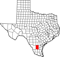 | |
| CDPs | ||
| Unincorporated communities | ||
| Ghost towns | ||
| Footnotes | ‡This populated place also has portions in an adjacent county or counties | |