List of Interstate Highways in Texas
| Dwight D. Eisenhower National System of Interstate and Defense Highways | |
|---|---|
|
Texas Highway markers for Interstate 10, Interstate 820, and Future Interstate 14 | |
|
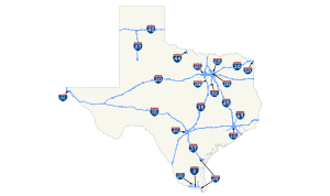
All Interstate Highways in Texas | |
| System information | |
| Maintained by TxDOT | |
| Length: | 3,274.7 mi (5,270.1 km) |
| Formed: | June 29, 1956[1] |
| Highway names | |
| Interstates: |
Interstate X (I-X) Interstate Highway X (IH-X) |
| US Highways: | U.S. Highway X (US X) |
| State: | State Highway X (SH X) |
| Loops: | Loop X |
| Spurs: | Spur X |
| Recreational: | Recreational Road X (RE X) |
| Farm or Ranch to Market Roads: |
Farm to Market Road X (FM X) Ranch to Market Road X (RM X) |
| Park Roads: | Park Road X (PR X) |
| System links | |


.svg.png)
The Interstate Highways in Texas are all owned and maintained by the U.S. state of Texas.[2] The Texas Department of Transportation (TxDOT) is the agency responsible for the day-to-day maintenance and operations of the Interstate Highways in Texas. The Interstate Highway System in Texas covers 3,239.7 miles (5,213.8 km) and consists of eleven primary routes, seven auxiliary routes and Interstate 35 (I-35) which is split into two branches, I-35E and I-35W, that provide access to both Fort Worth and Dallas. The longest segment of Interstate Highway in Texas is I-10 at 878.6 miles (1,414.0 km); the shortest is I-110 at 0.9 miles (1.4 km).
The construction of the Interstate Highway System in Texas began well before these routes were designated as Interstate Highways. A 50-mile (80 km) stretch of I-45 between Galveston and Houston was opened in 1951, eight years before it was designated I-45. It was also the first urban expressway in Texas. In 1962, 43 miles (69 km) of I-35 opened in Bexar County, the first section of Interstate Highway to open from county line to county line in a large metropolitan area.[3] Portions of I-10 west of San Antonio took much longer to complete due to the vast open spaces and lack of nearby labor. The majority of the construction of this section of I-10 occurred in the 1970s and 1980s and was complete by the early 1990s. The section east of San Antonio was completed 20 years earlier in 1972.[4] The opening of a 6-mile (10 km) section of I-27 in 1992 completed the Interstate Highway System in Texas.[5]
Planning is ongoing for a proposed extension of I-69 southward from its current terminus in Indiana through Texas to the United States–Mexico border.[6] If complete as planned, I-69 will extend about 650 miles (1,050 km) across Texas, from the Louisiana state line in the Texarkana–Shreveport area to South Texas.[7] The first 6.2-mile (10.0 km) portion was approved in 2011, with signage posted December 6, 2011.
Primary Interstate Highways
| Number | Length (mi) | Length (km) | Southern or western terminus | Northern or eastern terminus | Formed | Removed | Notes | |
|---|---|---|---|---|---|---|---|---|
| 46.8[8] | 75.3 | US 83 west of Palmview | I-69E/US 77/US 83 in Harlingen | 2013[8] | current | Intersects I-69C in Pharr[9][10][11] | ||
| 877.455[12] | 1,412.127 | I-10/US 85/US 180 at New Mexico state line in Anthony | I-10/US 90 at Louisiana state line in Orange | 1959[12] | current | Intersects I-110 in El Paso;[13] I-20 between Kent and Balmorhea;[14][15] I-35, I-37, and I-410 in San Antonio;[16] and I-45, I-69, and I-610 in Houston[17] | ||
| 700 | 1,130 | I-10 / U.S. Route 190 near Fort Stockton, Texas | I-14 at Louisiana state line | proposed | — | Known as the Fourteenth Amendment Highway; Proposed Interstate highway | ||
| 634.723[18] | 1,021.488 | I-10 between Kent and Toyah | I-20 at Louisiana state line east of Waskom | 1959[18] | current | Intersects I-30, I-35W, and I-820 in Fort Worth;[19] I-35E, I-45, and I-635 in Dallas;[20] and future I-369 in Marshall[21] | ||
| 124.182[22] | 199.852 | US 87/Loop 289 in Lubbock | I‑40/US 60/US 87/US 287 in Amarillo | 1968[22] | current | |||
| 223.404[23] | 359.534 | I-20 in Fort Worth | I-30/US 59/US 71 at Arkansas state line in Texarkana | 1959[23] | current | Intersects I-35W and I-820 in Fort Worth;[19] I-35E, I-45, I-345, and I-635 in Dallas;[20] and I-369 in Texarkana[24] | ||
| 407.195[25] | 655.317 | Fed. 85 at Juárez–Lincoln International Bridge in Laredo I-35E & I-35W in Hillsboro | I-35E & I-35W in Denton I-35/US 77 at Oklahoma state line north of Gainesville |
1959[25] | current | Intersects I-69W in Laredo[26] then I-10, I-37, and I-410 in San Antonio[16][27] before branching at Hillsboro into I-35E and I-35W[28] through Dallas and Fort Worth reuniting in Denton[29] | ||
| 96.657[30] | 155.554 | I-35 & I-35W in Hillsboro | I-35 & I-35W in Denton | 1959[30] | current | Eastern branch of I-35 through Dallas where it intersects I-20, I-30, and I-635[20][31] | ||
| 85.283[32] | 137.250 | I-35 & I-35E in Hillsboro | I-35 & I-35E in Denton | 1959[32] | current | Western branch of I-35 through Fort Worth where it intersects I-20, I-30, and I-820[19] | ||
| 142.787[33] | 229.793 | US 181/SH 35 in Corpus Christi | I-35/US 281 in San Antonio | 1959[33] | current | Intersects I-69E in Corpus Christi;[34] future I-69W east of George West; and both I-10 and I-410 in San Antonio[16][27] | ||
| 177.139[35] | 285.078 | I-40 at New Mexico state line in Glenrio | I-40 at Oklahoma state line east of Shamrock | 1959[35] | current | Intersects I-27 in Amarillo[36] | ||
| 15.398[37] | 24.781 | US 277/US 281/US 287 in Wichita Falls | I-44/US 277/US 281 at Oklahoma state line north of Burkburnett | 1982[37] | current | |||
| 284.913[38] | 458.523 | SH 87 in Galveston | I-30, I-345, US 67 in Dallas | 1959[38] | current | Intersects I-10, I-69, and I-610 in Houston;[17] and I-20 in Dallas[20] | ||
| — | — | I-49/US 59/US 71 at Arkansas state line north of Texarkana | I-49 at Arkansas state line north of Texarkana | proposed | — | Links two Arkansas I-49 segments; it will intersect future I-369 north of Texarkana[39] | ||
| 74.9[40] | 120.5 | US 59 in Rosenberg | US 59 north of Splendora | 2011[40][41] | current | Intersects I-10, I-45, and I-610 in Houston; The future I-69 will extend from I-69E/I-69W merger south of Victoria along US 59 to Tenaha intersecting I-369 before following US 84 to I-69 at Louisiana state line east of Joaquin[42] | ||
| 18[43] | 29 | I-2/US 83/US 281 in Pharr | US 281/FM 2812 in Edinburg | 2013[43] | current | The future I-69C will follow US 281 ending at I-69W in George West[42] | ||
| 61.1[44] | 98.3 | Fed. 101/Fed. 180 at Veterans International Bridge in Brownsville US 77/SH 44 in Robstown | US 77/Bus. US 77 in Raymondville I-37/US 77 in Corpus Christi |
2013[44] | current | Intersects I-169 in Olmito and I-2 in Harlingen; The future I-69E will follow US 77 to I-69/I-69W south of Victoria[42] | ||
| 1.4[45] | 2.3 | Fed. 85D at World Trade International Bridge in Laredo | I-35/US 59/US 83/Loop 20 in Laredo | 2014[45] | current | The future I-69W will follow US 59 to I-69/I-69E south of Victoria intersecting I-69C in George West and I-37 east of George West[42] | ||
| ||||||||
-
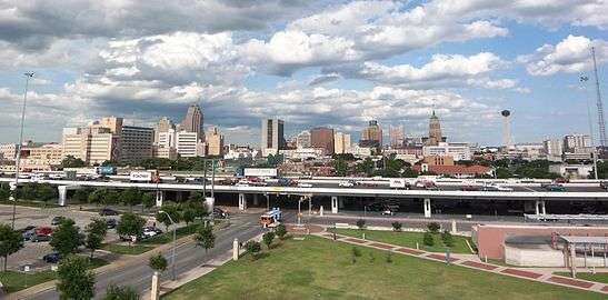
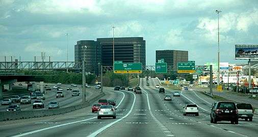
I-10 and I-35 run concurrently as an elevated freeway in Downtown San Antonio
-
I-20 in southern Fort Worth
-
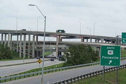
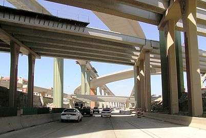
I-37 and I-410 interchange on the southeast side of San Antonio
-

Interchange between I-37 and I-69E/US 77
-
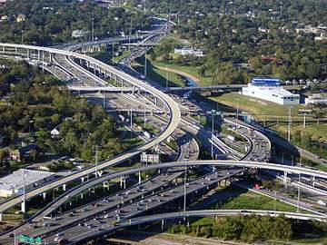
I-10 and I-45 near Downtown Houston
Auxiliary Interstate Highways
| Number | Length (mi) | Length (km) | Southern or western terminus | Northern or eastern terminus | Formed | Removed | Notes |
|---|---|---|---|---|---|---|---|
| 0.891[46] | 1.434 | Fed. 45 at Bridge of the Americas in El Paso | I-10/US 54/US 180 in El Paso | 1967[46] | current | Partially along US 54[13] | |
| — | — | I-69E/US 77/US 83 in Olmito | Port of Brownsville | 2015 | current | Frontage roads opened and signed as SH 550 from I-69E/US 77/US 83 to FM 3248 in 2011 and from FM 3248 to the Port of Brownsville in 2013; main lanes opened and co-signed with SH 550 from I-69E/US 77/US 83 to Old Alice Road in 2015, main lanes currently under construction from Old Alice Road to the Port of Brownsville and should be completed by 2016, it will be a toll route once fully completed | |
| 1.400[47] | 2.253 | I-30/I-45/US 67 in Dallas | US 75/Spur 366 in Dallas | 1964[47] | current | Unsigned | |
| 3.5[48] | 5.6 | US 59/SH 93/Loop 151 in Texarkana | I-30/US 59 in Texarkana | 2013[48] | current | Proposed extension along US 59 to I-69 in Tenaha; intersects I-20 and future I-49[21] | |
| 49.488[49] | 79.643 | Beltway around San Antonio | 1959[49] | current | Intersects I-10, I-35, and I-37[16][27] | ||
| 37.972[50] | 61.110 | Beltway around Houston | 1959[50] | current | Intersects I-10, I-45, and I-69[17] | ||
| 36.999[51] | 59.544 | I-20 in Balch Springs | SH 121 in Grapevine | 1959[51] | current | Partial Dallas beltway; intersects I-30, and I-35E[20][31] | |
| 35.173[52] | 56.605 | I-20 in Fort Worth | I-20/US 287 in Fort Worth | 1959[52] | current | Partial Fort Worth beltway; intersects I-30 and I-35W[19] | |
-
I-610 at US 290 in Houston
-
The High Five Interchange at I-635 and US 75 in Dallas
Business Interstate Highways
| Number | Length (mi)[lower-alpha 1] | Length (km) | Southern or western terminus | Northern or eastern terminus | Formed | Removed | Notes | |
|---|---|---|---|---|---|---|---|---|
| 2.747[53] | 4.421 | I-10 in Sierra Blanca | I-10 in Sierra Blanca | 1990[53] | current | Formerly Loop 416 signed as Bus. US 80[54] | ||
| 2.881[55] | 4.637 | I-10 in Van Horn | I-10 in Van Horn | 1990[55] | current | Formerly Loop 519 signed as Bus. US 80[56] | ||
| 2.000[57] | 3.219 | I-10/FM 2903 north of Balmorhea | I-10/SH 17 east of Balmorhea | 1991[57] | current | Formerly part of US 290 and FM 2903[57] | ||
| 1.398[58] | 2.250 | I-10/US 67 in Fort Stockton | I-10/US 67/US 385 in Fort Stockton | 1991[58] | current | Formerly part of US 290[58] | ||
| 14.042[59] | 22.598 | I-20 west of Pecos | I-20 east of Barstow | 1991[59] | current | Formerly part of US 80[59] | ||
| 8.223[60] | 13.234 | I-20 west of Monahans | I-20 in Monahans | 1991[60] | current | Formerly part of US 80[60] | ||
| 31.761[61] | 51.114 | I-20 in West Odessa | I-20 east of Midland | 1991[61] | current | Formerly part of US 80[61] | ||
| 4.687[62] | 7.543 | I-20 west of Stanton | I-20 east of Stanton | 1995[62] | current | Formerly Loop 214 preceded by US 80[63] | ||
| 5.609[64] | 9.027 | I-20 west of Big Spring | I-20 in Big Spring | 1990[64] | current | Formerly Loop 402 signed as Bus. US 80[65] | ||
| 1.069[66] | 1.720 | I-20/FM 670 west of Westbrook | I-20 in Westbrook | 1990[66] | current | Formerly Loop 333 preceded by US 80[67] | ||
| 5.926[68] | 9.537 | I-20 west of Colorado City | I-20 east of Colorado City | 1990[68] | current | Formerly Loop 377 signed as Bus. US 80[69] | ||
| 1.633[70] | 2.628 | I-20 west of Loraine, Texas | I-20 in Loraine | 1990[70] | current | Formerly Loop 316 preceded by US 80[71] | ||
| 1.644[72] | 2.646 | I-20 west of Roscoe | Bus. US 84/FM 608 in Roscoe | 1990[72] | current | Formerly Loop 237 preceded by US 80[73] | ||
| 6.448[74] | 10.377 | I-20/US 84 west of Sweetwater | I-20/US 84/SH 70 in Sweetwater | 1990[74] | current | Formerly Loop 432 signed as Bus. US 80[75] | ||
| 2.076[76] | 3.341 | I-20/US 84 west of Trent | I-20/US 84 east of Trent | 1990[76] | current | Formerly Loop 319 preceded by US 80[77] | ||
| 2.786[78] | 4.484 | I-20/US 84 west of Merkel, Texas | I-20/US 84/FM 1235 east of Merkel | 1990[78] | current | Formerly Loop 39 preceded by US 80[79] | ||
| 1.661[80] | 2.673 | I-20/US 84 in Tye | I-20/US 84 in Tye | 1990[80] | current | Formerly Loop 320 preceded by US 80[81] | ||
| 8.466[82] | 13.625 | I-20/US 84 in Tye | I-20 in Abilene | 1990[82] | current | Formerly Loop 355 signed as Bus. US 80[83] | ||
| 2.826[84] | 4.548 | I-20/FM 2047 west of Baird | I-20 east of Baird | 1990[84] | current | Formerly Loop 425 preceded by US 80[85] | ||
| 1.168[86] | 1.880 | I-27/US 87 in Hale Center | I-27/US 87 in Hale Center | 2002[86] | current | |||
| 9.282[87] | 14.938 | I-27/US 87 south of Plainview | I-27/US 87 in Plainview | 1990[87] | current | Formerly Loop 445 signed as Bus. US 87[88] | ||
| 3.400[89] | 5.472 | Fed. 85 at Gateway to the Americas International Bridge in Laredo | I-35/US 83 in Laredo | 1991[89] | current | Segment formerly Bus. US 83 and Loop 420 preceded by US 81/US 83[90][91] | ||
| 1.222[92] | 1.967 | I-35 south of Encinal | I-35/SH 44 north of Encinal | 1990[92] | current | Formerly Loop 532 signed as Bus. US 81[93] | ||
| 2.872[94] | 4.622 | I-35 south of Cotulla | I-35 in Cotulla | 1991[94] | current | Formerly part of US 81[94] | ||
| 4.147[95] | 6.674 | I-35 south of Dilley | I-35 north of Dilley | 1991[95] | current | Formerly part of US 81[95] | ||
| 5.449[96] | 8.769 | I-35/FM 1581 in Pearsall | I-35 north of Pearsall | 1991[96] | current | Segment formerly part of US 81[96] | ||
| 4.488[97] | 7.223 | I-35 in New Braunfels | I-35 in New Braunfels | 1991[97] | current | Formerly part of US 81[97] | ||
| 1.461[98] | 2.351 | I-35 in Kyle | I-35 in Kyle | 1990[98] | current | Formerly part of US 81[98] | ||
| 3.648[99] | 5.871 | I-35 in Round Rock | I-35/FM 3406 in Round Rock | 1990[99] | 2013[99] | Formerly Loop 384 signed as Bus. US 81;[100] segment now Spur 379[101] | ||
| 5.1[102] | 8.2 | I-35 in Georgetown | I-35 in Georgetown | 1990[102] | 2006[102] | Formerly Loop 418 signed as Bus. US 81;[103] segments now Spur 26 and Spur 158[102] | ||
| 2.288[104] | 3.682 | I-35W in Alvarado | I-35W in Alvarado | 1990[104] | current | Formerly Loop 392 signed as Bus. US 81[105] | ||
| 1.883[106] | 3.030 | I-35 in Sanger | I-35 in Sanger | 1991[106] | current | Formerly Spur 138; a portion preceded by part of US 77[107] | ||
| 0.779[108] | 1.254 | Historic US 66 at New Mexico state line in Glenrio | I-40 east of Glenrio | 1990[108] | current | Formerly Spur 504; segment preceded by part of US 66[109] | ||
| 2.369[110] | 3.813 | I-40 west of Adrian | I-40 east of Adrian | 1990[110] | current | Formerly Loop 550[111] preceded by part of US 66[112] | ||
| 3.395[113] | 5.464 | I-40 west of Vega | I-40 east of Vega | 1990[113] | current | Formerly Loop 551[114] preceded by part of US 66[115] | ||
| 14.125[116] | 22.732 | I-40 west of Amarillo | I-40 east of Amarillo | 1990[116] | current | Formerly Loop 552 preceded by part of US 66[117] | ||
| 3.533[118] | 5.686 | I-40 west of Groom | I-40 east of Groom | 1990[118] | current | Formerly Loop 554 preceded by part of US 66[119] | ||
| 3.796[120] | 6.109 | I-40 west of McLean | I-40 east of McLean | 1990[120] | current | Formerly Loop 555 preceded by part of US 66[121] | ||
| 2.770[122] | 4.458 | I-40 west of Shamrock | I-40 east of Shamrock | 1993[122] | current | Formerly Loop 556 preceded by part of US 66[123] | ||
| 6.367[124] | 10.247 | I-45 in Corsicana | I-45/US 287 north of Corsicana | 1990[124] | current | Formerly Loop 564 preceded by part of US 75[125] | ||
| 4.512[126] | 7.261 | I-45 in Ennis | I-45 in Ennis | 1990[126] | current | Formerly Loop 563 preceded by part of US 75[127] | ||
| 2.330[128] | 3.750 | I-45 in Palmer | I-45 north of Palmer | 1990[128] | current | Formerly Loop 562 preceded by part of US 75[129] | ||
| 3.367[130] | 5.419 | I-45 south of Ferris | I-45 north of Ferris | 1990[130] | current | Formerly Loop 560 preceded by part of US 75[131] | ||
| ||||||||
-
Bus. I-10-D in Van Horn
-
Bus. I-35-E in Pearsall
See also
 U.S. Roads portal
 Texas portal
Notes
- ↑ Official route lengths do not include segments that run concurrently with other highways of greater hierarchy
References
- ↑ McNichol, Dan (2006). The Roads that Built America. New York: Sterling. p. 106. ISBN 1-4027-3468-9.
- ↑ Staff. "Interstate Frequently Asked Questions". Federal Highway Administration. Retrieved February 25, 2008.
- ↑ Staff. "TxDOT History: 1970 to 1951". Texas Department of Transportation. Retrieved February 25, 2008.
- ↑ Beaumont, Penny; Brinkmann, Rhonda; Ellis, David; Pourteau, Chris; Webb, Brandon V. "From Anywhere to Everywhere: The Development of the Interstate Highway System in Texas" (PDF). Texas Transportation Institute. p. 30. Archived from the original (PDF) on May 6, 2008. Retrieved February 25, 2008.
- ↑ Staff. "TxDOT History: 2000 to 1971". Texas Department of Transportation. Retrieved February 25, 2008.
- ↑ Staff. "I-69/TTC (Northeast Texas to Mexico)". Texas Department of Transportation. Archived from the original on July 20, 2008. Retrieved February 24, 2008.
- ↑ Staff (February 9, 2008). TTC Tier 1 EIS Meeting Handout. Texas Department of Transportation.
- 1 2 Transportation Planning and Programming Division (n.d.). "Interstate Highway No. 2". Highway Designation Files. Texas Department of Transportation. Retrieved December 3, 2014.
- ↑ Transportation Planning and Programming Division (2014). Texas County Map Book (PDF) (Map) (2014 ed.). 1:120,000. Texas Department of Transportation. p. 351. Retrieved December 2, 2014.
- ↑ Transportation Planning and Programming Division (2014). Texas County Map Book (PDF) (Map) (2014 ed.). 1:120,000. Texas Department of Transportation. p. 381. Retrieved December 2, 2014.
- ↑ Transportation Planning and Programming Division (2014). Texas County Map Book (PDF) (Map) (2014 ed.). 1:120,000. Texas Department of Transportation. p. 411. Retrieved December 2, 2014.
- 1 2 Transportation Planning and Programming Division (n.d.). "Interstate Highway No. 10". Highway Designation Files. Texas Department of Transportation. Retrieved December 3, 2014.
- 1 2 Transportation Planning and Programming Division (2014). Texas County Map Book (PDF) (Map) (2014 ed.). 1:120,000. Texas Department of Transportation. p. 6. Retrieved December 2, 2014.
- ↑ Transportation Planning and Programming Division (2014). Texas County Map Book (PDF) (Map) (2014 ed.). 1:120,000. Texas Department of Transportation. p. 30. Retrieved December 2, 2014.
- ↑ Transportation Planning and Programming Division (2014). Texas County Map Book (PDF) (Map) (2014 ed.). 1:120,000. Texas Department of Transportation. p. 40. Retrieved December 2, 2014.
- 1 2 3 4 Transportation Planning and Programming Division (2014). Texas County Map Book (PDF) (Map) (2014 ed.). 1:120,000. Texas Department of Transportation. p. 339. Retrieved December 2, 2014.
- 1 2 3 Transportation Planning and Programming Division (2014). Texas County Map Book (PDF) (Map) (2014 ed.). 1:120,000. Texas Department of Transportation. p. 497. Retrieved December 2, 2014.
- 1 2 Transportation Planning and Programming Division (n.d.). "Interstate Highway No. 20". Highway Designation Files. Texas Department of Transportation. Retrieved December 3, 2014.
- 1 2 3 4 Transportation Planning and Programming Division (2014). Texas County Map Book (PDF) (Map) (2014 ed.). 1:120,000. Texas Department of Transportation. p. 387. Retrieved December 2, 2014.
- 1 2 3 4 5 Transportation Planning and Programming Division (2014). Texas County Map Book (PDF) (Map) (2014 ed.). 1:120,000. Texas Department of Transportation. p. 417. Retrieved December 2, 2014.
- 1 2 Staff (May 30, 2013). "Interstate 69 Comes to Texarkana and the Valley" (Press release). Alliance for I-69 Texas. Retrieved May 31, 2013.
- 1 2 Transportation Planning and Programming Division (n.d.). "Interstate Highway No. 27". Highway Designation Files. Texas Department of Transportation. Retrieved December 3, 2014.
- 1 2 Transportation Planning and Programming Division (n.d.). "Interstate Highway No. 30". Highway Designation Files. Texas Department of Transportation. Retrieved December 3, 2014.
- ↑ Transportation Planning and Programming Division (2014). Texas County Map Book (PDF) (Map) (2014 ed.). 1:120,000. Texas Department of Transportation. p. 521. Retrieved December 2, 2014.
- 1 2 Transportation Planning and Programming Division (n.d.). "Interstate Highway No. 35". Highway Designation Files. Texas Department of Transportation. Retrieved December 3, 2014.
- ↑ Transportation Planning and Programming Division (2014). Texas County Map Book (PDF) (Map) (2014 ed.). 1:120,000. Texas Department of Transportation. p. 287. Retrieved December 2, 2014.
- 1 2 3 Transportation Planning and Programming Division (2014). Texas County Map Book (PDF) (Map) (2014 ed.). 1:120,000. Texas Department of Transportation. p. 340. Retrieved December 2, 2014.
- ↑ Transportation Planning and Programming Division (2014). Texas County Map Book (PDF) (Map) (2014 ed.). 1:120,000. Texas Department of Transportation. p. 420. Retrieved December 2, 2014.
- ↑ Transportation Planning and Programming Division (2014). Texas County Map Book (PDF) (Map) (2014 ed.). 1:120,000. Texas Department of Transportation. p. 385. Retrieved December 2, 2014.
- 1 2 Transportation Planning and Programming Division (n.d.). "Interstate Highway No. 35-E". Highway Designation Files. Texas Department of Transportation. Retrieved December 3, 2014.
- 1 2 Transportation Planning and Programming Division (2014). Texas County Map Book (PDF) (Map) (2014 ed.). 1:120,000. Texas Department of Transportation. p. 416. Retrieved December 2, 2014.
- 1 2 Transportation Planning and Programming Division (n.d.). "Interstate Highway No. 35-W". Highway Designation Files. Texas Department of Transportation. Retrieved December 3, 2014.
- 1 2 Transportation Planning and Programming Division (n.d.). "Interstate Highway No. 37". Highway Designation Files. Texas Department of Transportation. Retrieved December 3, 2014.
- ↑ Transportation Planning and Programming Division (2014). Texas County Map Book (PDF) (Map) (2014 ed.). 1:120,000. Texas Department of Transportation. p. 405. Retrieved December 2, 2014.
- 1 2 Transportation Planning and Programming Division (n.d.). "Interstate Highway No. 40". Highway Designation Files. Texas Department of Transportation. Retrieved December 3, 2014.
- ↑ Transportation Planning and Programming Division (2014). Texas County Map Book (PDF) (Map) (2014 ed.). 1:120,000. Texas Department of Transportation. p. 119. Retrieved December 2, 2014.
- 1 2 Transportation Planning and Programming Division (n.d.). "Interstate Highway No. 44". Highway Designation Files. Texas Department of Transportation. Retrieved December 3, 2014.
- 1 2 Transportation Planning and Programming Division (n.d.). "Interstate Highway No. 45". Highway Designation Files. Texas Department of Transportation. Retrieved December 3, 2014.
- ↑ Planning and Research Division (2012). 2012 Highway Map of Arkansas (PDF) (Map). Scale not given. Little Rock: Arkansas State Highway and Transportation Department. § H2. Retrieved December 3, 2014.
- 1 2 Transportation Planning and Programming Division (n.d.). "Interstate Highway No. 69". Highway Designation Files. Texas Department of Transportation. Retrieved December 3, 2014.
- ↑ Brezosky, Lynn (December 6, 2011). "Coastal Bend, Valley Unveil First Stretch of Interstate 69". San Antonio Express-News. Retrieved December 10, 2011.
- 1 2 3 4 Texas Department of Transportation (March 1, 2013). Status of I-69 Designation in Texas (PDF) (Map). Scale not given. Austin: Texas Department of Transportation. Retrieved December 4, 2014.
- 1 2 Transportation Planning and Programming Division (n.d.). "Interstate Highway No. 69-C". Highway Designation Files. Texas Department of Transportation. Retrieved December 3, 2014.
- 1 2 Transportation Planning and Programming Division (n.d.). "Interstate Highway No. 69-E". Highway Designation Files. Texas Department of Transportation. Retrieved December 3, 2014.
- 1 2 "Minutes of the regular meeting of the Texas Transportation Commission" (PDF). Texas Department of Transportation. June 26, 2014. p. 4. Retrieved December 3, 2014.
- 1 2 Transportation Planning and Programming Division (n.d.). "Interstate Highway No. 110". Highway Designation Files. Texas Department of Transportation. Retrieved December 4, 2014.
- 1 2 Transportation Planning and Programming Division (n.d.). "Interstate Highway No. 345". Highway Designation Files. Texas Department of Transportation. Retrieved December 4, 2014.
- 1 2 Transportation Planning and Programming Division (n.d.). "Interstate Highway No. 369". Highway Designation Files. Texas Department of Transportation. Retrieved December 4, 2014.
- 1 2 Transportation Planning and Programming Division (n.d.). "Interstate Highway No. 410". Highway Designation Files. Texas Department of Transportation. Retrieved December 4, 2014.
- 1 2 Transportation Planning and Programming Division (n.d.). "Interstate Highway No. 610". Highway Designation Files. Texas Department of Transportation. Retrieved December 4, 2014.
- 1 2 Transportation Planning and Programming Division (n.d.). "Interstate Highway No. 635". Highway Designation Files. Texas Department of Transportation. Retrieved December 4, 2014.
- 1 2 Transportation Planning and Programming Division (n.d.). "Interstate Highway No. 820". Highway Designation Files. Texas Department of Transportation. Retrieved December 4, 2014.
- 1 2 Transportation Planning and Programming Division (n.d.). "Business Interstate Highway No. 10-C". Highway Designation Files. Texas Department of Transportation. Retrieved November 26, 2014.
- ↑ Transportation Planning and Programming Division (n.d.). "State Highway Loop No. 416". Highway Designation Files. Texas Department of Transportation. Retrieved November 26, 2014.
- 1 2 Transportation Planning and Programming Division (n.d.). "Business Interstate Highway No. 10-D". Highway Designation Files. Texas Department of Transportation. Retrieved November 26, 2014.
- ↑ Transportation Planning and Programming Division (n.d.). "State Highway Loop No. 519". Highway Designation Files. Texas Department of Transportation. Retrieved November 26, 2014.
- 1 2 3 Transportation Planning and Programming Division (n.d.). "Business Interstate Highway No. 10-F". Highway Designation Files. Texas Department of Transportation. Retrieved November 26, 2014.
- 1 2 3 Transportation Planning and Programming Division (n.d.). "Business Interstate Highway No. 10-G". Highway Designation Files. Texas Department of Transportation. Retrieved November 26, 2014.
- 1 2 3 Transportation Planning and Programming Division (n.d.). "Business Interstate Highway No. 20-B". Highway Designation Files. Texas Department of Transportation. Retrieved November 26, 2014.
- 1 2 3 Transportation Planning and Programming Division (n.d.). "Business Interstate Highway No. 20-D". Highway Designation Files. Texas Department of Transportation. Retrieved November 26, 2014.
- 1 2 3 Transportation Planning and Programming Division (n.d.). "Business Interstate Highway No. 20-E". Highway Designation Files. Texas Department of Transportation. Retrieved November 26, 2014.
- 1 2 Transportation Planning and Programming Division (n.d.). "Business Interstate Highway No. 20-F". Highway Designation Files. Texas Department of Transportation. Retrieved November 26, 2014.
- ↑ Transportation Planning and Programming Division (n.d.). "State Highway Loop No. 214". Highway Designation Files. Texas Department of Transportation. Retrieved November 27, 2014.
- 1 2 Transportation Planning and Programming Division (n.d.). "Business Interstate Highway No. 20-G". Highway Designation Files. Texas Department of Transportation. Retrieved November 26, 2014.
- ↑ Transportation Planning and Programming Division (n.d.). "State Highway Loop No. 402". Highway Designation Files. Texas Department of Transportation. Retrieved November 27, 2014.
- 1 2 Transportation Planning and Programming Division (n.d.). "Business Interstate Highway No. 20-H". Highway Designation Files. Texas Department of Transportation. Retrieved November 27, 2014.
- ↑ Transportation Planning and Programming Division (n.d.). "State Highway Loop No. 333". Highway Designation Files. Texas Department of Transportation. Retrieved November 27, 2014.
- 1 2 Transportation Planning and Programming Division (n.d.). "Business Interstate Highway No. 20-J". Highway Designation Files. Texas Department of Transportation. Retrieved November 27, 2014.
- ↑ Transportation Planning and Programming Division (n.d.). "State Highway Loop No. 377". Highway Designation Files. Texas Department of Transportation. Retrieved November 27, 2014.
- 1 2 Transportation Planning and Programming Division (n.d.). "Business Interstate Highway No. 20-K". Highway Designation Files. Texas Department of Transportation. Retrieved November 27, 2014.
- ↑ Transportation Planning and Programming Division (n.d.). "State Highway Loop No. 316". Highway Designation Files. Texas Department of Transportation. Retrieved November 27, 2014.
- 1 2 Transportation Planning and Programming Division (n.d.). "Business Interstate Highway No. 20-L". Highway Designation Files. Texas Department of Transportation. Retrieved November 27, 2014.
- ↑ Transportation Planning and Programming Division (n.d.). "State Highway Loop No. 237". Highway Designation Files. Texas Department of Transportation. Retrieved November 27, 2014.
- 1 2 Transportation Planning and Programming Division (n.d.). "Business Interstate Highway No. 20-M". Highway Designation Files. Texas Department of Transportation. Retrieved November 27, 2014.
- ↑ Transportation Planning and Programming Division (n.d.). "State Highway Loop No. 432". Highway Designation Files. Texas Department of Transportation. Retrieved November 27, 2014.
- 1 2 Transportation Planning and Programming Division (n.d.). "Business Interstate Highway No. 20-N". Highway Designation Files. Texas Department of Transportation. Retrieved November 27, 2014.
- ↑ Transportation Planning and Programming Division (n.d.). "State Highway Loop No. 319". Highway Designation Files. Texas Department of Transportation. Retrieved November 27, 2014.
- 1 2 Transportation Planning and Programming Division (n.d.). "Business Interstate Highway No. 20-P". Highway Designation Files. Texas Department of Transportation. Retrieved November 27, 2014.
- ↑ Transportation Planning and Programming Division (n.d.). "State Highway Loop No. 39". Highway Designation Files. Texas Department of Transportation. Retrieved November 27, 2014.
- 1 2 Transportation Planning and Programming Division (n.d.). "Business Interstate Highway No. 20-Q". Highway Designation Files. Texas Department of Transportation. Retrieved November 27, 2014.
- ↑ Transportation Planning and Programming Division (n.d.). "State Highway Loop No. 320". Highway Designation Files. Texas Department of Transportation. Retrieved November 27, 2014.
- 1 2 Transportation Planning and Programming Division (n.d.). "Business Interstate Highway No. 20-R". Highway Designation Files. Texas Department of Transportation. Retrieved November 27, 2014.
- ↑ Transportation Planning and Programming Division (n.d.). "State Highway Loop No. 355". Highway Designation Files. Texas Department of Transportation. Retrieved November 27, 2014.
- 1 2 Transportation Planning and Programming Division (n.d.). "Business Interstate Highway No. 20-T". Highway Designation Files. Texas Department of Transportation. Retrieved November 27, 2014.
- ↑ Transportation Planning and Programming Division (n.d.). "State Highway Loop No. 425". Highway Designation Files. Texas Department of Transportation. Retrieved November 27, 2014.
- 1 2 Transportation Planning and Programming Division (n.d.). "Business Interstate Highway No. 27-T". Highway Designation Files. Texas Department of Transportation. Retrieved November 27, 2014.
- 1 2 Transportation Planning and Programming Division (n.d.). "Business Interstate Highway No. 27-U". Highway Designation Files. Texas Department of Transportation. Retrieved November 27, 2014.
- ↑ Transportation Planning and Programming Division (n.d.). "State Highway Loop No. 445". Highway Designation Files. Texas Department of Transportation. Retrieved November 27, 2014.
- 1 2 Transportation Planning and Programming Division (n.d.). "Business Interstate Highway No. 35-A". Highway Designation Files. Texas Department of Transportation. Retrieved November 27, 2014.
- ↑ Transportation Planning and Programming Division (n.d.). "Business U.S. Highway No. 83-K". Highway Designation Files. Texas Department of Transportation. Retrieved November 27, 2014.
- ↑ Transportation Planning and Programming Division (n.d.). "State Highway Loop No. 420". Highway Designation Files. Texas Department of Transportation. Retrieved November 27, 2014.
- 1 2 Transportation Planning and Programming Division (n.d.). "Business Interstate Highway No. 35-B". Highway Designation Files. Texas Department of Transportation. Retrieved November 27, 2014.
- ↑ Transportation Planning and Programming Division (n.d.). "State Highway Loop No. 532". Highway Designation Files. Texas Department of Transportation. Retrieved November 27, 2014.
- 1 2 3 Transportation Planning and Programming Division (n.d.). "Business Interstate Highway No. 35-C". Highway Designation Files. Texas Department of Transportation. Retrieved November 27, 2014.
- 1 2 3 Transportation Planning and Programming Division (n.d.). "Business Interstate Highway No. 35-D". Highway Designation Files. Texas Department of Transportation. Retrieved November 27, 2014.
- 1 2 3 Transportation Planning and Programming Division (n.d.). "Business Interstate Highway No. 35-E". Highway Designation Files. Texas Department of Transportation. Retrieved November 27, 2014.
- 1 2 3 Transportation Planning and Programming Division (n.d.). "Business Interstate Highway No. 35-H". Highway Designation Files. Texas Department of Transportation. Retrieved November 27, 2014.
- 1 2 3 Transportation Planning and Programming Division (n.d.). "Business Interstate Highway No. 35-J". Highway Designation Files. Texas Department of Transportation. Retrieved November 27, 2014.
- 1 2 3 Transportation Planning and Programming Division (n.d.). "Business Interstate Highway No. 35-L". Highway Designation Files. Texas Department of Transportation. Retrieved November 27, 2014.
- ↑ Transportation Planning and Programming Division (n.d.). "State Highway Loop No. 384". Highway Designation Files. Texas Department of Transportation. Retrieved November 27, 2014.
- ↑ Transportation Planning and Programming Division (n.d.). "State Highway Spur No. 379". Highway Designation Files. Texas Department of Transportation. Retrieved November 27, 2014.
- 1 2 3 4 Transportation Planning and Programming Division (n.d.). "Business Interstate Highway No. 35-M". Highway Designation Files. Texas Department of Transportation. Retrieved November 27, 2014.
- ↑ Transportation Planning and Programming Division (n.d.). "State Highway Loop No. 418". Highway Designation Files. Texas Department of Transportation. Retrieved November 27, 2014.
- 1 2 Transportation Planning and Programming Division (n.d.). "Business Interstate Highway No. 35-V". Highway Designation Files. Texas Department of Transportation. Retrieved November 27, 2014.
- ↑ Transportation Planning and Programming Division (n.d.). "State Highway Loop No. 392". Highway Designation Files. Texas Department of Transportation. Retrieved November 27, 2014.
- 1 2 Transportation Planning and Programming Division (n.d.). "Business Interstate Highway No. 35-X". Highway Designation Files. Texas Department of Transportation. Retrieved November 27, 2014.
- ↑ Transportation Planning and Programming Division (n.d.). "State Highway Spur No. 138". Highway Designation Files. Texas Department of Transportation. Retrieved November 27, 2014.
- 1 2 Transportation Planning and Programming Division (n.d.). "Business Interstate Highway No. 40-A". Highway Designation Files. Texas Department of Transportation. Retrieved November 28, 2014.
- ↑ Transportation Planning and Programming Division (n.d.). "State Highway Spur No. 504". Highway Designation Files. Texas Department of Transportation. Retrieved November 28, 2014.
- 1 2 Transportation Planning and Programming Division (n.d.). "Business Interstate Highway No. 40-B". Highway Designation Files. Texas Department of Transportation. Retrieved November 28, 2014.
- ↑ Transportation Planning and Programming Division (n.d.). "State Highway Loop No. 550". Highway Designation Files. Texas Department of Transportation. Retrieved November 28, 2014.
- ↑ Texas State Highway Department (January 1, 1961). General Highway Map, Oldham County, Texas (Map). 1:126,720. Austin: Texas State Highway Department. p. 1. Retrieved December 5, 2014.
- 1 2 Transportation Planning and Programming Division (n.d.). "Business Interstate Highway No. 40-C". Highway Designation Files. Texas Department of Transportation. Retrieved November 28, 2014.
- ↑ Transportation Planning and Programming Division (n.d.). "State Highway Loop No. 551". Highway Designation Files. Texas Department of Transportation. Retrieved November 28, 2014.
- ↑ Texas State Highway Department (January 1, 1961). General Highway Map, Oldham County, Texas (Map). 1:126,720. Austin: Texas State Highway Department. p. 2. Retrieved December 5, 2014.
- 1 2 Transportation Planning and Programming Division (n.d.). "Business Interstate Highway No. 40-D". Highway Designation Files. Texas Department of Transportation. Retrieved November 28, 2014.
- ↑ Transportation Planning and Programming Division (n.d.). "State Highway Loop No. 552". Highway Designation Files. Texas Department of Transportation. Retrieved November 28, 2014.
- 1 2 Transportation Planning and Programming Division (n.d.). "Business Interstate Highway No. 40-F". Highway Designation Files. Texas Department of Transportation. Retrieved November 28, 2014.
- ↑ Transportation Planning and Programming Division (n.d.). "State Highway Loop No. 554". Highway Designation Files. Texas Department of Transportation. Retrieved November 28, 2014.
- 1 2 Transportation Planning and Programming Division (n.d.). "Business Interstate Highway No. 40-H". Highway Designation Files. Texas Department of Transportation. Retrieved November 28, 2014.
- ↑ Transportation Planning and Programming Division (n.d.). "State Highway Loop No. 555". Highway Designation Files. Texas Department of Transportation. Retrieved November 28, 2014.
- 1 2 Transportation Planning and Programming Division (n.d.). "Business Interstate Highway No. 40-J". Highway Designation Files. Texas Department of Transportation. Retrieved November 28, 2014.
- ↑ Transportation Planning and Programming Division (n.d.). "State Highway Loop No. 556". Highway Designation Files. Texas Department of Transportation. Retrieved November 28, 2014.
- 1 2 Transportation Planning and Programming Division (n.d.). "Business Interstate Highway No. 45-F". Highway Designation Files. Texas Department of Transportation. Retrieved November 28, 2014.
- ↑ Transportation Planning and Programming Division (n.d.). "State Highway Loop No. 564". Highway Designation Files. Texas Department of Transportation. Retrieved November 28, 2014.
- 1 2 Transportation Planning and Programming Division (n.d.). "Business Interstate Highway No. 45-G". Highway Designation Files. Texas Department of Transportation. Retrieved November 28, 2014.
- ↑ Transportation Planning and Programming Division (n.d.). "State Highway Loop No. 563". Highway Designation Files. Texas Department of Transportation. Retrieved November 28, 2014.
- 1 2 Transportation Planning and Programming Division (n.d.). "Business Interstate Highway No. 45-H". Highway Designation Files. Texas Department of Transportation. Retrieved November 28, 2014.
- ↑ Transportation Planning and Programming Division (n.d.). "State Highway Loop No. 562". Highway Designation Files. Texas Department of Transportation. Retrieved November 28, 2014.
- 1 2 Transportation Planning and Programming Division (n.d.). "Business Interstate Highway No. 45-J". Highway Designation Files. Texas Department of Transportation. Retrieved November 28, 2014.
- ↑ Transportation Planning and Programming Division (n.d.). "State Highway Loop No. 560". Highway Designation Files. Texas Department of Transportation. Retrieved November 28, 2014.
External links