Breckenridge, Texas
| Breckenridge, Texas | |
|---|---|
| City | |
|
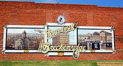
Mural in downtown Breckenridge | |
 Location of Breckenridge, Texas | |
 | |
| Coordinates: 32°45′24″N 98°54′20″W / 32.75667°N 98.90556°WCoordinates: 32°45′24″N 98°54′20″W / 32.75667°N 98.90556°W | |
| Country | United States |
| State | Texas |
| County | Stephens |
| Area | |
| • Total | 4.2 sq mi (10.8 km2) |
| • Land | 4.2 sq mi (10.8 km2) |
| • Water | 0.0 sq mi (0.0 km2) |
| Elevation | 1,204 ft (367 m) |
| Population (2000) | |
| • Total | 5,868 |
| • Density | 1,412.8/sq mi (545.5/km2) |
| Time zone | Central (CST) (UTC-6) |
| • Summer (DST) | CDT (UTC-5) |
| ZIP code | 76424 |
| Area code(s) | 254 |
| FIPS code | 48-10132[1] |
| GNIS feature ID | 1372709[2] |
Breckenridge is a city in Stephens County, Texas, United States. The population was 5,780 at the 2010 census. It is the county seat of Stephens County.[3] The mayor is Jim McKay.
Breckenridge was a stop on the since defunct Wichita Falls and Southern Railroad, one of the properties of Frank Kell and Joseph A. Kemp of Wichita Falls, Texas. The line was thereafter operated until 1969 by the Chicago, Rock Island and Pacific Railroad.[4]
Former Texas State Representative Carl Isett of Lubbock (District 84) was born in Breckenridge in 1957.
Dallas Cowboys legend and Texas High School Football Hall of Fame member Gerald M. "Jerry" Tubbs was an honor graduate student and played center at Breckenridge High School. He was part of two Texas state championship football teams in 1951 and 1952. He played in three high school All-Star games and was a unanimous Texas All-State selection in 1952. In 1971, Tubbs was inducted into the Texas High School Football Hall of Fame. Since 2008, the Breckenridge Buckaroos open the football season playing the "Jerry Tubbs Kickoff Classic".
April 2008 tornado
At approximately 5:20 PM local time on April 9, 2008, three tornadoes, including a pair of "sisters", were confirmed to have hit at least a portion of the town . Fifteen citizens were reported injured within the city limits. Five buildings were destroyed, including the airport, which was a former Air Force training facility.
Geography
Breckenridge is located at 32°45′24″N 98°54′20″W / 32.75667°N 98.90556°W (32.756793, -98.905580).[5]
According to the United States Census Bureau, the city has a total area of 4.2 square miles (10.8 km²), of which, 4.2 square miles (10.7 km²) of it is land and 0.24% is water.
Demographics
| Historical population | |||
|---|---|---|---|
| Census | Pop. | %± | |
| 1880 | 497 | — | |
| 1890 | 462 | −7.0% | |
| 1920 | 1,846 | — | |
| 1930 | 7,569 | 310.0% | |
| 1940 | 5,826 | −23.0% | |
| 1950 | 6,610 | 13.5% | |
| 1960 | 6,273 | −5.1% | |
| 1970 | 5,944 | −5.2% | |
| 1980 | 6,921 | 16.4% | |
| 1990 | 5,665 | −18.1% | |
| 2000 | 5,868 | 3.6% | |
| 2010 | 5,780 | −1.5% | |
| Est. 2015 | 5,590 | [6] | −3.3% |
As of the census[1] of 2000, there were 5,868 people, 2,274 households, and 1,546 families residing in the city. The population density was 1,412.8 people per square mile (545.9/km²). There were 2,776 housing units at an average density of 668.4 per square mile (258.3/km²). The racial makeup of the city was 83.88% White, .01% African American, 0.34% Native American, 0.46% Asian, 0.03% Pacific Islander, 11.28% from other races, and 1.76% from two or more races. Hispanic or Latino of any race were 20.64% of the population.
There were 2,274 households out of which 36.5% had children under the age of 18 living with them, 51.1% were married couples living together, 12.6% had a female householder with no husband present, and 32.0% were non-families. 29.2% of all households were made up of individuals and 14.8% had someone living alone who was 65 years of age or older. The average household size was 2.55 and the average family size was 3.16.
In the city the population was spread out with 30.2% under the age of 18, 8.5% from 18 to 24, 26.0% from 25 to 44, 20.0% from 45 to 64, and 15.3% who were 65 years of age or older. The median age was 34 years. For every 100 females there were 89.7 males. For every 100 females age 18 and over, there were 84.3 males.
The median income for a household in the city was $28,697, and the median income for a family was $35,164. Males had a median income of $25,923 versus $20,467 for females. The per capita income for the city was $14,014. About 16.9% of families and 19.3% of the population were below the poverty line, including 26.9% of those under age 18 and 14.4% of those age 65 or over.
Education

The City of Breckenridge is served by the Breckenridge Independent School District.
Breckenridge High School's mascot is a Buckaroo (a cowboy riding a bucking horse). The Junior High School's mascot is a Bronco. The school colors are green and white. The Breckenridge High School football team of 1958 was voted the Ft. Worth Star Telegram team of the century. The Buckaroos have appeared in six Class 3A State Football Championships, winning four times in 1951, 1952, 1954, and 1958 with ties in 1929 and 1959. Breckenridge High School has also produced girls tennis state champions, girls golf state champions, FFA and 4-H state and national champions, and academic state champions over the past decade.
In 2011, the U.S. Department of Education recognized Breckenridge Junior High School as a National Blue Ribbon School.
Breckenridge is also the home of a West Texas campus of the Texas State Technical College System. Environmental Science Technology, Construction Management Technology, Computer Aided Drafting and Design, Digital Imaging and Design, Software and Business Accounting, Associate Degree Nursing, Chemical Dependency Counseling, and Health Information Technology are some of the courses offered at the Breckenridge TSTC campus. TSTC partners with BHS and other Texas high schools to offer dual credit courses.
History

Breckenridge was a major oil producer in the early 1920s. The population jumped from a thousand to fifty thousand in under five years. Briefly the home of western legend/dentist/gambler John "Doc" Holliday.
Climate
The climate in this area is characterized by hot, humid summers and generally mild to cool winters. According to the Köppen Climate Classification system, Breckenridge has a humid subtropical climate, abbreviated "Cfa" on climate maps.[8]
References
- 1 2 "American FactFinder". United States Census Bureau. Archived from the original on 2013-09-11. Retrieved 2008-01-31.
- ↑ "US Board on Geographic Names". United States Geological Survey. 2007-10-25. Retrieved 2008-01-31.
- ↑ "Find a County". National Association of Counties. Archived from the original on 2011-06-15. Retrieved 2011-06-07.
- ↑ "H. Allen Anderson, "Wichita Falls and Southern Railroad"". tshaonline.org. Retrieved April 19, 2013.
- ↑ "US Gazetteer files: 2010, 2000, and 1990". United States Census Bureau. 2011-02-12. Retrieved 2011-04-23.
- ↑ "Annual Estimates of the Resident Population for Incorporated Places: April 1, 2010 to July 1, 2015". Retrieved July 2, 2016.
- ↑ "Census of Population and Housing". Census.gov. Archived from the original on May 11, 2015. Retrieved June 4, 2015.
- ↑ Climate Summary for Breckenridge, Texas
External links
| Wikimedia Commons has media related to Breckenridge, Texas. |
- City of Breckenridge Chamber of Commerce Website
- http://www.breckenridgetx.gov/ City of Breckenridge Official Website
Municipalities and communities of Stephens County, Texas, United States | ||
|---|---|---|
| City |  | |
| Unincorporated community | ||
| Ghost town | ||
