Sutherland Shire
| Sutherland Shire New South Wales | |||||||||||||
|---|---|---|---|---|---|---|---|---|---|---|---|---|---|
 Location in Metropolitan Sydney | |||||||||||||
| Coordinates | 34°02′S 151°03′E / 34.033°S 151.050°ECoordinates: 34°02′S 151°03′E / 34.033°S 151.050°E | ||||||||||||
| Population | 226,220 (2015)[1] (14th) | ||||||||||||
| • Density | 629.4/km2 (1,630/sq mi) | ||||||||||||
| Area | 370 km2 (142.9 sq mi) | ||||||||||||
| Mayor | Carmello Pesce | ||||||||||||
| Council seat | Sutherland | ||||||||||||
| Region | Metropolitan Sydney | ||||||||||||
| State electorate(s) | |||||||||||||
| Federal Division(s) | |||||||||||||
|
| |||||||||||||
| Website | Sutherland Shire | ||||||||||||
| |||||||||||||
The Sutherland Shire is a local government area in the southern region of Sydney, in the state of New South Wales, Australia.
Geographically, it is the area to the south of Botany Bay and the Georges River. The administrative centre of the local government is located in the suburb of Sutherland, with council chambers located in Eton Street. Within the Shire is the birthplace of modern Australia, as it was the first landing site of Captain James Cook, who went ashore onto what is now the suburb of Kurnell on 29 April 1770. It was originally intended to be the site of the first British Settlement, before Sydney Cove was chosen as the location during the First Fleet.[2] The Sutherland Shire is 26 kilometres (16 mi) south of Sydney central business district, and is bordered by Bankstown, Wollongong, Liverpool, Hurstville and Campbelltown local government areas.
With a population of 210,863 as at the 2011 census, Sutherland Shire was the second most populous local government area in New South Wales (behind Blacktown), and the eighth largest overall in Australia.
The Sutherland Shire is colloquially known as "The Shire" and it has been featured in several reality television series.
As of the 28 of September 2015 the Mayor of the Sutherland Shire is Cr. Carmello Pesce, a member of the Liberal Party of Australia.
Suburbs and localities in the local government area
Suburbs in the Sutherland Shire are:
- Alfords Point
- Bangor
- Barden Ridge
- Bonnet Bay
- Bundeena
- Burraneer
- Caringbah
- Caringbah South
- Como
- Cronulla
- Dolans Bay
- Engadine
- Grays Point
- Greenhills Beach
- Gymea
- Gymea Bay
- Heathcote
- Illawong
- Jannali
- Kangaroo Point
- Kareela
- Kirrawee
- Kurnell
- Lilli Pilli
- Loftus
- Lucas Heights
- Maianbar
- Menai
- Miranda
- Oyster Bay
- Port Hacking
- Sandy Point
- Sutherland
- Sylvania
- Sylvania Waters
- Taren Point
- Waterfall
- Woolooware
- Woronora
- Woronora Heights
- Yarrawarrah
- Yowie Bay
Localities administered by the Sutherland Shire are:
Demographics


At the 2011 census, there were 210,863 people in the Sutherland local government area, of these 48.9 per cent were male and 51.1 per cent were female. Aboriginal and Torres Strait Islander people made up 0.8 per cent of the population, compared with the state and national averages of 2.5 per cent. The median age of people in the Sutherland Shire area was 39 years. Children aged 0 – 14 years made up 19.1 per cent of the population and people aged 65 years and over made up 14.9 per cent of the population. Of people in the area aged 15 years and over, 53.9 per cent were married and 9.9 per cent were either divorced or separated.[3]
Population growth in the Sutherland Shire area between the 2001 census and the 2006 census was 1.63 per cent and in the subsequent five years to the 2011 census, population growth was 2.64 per cent. When compared with total population growth of Australia for the same periods, being 5.78 per cent and 8.32 per cent respectively, population growth in the Sutherland local government area was significantly lower than the national average.[4][5] The median weekly income for residents within the Sutherland Shire area was higher than the national average.
At the 2011 census, the proportion of residents in the Sutherland local government area who stated their ancestry as Australian or Anglo-Saxon exceeded 72 per cent of all residents (national average was 65.2 per cent). More than 65 per cent of all residents in the Sutherland Shire area nominated a religious affiliation with Christianity (including Eastern Orthodoxy) in the 2011 Census, which was significantly higher than the national average of 50.2 per cent. However, 16.1 per cent of people in the Sutherland Shire stated that they had no religion in the 2011 Census. Meanwhile, as at the census date, compared to the national average, households in the Sutherland local government area had a lower than average proportion (14.7 per cent) where two or more languages are spoken (national average was 20.4 per cent); and a higher proportion (85.2 per cent) where English only was spoken at home (national average was 76.8 per cent).[3][5]
The Shire has a reputation for insular localism that also manifests itself in surf culture. It has a high conservative vote and is Sydney's second largest bible belt.[6]
| Selected historical census data for Sutherland local government area | |||||
|---|---|---|---|---|---|
| Census year | 2001[4] | 2006[5] | 2011[3] | ||
| Population | Estimated residents on Census night | 202,158 | 205,448 | 210,863 | |
| LGA rank in terms of size within New South Wales | 2nd | 7th | |||
| % of New South Wales population | 3.05% | ||||
| % of Australian population | 1.08% | ||||
| Cultural and language diversity | |||||
| Ancestry, top responses | Australian | 28.9% | |||
| English | 28.0% | ||||
| Irish | 9.0% | ||||
| Scottish | 6.6% | ||||
| Italian | 3.0% | ||||
| Language, top responses (other than English) | Greek | 1.9% | |||
| Arabic | 1.0% | ||||
| Cantonese | 1.0% | ||||
| Italian | 1.1% | ||||
| Mandarin | n/c | ||||
| Religious affiliation | |||||
| Religious affiliation, top responses | Catholic | 30.5% | |||
| Anglican | 28.7% | ||||
| No religion | 10.8% | ||||
| Eastern Orthodox | 3.6% | ||||
| Uniting Church | 5.9% | ||||
| Median weekly incomes | |||||
| Personal income | Median weekly personal income | A$601 | A$718 | ||
| % of Australian median income | 129.0% | 124.4% | |||
| Family income | Median weekly family income | A$1,374 | A$2,014 | ||
| % of Australian median income | 133.8% | 136.0% | |||
| Household income | Median weekly household income | A$1,650 | A$1,674 | ||
| % of Australian median income | 140.9% | 135.7% | |||
Council

Current composition and election method
Sutherland Shire Council is composed of fifteen Councillors elected proportionally as five separate wards, each electing three Councillors. All Councillors are elected for a fixed four-year term of office. The Mayor is elected by the Councillors at the first meeting of the Council. The most recent election was held on 10 September 2016,and the makeup of the Council is as follows:[7]
| Party | Councillors | |
|---|---|---|
| Liberal Party of Australia | 7 | |
| Australian Labor Party | 7 | |
| Independent | 1 | |
| Total | 15 | |
The current Council, elected in 2016, in order of election by ward, is:[7]
| Ward | Councillor | Party | Notes | ||
|---|---|---|---|---|---|
| A Ward | Carol Provan | Liberal | |||
| Michael Forshaw | Labor | ||||
| Marie Simone | Liberal | ||||
| B Ward | Kent Johns | Liberal | |||
| Barry Collier | Labor | ||||
| Jack Boyd | Labor | ||||
| C Ward | Tom Croucher | Liberal | |||
| Ray Plibersek | Labor | ||||
| Daniel Nicholls | Liberal | ||||
| D Ward | Carmello Pesce | Liberal | Mayor as of 28 September 2015 | ||
| Deidree Steinwall | Labor | ||||
| Greg McLean | Labor | ||||
| E Ward | John Riad | Liberal | |||
| Steve Simpson | Independent | ||||
| Peter Scaysbrook | Labor | Deputy Mayor as of 26 September 2016 | |||
History
Aboriginal heritage
The original inhabitants of the Sutherland area were some clans of the Dharawal people. Archaeological work in the Sutherland Shire has revealed evidence for Aboriginal settlement dating back at least 8,500 years. The original coastline around Sydney has retreated about 20 km and that those flooded coastal plains may hold evidence showing occupation of this area going back well beyond the 8,500 years revealed in the 1966 Archaeological exploration.[8]
Within the Royal National Park, field surveys have revealed many hundreds of Aboriginal rock shelters. In other locations (The Military Area near Holsworthy and Darkes Forrest) there are thousands of sites, camping areas and sacred places. These areas mentioned have not been affected greatly by European occupation and building and may give a clearer example for the quality of life and abundance of resources in Sutherland/Liverpool areas.
Since 1966 when there was an Archaeological dig in Cabbage Tree Basin archaeologists have uncovered parts of an extensive open-air midden or cooking and camp sites. Successive layers of habitation show the diet of the native Aborigines - oysters, mussels, snapper, bream, and Sydney cockle. There is also evidence of seal, dolphin, a range of marsupials, dingo and even whale. Several edge-ground axes have also found.
There are many existing sites where paintings and engravings of great age show changes in art style over thousands of years. Some of these changes can be linked to the extinction of some animals in the area and also with the coming of Europeans to Sutherland. Some have interpreted these changes in style to changes in culture and people which would indicate that there have been a number of changes of communities over time.[9]
European settlement
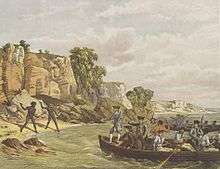
European discovery of what is now Sutherland Shire was made by Lieutenant James Cook, who entered Botany Bay on 29 April 1770. Cook and his party explored around Kurnell Peninsula, and left the bay on 6 May. During their brief stay, a Scottish seaman named Forbes Sutherland died of tuberculosis. In his honour, Cook named the northwest point of the peninsula Point Sutherland.[10]
The British government needed a new site for transported convicts as they had lost their American colonies following defeat in the American Revolutionary War. Botany Bay was chosen as the new penal settlement and the First Fleet under Governor Arthur Phillip anchored off Kurnell on 18 January 1788. After sending a party to clear land for settlement, Phillip soon realised the area was unsuitable. There was lack of shelter for ships, inadequate water and poor soil. On 24 January, two French ships were sighted off the coast, causing Phillip to raise English colours near Sutherland Point. Governor Phillip sailed north to explore Port Jackson, and eventually settled at Sydney Cove.
The first landowner in Sutherland Shire was James Birnie, a mercantile trader who was granted by promise 700 acres (280 ha) at Kurnell in 1815.[11] After the completion of official surveying, a large part of what is now Sutherland Shire was proclaimed as the Hundred of Woronora by Governor Richard Bourke in 1835. Title to land was not granted by the Crown until 1856, before which there was practically no settlement. Timber cutting was the primary industry, supplemented by shell gathering in the Port Hacking area.
With the opening of Crown Lands sales in the Shire, Thomas Holt purchased 12,000 acres (4,900 ha). His developmental projects included oyster farms,[12] cattle grazing, and coal mining.[11] The investment which proved profitable however, were his timber leases. He constructed a magnificent manor on the foreshores of Sylvania, called Sutherland House, based on English feudal lines.[13]
Development of transport

The main mode of transport in the area was originally by water. Farmers' ships sailed up the coast into Botany Bay, and up the Georges and Woronora rivers, avoiding the wharfage and custom dues at Port Jackson. The first public road, the Illawarra Road (now called the Old Illawarra Road) to the "Five Islands" (now Wollongong), was constructed between 1842 and 1845 with convict labour. A new southern line of road was completed in 1864, linking up with the Illawarra Road at Engadine. Today this virtually is the line of the Princes Highway, the main north-south thoroughfare through Sutherland Shire.
A railway line was extended from Hurstville in 1884 to develop the rich Illawarra district. The railway brought into being firstly a huge shanty town on the heights of Como, and later developed the area into a holiday centre. Sutherland railway station was opened in 1885, named after John Sutherland, a Minister of Works during the 1870s who had argued most forcefully for the railway.
At this time, the greater part of the Shire was connected only by access tracks. A road soon opened between the railway station and Cronulla Beach, catering mostly to families and fishing parties. This was followed by the Sutherland-Cronulla steam tram service, which was inaugurated in 1911. Not only did the service greatly increase the popularity of the Cronulla beaches, but it was of great advantage to the slowly developing business interests in the Shire.
Increasing motor traffic caused a falling-off of passengers and the tram passenger service closed in 1931. The goods service ceased the following year. Increased road traffic with the north led to the opening of the first road bridge into the Sutherland Shire, at Tom Ugly's Point, in 1929. The six-lane Captain Cook Bridge over the Georges River, spanning Rocky Point and Taren Point, was opened in 1965, replacing the completely inadequate ferry service.[14]

Residential development

Coastal and river frontage areas, such as Como, Illawong, Cronulla, Illawarra and Yowie Bay, became popular as country retreats. A form of voluntary local government was attempted in 1888, but law and order was still administered by the court at Liverpool until 1905. In that year, the Local Government (Shires) Act 1905 (NSW) provided that the whole of New South Wales be divided into shires. The State Governor, Harry Rawson selected the name, and proclaimed this district "Sutherland, No. 133" on 6 March 1906 and fixed the boundaries. At the time the Shire had 1600 residents, and it was divided into three Ridings.
With only a small rates base, one of the early problems of the Council was the provision of new roads. The construction of the Sutherland-Cronulla tramway by the Railway Commissioner went far in stimulating business activity and driving land sales. The population of the Shire increased from 2,896 in 1911, when the tramway opened, to over 7,500 in 1913. By 1931 the population had exceeded 12,000. It was not until the early 1950s that this district of scattered dwellings, vacant blocks and quiet villages became a suburban area of Sydney. Until this time Sutherland Shire was not considered part of Sydney.
Associated with this growth of population was industrial and commercial development. The Captain Cook Drive from Caringbah to Kurnell was constructed in 1953 in conjunction with the establishment in 1956 of the Australian Oil Refinery at Kurnell. At Lucas Heights, the Australian Atomic Energy Commission (now the Australian Nuclear Science and Technology Organisation) built its research station complex in 1958.
In terms of residential development, one of the most imaginative homebuilding concepts has been Sylvania Waters. Here, individually designed family homes have been built around a series of man-made canals. The urban release of land in the Menai district, to the west of the Woronora River, commenced in the 1970s.[14]
Contemporary Sutherland Shire

As of 2011's census, Sutherland Shire is the second most populous local government area in New South Wales, and 8th in Australia overall.[3]
In December 2005, following incidents on Shire beaches culminating in an assault on a lifeguard by youth of Lebanese descent, an anonymous text message, publicised by major media outlets in Australia, called on people to gather at Cronulla beach on the following Sunday and attack "wogs and lebs". On 11 December 2005 and the days that followed, a series of riots and retaliatory attacks broke out in Cronulla and other beach-side suburbs in Sydney's east which saw numerous assaults. There were two non-fatal stabbings and property damage, especially to motor vehicles. There were many people arrested, over one hundred charged, and extensive national and international media interest.[15][16][17]
Geography

Under the 1853 proclamation, the western boundary of district was the Woronora River. With the formation of the Sutherland Shire in 1906, the western boundary was extended to take in more agricultural land in an area which is now modern day Menai. In 1919, the Illawong area was also transferred to Sutherland Shire. The Shire now has an area of 370 square kilometres (140 sq mi), of which 173 square kilometres (67 sq mi) is state-designated national parkland.
The northern border of the Shire can be crossed via four bridges: three road bridges (Alfords Point, Sylvania Waters and Taren Point) and one railway bridge (Como). To the west, the Heathcote Road leading out of the Shire passes by the Holsworthy military reserve. To the south, the Princes Highway runs out of Waterfall towards the city of Wollongong. The eastern border is bounded by the Tasman Sea.
On the east the Shire has a varying landscape of rugged sea cliffs and sandy beaches, and swampy bay coasts backed by sand dunes. To the west the surface consists of a broad plateau rising gently to the southwest, and cut into by several deep river gorges.[18]
Geology

The geology of the Sutherland Shire, whilst sharing characteristics with the North Shore, is very different from the western and central suburbs of Sydney. The oldest rock unit in the Shire is the Illawarra Coal Measures, exposed from drilling at Helensburgh where it is 305 metres (1,001 ft) below sea level. Above the coal-bearing rocks is found the Narrabeen Group, mostly made up of layers of sandstone and characteristic red claystone beds. Overlying the Narrabeen Group is the Hawkesbury Sandstone, the rock unit most characteristic of the Shire. Occasional patches of Ashfield shale overlay the Hawkesbury sandstone. Some time later than the Triassic period - possibly early Tertiary - minor volcanic activity occurred in the region. This took the form of intrusion of a number of dykes of basaltic rock which forced their way up through the sedimentary rocks. Due to the wetting and drying action of the weather the basaltic rock of the dykes has changed to clay.
From the end of the Triassic period to the middle of the Tertiary period, soft material was worn down or removed by wind and running water. In the final stages of this period of erosion the climate was apparently rather wetter and more humid than today's, causing the exposed rocks to change and form laterite soil, which is abundant in the Shire.
River system

A little later in the Tertiary, tilting occurred south of the Georges River. The slow uplift, taking perhaps several million years, formed the present Woronora Plateau, a surface which rises gently in the south. This process caused the river system in the Shire to flow in steeper watercourses. They then became more active, carving the steep gorges of Woronora, Hacking, Georges Rivers and their tributaries which can be seen today. Waterfalls such as those at Waterfall and Undola also formed during this period. Water supplies within the shire are of two kinds. The main source is the surface supply provided by the Woronora Dam, which is built in the deep gorge of Woronora River. A second source exists in the form of underground water.
During the last ice age, the rivers had to do additional work cutting down through the rocks to reach the lower and more distant ocean, leading to the "valley-in-valley" shape of many of the deep gorges in the Shire. When sea levels rose again, the silt and sand carried by the rivers gradually built up a considerable thickness of sediment. Sediment filled the area between Kurnell (then an island) and Miranda. Sand dunes began to accumulate in the Kurnell area and the mud and sand flats of Quibray and Gunnamatta Bays began to form. The Kurnell sand dunes have provided a cheap source of sand for the southern suburbs of Sydney but in the process of exploitation this area has been robbed of its character and the removal of vegetation has opened the way to erosion.
Royal National Park
The Premier John Robertson dedicated 18,000 acres (7,300 ha) to "The National Park" (now the Royal National Park), gazetted in 1879, making it the second oldest park of its kind in the world after Yellowstone National Park in America (although there is no public gazette record for Yellowstone until sometime in the 1880s), making a valid claim for The Royal National Park being the oldest in the world. In 1880 the Park was increased to 33,000 acres (13,000 ha). Today it is just under 44,000 acres (18,000 ha). The National Park was given the prefix "Royal" after Queen Elizabeth visited the park in 1954.
Urban Structure
The Sutherland Shire is predominantly a residential area but also has substantial industrial, commercial and rural areas. The major commercial areas of the Shire are located in the suburbs of Sutherland, Miranda (home to a large Westfield shopping centre, traditionally known as Miranda Fair), Cronulla, Caringbah, Menai and Engadine. Sutherland Shire's old mantra was:
- Sutherland: "The centre of business".
- Miranda: "The centre of shopping"
- Cronulla: "The centre of leisure"
The Sutherland Shire also includes the suburb of Kurnell, close to the first landing site of James Cook, Sydney's oil refinery and Towra Point Nature Reserve, a wetland of international importance. The Sutherland Shire is also where Australia's first and only nuclear facility is based, at Lucas Heights. The reactor, run by the Australian Nuclear Science and Technology Organisation (ANSTO) does not produce electricity but is used for the production of radiopharmaceuticals, for research and irradiation.
The isolated bayside suburbs of Bundeena and Maianbar are situated between the northern edge of the Royal National Park and Port Hacking. They are only accessible through the park or by the ferry from Cronulla.
Significant Parks and Reserves
- Caravan Head Bushland Reserve
- Royal National Park
- Towra Point Nature Reserve
- Joseph Banks Native Plants Reserve, Kareela
Facilities


Education
There are now nearly 100 schools in the Shire including the Gymea and Loftus Colleges of Technical and Further Education, a technology high school (Gymea Technology High School), one of the ten academically selective high schools in New South Wales (Caringbah High School), more than twenty secondary schools, preschool centres, and special schools provided to serve children with specific learning needs.
Health
The Sutherland Hospital and Kareena Private Hospital are both located at Caringbah and President Private Hospital is located in Kirrawee.
Transport
The Sutherland Shire is serviced by Transdev NSW bus services and Sydney Trains services on the Illawarra line.
Surf life saving
There are four surf life saving clubs and one offshore rescue boat located at Cronulla. The clubs and boat provide life saving and first aid services to the many visitors to the Shire's beaches. The four surf clubs from south to north are: Cronulla SLSC, North Cronulla SLSC, Elouera SLSC and Wanda SLSC. The offshore rescue boat operated by the Cronulla District Lifesaver Rescue frequently assists in major marine rescues along the Sydney coast.
Emergency services
Due to the large area designated as National Park and the previlence of bushland in the area the Sutherland Shire has 12 New South Wales Rural Fire Service stations. There are stations located at Bundeena, Engadine, Grays Point, Heathcote, Illawong, Kurnell, Loftus, Maianbar, Menai (currently relocating to Barden Ridge), Sandy Point, Waterfall and Woronora. These brigades attend fires, vehicle accidents, missing persons searches and community education days. Good coverage in the area from Fire and Rescue NSW also means that these Rural Fire Service members are regularly sent out of area to help the rest of New South Wales and on occasion interstate.
The Sutherland Shire also has one State Emergency Service unit that shares a facility with the Rural Fire Service station at Heathcote.
Culture
- The National Rugby League football club, the Cronulla Sharks are the major local professional sports team. They have an average attendance of 12,000-15,000.
- North Cronulla Surf Life Saving club doubled as a police station in the television series White Collar Blue.
- The Sutherland Sharks Football Club Official website is the Shires New South Wales Premier League 1 Team.
- Sutherland Shire Football Association Official website is the largest Football Association in the Southern Hemisphere
- Four winners of the worlds biggest triathlon, the Ironman World Championships in Kailua-Kona Hawaii, call the Sutherland Shire home. Greg Welch (1994), Michellie Jones (2006), Chris McCormack (2007 & 2010) and Craig Alexander (2008, 2009 & 2011). A resident of the Sutherland Shire won the race,considered the worlds toughest one day sporting event, for six years running (2006-2011).
- The 1979 novel, Puberty Blues by Gabrielle Carey and Kathy Lette, is a teen novel about the lives of two girls from the lower middle class of the Sutherland Shire.
- The 1981 film Puberty Blues and the 2012 TV series Puberty Blues are based on the novel and predominantly filmed around the Sutherland Shire, including Cronulla Beach and the southern campus of Caringbah High School.
- The television reality shows Sylvania Waters and The Shire follow the lives of residents in the Sutherland Shire.
Economy
Retail
Miranda is the retail and commercial centre of the Shire, being home to Westfield Miranda along with two other shopping centres, Kiora Mall and Parkside Plaza. Westfield Miranda, known locally as Miranda Fair, has several department stores and many specialist stores, and was once the largest shopping centre in the Southern Hemisphere. In 2005, the company claimed that the centre was the fourth largest shopping centre in Sydney.[19]
Southgate is another major shopping complex, located in Sylvania and consisting of a number of supermarkets, a K-Mart and various specialty stores. Cronulla is also a popular retail and commercial centre, with numerous restaurants and cafes and a considerable number of surf stores and other clothing and fashion shops.
Other neighbourhood shopping centres have also developed at Caringbah, Bangor, Illawong, Kareela, Jannali, Yarrawarrah and Menai together with a small centre at Alfords Point. Gymea Shopping Village attracts many people, with a regional arts centre, Hazelhurst Regional Gallery and Arts Centre, and a cafe and restaurant scene.
Sister cities
Sutherland Shire maintains sister city relations with the following cities:[20]
There are also two informal relationships:
 Sutherland, Scotland, UK
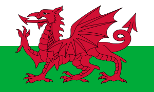 Bangor, Wales, UK
See also
References
- ↑ "3218.0 – Regional Population Growth, Australia, 2014–15". Australian Bureau of Statistics. Retrieved 29 September 2016.
- ↑ https://web.archive.org/web/20091011193947/http://www.sutherland.nsw.gov.au/ssc/home.nsf/Web+Pages/968960D9346BADD3CA256D56001BAC2A?OpenDocument. Archived from the original on 11 October 2009. Retrieved 15 July 2010. Missing or empty
|title=(help) - 1 2 3 4 Australian Bureau of Statistics (31 October 2012). "Sutherland Shire (A)". 2011 Census QuickStats. Retrieved 8 December 2012.
- 1 2 Australian Bureau of Statistics (9 March 2006). "Sutherland Shire (A)". 2001 Census QuickStats. Retrieved 8 December 2012.
- 1 2 3 Australian Bureau of Statistics (25 October 2007). "Sutherland Shire (A)". 2006 Census QuickStats. Retrieved 8 December 2012.
- ↑ Redmond, Anthony (2007). "Surfies Versus Westies: Kinship, Mateship and Sexuality in the Cronulla Riots". The Australian Journal of Anthropology. Proquest. 18 (3): 336–351. doi:10.1111/j.1835-9310.2007.tb00100.x.
- 1 2 "Declaration of the poll". 2012 Local government election results. Sutherland Shire Council. 2012. Retrieved 22 September 2012.
- ↑ https://web.archive.org/web/20090915190212/http://www.sutherland.nsw.gov.au/ssc/home.nsf/AllDocs/RWPD7F788C8EBBED143CA2575F500013BC6?OpenDocument. Archived from the original on 15 September 2009. Retrieved 23 August 2010. Missing or empty
|title=(help) - ↑ http://www.ssrguides.org/about.php?sub=areahistory History of the Sutherland Shire - Sutherland Shire Region Guides
- ↑ (PDF) https://web.archive.org/web/20090913083423/http://www.sutherland.nsw.gov.au/ssc/rwpattach.nsf/viewasattachmentPersonal/FactSheet_5_FINAL_20041020.pdf/$file/FactSheet_5_FINAL_20041020.pdf. Archived from the original (PDF) on 13 September 2009. Retrieved 12 July 2010. Missing or empty
|title=(help) - 1 2 (PDF) https://web.archive.org/web/20090915185453/http://www.sutherland.nsw.gov.au/ssc/rwpattach.nsf/viewasattachmentPersonal/Old+Study+1+scanned.pdf/$file/Old+Study+1+scanned.pdf. Archived from the original (PDF) on 15 September 2009. Retrieved 12 July 2010. Missing or empty
|title=(help) - ↑ Towra Point Nature Reserve
- ↑ Pollon, Frances, ed. (1990). The Book of Sydney Suburbs. Australia: Angus & Robertson Publishers. ISBN 0-207-14495-8.
- 1 2 "webpage name tba". Sutherland Shire Council.
- ↑ "Strike Force Neil, Cronulla Riots, Review of the Police Response Media Component Volume 1 of 4" (PDF-19.4 MB). Retrieved 11 December 2015.
- ↑ "Strike Force Neil, Cronulla Riots, Review of the Police Response Media Component Volume 2 of 4" (PDF-16.9 MB). Retrieved 11 December 2015.
- ↑ "Strike Force Neil, Cronulla Riots, Review of the Police Response Media Component Volume 3 of 4" (PDF-18.8 MB). Retrieved 11 December 2015.
- ↑ http://www.ssrguides.org/about.php?sub=map Location of the Sutherland Shire - Sutherland Shire Region Guides
- ↑ "Annual Report" (PDF). Westfield Holdings Limited. 2005.
- ↑ "Sister Cities". About the Shire. Sutherland Shire Council. Retrieved 22 September 2012.
External links
| Wikimedia Commons has media related to Sutherland Shire. |
| Wikivoyage has a travel guide for Sutherland Shire. |
- Sutherland Shire Council
- Sutherland Shire Info
- Sutherland Shire Environment Centre
- Sutherland Shire Guide - Get On Up
- Shirestream - Online Website for the Community
- Children's Book Council of Australia (CBCA), Sutherland Sub branch - literacy in children and young adults of the Sutherland Shire