Mid-Coast Council
| Mid–Coast Council New South Wales | |||||||||||||
|---|---|---|---|---|---|---|---|---|---|---|---|---|---|
 Mid-Coast Council in New South Wales | |||||||||||||
| Coordinates | 32°00′S 151°58′E / 32.000°S 151.967°ECoordinates: 32°00′S 151°58′E / 32.000°S 151.967°E | ||||||||||||
| Population | 90,504 (2016)[1] | ||||||||||||
| • Density | 9.0027/km2 (23.3168/sq mi) | ||||||||||||
| Established | 12 May 2016[1] | ||||||||||||
| Area | 10,053 km2 (3,881.5 sq mi)[1] | ||||||||||||
| Administrator | John Turner | ||||||||||||
| Region |
Mid North Coast Hunter Region | ||||||||||||
| State electorate(s) | |||||||||||||
| Federal Division(s) | |||||||||||||
|
| |||||||||||||
| Website | Mid–Coast Council | ||||||||||||
| |||||||||||||
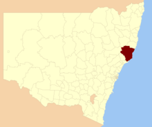
Mid–Coast Council is a local government area located in the Mid North Coast region of New South Wales, Australia. The council was formed on 12 May 2016 through a merger of the Gloucester Shire, Great Lakes and City of Greater Taree councils.[1]
The council comprises an area of 10,053 square kilometres (3,881 sq mi) and occupies the Mid North Coast region between Newcastle-Port Stephens and Port Macquarie. At the time of its establishment the council had an estimated population of 90,504.[1]
The Administrator of the Mid–Coast Council is John Turner, until the elections for councillors to take place on 9 September 2017.[1]
Towns and localities
The following towns and localities are located within Mid–Coast Council:
- Alderley
- Alderley Creek
- Allworth
- Barrington
- Bennetts Head
- Blueys Beach
- Bombah Point
- Boolambayte
- Boomerang Beach
- Booral
- Booti Booti
- Bobin
- Bohnock
- Brinawa
- Burrell Creek
- Bulahdelah
- Bulby Brush
- Bundabah
- Bungwahl
- Bunyah
- Bunyah Upper
- Burgess Beach
- Burraduc
- Cape Hawke
- Carrington
- Charlottes Bay
- Cedar Party
- Coopernook
- Coralville
- Croki
- Crowdy Head
- Cundletown
- Clareval
- Coolongolook
- Coomba
- Coomba Bay
- Coomba Park
- Copeland
- Craven
- Crawford River
- Cureeki Creek
- Darawank
- Diamond Beach
- Dumaresq Island
- Dyers Crossing
- Dewrang
- Dirty Creek
- Dungog
- Elands
- Elizabeth Beach
- Failford
- Fernhill
- Forster
- Forster Keys
- Forster Waters
- Friendship Key
- Gereeba Island
- Girvan
- Ghinni Ghinni
- Glenwarrin
- Gloucester
- Green Point
- Hawks Nest
- Hallidays Point
- Hannam Vale
- Harrington
- Johnsons Creek
- Johns River
- Jones Island
- Karuah
- Kippaxs
- Kolodong
- Koorainghat
- Krambach
- Legges Camp
- Langley Vale
- Lansdowne
- Lime Kiln
- Limeburners Creek
- Markwell
- Mayers Flat
- Milbrook
- Manning Point
- Marlee
- Mitchells Island
- Mooral Creek
- Moorland
- Mount George
- Mill Creek Upper
- Minimbah
- Monkerai
- Mungo Brush
- Myall Lakes
- Myall Upper
- Nabiac
- Nerong
- New Forster
- Newells Creek
- Nooroo
- North Arm Cove
- North Pindimar
- Nugra
- Nugramudgee
- Old Bar
- Oxley Island
- Pacific Palms
- Pampoolah
- Possum Brush
- Purfleet
- Pindimar
- Pioneer Park
- Pipers Bay
- Rawson River
- Rocks Crossing
- Rosenthal
- Sandbar
- Seal Rocks
- Smiths Lake
- South Pindimar
- Stewarts River
- Stratford
- Stroud
- Stroud Road
- Sugarloaf Point
- Tahlee
- Tamboy
- Tarbuck Bay
- Taree
- Tea Gardens
- Telegherry
- Terreel
- The Branch
- Tinonee
- Tiona
- Topi Topi
- Tuncurry
- Upper Karuah River
- Upper Monkerai
- Violet Hill
- Wallamba Island
- Wallingat
- Wallingat River
- Wallis Island
- Wallis Lake
- Waitui
- Wallabi Point
- Wang Wauk
- Wards River
- Warranulla
- Washpool
- Wattley Hill
- Weismantels
- Wherrol Flat
- Whoota
- Willina
- Winda Woppa
- Wingham
- Wootton
- Yagon
- Yagon Beach
Demographics
The population for the predecessor councils was estimated in 2015 as:[2]
- 5,160 in Gloucester Shire
- 36,720 in Great Lakes Council and
- 49,095 in City of Greater Taree.
Council
Once elected, the Mid–Coast Council will comprise eleven Councillors elected proportionally in a single ward. All Councillors are expected to be elected for a fixed four-year term of office with effect from 9 September 2017.[1]
See also
References
- 1 2 3 4 5 6 7 "Mid-Coast Council". Stronger Councils. Government of New South Wales. 12 May 2016. Retrieved 24 May 2016.
- ↑ "Regional Population Growth, Australia. Population Estimates by Local Government Area (ASGS 2015), 2005 to 2015 Table 1. Estimated Resident Population, Local Government Areas, New South Wales". 30 March 2016. Retrieved 21 May 2016.