Port Stephens Council
| Port Stephens Council New South Wales | |||||||||||||
|---|---|---|---|---|---|---|---|---|---|---|---|---|---|
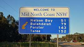 Although entirely geographically in the Hunter Region, Port Stephens is also considered to be part of the Mid North Coast as demonstrated by this sign, only 900 m (2,953 ft) north of the Hunter River. | |||||||||||||
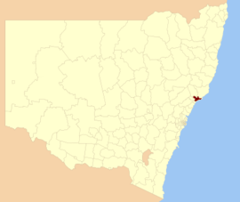 Location in New South Wales | |||||||||||||
| Coordinates | 32°45′S 151°55′E / 32.750°S 151.917°ECoordinates: 32°45′S 151°55′E / 32.750°S 151.917°E | ||||||||||||
| Population | 70,447 (2015 Est.)[1] | ||||||||||||
| • Density | 71.95/km2 (186.3/sq mi) | ||||||||||||
| Area | 979 km2 (378.0 sq mi)[2] | ||||||||||||
| Time zone | AEST (UTC+10) | ||||||||||||
| • Summer (DST) | AEDT (UTC+11) | ||||||||||||
| Mayor | Bruce MacKenzie[3] | ||||||||||||
| Location | |||||||||||||
| Council seat | Raymond Terrace | ||||||||||||
| Region | Hunter,[4] Mid North Coast | ||||||||||||
| State electorate(s) | |||||||||||||
| Federal Division(s) | |||||||||||||
|
| |||||||||||||
| Website | Port Stephens Council | ||||||||||||
| |||||||||||||
Port Stephens Council is a local government area in the Hunter Region of New South Wales, Australia. The area is just north of Newcastle and is adjacent to the Pacific Highway which runs through Raymond Terrace, the largest town and Council seat. The area is named after Port Stephens, which is the major geographical feature of the area. It extends generally from the Hunter River in the south, to near Clarence Town in the north, and from the Tasman Sea in the east, to just south of Paterson in the west. The Mayor of the Port Stephens Council is Bruce MacKenzie.[3]
Main towns and villages
Most of the population is concentrated in Raymond Terrace and its satellite suburb of Heatherbrae or around or near the shores of Port Stephens in the suburbs of Anna Bay, Boat Harbour, Corlette, Fingal Bay, Fishermans Bay, Karuah, Lemon Tree Passage, Mallabula, Nelson Bay, One Mile, Oyster Cove, Salamander Bay, Shoal Bay, Soldiers Point, Swan Bay, Tanilba Bay and Taylors Beach. However, another significant portion of the population lives in a large rural/semi-rural area to the west of the Pacific Highway in the towns and suburbs of Balickera, Butterwick, Duns Creek, Eagleton, East Seaham, Glen Oak, Hinton, Nelsons Plains, Osterley, Seaham, Wallalong and Woodville and in the predominantly residential estate of Brandy Hill.
In the southern part of the area are the rural communities of Bobs Farm, Fern Bay, Fullerton Cove, Salt Ash, Tomago and Williamtown. Tomago supports both rural and industrial communities while Williamtown is the location for a Royal Australian Air Force base that shares its airfield with Newcastle Airport.
At the northern end of the area are Karuah and Twelve Mile Creek. Located adjacent to Port Stephens and straddling the Karuah River, Karuah is predominantly residential. It is the location of the largest Aboriginal community in the area. Twelve Mile Creek is almost exclusively rural.
Centrally located in the area, between Raymond Terrace and Port Stephens are Campvale, Ferodale and Medowie. Ferodale is dominated by Grahamstown Dam, a man-made dam with a capacity of 131,800 megalitres (4,650×106 cu ft) that is a major source of fresh water in the region.[9] The remainder of this area is a mix of rural, semi-rural and residential developments.
A map of the various towns, suburbs and localities within the Port Stephens Council area is available from the Port Stephens Council website.[10]
Demographics
At the 2011 census, there were 64,807 people in the Port Stephens local government area, of these 49.2 per cent were male and 50.8 per cent were female. Aboriginal and Torres Strait Islander people made up 3.6 per cent of the population, which was higher than the national and state averages of 2.5 per cent. The median age of people in the Port Stephens Council area was 42 years, which was significantly higher than the national median of 37 years. Children aged 0 – 14 years made up 19.5 per cent of the population and people aged 65 years and over made up 19.3 per cent of the population. Of people in the area aged 15 years and over, 52.0 per cent were married and 13.5 per cent were either divorced or separated.[11]
Population growth in the Port Stephens Council area between the 2001 census and the 2006 census was 7.10 per cent; and in the subsequent five years to the 2011 census, population growth was 7.15 per cent. When compared with total population growth of Australia for the same periods, being 5.78 per cent and 8.32 per cent respectively, population growth in the Port Stephens local government area was approximately equal to the national average.[12][13] The median weekly income for residents within the Port Stephens Council area was significantly lower than the national average.[11]
At the 2011 census, the proportion of residents in the Port Stephens local government area who stated their ancestry as Australian or Anglo-Saxon exceeded 81 per cent of all residents (national average was 65.2 per cent). In excess of 63% of all residents in the Port Stephens Council nominated a religious affiliation with Christianity at the 2011 census, which was significantly higher than the national average of 50.2 per cent. Meanwhile, as at the census date, compared to the national average, households in the Port Stephens local government area had a significantly lower than average proportion (4.6 per cent) where two or more languages are spoken (national average was 20.4 per cent); and a significantly higher proportion (92.2 per cent) where English only was spoken at home (national average was 76.8 per cent).[11]
| Selected historical census data for the Port Stephens Council local government area | |||||
|---|---|---|---|---|---|
| Census year | 2001[12] | 2006[13] | 2011[11] | ||
| Population | Estimated residents on Census night | 56,474 | 60,484 | 64,807 | |
| LGA rank in terms of size within New South Wales | |||||
| % of New South Wales population | 0.94% | ||||
| % of Australian population | 0.30% | ||||
| Cultural and language diversity | |||||
| Ancestry, top responses | Australian | 33.3% | |||
| English | 32.5% | ||||
| Irish | 8.0% | ||||
| Scottish | 7.5% | ||||
| German | 3.1% | ||||
| Language, top responses (other than English) | Italian | 0.2% | |||
| German | 0.3% | ||||
| Greek | 0.2% | ||||
| Croatian | 0.2% | ||||
| French | n/c | ||||
| Religious affiliation | |||||
| Religious affiliation, top responses | Anglican | 32.5% | |||
| Catholic | 24.2% | ||||
| No Religion | 11.9% | ||||
| Uniting Church | 8.0% | ||||
| Presbyterian and Reformed | 4.5% | ||||
| Median weekly incomes | |||||
| Personal income | Median weekly personal income | A$388 | A$498 | ||
| % of Australian median income | 83.3% | ||||
| Family income | Median weekly family income | A$1,029 | A$1,245 | ||
| % of Australian median income | 87.9% | ||||
| Household income | Median weekly household income | A$830 | A$999 | ||
| % of Australian median income | 80.8% | ||||
Council
Current composition and election method
Port Stephens Council is composed of ten Councillors, including the Mayor, for a fixed four-year term of office. The Mayor is directly elected while the nine other Councillors are elected proportionally as three separate wards, each electing three Councillors. The most recent election was held on 8 September 2012, and the makeup of the Council, including the Mayor, is as follows:[3][14]
| Party | Councillors | |
|---|---|---|
| Independents and Unaligned | 10 | |
| Total | 10 | |
The current Council, elected in 2012, in order of election by ward, is:
| Ward | Councillor | Party | Notes | |
|---|---|---|---|---|
| Mayor[3] | Bruce McKenzie | Independent | ||
| East Ward[14] | John Nell | Independent | ||
| Sally Dover | Independent | |||
| John Morello | Independent | |||
| Central Ward[14] | Chris Doohan | Independent | ||
| Geoff Dingle | Independent | |||
| Steve Tucker | Independent | |||
| West Ward[14] | Ken Jordan | Independent | ||
| Paul Le Mottee | Independent | |||
| Peter Kafer | Independent | |||
Proposed merger with Newcastle
A 2015 review of local government boundaries by the NSW Government Independent Pricing and Regulatory Tribunal recommended the merger of a number of adjoining councils. In the initial proposal, Port Stephens Council was not included in any amalgamation proposals. However, after Lake Macquarie City Council successfully avoided a proposed merger between it and Newcastle City Council,[15] the Minister for Local Government subsequently proposed that Newcastle City Council instead merge with Port Stephens Council to form a new council with an area of 1,045 km2 (403 sq mi) and support a population of approximately 230,000.[16][17]
The proposed merger has been met with significant opposition. Thousands of residents have attended rallies and signed petitions opposed to the proposal,[18] while 470 have attended public inquiry meetings.[19][20] The state member for Port Stephens, Kate Washington, former state member Craig Baumann and broadcaster Alan Jones have all publicly expressed their opposition.[18][20][21] Federal Liberal member for Paterson, Bob Baldwin, spoke in parliament, urging the Liberal Baird government to reconsider the proposal, claiming "this proposal seems to defy logic".[22][23] Port Stephens Council claims that 93% of residents surveyed were opposed to the merger, and included the results of its community survey in its submission to the delegate responsible for evaluating the merge.[19][24] In response to the government's proposal, Port Stephens Council has formally asked the government to evaluate a merger between Port Stephens and Dungog Shire.[19][25][26] Although the Dungog Shire mayor is opposed to this merger, it is reported that the proposal has community support within both local government areas.[26][27] The proposal was debated in the New South Wales parliament on 23 March 2016, with the Minister for Local Government confirming that the proposal had been referred to the Office of Local Government.[28][29]
Climate
Port Stephens Council covers an area of 979 square kilometres (378 sq mi), stretching approximately 57 kilometres (35 mi) from east to west and approximately 30 km (19 mi) from north to south, and experiences various climatic conditions throughout the LGA.[2][10] These are monitored by five weather stations, four of which are located at the approximate cardinal points of the area, operated by the Bureau of Meteorology. The fifth station is located on RAAF Base Williamtown. The following tables indicate average climatic data throughout the area.
Eastern
| Climate data for Nelson Head, Nelson Bay | |||||||||||||
|---|---|---|---|---|---|---|---|---|---|---|---|---|---|
| Month | Jan | Feb | Mar | Apr | May | Jun | Jul | Aug | Sep | Oct | Nov | Dec | Year |
| Record high °C (°F) | 36.5 (97.7) |
41.5 (106.7) |
36.0 (96.8) |
30.5 (86.9) |
26.7 (80.1) |
24.0 (75.2) |
24.4 (75.9) |
27.4 (81.3) |
34.2 (93.6) |
33.9 (93) |
40.6 (105.1) |
39.3 (102.7) |
41.5 (106.7) |
| Average high °C (°F) | 27.3 (81.1) |
27.1 (80.8) |
25.9 (78.6) |
23.7 (74.7) |
20.8 (69.4) |
18.4 (65.1) |
17.5 (63.5) |
18.9 (66) |
21.4 (70.5) |
23.3 (73.9) |
24.8 (76.6) |
26.3 (79.3) |
22.95 (73.29) |
| Average low °C (°F) | 18.2 (64.8) |
18.4 (65.1) |
17.0 (62.6) |
14.6 (58.3) |
11.7 (53.1) |
9.4 (48.9) |
8.4 (47.1) |
9.3 (48.7) |
11.2 (52.2) |
13.5 (56.3) |
15.2 (59.4) |
17.1 (62.8) |
13.67 (56.61) |
| Record low °C (°F) | 11.0 (51.8) |
14.5 (58.1) |
11.5 (52.7) |
9.0 (48.2) |
6.1 (43) |
4.4 (39.9) |
2.2 (36) |
1.1 (34) |
5.0 (41) |
8.5 (47.3) |
6.7 (44.1) |
9.0 (48.2) |
1.1 (34) |
| Average rainfall mm (inches) | 100.8 (3.969) |
111.3 (4.382) |
119.2 (4.693) |
126.7 (4.988) |
152.2 (5.992) |
153.1 (6.028) |
141.1 (5.555) |
105.5 (4.154) |
88.8 (3.496) |
78.3 (3.083) |
78.8 (3.102) |
95.0 (3.74) |
1,350.8 (53.182) |
| Source: [30] | |||||||||||||
North
| Climate data for Wallaroo State Forest, Twelve Mile Creek | |||||||||||||
|---|---|---|---|---|---|---|---|---|---|---|---|---|---|
| Month | Jan | Feb | Mar | Apr | May | Jun | Jul | Aug | Sep | Oct | Nov | Dec | Year |
| Average high °C (°F) | 28.3 (82.9) |
27.8 (82) |
26.5 (79.7) |
23.0 (73.4) |
19.8 (67.6) |
17.1 (62.8) |
16.4 (61.5) |
18.0 (64.4) |
21.2 (70.2) |
23.7 (74.7) |
26.2 (79.2) |
28.0 (82.4) |
23 (73.4) |
| Average low °C (°F) | 16.3 (61.3) |
16.4 (61.5) |
14.8 (58.6) |
11.0 (51.8) |
7.4 (45.3) |
5.8 (42.4) |
3.6 (38.5) |
4.8 (40.6) |
6.7 (44.1) |
10.2 (50.4) |
12.4 (54.3) |
14.6 (58.3) |
10.33 (50.59) |
| Average rainfall mm (inches) | 124.8 (4.913) |
121.7 (4.791) |
142.6 (5.614) |
100.0 (3.937) |
99.7 (3.925) |
118.7 (4.673) |
63.4 (2.496) |
68.1 (2.681) |
58.2 (2.291) |
79.7 (3.138) |
83.0 (3.268) |
90.6 (3.567) |
1,150.5 (45.294) |
| Source: [31] | |||||||||||||
South-central
| Climate data for RAAF Base Williamtown, Williamtown | |||||||||||||
|---|---|---|---|---|---|---|---|---|---|---|---|---|---|
| Month | Jan | Feb | Mar | Apr | May | Jun | Jul | Aug | Sep | Oct | Nov | Dec | Year |
| Record high °C (°F) | 44.4 (111.9) |
42.8 (109) |
40.7 (105.3) |
37.0 (98.6) |
29.6 (85.3) |
26.6 (79.9) |
27.8 (82) |
30.1 (86.2) |
36.0 (96.8) |
39.4 (102.9) |
43.2 (109.8) |
42.8 (109) |
44.4 (111.9) |
| Average high °C (°F) | 27.9 (82.2) |
27.5 (81.5) |
26.2 (79.2) |
23.7 (74.7) |
20.2 (68.4) |
17.6 (63.7) |
17.0 (62.6) |
18.6 (65.5) |
21.2 (70.2) |
23.6 (74.5) |
25.4 (77.7) |
27.2 (81) |
23.01 (73.43) |
| Average low °C (°F) | 18.0 (64.4) |
18.1 (64.6) |
16.3 (61.3) |
13.2 (55.8) |
10.1 (50.2) |
7.8 (46) |
6.4 (43.5) |
6.9 (44.4) |
9.0 (48.2) |
12.0 (53.6) |
14.2 (57.6) |
16.5 (61.7) |
12.38 (54.28) |
| Record low °C (°F) | 9.4 (48.9) |
9.6 (49.3) |
8.6 (47.5) |
2.1 (35.8) |
−0.6 (30.9) |
0.0 (32) |
−3.9 (25) |
−1.9 (28.6) |
0.4 (32.7) |
3.0 (37.4) |
5.1 (41.2) |
7.9 (46.2) |
−3.9 (25) |
| Average rainfall mm (inches) | 99.9 (3.933) |
121.4 (4.78) |
121.7 (4.791) |
104.2 (4.102) |
115.0 (4.528) |
121.0 (4.764) |
71.6 (2.819) |
78.1 (3.075) |
59.4 (2.339) |
74.5 (2.933) |
80.9 (3.185) |
80.0 (3.15) |
1,127.7 (44.399) |
| Source: [32] | |||||||||||||
Western
| Climate data for Tocal Automatic Weather Station (AWS), Tocal | |||||||||||||
|---|---|---|---|---|---|---|---|---|---|---|---|---|---|
| Month | Jan | Feb | Mar | Apr | May | Jun | Jul | Aug | Sep | Oct | Nov | Dec | Year |
| Record high °C (°F) | 43.7 (110.7) |
44.6 (112.3) |
41.2 (106.2) |
37.3 (99.1) |
29.5 (85.1) |
26.1 (79) |
27.3 (81.1) |
30.4 (86.7) |
36.2 (97.2) |
40.1 (104.2) |
42.5 (108.5) |
44.2 (111.6) |
44.6 (112.3) |
| Average high °C (°F) | 29.6 (85.3) |
28.8 (83.8) |
26.9 (80.4) |
24.3 (75.7) |
20.7 (69.3) |
17.7 (63.9) |
17.3 (63.1) |
19.3 (66.7) |
22.2 (72) |
24.9 (76.8) |
26.6 (79.9) |
29.1 (84.4) |
23.95 (75.11) |
| Average low °C (°F) | 17.5 (63.5) |
17.5 (63.5) |
15.6 (60.1) |
12.4 (54.3) |
9.7 (49.5) |
7.4 (45.3) |
6.1 (43) |
6.6 (43.9) |
8.8 (47.8) |
11.4 (52.5) |
13.8 (56.8) |
16.2 (61.2) |
11.92 (53.45) |
| Record low °C (°F) | 8.6 (47.5) |
9.4 (48.9) |
8.0 (46.4) |
1.3 (34.3) |
0.5 (32.9) |
0.2 (32.4) |
−4.7 (23.5) |
−1.5 (29.3) |
−0.6 (30.9) |
3.4 (38.1) |
5.3 (41.5) |
6.2 (43.2) |
−4.7 (23.5) |
| Average rainfall mm (inches) | 108.5 (4.272) |
116.3 (4.579) |
118.1 (4.65) |
76.4 (3.008) |
76.8 (3.024) |
71.1 (2.799) |
39.3 (1.547) |
37.9 (1.492) |
47.8 (1.882) |
67.3 (2.65) |
81.5 (3.209) |
78.2 (3.079) |
919.2 (36.191) |
| Source: [33] | |||||||||||||
Southern
| Climate data for Nobbys Signal Station AWS, Newcastle | |||||||||||||
|---|---|---|---|---|---|---|---|---|---|---|---|---|---|
| Month | Jan | Feb | Mar | Apr | May | Jun | Jul | Aug | Sep | Oct | Nov | Dec | Year |
| Record high °C (°F) | 41.4 (106.5) |
40.9 (105.6) |
39.0 (102.2) |
36.8 (98.2) |
28.5 (83.3) |
26.1 (79) |
26.3 (79.3) |
29.9 (85.8) |
34.4 (93.9) |
36.7 (98.1) |
41.0 (105.8) |
42.0 (107.6) |
42 (107.6) |
| Average high °C (°F) | 25.5 (77.9) |
25.4 (77.7) |
24.7 (76.5) |
22.8 (73) |
20.0 (68) |
17.5 (63.5) |
16.7 (62.1) |
18.0 (64.4) |
20.2 (68.4) |
22.1 (71.8) |
23.5 (74.3) |
24.9 (76.8) |
21.77 (71.2) |
| Average low °C (°F) | 19.2 (66.6) |
19.3 (66.7) |
18.2 (64.8) |
15.3 (59.5) |
12.0 (53.6) |
9.6 (49.3) |
8.4 (47.1) |
9.2 (48.6) |
11.4 (52.5) |
14.0 (57.2) |
16.1 (61) |
18.0 (64.4) |
14.23 (57.61) |
| Record low °C (°F) | 12.0 (53.6) |
10.3 (50.5) |
11.1 (52) |
7.4 (45.3) |
4.7 (40.5) |
3.0 (37.4) |
1.8 (35.2) |
3.3 (37.9) |
5.0 (41) |
6.5 (43.7) |
7.2 (45) |
11.0 (51.8) |
1.8 (35.2) |
| Average rainfall mm (inches) | 89.5 (3.524) |
108.0 (4.252) |
120.8 (4.756) |
116.6 (4.591) |
118.0 (4.646) |
117.5 (4.626) |
95.0 (3.74) |
75.1 (2.957) |
73.0 (2.874) |
73.2 (2.882) |
70.5 (2.776) |
81.8 (3.22) |
1,139 (44.844) |
| Source: [34] | |||||||||||||
Sister cities
Port Stephens has sister city relationships with the following cities:
| City | Prefecture/State | Country | Year | Sources |
|---|---|---|---|---|
| Bellingham | |
|
1982 | [35][36][37] |
| Kushiro | |
|
1994 | [35] |
| Tateyama | |
|
2009 | [35] |
| Yugawara | |
|
1999 | [35] |
References
- ↑ "3218.0 – Regional Population Growth, Australia, 2014–15". Australian Bureau of Statistics. Retrieved 29 September 2016.
- 1 2 "About Port Stephens". Port Stephens Council. Archived from the original on 19 July 2008. Retrieved 6 June 2008.
- 1 2 3 4 "Declaration of Poll for Mayor" (PDF). Local Government Elections 2012. Port Stephens Council. 14 September 2012. Retrieved 2 October 2012.
- ↑ "Suburb Search – Local Council Boundaries – Hunter (HT) – Port Stephens". New South Wales Division of Local Government. Archived from the original on 21 June 2014. Retrieved 10 October 2012.
- ↑ "Port Stephens". New South Wales Electoral Commission. 28 March 2015. Retrieved 30 March 2015.
- ↑ "Newcastle". New South Wales Electoral Commission. 28 March 2015. Retrieved 30 March 2015.
- ↑ "Paterson". Australian Electoral Commission. 26 July 2012. Retrieved 10 October 2012.
- ↑ "Newcastle". Australian Electoral Commission. 26 July 2012. Retrieved 10 October 2012.
- ↑ "Grahamstown Dam". Hunter Water. Retrieved 23 September 2007.
- 1 2 "Council Wards and Boundaries". Port Stephens Council. 12 March 2008. Archived from the original on 22 July 2008. Retrieved 6 June 2008. (map)
- 1 2 3 4 Australian Bureau of Statistics (31 October 2012). "Port Stephens (Local Government Area)". 2011 Census QuickStats. Retrieved 10 October 2012.
- 1 2 Australian Bureau of Statistics (9 March 2006). "Port Stephens (A)". 2001 Census QuickStats. Retrieved 23 December 2013.
- 1 2 Australian Bureau of Statistics (25 October 2007). "Port Stephens (A)". 2006 Census QuickStats. Retrieved 23 December 2013.
- 1 2 3 4 "Declaration of Poll Result by Ward – First Preferences" (PDF). Local Government Elections 2012. Port Stephens Council. 19 September 2012. Retrieved 2 October 2012.
- ↑ "Four Hunter councils deemed 'unfit for future'". ABC News. 20 October 2015. Retrieved 13 March 2016.
- ↑ "Merger proposal: Newcastle City Council, Port Stephens Council" (PDF). Government of New South Wales. January 2016. Retrieved 13 March 2016.
- ↑ "Surprise council merger announcements will see Newcastle amalgamate with Port Stephens". ABC News. 18 December 2015. Retrieved 13 March 2016.
- 1 2 Marchese, David (15 February 2016). "'We're the losers': Port Stephens residents rally against merger". ABC News. Retrieved 15 March 2016.
- 1 2 3 "Port Stephens Council Submission" (PDF). Port Stephens Council. 3 March 2016. Retrieved 15 March 2016.
- 1 2 Cox, Dan (4 February 2016). "Port Stephens residents lash out at council merger plan". ABC News. Retrieved 15 March 2016.
- ↑ Norris, Sam (27 January 2016). "Port Stephens forum tackles merger". Port Stephens Examiner. Retrieved 15 March 2016.
- ↑ Norris, Sam (23 February 2016). "Baldwin slams merger in parliament". Port Stephens Examiner. Retrieved 15 March 2016.
- ↑ Fedder, Renee (23 February 2016). "Bob Baldwin Urges Baird Government To Rethink Council Merger". NBN News. Retrieved 15 March 2016.
- ↑ "Fit for the future - proposed merger". Port Stephens Council. 8 March 2016. Retrieved 15 March 2016.
- ↑ Norris, Sam (9 March 2016). "Port Stephens requests formal Dungog merger investigation". Port Stephens Examiner. Retrieved 15 March 2016.
- 1 2 O'Neill, Janelle (13 March 2016). "Merger remark sparks anger". The Maitland Mercury. Retrieved 15 March 2016.
- ↑ Fedder, Renee (9 March 2016). "Port Stephens To Pursue Merger With Dungog". NBN News. Retrieved 15 March 2016.
- ↑ Wallis, Wayne (22 March 2016). "Port council speaks about proposed Dungog merger". Dungog Chronicle. Retrieved 21 March 2016.
- ↑ McGowan, Michael (23 March 2016). "Paul Toole breaks silence on Newcastle and Port Stephens merger in parliament debate". The Newcastle Herald. Retrieved 23 March 2016.
- ↑ "Nelson Bay (Nelson Head)". Climate statistics for Australian locations. Bureau of Meteorology. Retrieved 6 June 2008.
- ↑ "Raymond Terrace (Wallaroo State Forest)". Climate statistics for Australian locations. Bureau of Meteorology. Retrieved 6 June 2008.
- ↑ "Williamtown RAAF". Climate statistics for Australian locations. Bureau of Meteorology. Retrieved 6 June 2008.
- ↑ "Paterson (Tocal AWS)". Climate statistics for Australian locations. Bureau of Meteorology. Retrieved 6 June 2008.
- ↑ "Newcastle Nobbys Signal Station AWS". Climate statistics for Australian locations. Bureau of Meteorology. Retrieved 6 June 2008.
- 1 2 3 4 "Port Stephens Sister Cities". Port Stephens Council. Retrieved 13 July 2007.
- ↑ "Online Directory: Australia, Oceania". Sister Cities International. Archived from the original on 1 March 2007. Retrieved 13 July 2007.
- ↑ "Port Stephens, Australia". Bellingham Sister Cities Association. Retrieved 28 August 2011.
External links
| Wikimedia Commons has media related to Port Stephens Council. |