City of Blacktown
| Blacktown City New South Wales | |||||||||||||
|---|---|---|---|---|---|---|---|---|---|---|---|---|---|
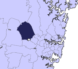 Location in Metropolitan Sydney | |||||||||||||
| Coordinates | 33°46′S 150°55′E / 33.767°S 150.917°ECoordinates: 33°46′S 150°55′E / 33.767°S 150.917°E | ||||||||||||
| Population | 339,328 (2015 Est.)[1] (5th) | ||||||||||||
| • Density | 1,254/km2 (3,250/sq mi) | ||||||||||||
| Established | 1979 | ||||||||||||
| Area | 246.9 km2 (95.3 sq mi) | ||||||||||||
| Time zone | AEST (UTC+10) | ||||||||||||
| • Summer (DST) | AEDT (UTC+11) | ||||||||||||
| Mayor | Stephen Bali[2] | ||||||||||||
| Council seat | Blacktown | ||||||||||||
| Region | Metropolitan Sydney | ||||||||||||
| State electorate(s) | |||||||||||||
| Federal Division(s) | |||||||||||||
|
| |||||||||||||
| Website | Blacktown City | ||||||||||||
| |||||||||||||
Blacktown City is a local government area in western Sydney, situated on the Cumberland Plain, approximately 35 kilometres (22 mi) west of the Sydney central business district, in the state of New South Wales, Australia. The City occupies an area of 246.9 square kilometres (95.3 sq mi) and had a population of almost 340,000 in 2015.
The City is bounded by the cities of Penrith, Parramatta, Fairfield, Holroyd, Hawkesbury and The Hills Shire.
Blacktown was originally named for an Australian Aboriginal settlement in the area. Today, Blacktown continues to be home to the largest Aboriginal population of any suburb or township in New South Wales. A school for Aborigines was moved in 1823 from Parramatta to the site where Richmond Road meets Rooty Hill Road North. The road from Prospect to Richmond became known as the Black Town Road. In 1860 the Railway Department gave the name of Black Town Road Station to the railway station at the junction of the railway and the Black Town Road, with the name shortening to Blacktown by 1862.
The Mayor of the City of Blacktown is Stephen Bali, of the Australian Labor Party. He is also the assistant secretary of the Greater New South Wales branch of the Australian Workers' Union.
Suburbs and localities of the City of Blacktown
These are the suburbs and localities in the local government area:
- Acacia Gardens
- Arndell Park
- Bidwill
- Blackett
- Blacktown
- Bungarribee
- Colebee
- Dean Park
- Dharruk
- Doonside
- Eastern Creek
- Emerton
- Glendenning
- Glenwood
- Hassall Grove
- Hebersham
- Huntingwood
- Kellyville Ridge
- Kings Langley
- Kings Park
- Lalor Park
- Lethbridge Park
- Marayong
- Marsden Park
- Minchinbury
- Mount Druitt
- Oakhurst
- Parklea
- Plumpton
- Prospect (shared with Cumberland Council)
- Quakers Hill
- Riverstone
- Ropes Crossing
- Rooty Hill
- Rouse Hill (shared with The Hills Shire
- Schofields
- Seven Hills (shared with City of Parramatta Council)
- Shalvey
- Shanes Park
- Stanhope Gardens
- St Marys (shared with City of Penrith)
- The Ponds
- Toongabbie (shared with City of Parramatta Council and Cumberland Council)
- Tregear
- Vineyard
- Whalan
- Willmot
- Woodcroft
Demographics
At the 2011 Census, there were 301,099 people in the Blacktown local government area, of these 49.7% were male and 50.3% were female. Aboriginal and Torres Strait Islander people made up 2.7% of the population, which was slightly higher than the national average. The median age of people in the City of Blacktown was 32 years, which was significantly lower than the national median of 37 years. Children aged 0 – 14 years made up 23.7% of the population and people aged 65 years and over made up 9.0% of the population. Of people in the area aged 15 years and over, 51.7% were married and 10.3% were either divorced or separated.[3]
Population growth in the City of Blacktown between the 2001 Census and the 2006 Census was 6.47%; and in the subsequent five years to the 2011 Census, population growth was 10.82%. When compared with total population growth of Australia for the same periods, being 5.78% and 8.32% respectively, population growth in Blacktown local government area was nearly 25% more than the national average.[4] The median weekly income for residents within the City of Blacktown was generally on par with the national average.[3][5]
At the 2011 Census, the proportion of residents in the Blacktown local government area who stated their ancestry as Filipino, was in excess of six times the national average. The proportion of residents who stated a religious affiliation with Hinduism was in excess of three times the national average; the proportion of Catholics was 33% above the national average; and the proportion of residents with no religion about half the national average. Meanwhile, as at the Census date, the area was linguistically diverse, with Tagalog, Hindi, Punjabi, or Filipino languages spoken in households, and ranged from five times to eight times the national averages.[3]
| Selected historical census data for Blacktown local government area | |||||
|---|---|---|---|---|---|
| Census year | 2001[4] | 2006[5] | 2011[3] | ||
| Population | Estimated residents on Census night | 255,195 | 271,709 | 301,099 | |
| LGA rank in terms of size within New South Wales | 1st | ||||
| % of New South Wales population | 3.88% | ||||
| % of Australian population | 1.36% | ||||
| Cultural and language diversity | |||||
| Ancestry, top responses | Australian | 30.0% | |||
| English | 24.8% | ||||
| Filipino | 6.7% | ||||
| Indian | 3.7% | ||||
| Irish | 6.7% | ||||
| Language, top responses (other than English) | Tagalog | 5.1% | |||
| Hindi | 1.8% | ||||
| Arabic | 2.9% | ||||
| Punjabi | 0.8% | ||||
| Filipino | n/c | ||||
| Religious affiliation | |||||
| Religious affiliation, top responses | Catholic | 36.3% | |||
| Anglican | 19.6% | ||||
| No Religion | 8.4% | ||||
| Islam | 3.5% | ||||
| Hinduism | 2.3% | ||||
| Median weekly incomes | |||||
| Personal income | Median weekly personal income | A$473 | |||
| % of Australian median income | 101.5% | ||||
| Family income | Median weekly family income | A$1,105 | |||
| % of Australian median income | 107.6% | ||||
| Household income | Median weekly household income | A$1,188 | |||
| % of Australian median income | 101.5% | ||||
Council
Current composition and election method
Blacktown City Council is composed of fifteen Councillors elected proportionally as five separate wards, each electing three Councillors. All Councillors are elected for a fixed four-year term of office. The Mayor is elected by the Councillors at the first meeting of the Council. The most recent election was held on 10 September 2016, and the makeup of the Council is as follows:[6][7][8][9][10]
| Party | Councillors | |
|---|---|---|
| Australian Labor Party | 10 | |
| Liberal Party of Australia | 5 | |
| Total | 15 | |
[11] The current Council, elected in 2016, in order of election by ward, is:
| Ward | Councillor | Party | Notes | |
|---|---|---|---|---|
| First ward[6] | Chris Quikley | Labor | ||
| Jess Diaz | Liberal | |||
| Moninder Singh | Labor | |||
| Second ward[7] | Leo Kelly | Labor | ||
| Jaymes DIaz | Liberal | |||
| Julie Griffiths | Labor | |||
| Third ward[8] | Susai Benjamin | Labor | ||
| Kathie Collins | Labor | |||
| Frederick Brillo | Liberal | |||
| Fourth ward[9] | Stephen Bali | Labor | Mayor[12] | |
| Carol Israel | Labor | |||
| Linda Santos | Liberal | |||
| Fifth ward[10] | Tony Bleasdable | Labor | ||
| Brad Bunting | Labor | |||
| Peter Camilleri | Liberal | |||
Heraldic coat of arms
After becoming a city in 1979, the city council resolved to investigate and if possible obtain a coat of arms.[13] The device features:
- In the centre, a generic profile of an Australian Aboriginal
- A Kangaroo, kookaburra and wattle boughs, representing the flora and fauna of the region
- A Brumby, signifying early industry in the area (breeding horses and capturing wild horses)
- The motto, 'Progress
Growth and development
Blacktown's growth has been sustained and rapid, contributing to its present status as the most populous City in New South Wales, the third largest in Australia behind Brisbane City and the Gold Coast and the eighth fastest growing City in Australia. Large scale urban development has contributed to Blacktown's continued population growth and to the development of new estate places which has led to the establishment of 45 suburbs to date. Blacktown therefore encompasses a mix of older established areas and new developing areas.
Blacktown's diverse land use continues to attract developers and retailers to the largest quantity of zoned and serviced industrial and commercial land throughout NSW. Blacktown is considered to be one of the best suburbs in Sydney for Real Estate investment.[14] Blacktown's city centre provides residents with numerous shopping facilities and services and is the commercial centre for government departments and local business. This includes a court house, police station, shared State Government Office building, and the Westpoint shopping mall.
Transport
Access into and out of Blacktown is provided by the transport links including the North Shore, Northern & Western Line between Sydney, Penrith and Richmond; the Great Western Highway, Richmond Road; plus the M2, M4, and M7 Motorways. There are 1,019 kilometres (633 mi) of local roads and 100 kilometres (62 mi) of regional roads within Blacktown. The Blacktown railway station is an interconnecting station for long distance services between Dubbo and the country terminal at Sydney Central. It is also a bus interchange used by Hillsbus, Busways and Transit Systems transport operators providing connection to local suburbs not directly linked by rail.
These private bus companies offer interconnection services between many of the railway stations within the City of Blacktown and beyond, extending the reach of public transport along the main road corridors of the Great Western Highway, Prospect Highway, Richmond Road, Windsor Road and other major roads throughout the area. Cycling is being increasingly catered for throughout the city. The Council has a published map showing over 65 kilometres (40 mi) of existing cycleway (including some cycleways on shared roads), however there are extensive biking and walking tracks which are not included on that map.[15] Blacktown City Council proposed that by December 2006 there would be 125 kilometres (78 mi) of cycleways assisting in providing safe bicycle access throughout the city. This does not include recreational cycleways such as those in the various parks and gardens throughout the area.
Natural environment
The Western Sydney Parklands (within it is the Nurragingy Reserve in Doonside), Eastern Creek, Ropes Creek, South Creek, and Prospect Creek provide a natural buffer between areas of urban development. A total of eight creeks and tributaries form part of the two major catchments of the area including the Nepean Hawkesbury Catchment and the Upper Parramatta River Catchment.
Tourist attractions
Popular tourist attractions in Blacktown include Featherdale Wildlife Park at Doonside and Wonderland Theme Park, at Eastern Creek before it was closed down in 2004. Many celebrities have visited Featherdale, including Leonardo DiCaprio, Gwen Stefani, Kristen Stewart and Taylor Lautner.[16][17] Westpoint Shopping Centre is a popular place for local residents and visitors of Blacktown. One of its cinemas has the largest standard cinema screen in Australia. Blacktown has one of the two last remaining Drive-in Theatre in Sydney. Every Sunday morning the Blacktown Markets takes place on the grounds of the Drive-In. Another popular market is Parklea Markets.[18] A Wet 'n' Wild water park opened in 2013.
History
A school for Aborigines was moved in 1823 from Parramatta to the now abandoned tower near the site where Richmond Road meets Rooty Hill Road North (this intersection is now in the suburbs of Hassall Grove, Glendenning and Quakers Hill. The road from Prospect to Richmond became known as the Black Town Road. In 1860 the Railway Department gave the name of Black Town Road Station to the railway station at the junction of the railway and the Black Town Road, with the name shortening to Blacktown by 1862. Today, the City of Blacktown continues to be home to the largest Aboriginal population of any metropolitan local government area. It has a large population of migrants to Australia and is the largest of any suburb or township in New South Wales.
Sister cities
Blacktown City Council has sister city relations with the following cities:[19]
 Porirua, New Zealand, since 1984
 Suseong-gu, Daegu, South Korea, since 1994
 Liaocheng, China, since 2003
 Liverpool Plains, Australia, since 2005
Notable residents
- Michael Clifford from pop-rock band 5 Seconds of Summer
References
- ↑ "3218.0 – Regional Population Growth, Australia, 2014–15". Australian Bureau of Statistics. Retrieved 29 September 2016.
- ↑ http://www.stmarysstar.com.au/story/2568168/stephen-bali-new-blacktown-mayor-in-shock-vote/?cs=1256
- 1 2 3 4 Australian Bureau of Statistics (31 October 2012). "Blacktown (C)". 2011 Census QuickStats. Retrieved 5 November 2012.
- 1 2 Australian Bureau of Statistics (9 March 2006). "Blacktown (C)". 2001 Census QuickStats. Retrieved 12 November 2012.
- 1 2 Australian Bureau of Statistics (25 October 2007). "Blacktown (C)". 2006 Census QuickStats. Retrieved 12 November 2012.
- 1 2 "Blacktown City Council – Ward 1". Local Government Elections 2012. Electoral Commission of New South Wales. 15 September 2012. Retrieved 21 September 2012.
- 1 2 "Blacktown City Council – Ward 2". Local Government Elections 2012. Electoral Commission of New South Wales. 15 September 2012. Retrieved 21 September 2012.
- 1 2 "Blacktown City Council – Ward 3". Local Government Elections 2012. Electoral Commission of New South Wales. 15 September 2012. Retrieved 21 September 2012.
- 1 2 "Blacktown City Council – Ward 4". Local Government Elections 2012. Electoral Commission of New South Wales. 15 September 2012. Retrieved 21 September 2012.
- 1 2 "Blacktown City Council – Ward 5". Local Government Elections 2012. Electoral Commission of New South Wales. 15 September 2012. Retrieved 21 September 2012.
- ↑ http://www.votensw.info/blacktown-city-council
- ↑ "Blacktown City Council - Mayor and Councillors". Blacktown City Council. 15 September 2015. Retrieved 18 April 2016.
- ↑ "Coat of Arms". Our City: History. Blacktown City Council. 2012. Retrieved 21 September 2012.
- ↑ Craze, Kirsten (20 February 2012). "Blacktown bucks trend, declared a suburb to watch on Sydney's property market". The Daily Telegraph. Australia. Retrieved 21 September 2012.
- ↑ "Access Around The City". Our city. Blacktown City Council. 2012. Retrieved 21 September 2012.
- ↑ "Blake Lively and Leonardo DiCaprio have an animal attraction at Featherdale Wildlife Park". The Daily Telegraph. Australia. 31 August 2011. Retrieved 21 September 2012.
- ↑ McCabe, Kathy (1 August 2007). "Gwen opens up in Sydney". The Daily Telegraph. Australia. Retrieved 21 September 2012.
- ↑ "The Biggest Market Place in the Southern Hemisphere". Parklea Markets. 2007. Retrieved 21 September 2012.
- ↑ "Sister Cities". Your Council. Blacktown City Council. 2012. Retrieved 21 September 2012.
External links
- City of Blacktown's website
- VisitBlacktown.com – Information on Tourist Attractions in Blacktown
- The 2001 City of Blacktown Social Plan