Sutherland, New South Wales
| Sutherland Sydney, New South Wales | |||||||||||||
|---|---|---|---|---|---|---|---|---|---|---|---|---|---|
 Overlooking Sutherland | |||||||||||||
| Population | 9,923 (2011 census)[1] | ||||||||||||
| Established | 1906 | ||||||||||||
| Postcode(s) | 2232 | ||||||||||||
| Location | 30 km (19 mi) south of Sydney CBD | ||||||||||||
| LGA(s) | Sutherland Shire | ||||||||||||
| State electorate(s) | Miranda, Heathcote | ||||||||||||
| Federal Division(s) | Hughes | ||||||||||||
| |||||||||||||

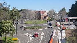
Sutherland is a suburb in southern Sydney, in the state of New South Wales, Australia. Sutherland is located 30 kilometres south of the Sydney central business district and is the administrative centre for the local government area of the Sutherland Shire.
History
There are two theories for the origin of the Sutherland name:[2]
- It is suggested that the name was taken from able seaman Forby Sutherland, who died on Captain Cook's Endeavour voyage. Sutherland Point at Kurnell is named after him, but there's no direct connection of him to the Sutherland Shire district.
- Thomas Mitchell as surveyor general in 1835 named the first parish south of the Georges River as the "Parish of Southerland" (South with an "o"). But it appeared in a later government gazette spelt Sutherland, losing the significance of the name.
Thomas Holt (1811–88) purchased 13,000 acres (53 km2) in the 1860s that stretched from Sutherland to Cronulla. The Sutherland area was originally heavily timbered and timber-cutting became the first industry. Holt initiated many commercial projects including timber cutting, coal mining, sheep farming and oyster farming. He built a forty-room mansion called Sutherland House in 1881 at Sylvania, on the bank of Gwawley Bay. The mansion was destroyed by fire in 1918, thought to have been deliberately lit.[3]
The first road through the area was South Road constructed in 1842. Later Illawarra Road was built along the ridges of high land to the Woronora River. The Princes Highway became the main thoroughfare through Sutherland, linking Sydney to the Illawarra region.
The railway line was constructed in the 1880s and development followed. Residents lived in humpies or tents in the bush. Once the land was cleared, a township developed around the railway station. In 1886 there were only four permanent buildings: the railway station, the station master's residence, the railway keeper's cottage and a general store run by a man called Bramley. The post office opened on 1 September 1886 and a school began classes in 1887. In 1906, the shire of Sutherland was proclaimed and the name Sutherland was officially declared. The first meetings were held in the shire clerk's home and the Council Chambers were built in 1915.[4] By the 1920s, steam trams operated between Cronulla and Sutherland.
Woronora Memorial Park
In 1897, land was set aside west of Sutherland Station for a denominational cemetery, as an alternative to a site at Kurnell, which would have required a long branch line. A single track line 822 metres (2,697 ft) long was constructed next to the station and opened on 13 June 1900.[5] A single platform 134.1 m (440.0 ft) long and a loop for engines were included. The first funeral had taken place earlier that year, with the casket arriving by train from Mortuary Station in the city. However, due to the advent of the motor car and motorised funerals, funerals by train eventually fell out of favour, with the result that the line closed on 23 May 1947, with no funeral having taken place for some years beforehand. The line and platform were subsequently demolished and removed; no remains, apart from the original formation coming from the main line, are visible today.[6]
Commercial area
Sutherland is a mostly residential area with a shopping centre located close to Sutherland station. Some commercial developments are also located on the Princes Highway. As the administrative centre of the Sutherland Shire, Sutherland hosts facilities such as a general purpose entertainment centre where citizenship ceremonies take place, a community centre, local government council offices and Sutherland Library, a major central library. Woronora Cemetery sits on the western border of the suburb.
Transport
Sutherland station is a junction on the Illawarra line of the Sydney Trains network. The main line runs south to Waterfall and Wollongong and north to Bondi Junction, and a branch line runs east to Cronulla.
For details of bus services see Sutherland Station
When the Southern Freeway (also known as the F6) was built linking Sydney to Wollongong, the Princes Highway was diverted away from the centre of Sutherland using Acacia Road. An F6 extension has been proposed for many years, which would link Sutherland to the Captain Cook Bridge via Miranda and onto the Southern Cross Drive via Brighton-Le-Sands.
Schools
Sutherland Public School, Sutherland North Public School, Minerva School, St Patrick's College., St Patrick's Primary School.
Churches
St Patrick's Catholic Church, St John the Baptist Anglican Church, St Andrews Presbyterian Church, Sutherland Uniting Church, Good Shepherd Lutheran Church Sutherland [7] Christadelphian Church[8] and Shirelive Church (Pentecostal).
Parks
Prince Edward Park, Sutherland Park, Waratah Park, Peace Park, Forby Sutherland Memorial Garden, Sutherland Community Gardens, Clio Street Reserve, Glencoe Street Reserve, Gray Street Reserve, Leonay Street Reserve.
Prince Edward Park is a large park situated between the Woronora River and Sutherland. Along the river, a cleared area was created as a recreational park, with facilities for boating and fishing. It is also the location for the Sutherland Region Guides Hall and the Woronora Life Saving Club. Going towards Sutherland, the park is natural Eucalyptus bushland, with some walking trails.
Sport and recreation
Sutherland Leisure Centre located on Rawson Avenue features a 50-metre heated outdoor pool, an international size water polo pool and a multi-functional family fun and recreation area incorporating both a 50-metre and 25-metre indoor pool, spa and steamroom. The gymnasium offers fitness equipment, fitness classes, boxing / fitness circuit, martial arts room and beach volleyball court.
Since 1963 Sutherland Oval has been the home ground of the North Sutherland Rockets. The club competes in the Sutherland Shire Football Association Competition.
Population
In the 2011 Australian census, there were 9,923 residents in Sutherland. 70.1% of the population was born in Australia, with the other top countries of birth being England 3.7%, New Zealand 2%, China(exclude SARs) 1.7%, Indian 1.0% and the Philippines 0.7%.In religion, 25.9% identify as Catholic, 23.1% Anglican, 19.2% No religion, and 3.7% Uniting Church.
Notable residents
_02.jpg)
- Mitch Brown, rugby league footballer.
- William Carpenter, Australian politician.
- Stuart Clark, Australian international cricketer.
- Andrew Ettingshausen, rugby league footballer.
- Rochelle Gilmore, Australian racing cyclist.
- Margaret Packham Hargrave, writer, poet, former Sutherland Shire Councillor.[9]
- Matt Hilder, rugby league footballer.
- Sam Isemonger, rugby league footballer.
- Kid Courageous, Australian pop punk band.
- Danielle LeRay, Australian rhythmic gymnast.
- Wes Naiqama, rugby league footballer.
- Arthur Pappas, rugby league footballer.
- Napoleon Perdis, Australian make-up artist and businessman.
- Ashton Sims, rugby league footballer.
- David Simmons, rugby league footballer.
- Kirsten Thomson, Australian swimmer.
- Vinnie Calabrese, Australian snooker player.
References
- ↑ Australian Bureau of Statistics (25 October 2007). "Sutherland (State Suburb)". 2006 Census QuickStats. Retrieved 29 November 2007.
- ↑ Sutherland Shire place names, fact sheet by the Sutherland Shire, August 2003
- ↑ The Book of Sydney Suburbs, Compiled by Frances Pollen, Angus & Robertson Publishers, 1990, Published in Australia ISBN 0-207-14495-8
- ↑ http://www.sutherland.nsw.gov.au/ssc/rwpattach.nsf/0/Factsheet_6_FINAL_20030728.pdf/$file/Factsheet_6_FINAL_20030728.pdf
- ↑ Forsyth, J.H. (ed.) (1988–93), Stations & Tracks; Vol. 1: "Main Suburban & Branches – Illawarra & Branches". State Rail Authority of New South Wales: Sydney, p. 125.
- ↑ Neve, Peter (1997), "Railways (and tramways) in the Sutherland Shire": (Sutherland Shire Studies No. 6), Sutherland Shire Council. Retrieved 4 March 2013.
- ↑ "Church Search Results". lca.org.au. Retrieved 9 June 2014.
- ↑ 'Sutherland' on thisisyourbible.com
- ↑ "Sutherland Shire Council - Mayor, councillors and elections". 22 September 2009. Retrieved 14 February 2010.
| Wikimedia Commons has media related to Sutherland, New South Wales. |
External links
- Sutherland Shire Council
- Helen McDonald - Sutherland Library (2008). "Sutherland". Dictionary of Sydney. Retrieved 29 September 2015. [CC-By-SA]
Coordinates: 34°01′59″S 151°03′30″E / 34.03314°S 151.05830°E