Woronora Dam
| Woronora Dam | |
|---|---|
|
Aerial view of Woronora Dam reservoir | |
 Location of the Woronora Dam in New South Wales | |
| Country | Australia |
| Location | south of Sydney, New South Wales |
| Coordinates | 34°6′40″S 150°56′4″E / 34.11111°S 150.93444°ECoordinates: 34°6′40″S 150°56′4″E / 34.11111°S 150.93444°E |
| Status | Operational |
| Construction began | 1927 |
| Opening date | 1941 |
| Construction cost | A$13 million |
| Owner(s) | Sydney Catchment Authority |
| Dam and spillways | |
| Type of dam | Gravity dam |
| Impounds | Woronora River |
| Height | 66 m (217 ft) |
| Length | 390 m (1,280 ft) |
| Dam volume | 285×103 m3 (10.1×10⁶ cu ft) |
| Spillway capacity | 1,470 m3/s (52,000 cu ft/s) |
| Reservoir | |
| Creates | Woronora Dam |
| Total capacity | 71,790 ML (2,535×106 cu ft) |
| Catchment area | 75 km2 (29 sq mi) |
| Surface area | 380 ha (940 acres) |

The Woronora Dam is a concrete gravity dam with an uncontrolled serpentine spillway across the Woronora River, located south of Greater Metropolitan Sydney, in New South Wales, Australia. The principal purpose of the dam is for potable water supply for Sydney's southern suburbs and the northern suburbs of the Illawarra region. The impounded 71,790-megalitre (2,535×106 cu ft) reservoir is also called Woronora Dam and is sometimes incorrectly called Lake Woronora.
History
Water was first supplied to the Sutherland Shire in 1911 when a 150-millimetre (5.9 in) pipe was laid from Penshurst Reservoir across Georges River at Tom Ugly's Point to Miranda.[1] In 1920 a scheme to supply water from the Woronora River to Sutherland and Cronulla was rejected. It was resurrected five years later when the then Metropolitan Water Sewerage and Drainage Board became the sole constructing authority for water supply works in the metropolitan area. The scheme involved the construction of a dam, which could be increased in size if necessary, on the Woronora River, about 24 kilometres (15 mi) upstream of its junction with the Georges River.[2]
Construction of the dam began in 1927, the fifth dam built as part of Sydney's water supply.[1] As forecast, the size of the dam wall had to be increased two years later. Workers' accommodation was spartan but functional with small bungalows built of fibrolite and placed on brick or concrete piers on the sloping ground. In 1930 The Depression intervened, suspending work on the dam. The men were forced to look for work further afield, even interstate, often leaving their families behind to live on the Woronora site. Some families had strong ties to the history of Sydney's dams, moving from the Nepean Dam project to Woronora, and then onto Warragamba. Other workers on Woronora Dam were former coal miners from nearby Helensburgh. Late in 1931 the Unemployment Relief Account released funds to build a weir to provide water to the Sutherland-Cronulla area and four years later, work resumed on the dam itself.[2]
Woronora Dam was completed in 1941 at a cost of about A$13 million. The dam is the only one of Sydney's water supply dams which is not part of the Upper Nepean/Warragamba/Shoalhaven interconnected system. The dam was built with the objective of supplementing Sydney's water supply whilst the much larger Warragamba Dam was constructed.[1] Six of the cottages were retained for on-site maintenance staff housing while the rest of Woronora township site was turned into picnic and recreational areas.[2]
Features and location
Woronora Dam is curved in appearance and is a mass gravity dam, remaining in position under its own weight. The dam wall has a height of 66 metres (217 ft) and a length of 390 metres (1,280 ft). Its lower levels are built of cyclopean masonry - massive sandstone blocks that were quarried on site. The 285-thousand-cubic-metre (10.1×10⁶ cu ft) main wall is made from blue metal and gravel concrete and there are two inspection galleries located inside. The dam has a separate, serpentine overflow spillway that discharges floodwater at the rate of 1,470 m3/s (52,000 cu ft/s) through a concrete lined cutting into the river downstream of the dam. In 1988 Woronora Dam was upgraded at a cost of A$2.9 million by a system of wall and foundation drains to meet international dam safety standards.[2][3]
The 75-square-kilometre (29 sq mi) catchment area together with the facilities at the dam are managed by the Sydney Catchment Authority. While there are no towns in the catchment area, parts of the Princes Highway, Heathcote Road and the Illawarra railway line pass through the area and the urban areas of Sutherland and Campbelltown are nearby.[4]
Raw water from Woronora Dam is pumped to the adjacent Woronora Water Filtration Plant. This plant is one of nine in Sydney either operated by Sydney Water or privately owned and operated under contract to Sydney Water. The dam and water filtration plant supply water to the areas south of the Georges River including Sutherland, Helensburgh, Otford, Stanwell Tops, Stanwell Park, Coalcliff, Lucas Heights and Bundeena.
The Maritime Operations Division within the Department of Defence use the Woronora Dam reservoir to test its sonar facilities. The testing station is on a pontoon in the middle of the reservoir.
The dam can be viewed by the public, and has a walking trail across the dam wall, and a picnic area including a carpark. Woronora Dam Road leads from the Princes Highway for seven kilometres to the dam.
Popular culture
The building of the Woronora Dam became part of the backdrop of the comedy drama Dad Rudd MP. The film featured several construction scenes and employed many workers and their families as 'extras'.
Gallery
 Woronora Dam reservoir and surrounding catchment area
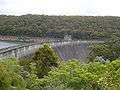 Woronora Dam at 54% capacity
 Woronora Dam Spillway
See also
References
- 1 2 3 "Woronora-Penshurst Pipeline". Heritage item. Sydney Water. 5 March 2014 [3 June 1988]. Retrieved 10 March 2014.
- 1 2 3 4 Aird, W. V. (1961). The Water Supply, Sewerage and Drainage of Sydney. Metropolitan Water Sewerage and Drainage Board.
- ↑ "Register of Large Dams in Australia" (Excel (requires download)). Dams information. Australian National Committee on Large Dams. 2010. Retrieved 10 March 2014.
- ↑ "Woronora Dam". Sydney Catchment Authority. Retrieved 10 March 2014.
External links
- "Georges River catchment" (map). Office of Environment and Heritage. Government of New South Wales.
- Woronora Dam photos on Geolocation.ws