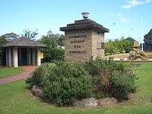
Liverpool, New South Wales
| Liverpool Sydney, New South Wales | |||||||||||||
|---|---|---|---|---|---|---|---|---|---|---|---|---|---|
 Westfield Liverpool Shopping Centre | |||||||||||||
| Population | 24,095 (2011 census)[1] | ||||||||||||
| Established | 1810 | ||||||||||||
| Postcode(s) | 2170 | ||||||||||||
| Location | 32 km (20 mi) south-west of Sydney CBD | ||||||||||||
| LGA(s) | City of Liverpool | ||||||||||||
| State electorate(s) | Liverpool, Holsworthy | ||||||||||||
| Federal Division(s) | Fowler | ||||||||||||
| |||||||||||||

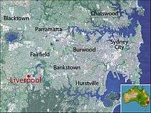
Liverpool is a suburb of Sydney, in the state of New South Wales, Australia. It is located in Greater Western Sydney 32 kilometres (20 mi) south-west of the Sydney central business district. Liverpool is the administrative seat of the local government area of the City of Liverpool.
History
Liverpool is one of the oldest urban settlements in Australia, founded on 7 November 1810 [2] as an agricultural centre by Governor Lachlan Macquarie. He named it after Robert Banks Jenkinson, Earl of Liverpool, who was then the Secretary of State for the Colonies and the British city of Liverpool, upon which some of the area's architecture is based.[3]
Liverpool is at the head of navigation of the Georges River and combined with the Great Southern Railway from Sydney to Melbourne reaching Liverpool in the late 1850s, Liverpool became a major agricultural and transportation centre as the land in the district was very productive.
Until the 1950s, Liverpool was still a satellite town with an agricultural economy based on poultry farming and market gardening. However the tidal surge of urban sprawl which engulfed the rich flatlands west of Sydney known as the Cumberland Plain soon reached Liverpool, and it became an outer suburb of metropolitan Sydney with a strong working-class presence and manufacturing facilities. The Liverpool area also became renowned for its vast Housing Commission estates housing thousands of low-income families after the slum clearance and urban renewal programs in inner-city Sydney in the 1960s.
The following buildings are listed on the Register of the National Estate or the State Heritage Register:[4]
- Technical College (formerly Liverpool Hospital), probably designed by Francis Greenway, circa 1825–30
- Former Court House, corner of Bigge and Moore Streets, extended circa 1855
- Collingwood (also known as Captain Bunker's Cottage), Birkdale Crescent, circa 1810, extended circa 1860
- Liverpool Dam, Georges River, built 1836, designed by David Lennox
- St Luke's Anglican church, designed by Francis Greenway, 1818
- Liverpool Railway Station[5]
- Rosebank (formerly home of architect Varney Parkes), Speed Street, 1882–83
- Del Rosa (formerly home of Dr James Pirie), Speed Street
- Liverpool Fire Station, Terminus Street
- Memorial School of Arts, Macquarie Street, 1924
- New Commercial Hotel (formerly Ground Zero Hotel), corner Bigge and Scott Streets, 1896
Commercial area

Liverpool is currently the major city centre in South Western Sydney. The city centre has a Hoddle Grid layout with many little laneways and arcades, similar to that of Melbourne. The main strip is Macquarie Street which contains numerous small cafes. In recent times the extension of the Westfield shopping centre has seen many new fashion stores come in.
The main shopping area is centred on Macquarie Street, with Westfield Liverpool, a major shopping centre at the northern end. Liverpool Plaza is located between Macquarie Mall & Northumberland Street. The northern end of the city has been zoned for high density residential apartments. The southern end of the city is zoned for high density commercial developments. Liverpool has a large teaching hospital, two technical colleges and many shopping centres and office buildings. The private hospital operator Healthscope owns the Sydney Southwest Private Hospital in Liverpool.
Transport
Liverpool is well served by roads such as the Hume Highway (also known as Liverpool Road), the M5 motorway, the Westlink M7 motorway.
Liverpool railway station has services to Sydney CBD and Campbelltown as well as two morning peak services to Parramatta on most weekdays. The Liverpool to Parramatta transitway provides a bus-only route for buses.
For details of long distance and local bus services see Liverpool Station

Schools and places of worship
| Liverpool, New South Wales | |
|---|---|
 St Lukes Anglican Church | |
| 33°55′14″S 150°55′24″E / 33.920633°S 150.923395°E | |
| Location | City of Liverpool |
| Country | Australia |
| Denomination | Anglican Church |
| Website | http://www.stlukesliverpool.org.au/ |
| History | |
| Dedication | 1820 |
| Architecture | |
| Architect(s) | Francis Greenway |
| Groundbreaking | 1818 |
There are three public primary schools within the suburb of Liverpool: Liverpool Public School, Liverpool West and Marsden Road. Liverpool Boys and Liverpool Girls are the two public secondary schools. The Mainsbridge School caters to children with intellectual disabilities and Liverpool Hospital School for children hospitalised for lengthy periods.
Private schools include All Saints Primary School, All Saints Catholic College and Al Amanah College.
Post secondary education is catered to with the South Western College of TAFE, Macarthur Community College, Liverpool U3A: School for Seniors, University of Western Sydney English Language Centre and the School of Arts in Macquarie Street.
St Lukes Anglican Church, located in the city centre across the road from Westfield Liverpool, is the oldest Anglican church in Australia.[6][7] All Saints Catholic Church in George St is located with the All Saints schools. St Raphael, Nickolas and Irene Greek Orthodox Church is in Forbes Street and the Serbian Orthodox Church of the Apostle Luke is on Flowerdale Rd.
Sport and recreation
Parks
There are many open spaces within the city centre, including botanical parks and sporting facilities. Bigge Park on the east side of the city features a War Memorial while Pioneer Memorial Park to the north has a historical cemetery. Woodward Park to the west is the main sporting precinct containing a number of outdoor playing fields and the Whitlam Leisure Centre, hosting a swimming pool and a 3000-seat indoor sports stadium. Other notable sports facilities within the suburb of Liverpool include Collimore Park (netball) and Paciullo Park (soccer and touch football).
Sporting teams
Prominent local teams include Fairfield-Liverpool Cricket Club which plays in the Sydney Grade Cricket competition, Liverpool City Netball, which has participated successfully in many State and representative competitions, Hinchinbrook Hornets Junior Rugby League and FC Bossy Liverpool which plays in the New South Wales Super League. The West Sydney Razorbacks basketball team used to play out of the Gough Whitlam Centre while they were in the NBL. Liverpool is also home to Australian Ice Hockey League team the Sydney Ice Dogs who play out of the Liverpool Catholic Club Ice Rink and Liverpool little athletics.
Media
Liverpool has an arts and creation centre which provides music lessons with instruments such as:guitar,drums and banjo etc.
Liverpool is currently served by a full-time radio station 89.3FM 2GLF which broadcasts local information, music and ethnic programming. It is one of the first FM radio stations setup in the early '80s.
Liverpool has had several newspapers since the late 1800s. The first newspaper appeared in Liverpool in 1886 was The Liverpool Times which was soon superseded by The Liverpool Mercury. Both of these newspapers were then incorporated with The Liverpool Herald. There was also the free newspaper The Liverpool News that ran from 1904 to about 1973. Liverpool now has two newspapers, The Liverpool Leader and The Liverpool Champion published every Wednesday.
Population
Demographics
According to the 2011 census conducted by the Australian Bureau of Statistics, Liverpool had a population of 180,143.[8][9] These came from a wide variety of ethnic backgrounds; less than one-third (32.4%) of residents were born in Australia, which is less than half of the national average of 69.8%. The next most common countries of birth were Iraq (9.5%), India (5.9%), Croatia (4.0%), Fiji (3.2%) and Bosnia and Herzegovina (3.2%). This should be considered together with residents' self-reported ancestry in the same census to show another aspect of their cultural identity: only 8.4% identified this as Australian; the most popular responses were Australian 8.4%, Indian 8.0%, English 7.5% and Iraqi 5.9%.[1]
The age distribution is just a little younger than the rest of the country: the median age of Liverpool residents was 33 years (national median is 37). Children aged 0–14 years made up 21.1% of the population (19.3% nationally) and people aged 65 years and over made up 11.1% of the population (14.0% nationally).[1]
Liverpool is remarkable for the high proportion of people who reported following some religion in the Census; only 6.1% stated that they had no religion, much lower than the national average of 22.3%. However, it should also be noted that this Census question is optional and 11.6% of residents did not respond to it, which introduces some uncertainty into all the religious figures. The most common responses for religion were Catholic 20.5%, Islam 13.3%, Eastern Orthodox 13.0%, Hinduism 7.5% and "Miscellaneous Religions" 7.1%.[1]
Over half (51.1%) the dwellings in Liverpool were apartments and 50.3% were being rented, which is significantly higher than the national average of 29.6%. The median rent of $280 was marginally lower than the national average ($285), but the average household income of $922 per week was substantially lower the national average of $1,234.[1]
Notable people from Liverpool
- Mark Bosnich, former footballer
- Michael Clarke, cricketer
- Sir Jenkin Coles, auctioneer and politician[10]
- Walter Hampson Cooper, journalist, playwright, politician and barrister[11]
- Nathan Foley, a former member of Hi-5, entertainer
- Isaac De Gois, rugby league player
- Frederick Augustus Forbes, store-keeper, grazier and politician[12]
- Scott Gardiner, first golfer of Aboriginal descent to play on the PGA Tour
- Jennifer Harrison, poet
- Vic Hey, rugby league player
- Brett Hodgson, rugby league player
- Craig Knowles, politician
- Anthony Minichiello, rugby league player
- Pat Richards, rugby league player
- Leonardo Zappavigna, boxer
Politics
| Recent elections in Liverpool | |||||
|---|---|---|---|---|---|
| Elections | Council 08 | Mayor 08 | NSW 07 | Federal 07 | |
| First Preference Results | |||||
| Labor | 46% | 41% | 59% | 65% | |
| Liberal | 21% | 19% | 19% | 26% | |
| LCIT | 15% | 6% | – | – | |
| Greens | – | – | 4% | 4% | |
| CDP | – | – | 4% | 2% | |
| Other parties | 7% | 4% | 3% | 2% | |
| Independents | 11% | 30%* | 11% | 1% | |
| * Combined results for four independents | |||||
| [13][14][15][16][17][18][19][20][21][22][23][24] | |||||
The suburb of Liverpool is split in its representation at all three levels of government with Hoxton Park Road the divider in each case. At the local level, Liverpool is part of the City of Liverpool, which is divided into two wards, the North Ward on the north side of Hoxton Park Road and the South Ward on the other side.[25] Each ward elects five councillors and the council currently consists of four Labor councillors, five Liberals, one member of the Liverpool Community Independents Team (LCIT) There is also a directly elected mayor, Liberal's Ned Mannoun.[26][27]
For New South Wales state elections, the north side of Liverpool is located in the Electoral district of Liverpool, held by Paul Lynch, while the south side is in the Electoral district of Macquarie Fields, held by Andrew McDonald.[28][29][30] Both men are members of the Australian Labor Party. Federally, the north side of Liverpool is located in the Division of Hughes held by Craig Kelly of the Liberal Party of Australia. The south side is part of the Division of Werriwa, held by Labor's Laurie Ferguson.[31][32]
The table at right illustrates recent election results in the Liverpool area by combining results from each of the five booths located in the suburb of Liverpool. The results indicate the suburb is a safe Labor area with the Labor primary vote well above 50% at both the last state and federal elections.
Climate
Liverpool has a humid subtropical climate (Köppen climate classification: Cfa) and is a few degrees warmer than the Sydney CBD, although nights are slightly cooler than Sydney's. If the maximum temperature is 27 °C in the City, in Liverpool it could typically reach as high as 33 °C, while in winter the temperature can be close to 0 °C while it is above 5 °C in central Sydney. Rainfall is almost evenly spread throughout the year, although the first half tends to be wetter, namely in March. July and September tend to be drier.
| Climate data for Liverpool, 1962–2001 | |||||||||||||
|---|---|---|---|---|---|---|---|---|---|---|---|---|---|
| Month | Jan | Feb | Mar | Apr | May | Jun | Jul | Aug | Sep | Oct | Nov | Dec | Year |
| Record high °C (°F) | 44.8 (112.6) |
45.8 (114.4) |
41.0 (105.8) |
37.1 (98.8) |
29.6 (85.3) |
25.9 (78.6) |
26.8 (80.2) |
30.5 (86.9) |
35.4 (95.7) |
39.8 (103.6) |
43.3 (109.9) |
43.5 (110.3) |
45.8 (114.4) |
| Average high °C (°F) | 28.2 (82.8) |
27.9 (82.2) |
26.4 (79.5) |
23.9 (75) |
20.5 (68.9) |
17.8 (64) |
17.3 (63.1) |
18.9 (66) |
21.5 (70.7) |
23.7 (74.7) |
25.3 (77.5) |
27.5 (81.5) |
23.2 (73.8) |
| Average low °C (°F) | 17.6 (63.7) |
17.7 (63.9) |
15.9 (60.6) |
12.4 (54.3) |
9.3 (48.7) |
6.3 (43.3) |
4.7 (40.5) |
5.8 (42.4) |
8.3 (46.9) |
11.5 (52.7) |
13.8 (56.8) |
16.2 (61.2) |
11.6 (52.9) |
| Record low °C (°F) | 7.8 (46) |
9.4 (48.9) |
5.0 (41) |
3.2 (37.8) |
−1.5 (29.3) |
−2.0 (28.4) |
−5.0 (23) |
−3.4 (25.9) |
−1.8 (28.8) |
3.3 (37.9) |
4.7 (40.5) |
7.8 (46) |
−5.0 (23) |
| Average precipitation mm (inches) | 97.6 (3.843) |
94.9 (3.736) |
101.0 (3.976) |
85.3 (3.358) |
68.8 (2.709) |
71.3 (2.807) |
40.2 (1.583) |
55.9 (2.201) |
45.6 (1.795) |
61.6 (2.425) |
78.3 (3.083) |
67.4 (2.654) |
867.7 (34.161) |
| Average precipitation days (≥ 0.1 mm) | 10.7 | 10.4 | 10.9 | 8.3 | 9.3 | 8.6 | 7.2 | 7.4 | 8.0 | 9.3 | 10.4 | 9.1 | 109.6 |
| Average relative humidity (%) | 54 | 55 | 56 | 52 | 58 | 54 | 50 | 44 | 45 | 45 | 49 | 51 | 51 |
| Source: [33] | |||||||||||||
References
- 1 2 3 4 5 Australian Bureau of Statistics (31 October 2012). "Liverpool(NSW)". 2011 Census QuickStats. Retrieved 12 April 2014.
- ↑ http://www.library.mq.edu.au/digital/lema/1810/1810nov.html#nov7
- ↑ The Book of Sydney Suburbs, Compiled by Frances Pollon, Angus & Robertson Publishers, 1990, p.155, ISBN 0-207-14495-8
- ↑ The Heritage of Australia, Macmillan Company, 1981, pp.2/41-42
- ↑ "Liverpool Railway Station group". State Heritage Register.
- ↑ Historic buildings vol III Liverpool and Campbelltown. Cumberland County Council. 1963. pp. 5–8. Retrieved 10 September 2016.
- ↑ "St. Luke's Anglican Church". Office of Environment & Heritage. Retrieved 14 September 2016.
- ↑ "About Liverpool and Our Community". Liverpool City Council. Retrieved 28 October 2015.
- ↑ Australian Bureau of Statistics (author) (2013), 2011 Census of Population and Housing : Country of Birth Profile, New South Wales, 2013, Australian Bureau of Statistics, retrieved 29 October 2015
- ↑ Edgar, Suzanne. Coles, Sir Jenkin (1843–1911). Canberra: National Centre of Biography, Australian National University.
- ↑ Nairn, Bede. Cooper, Walter Hampson (1842–1880). Canberra: National Centre of Biography, Australian National University.
- ↑ Morrison, A. A. Forbes, Frederick Augustus (1818–1878). Canberra: National Centre of Biography, Australian National University.
- ↑ "Liverpool City Council North Ward". Elections NSW. Retrieved 28 September 2009.
- ↑ "Liverpool City Council South Ward". Elections NSW. Retrieved 28 September 2009.
- ↑ "Liverpool City Council Mayor". Elections NSW. Retrieved 28 September 2009.
- ↑ "2007 State Elections Results – Liverpool". Elections NSW. Retrieved 28 September 2009.
- ↑ "2007 State Elections Results – Macquarie Fields". Elections NSW. Retrieved 28 September 2009.
- ↑ "Liverpool (Hughes)". Australian Electoral Commission. Retrieved 28 September 2009.
- ↑ "Liverpool North". Australian Electoral Commission. Retrieved 28 September 2009.
- ↑ "Liverpool West (Hughes)". Australian Electoral Commission. Retrieved 28 September 2009.
- ↑ "Marsden Road". Australian Electoral Commission. Retrieved 28 September 2009.
- ↑ "Liverpool (Werriwa)". Australian Electoral Commission. Retrieved 28 September 2009.
- ↑ "Liverpool South". Australian Electoral Commission. Retrieved 28 September 2009.
- ↑ "Liverpool West (Werriwa)". Australian Electoral Commission. Retrieved 28 September 2009.
- ↑ "Liverpool City Local Government Election 2008" (PDF). Elections NSW. Retrieved 2009-09-28.
- ↑ "Mayor Wendy Waller". Liverpool City Council. Retrieved 2009-09-28.
- ↑ "Liverpool City Council Mayoral Election". Elections NSW. Retrieved 2009-09-28.
- ↑ "Metropolitan Index Map". Elections NSW. Retrieved 2009-09-28.
- ↑ "The Hon Paul Gerald Lynch MP". Parliament of NSW. Retrieved 2009-09-28.
- ↑ "Dr Andrew Dominic McDonald MP". Parliament of NSW. Retrieved 2009-09-28.
- ↑ "Profile of the Electoral Division of Hughes". Australian Electoral Commission. Retrieved 2009-09-28.
- ↑ "Profile of the Electoral Division of Werriwa". Australian Electoral Commission. Retrieved 2009-09-28.
- ↑ "Climate statistics for Liverpool". Australian Bureau of Meteorology.
External links
| Wikimedia Commons has media related to Liverpool, New South Wales. |
Coordinates: 33°55′15″S 150°55′23″E / 33.92092°S 150.92314°E