Strawberry, El Dorado County, California
Coordinates: 38°47′49″N 120°08′43″W / 38.79694°N 120.14528°W
| Strawberry | |
|---|---|
| Unincorporated community | |
|
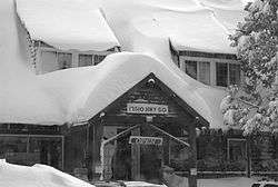
Strawberry Lodge after a winter storm, facing U.S. Route 50 | |
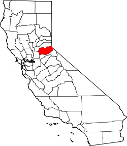
 Strawberry  Strawberry Location in California | |
| Coordinates: 38°47′49″N 120°08′43″W / 38.79694°N 120.14528°W | |
| Country | United States |
| State | California |
| County | El Dorado County |
| Elevation[1] | 5,738 ft (1,749 m) |
| ZIP code | 95735 (Twin Bridges, CA) |
| Area code(s) | 530 |
| FIPS code | 32-60600 |
| GNIS feature ID | 0861100 |
| Reference no. | 707 |
Strawberry is a small unincorporated community on the South Fork American River, 3.25 miles (5 km) south-southwest of Pyramid Peak,[2] along U.S. Route 50 in the foothills of the Sierra Nevada. The sign on the highway reads population 50.
The town became a popular resort in the 1850s, and a station along the Central Overland Pony Express. The site is now registered as California Historical Landmark #707.[3]
References
- ↑ U.S. Geological Survey Geographic Names Information System: Strawberry, El Dorado County, California
- ↑ Durham, David L. (1998). California's Geographic Names: A Gazetteer of Historic and Modern Names of the State. Clovis, Calif.: Word Dancer Press. p. 562. ISBN 1-884995-14-4.
- ↑ "Strawberry Valley House". Office of Historic Preservation, California State Parks. Retrieved 2012-10-07.
This article is issued from Wikipedia - version of the 7/5/2016. The text is available under the Creative Commons Attribution/Share Alike but additional terms may apply for the media files.