Shelocta, Pennsylvania
| Shelocta, Pennsylvania | |
|---|---|
| Borough | |
|
Main Street, with Grace Independent Baptist Church in the foreground | |
 Shelocta, Pennsylvania | |
| Coordinates: 40°39′20″N 79°18′07″W / 40.65556°N 79.30194°WCoordinates: 40°39′20″N 79°18′07″W / 40.65556°N 79.30194°W | |
| Country | United States |
| State | Pennsylvania |
| County | Indiana |
| Government | |
| • Type | Borough Council |
| Area | |
| • Total | 0.1 sq mi (0.3 km2) |
| Population (2010) | |
| • Total | 130 |
| • Density | 1,231.5/sq mi (475.5/km2) |
| Time zone | Eastern (EST) (UTC-5) |
| • Summer (DST) | EDT (UTC-4) |
| Zip code | 15774 |

Shelocta is a borough in Indiana County, Pennsylvania, United States. The population was 130 at the 2010 census. The Keystone Generating Station is located to the west of the borough, in Plumcreek Township, Armstrong County, Pennsylvania.
Geography
Shelocta Borough is located at 40°39′20″N 79°18′7″W / 40.65556°N 79.30194°W (40.655657, -79.301901).[1]
According to the United States Census Bureau, the borough has a total area of 0.1 square miles (0.26 km2), all of it land.
US Route 422 passes through Shelocta.
History
Shelocta Borough began as Sharp's Mills in 1822, when Thomas and Joseph Sharp erected a house, saw mill, and gristmill near the center of the modern village.
Abner Kelly laid out the village lots and first offered them for sale on May 20, 1835. The name Shelocta is from the Iroquois language, meaning "Shainee Cabin." The Shelocta Post Office began operations on November 1, 1837, under postmaster Daniel Metzker.
Natural Resources
Shelocta is in an area of Pennsylvania known for its coal and natural gas reserves, and is neighbored by many old company mining towns.
Demographics
| Historical population | |||
|---|---|---|---|
| Census | Pop. | %± | |
| 1860 | 137 | — | |
| 1870 | 113 | −17.5% | |
| 1880 | 121 | 7.1% | |
| 1890 | 82 | −32.2% | |
| 1900 | 92 | 12.2% | |
| 1910 | 117 | 27.2% | |
| 1920 | 124 | 6.0% | |
| 1930 | 135 | 8.9% | |
| 1940 | 114 | −15.6% | |
| 1950 | 105 | −7.9% | |
| 1960 | 89 | −15.2% | |
| 1970 | 121 | 36.0% | |
| 1980 | 139 | 14.9% | |
| 1990 | 108 | −22.3% | |
| 2000 | 127 | 17.6% | |
| 2010 | 130 | 2.4% | |
| Est. 2015 | 126 | [2] | −3.1% |
| Sources:[3][4][5] | |||
As of the census[4] of 2000, there were 127 people, 53 households, and 35 families residing in the borough. The population density was 1,231.5 people per square mile (490.3/km²). There were 55 housing units at an average density of 533.3 per square mile (212.4/km²). The racial makeup of the borough was 96.85% White, 2.36% African American, and 0.79% from two or more races.
There were 53 households, out of which 26.4% had children under the age of 18 living with them, 54.7% were married couples living together, 11.3% had a female householder with no husband present, and 32.1% were non-families. 32.1% of all households were made up of individuals, and 11.3% had someone living alone who was 65 years of age or older. The average household size was 2.40 and the average family size was 2.97.
In the borough the population was spread out, with 26.0% under the age of 18, 5.5% from 18 to 24, 28.3% from 25 to 44, 22.8% from 45 to 64, and 17.3% who were 65 years of age or older. The median age was 40 years. For every 100 females there were 89.6 males. For every 100 females age 18 and over, there were 84.3 males.
The median income for a household in the borough was $44,167, and the median income for a family was $45,833. Males had a median income of $25,000 versus $17,292 for females. The per capita income for the borough was $16,763. There were no families and 1.6% of the population living below the poverty line, including no under eighteens and none of those over 64.
References
- ↑ "US Gazetteer files: 2010, 2000, and 1990". United States Census Bureau. 2011-02-12. Retrieved 2011-04-23.
- ↑ "Annual Estimates of the Resident Population for Incorporated Places: April 1, 2010 to July 1, 2015". Retrieved July 2, 2016.
- ↑ "Census of Population and Housing". U.S. Census Bureau. Retrieved 11 December 2013.
- 1 2 "American FactFinder". United States Census Bureau. Retrieved 2008-01-31.
- ↑ "Incorporated Places and Minor Civil Divisions Datasets: Subcounty Resident Population Estimates: April 1, 2010 to July 1, 2012". Population Estimates. U.S. Census Bureau. Retrieved 11 December 2013.
Municipalities and communities of Indiana County, Pennsylvania, United States | ||
|---|---|---|
| Boroughs | 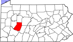 | |
| Townships | ||
| CDPs | ||
| Unincorporated communities | ||
| Counties |  Map of the Pittsburgh Tri-State with green counties in the metropolitan area and yellow counties in the combined area. | |
|---|---|---|
| Major cities | ||
| Cities and towns 15k-50k (in 2010) | ||
| Airports | ||
| Topics | ||
| ||