Ernest, Pennsylvania
| Ernest, Pennsylvania | |
|---|---|
| Borough | |
 Ernest, Pennsylvania | |
| Coordinates: 40°40′39″N 79°09′51″W / 40.67750°N 79.16417°WCoordinates: 40°40′39″N 79°09′51″W / 40.67750°N 79.16417°W | |
| Country | United States |
| State | Pennsylvania |
| County | Indiana |
| Government | |
| • Type | Borough Council |
| Area | |
| • Total | 0.2 sq mi (0.5 km2) |
| Population (2010) | |
| • Total | 462 |
| • Density | 2,134.6/sq mi (824.2/km2) |
| Time zone | Eastern (EST) (UTC-5) |
| • Summer (DST) | EDT (UTC-4) |
| Zip code | 15739 |
Ernest is a borough in Indiana County, Pennsylvania, United States. The population was 462 at the 2010 census.
History
A post office called Ernest was established in 1903, and remained in operation until 1973.[1] The origin of the name Ernest is obscure.[2]
Geography
Ernest is located at 40°40′39″N 79°09′51″W / 40.677609°N 79.164228°W.[3]
According to the United States Census Bureau, the borough has a total area of 0.2 square miles (0.52 km2), all of it land.
Demographics
| Historical population | |||
|---|---|---|---|
| Census | Pop. | %± | |
| 1980 | 584 | — | |
| 1990 | 492 | −15.8% | |
| 2000 | 501 | 1.8% | |
| 2010 | 462 | −7.8% | |
| Est. 2015 | 448 | [4] | −3.0% |
| Sources:[5][6][7] | |||
As of the census[6] of 2000, there were 501 people, 208 households, and 122 families residing in the borough. The population density was 2,134.6 people per square mile (841.0/km2). There were 221 housing units at an average density of 941.6 per square mile (371.0/km2). The racial makeup of the borough was 97.41% White, 1.00% African American, 0.40% Native American, 0.20% Asian, 0.40% from other races, and 0.60% from two or more races. Hispanic or Latino of any race were 0.80% of the population.
There were 208 households, out of which 30.8% had children under the age of 18 living with them, 43.3% were married couples living together, 10.6% had a female householder with no husband present, and 41.3% were non-families. 35.1% of all households were made up of individuals, and 23.6% had someone living alone who was 65 years of age or older. The average household size was 2.41 and the average family size was 3.18.
In the borough the population was spread out, with 26.9% under the age of 18, 8.4% from 18 to 24, 28.1% from 25 to 44, 19.6% from 45 to 64, and 17.0% who were 65 years of age or older. The median age was 36 years. For every 100 females there were 91.2 males. For every 100 females age 18 and over, there were 87.7 males.
The median income for a household in the borough was $21,058, and the median income for a family was $28,214. Males had a median income of $23,438 versus $17,125 for females. The per capita income for the borough was $10,951. About 16.7% of families and 19.8% of the population were below the poverty line, including 31.5% of those under age 18 and 15.9% of those age 65 or over.
Notable natives
- Bernice Gera, first female umpire in a professional baseball.
References
- ↑ "Indiana County". Jim Forte Postal History. Retrieved 20 May 2015.
- ↑ Baker, Lawrence B. (Jul 14, 1969). "Rodney, Oscar, Cecil, Esther Surround Us". Pittsburgh Post-Gazette. p. 23. Retrieved 20 May 2015.
- ↑ "US Gazetteer files: 2010, 2000, and 1990". United States Census Bureau. 2011-02-12. Retrieved 2011-04-23.
- ↑ "Annual Estimates of the Resident Population for Incorporated Places: April 1, 2010 to July 1, 2015". Retrieved July 2, 2016.
- ↑ "Census of Population and Housing". U.S. Census Bureau. Retrieved 11 December 2013.
- 1 2 "American FactFinder". United States Census Bureau. Retrieved 2008-01-31.
- ↑ "Incorporated Places and Minor Civil Divisions Datasets: Subcounty Resident Population Estimates: April 1, 2010 to July 1, 2012". Population Estimates. U.S. Census Bureau. Retrieved 11 December 2013.
Municipalities and communities of Indiana County, Pennsylvania, United States | ||
|---|---|---|
| Boroughs | 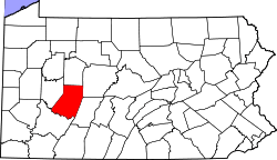 | |
| Townships | ||
| CDPs | ||
| Unincorporated communities | ||
| Counties |  Map of the Pittsburgh Tri-State with green counties in the metropolitan area and yellow counties in the combined area. | |
|---|---|---|
| Major cities | ||
| Cities and towns 15k-50k (in 2010) | ||
| Airports | ||
| Topics | ||
| ||