Salem Township, Columbiana County, Ohio
| Salem Township, Columbiana County, Ohio | |
|---|---|
| Township | |
|
| |
 Location of Salem Township in Columbiana County | |
| Coordinates: 40°52′28″N 80°46′41″W / 40.87444°N 80.77806°WCoordinates: 40°52′28″N 80°46′41″W / 40.87444°N 80.77806°W | |
| Country | United States |
| State | Ohio |
| County | Columbiana |
| Area | |
| • Total | 31.2 sq mi (80.9 km2) |
| • Land | 31.2 sq mi (80.7 km2) |
| • Water | 0.08 sq mi (0.2 km2) |
| Elevation[1] | 1,001 ft (305 m) |
| Population (2010) | |
| • Total | 5,484 |
| • Density | 176/sq mi (68.0/km2) |
| Time zone | Eastern (EST) (UTC-5) |
| • Summer (DST) | EDT (UTC-4) |
| ZIP code | 44460 |
| Area code(s) | 330, 234 |
| FIPS code | 39-69848[2] |
| GNIS feature ID | 1085902[1] |
Salem Township is one of the eighteen townships of Columbiana County, Ohio, United States. The 2010 census reported 5,484 people living in the township,[3] 3,170 of whom were in the unincorporated portions of the township.[4]
Geography
Located in the northern part of the county, it borders the following townships:
- Green Township, Mahoning County - north
- Beaver Township, Mahoning County - northeast corner
- Fairfield Township - east
- Elkrun Township - southeast corner
- Center Township - south
- Hanover Township - southwest corner
- Butler Township - west
- Perry Township - northwest
Parts of the villages of Leetonia and Washingtonville are located in northeastern and northern Salem Township. A small portion of the city of Salem is in the northwest corner of the township.
Name and history
It is one of fourteen Salem Townships statewide.[5]
The township was among the first organized in the county in 1803.[6]
Government
The township is governed by a three-member board of trustees, who are elected in November of odd-numbered years to a four-year term beginning on the following January 1. Two are elected in the year after the presidential election and one is elected in the year before it. There is also an elected township fiscal officer,[7] who serves a four-year term beginning on April 1 of the year after the election, which is held in November of the year before the presidential election. Vacancies in the fiscal officership or on the board of trustees are filled by the remaining trustees.
References
- 1 2 "US Board on Geographic Names". United States Geological Survey. 2007-10-25. Retrieved 2008-01-31.
- ↑ "American FactFinder". United States Census Bureau. Retrieved 2008-01-31.
- ↑ "Geographic Identifiers: 2010 Demographic Profile Data (G001): Salem township, Columbiana County, Ohio". U.S. Census Bureau, American Factfinder. Retrieved January 28, 2015.
- ↑ "Geographic Identifiers: 2010 Demographic Profile Data (G001): Remainder of Salem township, Salem township, Columbiana County, Ohio". U.S. Census Bureau, American Factfinder. Retrieved January 28, 2015.
- ↑ "Detailed map of Ohio" (PDF). United States Census Bureau. 2000. Retrieved 2007-02-16.
- ↑ Cranmer, Gibson Lamb (1891). History of the upper Ohio Valley. 2. Madison, Wisconsin: Brant & Fuller. p. 22.
- ↑ §503.24, §505.01, and §507.01 of the Ohio Revised Code. Accessed 4/30/2009.
External links
Municipalities and communities of Columbiana County, Ohio, United States | ||
|---|---|---|
| Cities | 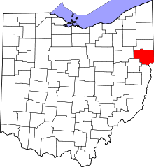 | |
| Villages | ||
| Townships | ||
| CDPs | ||
| Unincorporated communities |
| |
| Ghost town | ||
| Footnotes | ‡This populated place also has portions in an adjacent county or counties | |