Homeworth, Ohio
| Homeworth, Ohio | |
|---|---|
| Census-designated place | |
 Homeworth | |
| Coordinates: 40°50′7″N 81°4′2″W / 40.83528°N 81.06722°WCoordinates: 40°50′7″N 81°4′2″W / 40.83528°N 81.06722°W | |
| Country | United States |
| State | Ohio |
| County | Columbiana |
| Township | Knox |
| Area | |
| • Total | 1.25 sq mi (3.25 km2) |
| • Land | 1.24 sq mi (3.21 km2) |
| • Water | 0.02 sq mi (0.04 km2) |
| Elevation[1] | 1,140 ft (350 m) |
| Population (2010) | |
| • Total | 481 |
| • Density | 388/sq mi (149.9/km2) |
| Time zone | Eastern (EST) (UTC-5) |
| • Summer (DST) | EDT (UTC-4) |
| ZIP code | 44634 |
| Area code(s) | 330, 234 |
| FIPS code | 39-36176[2] |
| GNIS feature ID | 1064857[1] |
Homeworth is a census-designated place in Knox Township, Columbiana County, Ohio, United States.[3] Although it is unincorporated, Homeworth has a post office with the ZIP code of 44634. The population was 481 as of the 2010 census.[4]
History
Settlement began at what is now Homeworth about 1840.[5] Homeworth was platted in 1851 when the Cleveland and Pittsburgh Railroad was extended to that point.[6] Early variant names were Winchester and Sandy.[6] A post office called Sandy was established in 1830, and the name was changed to Homeworth in 1869.[7]
Geography
Homeworth is located in northwestern Columbiana County, in the southwestern part of Knox Township. It is located in the valley of Middle Sandy Creek near its headwaters. Its elevation is 1,155 feet (352 m) above sea level. The city of Alliance is 7 miles (11 km) to the northwest. Salem is 12 miles (19 km) to the northeast, and Canton is 18 miles (29 km) to the west.
According to the U.S. Census Bureau, the Homeworth CDP has a total area of 1.25 square miles (3.25 km2), of which 1.24 square miles (3.21 km2) is land and 0.02 square miles (0.04 km2), or 1.18%, is water.[4]
Notable residents
- Wesley Matthias Stanford (b. 1846), bishop of the United Evangelical Church
References
- 1 2 "US Board on Geographic Names". United States Geological Survey. 2007-10-25. Retrieved 2008-01-31.
- ↑ "American FactFinder". United States Census Bureau. Retrieved 2008-01-31.
- ↑ U.S. Geological Survey Geographic Names Information System: Homeworth, Ohio
- 1 2 "Geographic Identifiers: 2010 Demographic Profile Data (G001): Homeworth CDP, Ohio". U.S. Census Bureau, American Factfinder. Retrieved January 23, 2015.
- ↑ McCord, William B. (1905). History of Columbiana County, Ohio and Representative Citizens. Biographical Publishing Company. p. 284.
- 1 2 History of Columbiana County, Ohio: With Illustrations and Biographical Sketches of Some of Its Prominent Men and Pioneers. Unigraphic. 1879. p. 171.
- ↑ "Columbiana County". Jim Forte Postal History. Retrieved 10 January 2016.
Municipalities and communities of Columbiana County, Ohio, United States | ||
|---|---|---|
| Cities | 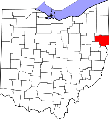 | |
| Villages | ||
| Townships | ||
| CDPs | ||
| Unincorporated communities |
| |
| Ghost town | ||
| Footnotes | ‡This populated place also has portions in an adjacent county or counties | |