East Rochester, Ohio
| East Rochester, Ohio | |
|---|---|
| Census-designated place | |
|
East Rochester Post Office | |
 Location of East Rochester, Ohio | |
| Coordinates: 40°44′45″N 81°2′4″W / 40.74583°N 81.03444°WCoordinates: 40°44′45″N 81°2′4″W / 40.74583°N 81.03444°W | |
| Country | United States |
| State | Ohio |
| County | Columbiana |
| Township | West |
| Area | |
| • Total | 0.4 sq mi (1.1 km2) |
| • Land | 0.4 sq mi (1.1 km2) |
| • Water | 0 sq mi (0 km2) |
| Elevation[1] | 1,115 ft (340 m) |
| Population (2010) | |
| • Total | 231 |
| • Density | 542/sq mi (209.3/km2) |
| Time zone | Eastern (EST) (UTC-5) |
| • Summer (DST) | EDT (UTC-4) |
| ZIP code | 44625 |
| Area code(s) | 330, 234 |
| FIPS code | 39-24024 |
| GNIS code | 1064588 |
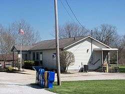
East Rochester is an unincorporated community and census-designated place (CDP) in southern West Township, Columbiana County, Ohio, United States.[2] As of the 2010 census it had a population of 231.[3] Although it is unincorporated, it has a post office, with the ZIP code of 44625.[4] It lies along U.S. Route 30.
History
East Rochester was originally known officially as "Rochester", and under the latter name was platted in 1834.[5] The Cleveland and Pittsburgh Railroad was built through the settlement in 1852.[6] When the post office was established, the name "East Rochester" was adopted to avoid repetition with another Rochester, Ohio.[7] A post office called East Rochester has been in operation since 1840.[8]
Geography
East Rochester is located along U.S. Route 30, 32 miles (51 km) northwest of East Liverpool and 22 miles (35 km) east of Canton. The nearest incorporated community is Minerva, 4 miles (6 km) to the west.
According to the U.S. Census Bureau, the East Rochester CDP has an area of 0.42 square miles (1.1 km2). It is in the valley of Sandy Creek, which flows west to the Tuscarawas River, a tributary of the Ohio River.
References
- ↑ "US Board on Geographic Names". United States Geological Survey. 2007-10-25. Retrieved 2008-01-31.
- ↑ U.S. Geological Survey Geographic Names Information System: East Rochester, Ohio
- ↑ "Geographic Identifiers: 2010 Demographic Profile Data (G001): East Rochester CDP, Ohio". U.S. Census Bureau, American Factfinder. Retrieved January 23, 2015.
- ↑ Zip Code Lookup
- ↑ Overman, William Daniel (1958). Ohio Town Names. Akron, OH: Atlantic Press. p. 41.
- ↑ McCord, William B. (1905). History of Columbiana County, Ohio and Representative Citizens. Biographical Publishing Company. p. 314.
- ↑ Mack, Horace (1879). History of Columbiana County, Ohio: With Illustrations and Biographical Sketches of Some of Its Prominent Men and Pioneers. Unigraphic. p. 291.
- ↑ "Columbiana County". Jim Forte Postal History. Retrieved 10 January 2016.
Municipalities and communities of Columbiana County, Ohio, United States | ||
|---|---|---|
| Cities | 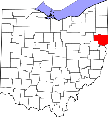 | |
| Villages | ||
| Townships | ||
| CDPs | ||
| Unincorporated communities |
| |
| Ghost town | ||
| Footnotes | ‡This populated place also has portions in an adjacent county or counties | |