Rocktram, California
| Rocktram | |
|---|---|
| unincorporated community | |
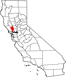
 Rocktram  Rocktram Location in California | |
| Coordinates: 38°15′27″N 122°16′50″W / 38.25750°N 122.28056°WCoordinates: 38°15′27″N 122°16′50″W / 38.25750°N 122.28056°W | |
| Country |
|
| State |
|
| County | Napa County |
| Elevation[1] | 13 ft (4 m) |
Rocktram (also, Rockfram)[2] is an unincorporated community in Napa County, California.[1] It lies at an elevation of 13 feet (4 m).[1] Rocktram is located on the Southern Pacific Railroad, 3 miles (4.8 km) south of Napa,[2] at the junction with the Napa Valley Railroad and the Basalt Rock Company rock tram. This area got its name from an overhead tramway between the Basalt Rock Company quarry and a plant located on the Napa River.[3] The tram crossed California State Route 221 near what is now Kaiser Road. Metal containers that hung from a steel cable transported rock from Basalt’s quarry on the hills east of the highway to the plant on the river. The rocks were loaded on barges and floated down to construction sites from Sacramento to San Francisco. Rocks from Basalt were used in the construction of Treasure Island and most of the Bay Area bridges.[4]
References
- 1 2 3 U.S. Geological Survey Geographic Names Information System: Rocktram, California
- 1 2 Durham, David L. (1998). California's Geographic Names: A Gazetteer of Historic and Modern Names of the State. Clovis, Calif.: Word Dancer Press. p. 691. ISBN 1-884995-14-4.
- ↑ Peter Jensen (July 13, 2013). "Mining Napa's eastern hills". Napa Valley Register. Napa Valley Publishing.
- ↑ Ford, Jim (September 14, 2009). "Yesterday's landmarks". Napa Valley Register. Napa, CA: Lee Enterprises, Inc. Retrieved August 13, 2011.