Howell Mountain, California
For the viticultural region, see Howell Mountain AVA.
| Howell Mountain | |
|---|---|
| unincorporated community | |
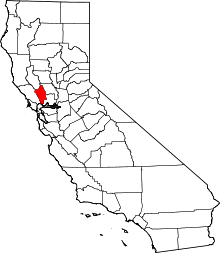
 Howell Mountain  Howell Mountain Location in California | |
| Coordinates: 38°34′53″N 122°27′04″W / 38.58139°N 122.45111°WCoordinates: 38°34′53″N 122°27′04″W / 38.58139°N 122.45111°W | |
| Country |
|
| State |
|
| County | Napa County |
| Elevation[1] | 1,683 ft (513 m) |
Howell Mountain (formerly, White Cottage)[2] is an unincorporated community in the Vaca Mountains, within Napa County, California.[1] It lies at an elevation of 1683 feet (513 m).[1]
Howell Mountain is located 5.5 miles (8.9 km) north-northeast of Saint Helena.[2]
For census purposes, it forms part of the Angwin census-designated place.[2]
References
This article is issued from Wikipedia - version of the 7/5/2016. The text is available under the Creative Commons Attribution/Share Alike but additional terms may apply for the media files.