Campvale, New South Wales
| Campvale New South Wales | |||||||||||||
|---|---|---|---|---|---|---|---|---|---|---|---|---|---|
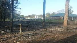 Rural properties at Campvale after the 2013 New South Wales bushfires | |||||||||||||
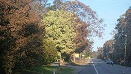 Richardson Road, the main road through Campvale after the 2013 New South Wales bushfires | |||||||||||||
|
Campvale | |||||||||||||
| Coordinates | 32°46′24″S 151°51′4″E / 32.77333°S 151.85111°ECoordinates: 32°46′24″S 151°51′4″E / 32.77333°S 151.85111°E | ||||||||||||
| Postcode(s) | 2318 | ||||||||||||
| Elevation | 5 m (16 ft)[Note 1] | ||||||||||||
| Area | 15.8 km2 (6.1 sq mi)[Note 2] | ||||||||||||
| Time zone | AEST (UTC+10) | ||||||||||||
| • Summer (DST) | AEDT (UTC+11) | ||||||||||||
| Location |
| ||||||||||||
| LGA(s) | Port Stephens Council[1] | ||||||||||||
| Region | Hunter[1] | ||||||||||||
| County | Gloucester[2] | ||||||||||||
| Parish | Stowell [2] | ||||||||||||
| State electorate(s) | Port Stephens[3] | ||||||||||||
| Federal Division(s) | Paterson[4] | ||||||||||||
| |||||||||||||
Campvale is a sparsely populated rural suburb of the Port Stephens local government area in the Hunter Region of New South Wales, Australia.[1][2][5]
Geography
Campvale is roughly rectangular in shape and consists predominantly of bushland on sandy soil. It is bisected by Richardson Road, the main east-west road between Raymond Terrace and Port Stephens. In the centre of the suburb, Medowie Road, the main south-north road connecting Williamtown, Campvale, Medowie and Ferodale to the Pacific Highway, crosses Richardson Road at the Medowie roundabout. There is only one other road in the suburb, in the northeastern corner. Adjacent to Grahamstown Dam, Grahamstown Road skirts the dam, providing access from Richardson Road to Medowie.
A small number of properties are located to the north of Richardson Road, between Grahamstown Dam and the Medowie Roundabout. This is the only populated area in the suburb.
Notes
References
- 1 2 3 "Suburb Search - Local Council Boundaries - Hunter (HT) - Port Stephens". New South Wales Division of Local Government. Archived from the original on 21 June 2014. Retrieved 20 October 2013.
- 1 2 3 "Campvale". Geographical Names Register (GNR) of NSW. Geographical Names Board of New South Wales. Retrieved 20 October 2013.
- ↑ "Port Stephens". New South Wales Electoral Commission. 11 October 2013. Retrieved 20 October 2013.
- ↑ "Paterson". Australian Electoral Commission. Retrieved 20 October 2013.
- ↑ "Campvale". Land and Property Management Authority - Spatial Information eXchange. New South Wales Land and Property Information. Retrieved 20 October 2013.
| Wikimedia Commons has media related to Campvale, New South Wales. |