Ontario Highway 26
| |||||||||||||
|---|---|---|---|---|---|---|---|---|---|---|---|---|---|
| Route information | |||||||||||||
| Maintained by the Ministry of Transportation of Ontario | |||||||||||||
| Length: | 113.7 km[1] (70.6 mi) | ||||||||||||
| Existed: | July 2, 1927[2] – present | ||||||||||||
| Major junctions | |||||||||||||
| West end: |
| ||||||||||||
|
| |||||||||||||
| East end: |
| ||||||||||||
| Location | |||||||||||||
| Major cities: | Owen Sound, Meaford, Collingwood, Wasaga Beach, Stayner, Barrie | ||||||||||||
| Highway system | |||||||||||||
| |||||||||||||
King's Highway 26, commonly referred to as Highway 26, is a provincially maintained highway in the Canadian province of Ontario, connecting the cities of Barrie and Owen Sound. Between these two cities, the highway serves the southern shoreline of Georgian Bay, passing through Stayner, Collingwood and Meaford and by the Blue Mountain Resort. In addition, the highway serves as the main route to Wasaga Beach, a popular recreational destination during the summer months.
Highway 26 was established in 1926, and has remained almost unchanged since then, with the exception of the Pretty River Parkway diversion. A new alignment of the highway between Collingwood and Stayner was opened on November 15, 2012.[3]
Route description
Highway 26 between Owen Sound and Meaford in the west is not as highly traveled as the tourist area to the east. It is also not a very straight route, as the highway makes four right-hand turns at signalled intersections, including the junction with Simcoe Road 27 (formerly Highway 27) north of Barrie (which is not signalled), the intersection with Simcoe Roads 91 and 42 in downtown Stayner (which lacks a right-hand turn lane), Hume Street in eastern Collingwood, and High street in western Collingwood. Although there is a Realignment Program currently underway.[4]
The routing of the highway takes it from the junction with Highway 6, Highway 10 and Highway 21 in Owen Sound to its terminus at Highway 400 in Barrie at the Bayfield street interchange. For a time, the highway continued southward to Dunlop street, formerly Highway 11, in Barrie, cosigned with Highway 27. The southern portion of Bayfield street was downloaded to the City of Barrie along with Dunlop street in 1997, when these sections of Highway 27 and 11 were eliminated. This shortened the highway's length by 1.3 kilometers and removed the 7.2 kilometer concurrency with Highway 27. The highway's current length is 115.7 km.
The highway serves as a major link between Barrie and the Greater Toronto Area (via Highway 400) and the popular tourist region on the southern shore of Georgian Bay. Over the past several years the popularity of this region has increased, and traffic levels have increased accordingly. Major reconstruction work was undertaken to repair the very old bridge over the Nottawasaga River in Edenvale (between Barrie and Stayner).
History
Highway 26 was first assumed by the Department of Highways on July 2, 1927 along an existing trunk route between Barrie and Owen Sound. At its western terminus, the route ended at Highway 6; the eastern terminus was at Highway 11. Since then, the route has remained almost unchanged, except in the Collingwood and Barrie areas.[2]
Prior to the completion of the Pretty River Parkway in Collingwood in the 1970s, Highway 26 was routed through Collingwood along Hume Street, before making a 90 degree right turn (north) at the intersection with Highway 24 (Now Simcoe Road 124, Hurontario Street) with which it was concurrent until Highway 24's terminus at First Street, where Highway 26 makes a 90 degree left turn (west) onto First Street, continuing on the present route. The Pretty River Parkway was a bypass of this highly congested downtown route, branching off to the north from Hume Street and swinging gradually westward along the shoreline until becoming Huron Street, which is the eastward extension of First Street beyond Hurontario. In 2003, the Pretty River Parkway was widened to two lanes by Seeley and Arnill construction in each direction to match the existing sections of Huron and First Streets, with a stretch between the Pretty River Bridge and Huron Street being divided by a small median. Upgrades to Highway 26 within the town of Collingwood are likely; when the new bypass is completed, this section will be downloaded to the town.
Within Barrie, a portion of Highway 26 was transferred to the city in 1998, truncating it at Highway 400. This former portion is now known simply as Bayfield Street.
Future
A major realignment of the highway opened on November 15, 2012, bypassing the current highway east of the town of Collingwood. The former section of highway between Collingwood and Wasaga Beach is an older and dangerous section of road(especially during the winter months), with many small intersecting streets and private residences with direct highway entrances, along with very high traffic volumes. The new alignment has the highway veer west from a point along its present route between Stayner and Wasaga Beach, and parallel the current highway until a point east the Collingwood town limits. It is believed that this section is the first part in realigning the existing highway within the Collingwood area, including a bypass of the town itself, but no other projects or studies are underway that would expand this highway beyond its current length. The new route is designed as a limited access highway, and is a 4-lane divided roadway with two roundabouts: one at Mosely Street in Wasaga Beach, and the other at Poplar Sideroad in Collingwood. The former route of Highway 26 has been renamed as Beachwood Road from Collingwood to Mosely Street in Wasaga Beach. The remaining section of the former alignment south of Mosely Street has been renamed Lyons Court.[5]
Major intersections
The following table lists the major junctions along Highway 26, as noted by the Ministry of Transportation of Ontario.[1]
| Division | Location | km[1] | mi | Destinations | Notes |
|---|---|---|---|---|---|
| Grey | Owen Sound | 0.0 | 0.0 | Beginning of Owen Sound Connecting Link agreement | |
| 1.7 | 1.1 | 14th Avenue | End of Owen Sound Connecting Link agreement | ||
| Meaford | 26.7– 30.0 | 16.6– 18.6 | Meaford Connecting Link agreement | ||
| Thornbury | 39.8 | 24.7 | Peel Street | Beginning of Thornbury Connecting Link agreement | |
| 42.4 | 26.3 | End of Thornbury Connecting Link agreement | |||
| Craigleith | 52.7 | 32.7 | County Road 19 | ||
| The Blue Mountains–Clearview boundary | 55.5 | 34.5 | County Road 21/County Road 34 (Osler Bluff Road) | Beginning of Collingwood Connecting Link agreement | |
| Simcoe | |||||
| Collingwood | 62.4 | 38.8 | Hurontario Street (To | Formerly Highway 24 | |
| 66.8 | 41.5 | End of Collingwood Connecting Link agreement | |||
| Wasaga Beach | 72.9 | 45.3 | County Road 92 east (Mosley Street) | Formerly Highway 92 | |
| Stayner | 77.0 | 47.8 | Town limits; beginning of Stayner Connecting Link agreement | ||
| County Road 91 west | Formerly Highway 91 | ||||
| 79.7 | 49.5 | Mowat Street | End of Stayner Connecting Link agreement | ||
| Sunnidale Corners | 85.4 | 53.1 | |||
| Springwater | 98.6 | 61.3 | County Road 22 east (Horseshoe Valley Road) – Horseshoe Valley | ||
| Midhurst | 110.2 | 68.5 | Formerly Highway 27, which also travelled south concurrently into Barrie with Highway 26 | ||
| Barrie | 113.7 | 70.6 | Northern city limits; end of Highway 26 | ||
| Highway 26 continues south as Bayfield Street | |||||
| Barrie | 116.0 | 72.1 | Transferred to City of Barrie in 1998 | ||
| 117.4 | 72.9 | ||||
1.000 mi = 1.609 km; 1.000 km = 0.621 mi
| |||||
Gallery
-
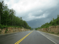
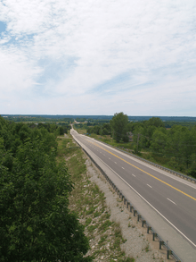
A large valley between Owen Sound and Meaford
-
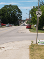
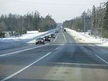
Highway 26 facing north through Meaford
-
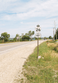
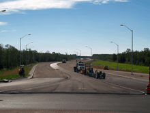
Highway 26 serves the southern shoreline of Georgian Bay, but seldom comes within eyesight of it. This section southeast of Thornbury is one of the few exceptions.
References
- 1 2 3 Ministry of Transportation of Ontario (2008). "Annual Average Daily Traffic (AADT) counts". Retrieved February 3, 2012.
- 1 2 "Appendix 6 - Schedule of Assumptions and Reversions of Sections". Annual Report (Report). Department of Highways. March 31, 1928. pp. 59–60.
- ↑ Gennings, Michael (November 15, 2012). "New Section of Highway 26 Open". Metroland Media. Retrieved November 18, 2012.
- ↑ Ministry of Transportation (April 11, 2003). "Eves Government Invests to Realign Highway 26 in Collingwood Area". Canada NewsWire. Government of Ontario. Retrieved 2007-09-07.
- ↑ Ministry of Transportation. 〈=_e.html "Harris Government to Enhance Safety and Ease Congestion along Highway 26" Check
|url=value (help). Canada NewsWire. Government of Ontario, Canada. Retrieved 2007-09-07.