Nile, Washington
| Nile, Washington | |
|---|---|
| Unincorporated community | |
 Nile, Washington Location of Nile, Washington | |
| Coordinates: 46°49′14″N 120°56′22″W / 46.8206761°N 120.9395220°WCoordinates: 46°49′14″N 120°56′22″W / 46.8206761°N 120.9395220°W[1] | |
| Country | United States |
| State | Washington |
| County | Yakima |
| Elevation[2] | 2,005 ft (611 m) |
| Time zone | Pacific (PST) (UTC-8) |
| • Summer (DST) | PDT (UTC-7) |
| ZIP code | 98937 |
| Area code(s) | 509 |
| GNIS feature ID | 1523659[2] |
Nile is an unincorporated community in Yakima County, Washington, United States, located approximately 20 miles southwest of Ellensburg in the Nile Valley adjacent to the Naches River in the Nile Valley, near the mouth of Rattlesnake Creek
The community was established in the mid-1890s by families of James Beck, William Markle and Henry Sedge, who may have named the small valley and community Nile because of the area's fertility thought to resemble that of the Nile River Valley in Egypt. According to historian Gretta Gossett, "there is yet an alluvial plain along the river near Nile Creek which is often flooded in the spring and left with a layer of silt perhaps giving rise to the name for the Nile in Egypt."[3]
References
- ↑ "Nile". Geographic Names Information System. United States Geological Survey. Retrieved 2012-10-27.
- 1 2 "US Board on Geographic Names". United States Geological Survey. 2007-10-25. Retrieved 2008-01-31.
- ↑ "Washington Place Names database". Tacoma Public Library. Retrieved October 27, 2012.
Municipalities and communities of Yakima County, Washington, United States | ||
|---|---|---|
| Cities | 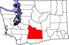 | |
| Towns | ||
| CDPs | ||
| Other unincorporated communities | ||
| Indian reservation | ||
| Footnotes | ‡This populated place also has portions in an adjacent county or counties | |
This article is issued from Wikipedia - version of the 9/5/2016. The text is available under the Creative Commons Attribution/Share Alike but additional terms may apply for the media files.