Fruitvale, Washington
| Fruitvale, Washington | |
|---|---|
| Unincorporated community | |
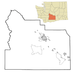 Fruitvale, Washington Location of Fruitvale, Washington | |
| Coordinates: 46°37′04″N 120°33′11″W / 46.6179041°N 120.5531223°WCoordinates: 46°37′04″N 120°33′11″W / 46.6179041°N 120.5531223°W[1] | |
| Country | United States |
| State | Washington |
| County | Yakima |
| Elevation[2] | 1,132 ft (345 m) |
| Time zone | Pacific (PST) (UTC-8) |
| • Summer (DST) | PDT (UTC-7) |
| ZIP code | 98902 |
| Area code(s) | 509 |
| GNIS feature ID | 1512229[2] |
Fruitvale is an unincorporated community in Yakima County, Washington, United States, located within the north city limits of Yakima.
The community was established around 1906 around a train station of the North Yakima and Valley Railway Company. The name was chosen because of the importance of fruit production to Yakima Valley's economy and the word 'vale' meaning valley.[3]
References
- ↑ "Fruitvale". Geographic Names Information System. United States Geological Survey. Retrieved 2012-10-27.
- 1 2 "US Board on Geographic Names". United States Geological Survey. 2007-10-25. Retrieved 2008-01-31.
- ↑ "Station Roster Master List: Fruitvale". Northern Pacific Railway Historical Association. Retrieved October 27, 2012.
Municipalities and communities of Yakima County, Washington, United States | ||
|---|---|---|
| Cities | 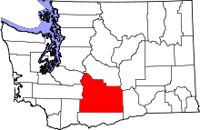 | |
| Towns | ||
| CDPs | ||
| Other unincorporated communities | ||
| Indian reservation | ||
| Footnotes | ‡This populated place also has portions in an adjacent county or counties | |
This article is issued from Wikipedia - version of the 9/5/2016. The text is available under the Creative Commons Attribution/Share Alike but additional terms may apply for the media files.