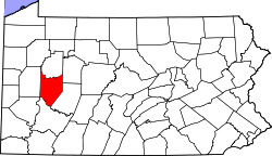
Manor Township, Armstrong County, Pennsylvania
| Manor Township, Armstrong County, Pennsylvania | |
|---|---|
| Township | |
|
| |
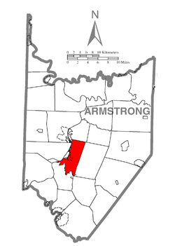 Map of Armstrong County, Pennsylvania highlighting Manor Township | |
 Map of Armstrong County, Pennsylvania | |
| Country | United States |
| State | Pennsylvania |
| County | Armstrong |
| Settled | 1769 |
| Incorporated | 1849 |
| Area | |
| • Total | 17.1 sq mi (44.4 km2) |
| • Land | 16.6 sq mi (43.0 km2) |
| • Water | 0.5 sq mi (1.4 km2) |
| Population (2010) | |
| • Total | 4,227 |
| • Density | 255/sq mi (98.4/km2) |
| Time zone | Eastern (EST) (UTC-5) |
| • Summer (DST) | EDT (UTC-4) |
| Website |
www |
Manor Township is a township in Armstrong County, Pennsylvania, United States. The population was 4,227 at the 2010 census.[1]
Geography
Manor Township is located in central Armstrong County. It is bordered to the west by the Allegheny River and by the boroughs of Ford Cliff, Ford City, and Manorville. The borough of Kittanning borders the short northwest edge of the township. Crooked Creek forms the southern border of the township,[2] and Cowanshannock Creek meanders through a small northeast section of the township.[3] Ross Island is within the township in the Allegheny River.
According to the United States Census Bureau, the township has a total area of 17.1 square miles (44.4 km2), of which 16.6 square miles (43.0 km2) is land and 0.54 square miles (1.4 km2), or 3.23%, is water.[1]
Demographics
As of the census[4] of 2000, there were 4,231 people, 1,752 households, and 1,254 families residing in the township. The population density was 254.7 people per square mile (98.4/km²). There were 1,879 housing units at an average density of 113.1/sq mi (43.7/km²). The racial makeup of the township was 98.49% White, 0.61% African American, 0.12% Native American, 0.09% Asian, 0.02% Pacific Islander, 0.09% from other races, and 0.57% from two or more races. Hispanic or Latino of any race were 0.38% of the population.
There were 1,752 households, out of which 27.5% had children under the age of 18 living with them, 60.6% were married couples living together, 7.4% had a female householder with no husband present, and 28.4% were non-families. 25.2% of all households were made up of individuals, and 13.8% had someone living alone who was 65 years of age or older. The average household size was 2.40 and the average family size was 2.87.
In the township the population was spread out, with 21.7% under the age of 18, 5.8% from 18 to 24, 26.0% from 25 to 44, 25.6% from 45 to 64, and 20.9% who were 65 years of age or older. The median age was 43 years. For every 100 females there were 94.4 males. For every 100 females age 18 and over, there were 93.2 males.
The median income for a household in the township was $34,452, and the median income for a family was $43,603. Males had a median income of $31,491 versus $22,668 for females. The per capita income for the township was $18,789. About 6.0% of families and 7.3% of the population were below the poverty line, including 10.5% of those under age 18 and 4.6% of those age 65 or over.
References
- 1 2 "Geographic Identifiers: 2010 Demographic Profile Data (G001): Manor township, Armstrong County, Pennsylvania". U.S. Census Bureau, American Factfinder. Retrieved August 1, 2013.
- ↑ "Crooked Creek". Geographic Names Information System. United States Geological Survey. Retrieved 2010-06-22.
- ↑ "Cowanshannock Creek". Geographic Names Information System. United States Geological Survey. Retrieved 2010-11-16.
- ↑ "American FactFinder". United States Census Bureau. Retrieved 2008-01-31.
External links
Municipalities and communities of Armstrong County, Pennsylvania, United States | ||
|---|---|---|
| City | | |
| Boroughs | ||
| Townships | ||
| CDPs | ||
| Unincorporated communities | ||
| Counties |  Map of the Pittsburgh Tri-State with green counties in the metropolitan area and yellow counties in the combined area. | |
|---|---|---|
| Major cities | ||
| Cities and towns 15k-50k (in 2010) | ||
| Airports | ||
| Topics | ||
| ||
Coordinates: 40°45′52″N 79°30′24″W / 40.76444°N 79.50667°W