Worthington, Pennsylvania
| Worthington, Pennsylvania | |
|---|---|
| Borough | |
|
Worthington-West Franklin Municipal Complex | |
 Worthington | |
| Coordinates: 40°50′17″N 79°37′58″W / 40.83806°N 79.63278°WCoordinates: 40°50′17″N 79°37′58″W / 40.83806°N 79.63278°W | |
| Country | United States |
| State | Pennsylvania |
| County | Armstrong |
| Settled | 1811 |
| Incorporated | 1855 |
| Government | |
| • Type | Borough council |
| Area | |
| • Total | 0.7 sq mi (1.8 km2) |
| • Land | 0.7 sq mi (1.8 km2) |
| • Water | 0 sq mi (0 km2) |
| Elevation | 1,120 ft (340 m) |
| Population (2010) | |
| • Total | 639 |
| • Density | 929/sq mi (358.8/km2) |
| Time zone | Eastern (EST) (UTC-5) |
| • Summer (DST) | EDT (UTC-4) |
| Zip code | 16262 |

Worthington is a borough in Armstrong County, Pennsylvania, United States. The population was 639 at the 2010 census.[1]
History
Worthington was laid out on a tract of land called Mt. Lorenzo by Judge James Barr in 1843-1844. He chose the location due to the nearby junction of two important early stage coach routes, the east-west route from Indiana, Pennsylvania, to Butler, and the north-south route from Freeport to Emlenton. It was incorporated as a borough in 1855. As the village grew into a town it variously relied upon farming and light manufacturing for its income. During the 1970s most manufacturing ceased. Agriculture is still important to the region, and a few light tool and die firms survive. The region also features coal, natural gas, and mineral extraction. In the 19th century an iron furnace and woolen mill were the main industrial operations, both owned and operated by Peter Graff I.
The town's first settlers were a mix of eastern Pennsylvanians and newly arrived immigrants of Scotch-Irish, German and English background. Other ethnic groups would arrive in the early 20th century in small numbers. Other later industries included tile block and clay drain pipe manufacturing, aluminum ladder and specialty tool and die production, limestone mining, and underground mushroom farming. The town hosts several merchants including the Worthington Hardware, Cade's Tomato Pies, Carlesi's Restaurant, Moonlight Credit Union, Wo-Town Market (formerly Long's Market) and Bowser's Feed Store, four Protestant churches, a community park, several civic organizations (including a public library), and a community center and municipal complex housed in the former Junior/Senior High School. The fire hall serves both Worthington borough and West Franklin Township
Geography
Worthington is located in western Armstrong County at 40°50′17″N 79°37′58″W / 40.838123°N 79.632685°W.[2] U.S. Route 422, the four-lane Benjamin Franklin Highway, passes through the borough south of its center, leading east 7 miles (11 km) to Kittanning and west 15 miles (24 km) to Butler. The borough extends west into the valley of Buffalo Creek, a tributary of the Allegheny River.
According to the United States Census Bureau, the borough has a total area of 0.69 square miles (1.8 km2), all of it land.[1]
Demographics
| Historical population | |||
|---|---|---|---|
| Census | Pop. | %± | |
| 1860 | 213 | — | |
| 1870 | 216 | 1.4% | |
| 1880 | 186 | −13.9% | |
| 1890 | 246 | 32.3% | |
| 1900 | 398 | 61.8% | |
| 1910 | 436 | 9.5% | |
| 1920 | 440 | 0.9% | |
| 1930 | 661 | 50.2% | |
| 1940 | 600 | −9.2% | |
| 1950 | 800 | 33.3% | |
| 1960 | 772 | −3.5% | |
| 1970 | 816 | 5.7% | |
| 1980 | 760 | −6.9% | |
| 1990 | 713 | −6.2% | |
| 2000 | 778 | 9.1% | |
| 2010 | 639 | −17.9% | |
| Est. 2015 | 614 | [3] | −3.9% |
| Sources:[4][5][6] | |||
As of the census[5] of 2000, there were 778 people, 307 households, and 212 families residing in the borough. The population density was 1,380.4 people per square mile (536.4/km2). There were 319 housing units at an average density of 566.0 per square mile (219.9/km2). The racial makeup of the borough was 99.10% White, 0.26% African American, 0.13% Asian, 0.13% from other races, and 0.39% from two or more races. Hispanic or Latino of any race were 0.26% of the population.
There were 307 households, out of which 29.3% had children under the age of 18 living with them, 56.7% were married couples living together, 9.4% had a female householder with no husband present, and 30.9% were non-families. 26.4% of all households were made up of individuals, and 12.1% had someone living alone who was 65 years of age or older. The average household size was 2.43 and the average family size was 2.91.
In the borough the population was spread out, with 22.2% under the age of 18, 7.8% from 18 to 24, 26.6% from 25 to 44, 26.9% from 45 to 64, and 16.5% who were 65 years of age or older. The median age was 40 years. For every 100 females there were 90.7 males. For every 100 females age 18 and over, there were 92.7 males.
The median income for a household in the borough was $31,000, and the median income for a family was $37,292. Males had a median income of $27,443 versus $21,818 for females. The per capita income for the borough was $15,122. About 2.9% of families and 9.2% of the population were below the poverty line, including 7.0% of those under age 18 and 7.8% of those age 65 or over.
References
- 1 2 "Geographic Identifiers: 2010 Demographic Profile Data (G001): Worthington borough, Pennsylvania". U.S. Census Bureau, American Factfinder. Retrieved July 31, 2013.
- ↑ "US Gazetteer files: 2010, 2000, and 1990". United States Census Bureau. 2011-02-12. Retrieved 2011-04-23.
- ↑ "Annual Estimates of the Resident Population for Incorporated Places: April 1, 2010 to July 1, 2015". Retrieved July 2, 2016.
- ↑ "Census of Population and Housing". U.S. Census Bureau. Retrieved 11 December 2013.
- 1 2 "American FactFinder". United States Census Bureau. Retrieved 2008-01-31.
- ↑ "Incorporated Places and Minor Civil Divisions Datasets: Subcounty Resident Population Estimates: April 1, 2010 to July 1, 2012". Population Estimates. U.S. Census Bureau. Retrieved 11 December 2013.
Municipalities and communities of Armstrong County, Pennsylvania, United States | ||
|---|---|---|
| City | 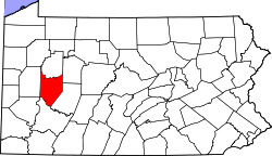 | |
| Boroughs | ||
| Townships | ||
| CDPs | ||
| Unincorporated communities | ||
| Counties |  Map of the Pittsburgh Tri-State with green counties in the metropolitan area and yellow counties in the combined area. | |
|---|---|---|
| Major cities | ||
| Cities and towns 15k-50k (in 2010) | ||
| Airports | ||
| Topics | ||
| ||