Glenrio, New Mexico and Texas
| Glenrio, New Mexico Glenrio, Texas | |
|---|---|
| Unincorporated comumunity | |
|
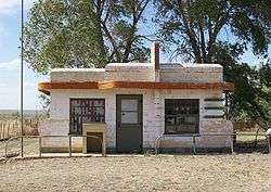
Closed café in Glenrio | |
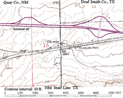 Topographic map of Glenrio, 1982 | |
| Country | United States |
| State |
New Mexico Texas |
| Counties |
Quay County, New Mexico Deaf Smith County, Texas |
| ZIP Code | 88434 |
|
Glenrio Historic District | |
 Glenrio Historic District  Glenrio Historic District | |
| Location | Texas State Highway Loop 504/New Mexico State Road 1578, Glenrio |
| Coordinates | 35°10′44″N 103°02′32″W / 35.17889°N 103.04222°WCoordinates: 35°10′44″N 103°02′32″W / 35.17889°N 103.04222°W |
| Area | 31.7 acres (12.8 ha) |
| Built | 1926 |
| Architectural style | Bungalow/Craftsman, Moderne |
| MPS | Route 66 in Texas MPS, Route 66 through New Mexico MPS |
| NRHP Reference # | 06001258 and 06001259[1] |
| NMSRCP # | 1890 |
| Significant dates | |
| Added to NRHP | January 17, 2007 |
| Designated NMSRCP | April 7, 2006 |
Glenrio, formerly Rock Island,[2] is an unincorporated community in both Deaf Smith County, Texas, and Quay County, New Mexico, in the United States. Located on Route 66, the ghost town sits on the Texas/New Mexico state line. It includes the Glenrio Historic District which was listed on the National Register of Historic Places in 2007.
The community was founded in 1903 as a railroad siding on the Rock Island Railroad. Its name is derived from Scots "glen" + Spanish "rio" (meaning "river").
History
Originally a railroad town, the village was renamed from Rock Island to Glenrio by the Rock Island and Pacific Railroad in 1908 and began receiving motorists on the dusty Ozark Trail in 1917. Its original structures were adobe buildings. The circa-1910 Angel House was in New Mexico.
The Ozark Trail was formed into U.S. Route 66 on November 11, 1926. By the 1930s, U.S. Route 66 in Texas was a paved two-lane road served locally by several filling stations, a restaurant, and a motel. The road was widened in the 1950s. A Texaco station (1950) and a diner (Brownlee Diner/Little Juarez Café, 1952) were constructed in Texas using the art moderne architectural style.[3]
The location of Glenrio on Texas and New Mexico's border led to some interesting business practices. At one point, all fuel was dispensed in Texas due to New Mexico's higher gasoline taxes. The 1930s State Line Bar and motel were built in New Mexico because Deaf Smith County, Texas, was dry at the time.[4] The railroad station was in Texas. The local post office, built circa-1935, was in New Mexico. A water tank and windmill in New Mexico were constructed circa 1945.
The Joseph Brownlee House, constructed in Amarillo in 1930, was moved to Glenrio in 1950. Glenrio was the site of the "First Motel in Texas" / "Last Motel in Texas" (Homer Ehresman's family-run 1953 State Line Café and Gas Station and 1955 Texas Longhorn Motel, closed in 1976) and other businesses which straddled the state line on U.S. Route 66 for many years until Interstate 40 bypassed the community in September 1973.[3]
Three filling stations (the 1925 Broyles Mobil station, a circa-1935 Texaco, and the 1946 Ferguson Gas Station) once operated in New Mexico.
For years there has been a simmering dispute over which state the east part of Glenrio is lawfully a part of: Texas or New Mexico? The straight north-south border between the two states was originally defined as the 103rd meridian, but the 1859 survey that was supposed to mark that boundary mistakenly set the border between 2.29 and 3.77 miles too far west of that line, making the current towns of Farwell, Texline and the east part of Glenrio appear to be within the State of Texas. New Mexico's short border with Oklahoma, in contrast, was surveyed on the correct meridian. New Mexico's draft constitution in 1910 stated that the border is on the 103rd meridian as intended. The disputed strip, hundreds of miles long, includes parts of valuable oilfields of the Permian Basin. A bill was passed in the New Mexico Senate to fund and file a lawsuit in the U.S. Supreme Court to recover the strip from Texas, but the bill did not become law. Today, land in the strip is included in Texas land surveys and the land and towns (the east part of Glenrio) for all purposes are taxed and governed by The State of Texas.[5]
Location
Glenrio sits just a few yards to the south of Interstate 40 at Texas exit 0 on Business I-40, a road which turns into a local gravel road at the state line. This was the original Route 66 alignment between Glenrio and San Jon until 1952 and was paved for many years until Quay County removed the paving due to maintenance costs. Mail was formerly served by a post office on the New Mexico side of the town.
The town consists of the remains of the courtyard motel and related Texas Longhorn Café and Phillips 66 service station, the post office, a few other buildings including the diner and adjacent Texaco service station, the old Route 66 roadbed, and the former roadbed of the Rock Island Railroad, whose tracks were removed in the 1980s. A few homes still exist in Glenrio; the Joseph Brownlee House and an office in the Texas Longhorn Motel were the last to be occupied.
Glenrio Historic District
Glenrio Historic District is a 31.7-acre (12.8 ha) historic district that was listed on the National Register of Historic Places in 2007.[1] At the time of the listing, the district included 12 contributing buildings and 4 other contributing structures.
Glenrio Welcome Center
On June 25, 2008, the State of New Mexico opened the Glenrio Welcome Center on Interstate 40 at the Texas state line. The center includes such things as a pet walk, a livestock corral, wireless Internet access, a movie theater, and information kiosks. Built to accommodate one million visitors per year, it includes green features such as recycling of greywater for grounds irrigation, and a wind turbine that will generate 20 percent of the center's energy.[6][7]
In cinema
Portions of The Grapes of Wrath were filmed in Glenrio.[8] An abandoned "Glenn Rio Motel" is depicted in the town of Radiator Springs in 2006's animated film Cars, where the architectural design of Glenrio's Little Juarez Café is used for a vacant, abandoned building which eventually becomes the Racing Museum.
See also
- National Register of Historic Places listings in Quay County, New Mexico
- National Register of Historic Places listings in Deaf Smith County, Texas
References
- 1 2 National Park Service (2009-03-13). "National Register Information System". National Register of Historic Places. National Park Service.
- ↑ U.S. Geological Survey Geographic Names Information System: Glenrio, New Mexico and Texas
- 1 2 Josh Burton (2007-04-01). "Glenrio resurrected". Amarillo Globe-News. Retrieved 2012-06-23.
- ↑ "Glenrio Historic District-Route 66: A Discover Our Shared Heritage Travel Itinerary". US National Park Service. Retrieved 2012-05-04.
- ↑ Daniel Gertson. "Border War Brewing?". Retrieved 2016-09-24.
- ↑ Glenrio Welcome Center officially opened Archived July 15, 2011, at the Wayback Machine.
- ↑ "E. Coli Found at New Glenrio Welcome Center". ABQ Journal. 2008-07-03. Retrieved 2013-02-11.
- ↑ T. Lindsay Baker (2005-08-31). More Ghost Towns of Texas. ISBN 9780806137247. Retrieved 2012-06-23.
Bibliography
- Fugate, Francis L. and Roberta B. Roadside History of New Mexico. Missoula, MT: Mountain Press, 1989, p. 356. ISBN 0-87842-242-0.
External links
| Wikimedia Commons has media related to Glenrio, New Mexico and Texas. |
| Wikivoyage has a travel guide for Glenrio. |
- Glenrio, Texas from the Handbook of Texas Online
- The Grapes of Wrath revisited: Dust to dust for the ghosts of Route 66, guardian.co.uk, Chris McGreal—writer, August 28, 2009. (includes video)
- Glenrio, TX/ from the Amarillo Globe-News
Municipalities and communities of Quay County, New Mexico, United States | ||
|---|---|---|
| City | 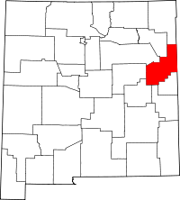 | |
| Villages | ||
| CDP | ||
| Other unincorporated communities | ||
| Footnotes | ‡This populated place also extends into Texas | |
Municipalities and communities of Deaf Smith County, Texas, United States | ||
|---|---|---|
| City | 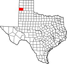 | |
| Unincorporated communities | ||
| Footnotes | ‡This populated place also extends into New Mexico | |

