Texas State Highway 70
| ||||
|---|---|---|---|---|
 | ||||
| Route information | ||||
| Maintained by TxDOT | ||||
| Length: | 315.886 mi[1] (508.369 km) | |||
| Existed: | 1926 – present | |||
| Major junctions | ||||
| South end: |
| |||
|
| ||||
| North end: |
| |||
| Location | ||||
| Counties: | Coke, Nolan, Fisher, Kent, Dickens, Motley, Hall, Briscoe, Donley, Gray, Roberts, Ochiltree | |||
| Highway system | ||||
| ||||


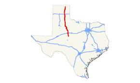
State Highway 70 (SH 70) is a state highway in Texas. The route runs approximately 315 miles (507 km) from US 277 near Blackwell to US 83 south of Perryton.[1][2][3]
Route description
SH 70 begins in far northeastern Coke County at a junction with US 277 north of Bronte.[2] The highway soon crosses into Nolan County, where it serves as the northern terminus of SH 153.[4] The first large city along SH 70's route is Sweetwater; here, the route is concurrent with Interstate 20 and US 84 along the south side of the city, between IH 20's Exits #244 and #247, before it resumes its northward course and enters Fisher County.[5] SH 70 intersects US 180 in Roby and SH 92 in Rotan.[6] Continuing north into Kent County, the route begins a concurrency with US 380 that lasts until Jayton.[7] In Dickens County, SH 70 serves as the northern terminus of SH 208 and passes through the east and north side of Spur before reaching Dickens and an intersection with US 82 / SH 114.[8][9] After heading almost due north from here, the route enters Motley County and passes through the town of Roaring Springs.[10] The next major city along the route is Matador, where SH 70 and US 70 intersect one another (along with US 62).[11] After leaving Matador, SH 70 enters Hall County, where it has a brief concurrency with SH 86 through Turkey.[12] The highway then briefly turns to the northwest and enters Briscoe County, beginning a brief concurrency with SH 256, before turning to the west and reentering Hall County; the two routes separate near the community of South Brice.[13] SH 70 resumes a more northerly path into Donley County, and has a short concurrency with US 287 through Clarendon.[14] After the two routes separate, SH 70 heads due north to a junction with Interstate 40 at its Exit #124, near the Donley–Gray County line.[15] Northbound SH 70 is concurrent with the freeway for about 3.5 mi (5.6 km) before the routes split at IH 40 Exit #121. SH 70 continues north into Pampa, where it intersects US 60 and has a half-mile duplex with SH 152. After leaving Pampa, the route turns more to the north-northeast, and enters the sparsely-populated Roberts County, where its only intersections are with a few farm to market roads that connect to the county seat of Miami.[16][17] SH 70 then enters Ochiltree County and reaches its northern terminus at US 83 south of Perryton.[3] While the current official route description of SH 70 indicates a concurrency with US 83 to a junction with SH 15 in Perryton, that roadway is presently signed only as US 83, which agrees with TxDOT's County Map Book, and signage in Perryton at the SH 15 junction with US 83 directs traffic to SH 70 using "TO SH 70" markers.[1][3]
History
SH 70 was originally designated in 1926 from Aspermont to just northeast of San Angelo along a portion of the original SH 4, which had been shifted farther east. By 1933, the route had been rerouted north to Jayton, replacing SH 161. In 1938, SH 70 was extended north from Jayton to Dickens, absorbing a portion of SH 18. Significant extension came in 1947, when SH 70 was extended to Perryton in the northern Panhandle; this was due to the realignment of US 62 between Matador and Ralls, bypassing Dickens, and the cancellation of SH 18 from Matador to Perryton.[18][19] The same year, US 277 was rerouted to a more westerly alignment between Abilene, Texas and San Angelo, Texas, and the section from just south of Blackwell to near San Angelo was transferred to that route.[1][20] In 1957, SH 70 was shifted to a more westerly alignment in Dickens, and Loop 120 was designated along the old route of SH 70 through the city.[21]
A spur, SH 70A, went from Robert Lee east to Bronte and northeast to Abilene. This route was renumbered as SH 158 by 1931.
Business route
| |
|---|---|
| Location: | Sweetwater |
| Length: | 3.788 mi[22] (6.096 km) |
| Existed: | 1990–present[22] |
SH 70 has one business route, Business SH 70-G in Sweetwater, which is a former alignment of the state highway through that city. The route was designated in 1990, when SH 70 was rerouted along the south and east side of the city to use the I-20 freeway. The business route is also concurrent with BL I-20 through downtown Sweetwater.[22][23]
Major intersections
| County | Location | mi | km | Destinations | Notes |
|---|---|---|---|---|---|
| Coke | | Southern terminus. | |||
| | |||||
| Nolan | Blackwell | ||||
| | |||||
| | |||||
| | |||||
| | |||||
| Sweetwater | South end of IH 20/US 84 concurrency, exit 244. | ||||
| North end of IH 20/US 84 concurrency, exit 247; south end of IH 20 Bus. concurrency. | |||||
| North end of IH 20 Bus. concurrency | |||||
| Fisher | | ||||
| | |||||
| Roby | |||||
| Rotan | |||||
| | |||||
| Kent | | South end of US 380 concurrency | |||
| | |||||
| Jayton | North end of US 380 concurrency | ||||
| Girard | |||||
| Dickens | | ||||
| Steele Hill | |||||
| Spur | |||||
| | |||||
| | |||||
| Dickens | |||||
| | |||||
| | |||||
| Motley | | ||||
| Roaring Springs | |||||
| | |||||
| Matador | |||||
| | |||||
| | |||||
| | |||||
| | |||||
| Hall | Turkey | South end of SH 86 concurrency | |||
| | North end of SH 86 concurrency | ||||
| Briscoe | | South end of SH 256 concurrency | |||
| Hall | South Brice | North end of SH 256 concurrency | |||
| Donley | Clarendon | South end of US 287 concurrency | |||
| North end of US 287 concurrency | |||||
| | South end of IH 40 concurrency, exit 124. | ||||
| | North end of IH 40 concurrency, exit 121. | ||||
| Gray | | ||||
| | |||||
| | |||||
| | |||||
| Pampa | |||||
| South end of SH 152 concurrency | |||||
| North end of SH 152 concurrency | |||||
| | |||||
| Roberts | | ||||
| | |||||
| Ochiltree | | ||||
| | |||||
| Ochiltree | |||||
| | Northern terminus | ||||
| 1.000 mi = 1.609 km; 1.000 km = 0.621 mi | |||||
References
- 1 2 3 4 Transportation Planning and Programming Division (n.d.). "State Highway No. 70". Highway Designation Files. Texas Department of Transportation. Retrieved April 17, 2011.
- 1 2 Transportation Planning and Programming Division (2012). Texas County Map Book (PDF) (Map) (2012 ed.). 1:120,000. Texas Department of Transportation. p. 278. OCLC 867856197. Retrieved April 17, 2011.
- 1 2 3 Transportation Planning and Programming Division (2012). Texas County Map Book (PDF) (Map) (2012 ed.). 1:120,000. Texas Department of Transportation. p. 233. OCLC 867856197. Retrieved April 17, 2011.
- ↑ Transportation Planning and Programming Division (2012). Texas County Map Book (PDF) (Map) (2012 ed.). 1:120,000. Texas Department of Transportation. p. 277. OCLC 867856197. Retrieved April 17, 2011.
- ↑ Transportation Planning and Programming Division (2012). Texas County Map Book (PDF) (Map) (2012 ed.). 1:120,000. Texas Department of Transportation. p. 276. OCLC 867856197. Retrieved April 17, 2011.
- ↑ Transportation Planning and Programming Division (2012). Texas County Map Book (PDF) (Map) (2012 ed.). 1:120,000. Texas Department of Transportation. p. 275. OCLC 867856197. Retrieved April 17, 2011.
- ↑ Transportation Planning and Programming Division (2012). Texas County Map Book (PDF) (Map) (2012 ed.). 1:120,000. Texas Department of Transportation. p. 245. OCLC 867856197. Retrieved April 17, 2011.
- ↑ Transportation Planning and Programming Division (2012). Texas County Map Book (PDF) (Map) (2012 ed.). 1:120,000. Texas Department of Transportation. p. 244. OCLC 867856197. Retrieved April 17, 2011.
- ↑ Transportation Planning and Programming Division (2012). Texas County Map Book (PDF) (Map) (2012 ed.). 1:120,000. Texas Department of Transportation. p. 243. OCLC 867856197. Retrieved April 17, 2011.
- ↑ Transportation Planning and Programming Division (2012). Texas County Map Book (PDF) (Map) (2012 ed.). 1:120,000. Texas Department of Transportation. p. 242. OCLC 867856197. Retrieved April 17, 2011.
- ↑ Transportation Planning and Programming Division (2012). Texas County Map Book (PDF) (Map) (2012 ed.). 1:120,000. Texas Department of Transportation. p. 241. OCLC 867856197. Retrieved April 17, 2011.
- ↑ Transportation Planning and Programming Division (2012). Texas County Map Book (PDF) (Map) (2012 ed.). 1:120,000. Texas Department of Transportation. p. 240. OCLC 867856197. Retrieved April 17, 2011.
- ↑ Transportation Planning and Programming Division (2012). Texas County Map Book (PDF) (Map) (2012 ed.). 1:120,000. Texas Department of Transportation. p. 239. OCLC 867856197. Retrieved April 17, 2011.
- ↑ Transportation Planning and Programming Division (2012). Texas County Map Book (PDF) (Map) (2012 ed.). 1:120,000. Texas Department of Transportation. p. 238. OCLC 867856197. Retrieved April 17, 2011.
- ↑ Transportation Planning and Programming Division (2012). Texas County Map Book (PDF) (Map) (2012 ed.). 1:120,000. Texas Department of Transportation. p. 237. OCLC 867856197. Retrieved April 17, 2011.
- ↑ Transportation Planning and Programming Division (2012). Texas County Map Book (PDF) (Map) (2012 ed.). 1:120,000. Texas Department of Transportation. p. 235. OCLC 867856197. Retrieved April 17, 2011.
- ↑ Transportation Planning and Programming Division (2012). Texas County Map Book (PDF) (Map) (2012 ed.). 1:120,000. Texas Department of Transportation. p. 234. OCLC 867856197. Retrieved April 17, 2011.
- ↑ Transportation Planning and Programming Division (n.d.). "U.S. Highway No. 62". Highway Designation Files. Texas Department of Transportation. Retrieved April 17, 2011.
- ↑ Transportation Planning and Programming Division (n.d.). "State Highway No. 18". Highway Designation Files. Texas Department of Transportation. Retrieved April 17, 2011.
- ↑ Transportation Planning and Programming Division (n.d.). "U.S. Highway No. 277". Highway Designation Files. Texas Department of Transportation. Retrieved April 17, 2011.
- ↑ Transportation Planning and Programming Division (n.d.). "State Highway Loop No. 120". Highway Designation Files. Texas Department of Transportation. Retrieved April 17, 2011.
- 1 2 3 Transportation Planning and Programming Division (n.d.). "Business State Highway No. 70-G". Highway Designation Files. Texas Department of Transportation. Retrieved April 17, 2011.
- ↑ Transportation Planning and Programming Division (n.d.). "Business Interstate Highway No. 20-M". Highway Designation Files. Texas Department of Transportation. Retrieved April 17, 2011.