Pearsall, Texas
| Pearsall, Texas | |
|---|---|
| City | |
|
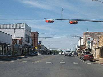
Downtown Pearsall | |
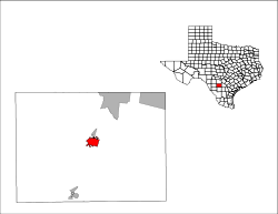 Location of Pearsall, Texas | |
| Coordinates: 28°53′29″N 99°5′42″W / 28.89139°N 99.09500°WCoordinates: 28°53′29″N 99°5′42″W / 28.89139°N 99.09500°W | |
| Country | United States |
| State | Texas |
| County | Frio |
| Area | |
| • Total | 5.95 sq mi (15.41 km2) |
| • Land | 5.93 sq mi (15.37 km2) |
| • Water | 0.02 sq mi (0.04 km2) |
| Elevation | 633 ft (193 m) |
| Population (2010) | |
| • Total | 9,146 |
| • Density | 1,541/sq mi (595.1/km2) |
| Time zone | Central (CST) (UTC-6) |
| • Summer (DST) | CDT (UTC-5) |
| ZIP code | 78061 |
| Area code(s) | 830 |
| FIPS code | 48-56384[1] |
| GNIS feature ID | 1364941[2] |
| Website |
cityofpearsall |
Pearsall (/ˈpɪərsɔːl/ PIERCE-all) is a city in and the county seat of Frio County, Texas, United States.[3] The population was 9,146 at the 2010 census,[4] up from 7,157 at the 2000 census.
Geography
Pearsall is located near the center of Frio County at 28°53′29″N 99°5′42″W / 28.89139°N 99.09500°W (28.891458, -99.094873).[5] Interstate 35 bypasses the city on the west side, with access from Exits 99, 101, and 104. I-35 leads northeast 55 miles (89 km) to San Antonio and south 100 miles (160 km) to Laredo.
According to the United States Census Bureau, Pearsall has a total area of 5.9 square miles (15.4 km2), of which 0.02 square miles (0.04 km2), or 0.27%, is water.[4]
In 2003, Pearsall annexed the unincorporated neighborhood of West Pearsall, increasing the population of the town by about 350 people.[6]
Northwest of Pearsall is the ghost town of "Frio Town", the site of a 1958 episode, "Friotown", of the ABC/Warner Brothers western television series Texas John Slaughter, with Tom Tryon in the title role. Prior to 1886, the community was known as "Frio City".[7]
Climate
The climate in this area is characterized by hot, humid summers and generally mild to cool winters. According to the Köppen Climate Classification system, Pearsall has a humid subtropical climate, abbreviated "Cfa" on climate maps.[8]
Demographics
| Historical population | |||
|---|---|---|---|
| Census | Pop. | %± | |
| 1890 | 766 | — | |
| 1910 | 1,799 | — | |
| 1920 | 2,161 | 20.1% | |
| 1930 | 2,536 | 17.4% | |
| 1940 | 1,198 | −52.8% | |
| 1950 | 2,029 | 69.4% | |
| 1960 | 3,470 | 71.0% | |
| 1970 | 5,545 | 59.8% | |
| 1980 | 7,383 | 33.1% | |
| 1990 | 6,924 | −6.2% | |
| 2000 | 7,157 | 3.4% | |
| 2010 | 9,146 | 27.8% | |
| Est. 2015 | 9,980 | [9] | 9.1% |
As of the census[1] of 2000, 7,157 people reside in Pearsall with 2,201 households, and 1,688 families residing in the city. The population density was 1,694.7 people per square mile (654.8/km²). There were 2,470 housing units at an average density of 584.9/sq mi (226.0/km²). The racial makeup of the city was 73.80% White, 0.39% African American, 0.71% Native American, 0.28% Asian, 0.01% Pacific Islander, 22.01% from other races, and 2.79% from two or more races. 84.24% of the population were Hispanic or Latino of any race.
There were 2,201 households out of which 41.4% had children under the age of 18 living with them, 53.1% were married couples living together, 18.2% had a female householder with no husband present, and 23.3% were non-families. 20.8% of all households were made up of individuals and 9.9% had someone living alone who was 65 years of age or older. The average household size was 2.99 and the average family size was 3.47.
In the city the population was spread out with 30.6% under the age of 18, 10.4% from 18 to 24, 26.9% from 25 to 44, 19.7% from 45 to 64, and 12.4% who were 65 years of age or older. The median age was 31 years. For every 100 females there were 102.6 males. For every 100 females age 18 and over, there were 103.2 males.
The median income for a household in the city was $21,602, and the median income for a family was $23,470. Males had a median income of $21,295 versus $14,720 for females. The per capita income for the city was $13,383. 35.0% of the population and 30.4% of families were below the poverty line. 43.2% of those under the age of 18 and 40.0% of those 65 and older were living below the poverty line.
Government and infrastructure
The United States Postal Service operates the Pearsall Post Office.[11]
The U.S. Immigration and Customs Enforcement operates the South Texas Detention Facility in an unincorporated area in Frio County near Pearsall.[12]
Education
Pearsall Independent School District has four schools - Ted Flores Elementary, Pearsall Intermediate, Pearsall Junior High, and Pearsall High School.
Notable people
- Alfred Allee, a famed 19th century peace officer, at one time a deputy sheriff in Pearsall
- Gene Bailey, baseball player
- George Strait, country music singer, born in Poteet, Texas, but raised in Pearsall
- Dave Studdard, professional football player, Denver Broncos (1979-1988)[13]
- Brad Wright, head football coach at Texas State University-San Marcos from 2007 to 2010, born in Pearsall in 1959
Gallery
_Town_Hall_IMG_0479.JPG) Pearsall Town Hall
Pearsall Town Hall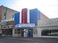 Oaks Theater on Oak Street
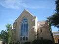 First United Methodist located across from the courthouse
 First Baptist Church of Pearsall located at Walnut and San Marcos streets
 Best Western
References
- 1 2 "American FactFinder". United States Census Bureau. Retrieved 2008-01-31.
- ↑ "US Board on Geographic Names". United States Geological Survey. 2007-10-25. Retrieved 2008-01-31.
- ↑ "Find a County". National Association of Counties. Archived from the original on May 31, 2011. Retrieved 2011-06-07.
- 1 2 "Geographic Identifiers: 2010 Demographic Profile Data (G001): Pearsall city, Texas". U.S. Census Bureau, American Factfinder. Retrieved September 7, 2016.
- ↑ "US Gazetteer files: 2010, 2000, and 1990". United States Census Bureau. 2011-02-12. Retrieved 2011-04-23.
- ↑ US Census change list
- ↑ Billy Hathorn, "Roy Bean, Temple Houston, Bill Longley, Ranald Mackenzie, Buffalo Bill, Jr., and the Texas Rangers: Depictions of West Texans in Series Television, 1955 to 1967", West Texas Historical Review, Vol. 89 (2013), p. 116
- ↑ Climate Summary for Pearsall, Texas
- ↑ "Annual Estimates of the Resident Population for Incorporated Places: April 1, 2010 to July 1, 2015". Retrieved July 2, 2016.
- ↑ "Census of Population and Housing". Census.gov. Archived from the original on May 11, 2015. Retrieved June 4, 2015.
- ↑ "Post Office Location - PEARSALL." United States Postal Service. Retrieved on May 22, 2010.
- ↑ "South Texas Detention Facility." U.S. Immigration and Customs Enforcement. Retrieved on May 22, 2010.
- ↑ NFL.com Player Profile
External links
- City of Pearsall official website
- LoneStar Internet: Pearsall, Texas, very brief history
- Handbook of Texas Online: Pearsall, Texas
Municipalities and communities of Frio County, Texas, United States | ||
|---|---|---|
| Cities | 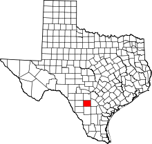 | |
| CDPs | ||
| Ghost towns | ||
