Interstate 35E (Texas)
| ||||
|---|---|---|---|---|
| Stemmons Freeway | ||||
.svg.png) | ||||
| Route information | ||||
| Maintained by TxDOT | ||||
| Length: | 96.76 mi[1] (155.72 km) | |||
| Major junctions | ||||
| South end: |
| |||
|
| ||||
| North end: |
| |||
| Location | ||||
| Counties: | Hill, Ellis, Dallas, Denton | |||
| Highway system | ||||
| ||||

Interstate 35E (I-35E), an Interstate Highway, is the eastern half of I-35 where it splits to serve the Dallas/Fort Worth metropolitan area. I-35 splits into two branch routes, I-35W and I-35E at Hillsboro. I-35E travels northward for 97 miles (156 km), maintaining I-35's sequence of exit numbers. It travels through Dallas before rejoining with I-35W to reform I-35 in Denton. This is one of two points where I-35 splits into suffixed pairs of Interstate highways to service a metropolitan area, doing the same thing in Minneapolis/St. Paul, Minnesota.
Historically, other interstates were given directional suffixes. On every other interstate, the directional suffixes were phased out by giving the route a loop or spur designation (such as I-270 in Maryland, which was once I-70S), or in some cases were assigned a different route number (such as I-76, which was once I-80S). In the case of I-35, since both branches return to a unified interstate beyond the twin cities of Dallas and Fort Worth, the AASHTO committees allowed the suffixes to remain.

Route description
Concurrent routes
U.S. Highway 67
Interstate 35E travels concurrently with U.S. Route 67 (US 67) from just north of Kiest Boulevard in the Oak Cliff area of Dallas to the I-30 interchange in downtown Dallas. From there, US 67 joins with I-30. On both segments, US 67 is signed.
U.S. Highway 77
From Waco, Texas to El Dorado, Kansas, I-35 (or I-35E) typically runs concurrent with, or lies fairly close to, US 77. This highway travels parallel to I-35E after splitting off of I-35 north of Hillsboro, running through Italy and Milford. It joins with I-35E for less than 1 mile (1.6 km) just south of Waxahachie, before splitting back off to run through Waxahachie. It rejoins the interstate just north of a junction with State Highway 342 in Red Oak. US 77 stays with the interstate through Dallas and up to the southeastern section of Denton. It then breaks off, rejoining I-35 north of the city. Except for the spur sections (Denton and the section between Red Oak and Hillsboro), US 77 is unsigned.
From the Dallas–Ellis county line to Denton
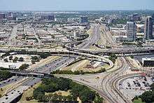
From the Dallas–Ellis County line to downtown Dallas, I-35E is called South R.L. Thornton Freeway and varies from eight to ten lanes plus HOV. The section from I-20 to Downtown Dallas will be undergoing a major reconstruction by 2015 to 12 lanes. Reconstruction of I-35E and the downtown Mixmaster interchange with I-30 is planned as part of the Horseshoe project,[2] derived from the larger Pegasus Project.[3][4] From this point, I-35E is named the Stemmons Freeway to Lewisville. This section will undergo reconstruction in three phases. The first, a widening of I-35E from I-635 to Denton, will start in late 2011 to over 16 lanes. The second, the LBJ Project, will include elevated toll I-35E lanes by 2016. Last is the major reconstruction of Stemmons Freeway (I-35E) from downtown Dallas to I-635 to over 20 lanes by 2020.
.jpg)
History
Interstate 35E replaced most of US 77 between Hillsboro and Denton. US 77 is unsigned along the route, with the exception of the highway that runs through Waxahachie–Red Oak and Denton. I-35E was completed in the early 60s.
When first designated, I-35W & I-35E were the only "suffixed" highways in Texas. Subsequently, I-69W, I-69E, and I-69C have been designated.
Future
As of 2013, a major construction project is underway on I-35E from I-635 to US 380. The main focus is to ease traffic flow along the corridor, which is heavily congested, especially near Lewisville Lake. The project includes extending the HOV lanes further north from the Sam Rayburn Tollway/SH 121 interchange. Part of this project included the pedestrian bridge from the main campus of the University of North Texas to Apogee Stadium, which opened in October 2012. The project is slated to be complete by May 2017.[5]
The Horseshoe Project is also underway, which will replace the outdated "Canyon" interchange with I-30 and build a new bridge over the Trinity River. The project is expected to be completed in late-2016 to early-2017.[6][7]
I-35E is also part of the LBJ Express. The section of freeway from Loop 12 to Valwood Parkway is being rebuilt as the old interchange with I-635 is being replaced.[8]
Exit list
| County | Location | mi[9] | km | Exit | Destinations | Notes |
|---|---|---|---|---|---|---|
| Hill | | 0.0 | 0.0 | I-35E south and I-35W merge into I-35 | ||
| | 0.2 | 0.32 | 370A | Southbound exit only | ||
| | 0.7 | 1.1 | 370B | Southbound exit only | ||
| Carl's Corner | 2.5 | 4.0 | 374 | |||
| | 5.8 | 9.3 | 377 | |||
| Ellis | | 9.6 | 15.4 | 381 | ||
| | 13.6 | 21.9 | 384 | Derrs Chapel Road | ||
| Italy | 15.1 | 24.3 | 386 | |||
| | 19.7 | 31.7 | 391 | |||
| Waxahachie | 26.6 | 42.8 | 397 | |||
| 27.5 | 44.3 | 399 | Signed as exits 399A (FM 66 / FM 876) and 399B (FM 1446) southbound | |||
| 29.3 | 47.2 | 401A | Access to Baylor Medical Center at Waxahachie | |||
| 30.7 | 49.4 | 401B | ||||
| 31.5 | 50.7 | 403 | ||||
| 33.2 | 53.4 | 404 | Lofland Road | |||
| 34.3 | 55.2 | 405 | ||||
| 35.4 | 57.0 | 406 | Sterrett Road | |||
| Red Oak | 36.9 | 59.4 | 408 | South end of US 77 overlap | ||
| 38.5 | 62.0 | 410A | Red Oak Road | |||
| 39.5 | 63.6 | 410B | ||||
| Dallas | Lancaster–Glenn Heights line | 40.9 | 65.8 | 412 | Bear Creek Road | |
| Lancaster–DeSoto line | 42.6 | 68.6 | 413 | Parkerville Road | ||
| 43.1 | 69.4 | 414 | ||||
| 44.1 | 71.0 | 415 | Pleasant Run Road | |||
| 45.0 | 72.4 | 416 | Wintergreen Road | |||
| Lancaster–DeSoto– Dallas tripoint | 46.0 | 74.0 | 417 418C | Danieldale Road / Wheatland Road | ||
| Dallas | 47.1 | 75.8 | 418 | Signed as exits 418A (west) and 418B (east); I-20 exit 467 | ||
| 48.7 | 78.4 | 419 | Camp Wisdom Road | |||
| 49.4 | 79.5 | 420 | Laureland Road | |||
| 50.1 | 80.6 | 421 | Signed as exits 421A (east) and 421B (west) | |||
| 51.4 | 82.7 | 422A | Beckley Avenue / Overton Road | no direct southbound exit (signed at Kiest Boulevard) | ||
| 51.7 | 83.2 | 422B | Kiest Boulevard | signed as exit 422B-A southbound | ||
| 52.4 | 84.3 | 423A | South end of US 67 overlap; southbound exit and northbound entrance | |||
| 52.5 | 84.5 | 423B | Saner Avenue | No direct southbound entrance (signed via Kiest Boulevard) | ||
| 52.9 | 85.1 | 424 | Access to Illinois Station | |||
| 54.1 | 87.1 | 425A | Zang Boulevard / Beckley Avenue | |||
| 54.6 | 87.9 | 425B | Beckley Avenue / 12th Street | Southbound exit and northbound entrance | ||
| 54.7 | 88.0 | 425C | Marsalis Avenue | |||
| 55.2 | 88.8 | 426A | Ewing Avenue | no direct northbound exit (signed at exit 425C) | ||
| 55.5 | 89.3 | 426B | ||||
| 55.6 | 89.5 | 426C | Jefferson Boulevard | Southbound exit and northbound entrance | ||
| 56.2 | 90.4 | 427A | Access to Methodist Medical Center of Dallas | |||
| 56.5 | 90.9 | 427C 428B | Riverfront Boulevard / Cadiz Street | signed as exit 427C northbound and 428B southbound | ||
| 56.6 | 91.1 | 428A | North end of US 67 overlap; I-30 exits 44A-B | |||
| 56.8 | 91.4 | 428C | Reunion Boulevard / Commerce Street | northbound exit only; closed for construction | ||
| 56.9 | 91.6 | 428D | no direct northbound exit (signed at exit 427C); I-30 exits 44B-45A | |||
| 57.4 | 92.4 | 428E | Reunion Boulevard / Commerce Street east | |||
| 57.8 | 93.0 | 429A | no access from I-35E north to Singleton Boulevard or Singleton Boulevard to I-35E south | |||
| 57.9 | 93.2 | 429B | Continental Avenue / Commerce Street west | |||
| 58.6 | 94.3 | 429C | Victory Avenue / Hi Line Drive | no direct southbound exit (signed at exit 430A) | ||
| 58.8 | 94.6 | 429D | Northbound exit and southbound entrance | |||
| 59.1 | 95.1 | 430A | Oak Lawn Avenue | |||
| 59.5 | 95.8 | 430B | Access to Market Center Station | |||
| 59.5 | 95.8 | 430C | Wycliff Avenue | no direct northbound exit (signed at exit 430B) | ||
| 60.2 | 96.9 | 431 | Medical District Drive | Previously Motor Street | ||
| 60.8 | 97.8 | 432A | Access to University of Texas Southwestern Medical Center, Parkland Memorial Hospital, and Children's Medical Center | |||
| 61.7 | 99.3 | 432B | Commonwealth Drive (SH 356) | |||
| 62.3 | 100.3 | 433A | Northbound exit and southbound entrance | |||
| 62.2 | 100.1 | 433B | Mockingbird Lane – Dallas Love Field Airport | |||
| 63.0 | 101.4 | 434A | Empire Central | |||
| 63.7 | 102.5 | 434B | Regal Row | |||
| 64.4 | 103.6 | 435 | Northbound exit and southbound entrance, access to Bachman Station | |||
| 65.5 | 105.4 | 436A | signed as exits 436A (Loop 12 south) and 436B (Loop 12 east / Spur 348) southbound | |||
| 65.7 | 105.7 | 436B | northbound exit and southbound entrance | |||
| 66.7 | 107.3 | 437 | Mañana Road | Northbound exit only | ||
| 67.2 | 108.1 | 438 | Access to Walnut Hill / Denton Station | |||
| 68.3 | 109.9 | 439 | Access to Royal Lane Station | |||
| 68.8 | 110.7 | 440A | Forest Lane | Northbound exit only | ||
| 69.0 | 111.0 | 440B-C | Signed as exits 440B (east) and 440C (west); I-635 exits 27B-C | |||
| Farmers Branch | 69.7 | 112.2 | 441 | Access to Farmers Branch Station | ||
| 70.7 | 113.8 | 442 | Valwood Parkway | |||
| Carrollton | 71.8 | 115.6 | 443A | Crosby Road | no direct southbound exit (signed at exit 443B) | |
| 72.0 | 115.9 | 443B | Belt Line Road | |||
| 72.8 | 117.2 | 443C | Frontage Road | Northbound exit only | ||
| 73.4 | 118.1 | 444 | Whitlock Lane / Sandy Lake Road | |||
| 74.4 | 119.7 | 445 | Signed as exits 445A (south) and 445B (east) southbound | |||
| Denton | 74.8 | 120.4 | 446 | Frankford Road | ||
| Lewisville | 76.3 | 122.8 | 447A | No direct southbound exit (signed at exit 448A) | ||
| 76.5 | 123.1 | 447B 448A | signed as exit 447B northbound and 448A southbound | |||
| 77.1 | 124.1 | 448B | signed as exit 448 northbound | |||
| 78.5 | 126.3 | 449 | Corporate Drive | |||
| 79.4 | 127.8 | 450 | ||||
| 80.4 | 129.4 | 451 | Fox Avenue | |||
| 80.8 | 130.0 | 452 | Access to Medical Center of Lewisville | |||
| 81.6 | 131.3 | 453 | Valley Ridge Boulevard | |||
| 82.4 | 132.6 | 454A | ||||
| 83.8 | 134.9 | 454B | Access to Highland Village/Lewisville Lake Station | |||
| Hickory Creek | 86.1 | 138.6 | 457 | Lake Dallas Drive – Lake Dallas, Hickory Creek | ||
| Lake Dallas–Hickory Creek– Corinth tripoint | 86.7 | 139.5 | 458 | Access to Lewisville Lake Toll Bridge | ||
| Corinth | 88.1 | 141.8 | 459 | Frontage Road | ||
| 89.2 | 143.6 | 460 | Corinth Parkway | |||
| 90.3 | 145.3 | 461 | Post Oak Drive / Shady Shores Road | |||
| Denton | 91.5 | 147.3 | 462 | Access to Denton Regional Medical Center and Medpark Station | ||
| 91.8 | 147.7 | 463 | ||||
| 93.5 | 150.5 | 464 | North end of US 77 overlap; no southbound exit | |||
| 93.8 | 151.0 | 464 | Pennsylvania Drive | Southbound exit only | ||
| 94.0 | 151.3 | 465A | ||||
| 94.6 | 152.2 | 465B | ||||
| 95.5 | 153.7 | 466A | McCormick Street | |||
| 95.9 | 154.3 | 466B | North Texas Boulevard | |||
| 96.3 | 155.0 | 467 | Northbound exit and southbound entrance; I-35W exit 85A, access to Texas Health Presbyterian Hospital Denton | |||
| 96.7 | 155.6 | I-35E north and I-35W merge into I-35 | ||||
1.000 mi = 1.609 km; 1.000 km = 0.621 mi
| ||||||
Auxiliary routes
- Interstate 635, while technically a loop of I-35, only intersects I-35E and neither I-35 nor I-35W.
See also
 Dallas portal
 Texas portal
 U.S. Roads portal
References
- ↑ "Route Log - Main Routes of the Eisenhower National System Of Interstate and Defense Highways - Table 1". Retrieved 4 October 2014.
- ↑ Texas Department of Transportation (November 15, 2012). "TxDOT Sets in Motion Much-Anticipated Dallas Horseshoe Project (press release)". Retrieved November 16, 2012.
- ↑ Benning, Tom (November 15, 2012). "Contract OK'd for Horseshoe project's massive rebuilding of downtown Dallas freeways". The Dallas Morning News. Retrieved November 16, 2012.
- ↑ "Project Pegasus Overview". Retrieved April 7, 2012.
- ↑ "Interstate 35E Project Tracker" (PDF). TxDOT. Retrieved November 21, 2013.
- ↑ "Horseshoe Project". TxDOT. Retrieved November 21, 2013.
- ↑ "Horseshoe Project Overview" (PDF). TxDOT. Retrieved November 21, 2013.
- ↑ "LBJ Express Tracker" (PDF). TxDOT. Retrieved November 21, 2013.
- ↑ "Highway Overview Map of Interstate 35E". Google Maps. Retrieved November 18, 2015.
External links
| Wikimedia Commons has media related to Interstate 35E (Texas). |
- Interstate Guide: I-35E & I-35W (Texas)
- I-35E south of downtown Dallas -- from dfwfreeways.info
- I-35E north of downtown Dallas -- from dfwfreeways.info
| ||