Khao Sam Roi Yot National Park
| Khao Sam Roi Yot National Park | |
|---|---|
|
IUCN category II (national park) | |
|
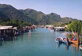
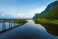
Harbor, Bang Pu | |
 Map of Thailand | |
| Location | Prachuap Khiri Khan Province, Thailand |
| Nearest city | Pranburi |
| Coordinates | 12°10′57″N 99°56′54″E / 12.18250°N 99.94833°ECoordinates: 12°10′57″N 99°56′54″E / 12.18250°N 99.94833°E |
| Area | 98,08 km2 |
| Established | 1966 |
Khao Sam Roi Yot (Thai: เขาสามร้อยยอด) is a marine national park in Sam Roi Yot District, Prachuap Khiri Khan Province, Thailand. It covers 98.08 km2, of which 20.88 km2 are marine areas. The park was established in 1966, and was the first coastal national park of Thailand.
Rare animals in the park include the mainland serow (Nemorhaedus sumatraensis), dusky langurs (Trachypithecus obscurus), as well as many bird species. At sea, the occasional Irrawaddy dolphin (Orcaella brevirostris) shows up.
Geography
Khao Sam Roi Yot means "mountain with 300 peaks.[1][2] The limestone hills are a sub-range of the Tenasserim Hills that arise at the shore of the Gulf of Thailand, with the highest elevation being Khao Krachom at 605 m. Between the hills are freshwater marshes. Several of these marshes were converted into shrimp farms, as only 36 km2 of the total 69 km2 of marshes are part of the national park. A portion, 18 km2, of these marshes are scheduled to be declared a Ramsar site.
Two white sand beaches are in the park, Hat Laem Sala and Hat Sam Phraya. Hat Laem Sala is 17 km from park headquarters and can be reached from the village Ban Pu either by boat or by climbing up and down over a hill for nearly 30 minutes.
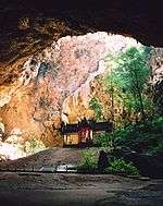
Phraya Nakhon Cave
Phraya Nakhon Cave is in Kui Buri District. It is managed by Khao Sam Roi Yot National Park. It is about 500 meters from Laem Sala beach and approximately 17 kilometers north of Khao Sam Roi Yot National Park. Tourists can go to the cave by renting a boat or by walking across Tian Mountain. After that, there is a climb up the mountain about 430 meters to reach Phraya Nakhon Cave.
There is a water well at the foot of the mountain known as Phraya Nakhon Well. It is made of baked clay bricks in a trapezoidal shape.
Phraya Nakhon is a large cave which has a hole in the ceiling allowing sunlight to penetrate. At the top of the hole, there is a stone bridge known as "death bridge" because many wild animals have fallen to their deaths from it. Many kings of Thailand have come to see this cave and left evidence of their visit.
The outstanding feature of Phraya Nakhon Cave is the "throne", a historic site built during King Rama V's (King Chulalongkorn) reign. The best time to see the throne is between 10:30 - 11:30 as the sun shines on the throne at that time. The throne has since become the symbol of Prachuap Khiri Khan Province.
Later kings also visited the cave. For the visit of King Chulalongkorn in 1890, the Kuha Karuhas pavilion was built inside the cave. Later, King Vajiravudh, as well as King Bhumibol Adulyadej visited the cave.
History
Khao Sam Roi Yot was probably where King Mongkut hosted European guests on 18 August 1868 to observe a total solar eclipse. The king was interested in astronomy and had calculated the date and location of the eclipse himself. His calculations proved better—by about two seconds—than those of French astronomers, who acknowledged his accuracy. He contracted malaria, possibly during that event, and died on 1 October.
The national park was created on 28 June 1966.[3] It was enlarged on 1 April 1982.[4]
Khao Sam Roi Yot legends
According to Thai folklore, the giant Mong Li and his wife lived on the west coast of the Gulf of Thailand. Each had independently promised their daughter to Chao Lai and the emperor of China. When the daughter was old enough to marry, both future husbands arrived on the same date. Mong Li then cut his daughter into two halves. Chao Lai turned himself into a hill, while the traditional fruit basket to be presented to a Buddhist monk was turned into the Khao Sam Roi Yot mountains.
Islands
The island of Ko Kho Ram on the other side of the gulf was the elephant and the ox cart with the wedding presents.[5] Nom Sao Island is the daughter's breasts. Ao Sam Roi Yot, Kho Ram Island and Nom Sao Island's silhouette, seen from certain angles, look like a person resting in the middle of the sea. There is a goddess shrine on Nom Sao Island that is a popular attraction.[6]
Other islands in the same area are Ko Sattakut, Ko Rawang, and Ko Rawing. [7]
Additional images
-
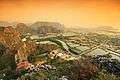
Khao Daeng viewpoint
-

The lotus pond
-
The lotus pond
See also
References
- ↑ "Khao Sam Roi Yot National Park". Department of National Parks (DNP) Thailand. Archived from the original on 15 October 2015. Retrieved 14 August 2015.
- ↑ "Khao Sam Roi Yot National Park". Tourism Authority of Thailand (TAT). Retrieved 6 November 2016.
- ↑ พระราชกฤษฎีกากำหนดบริเวณที่ดินป่าเขาสามร้อยยอด ในท้องที่ตำบลสามร้อยยอด ตำบลศิลาลอย อำเภอปราณบุรี และตำบลสามกระทาย ตำบลดอนยายหนู ตำบลเขาแดง อำเภอกุยบุรี จังหวัดประจวบคีรีขันธ์ ให้เป็นอุทยานแห่งชาติ พ.ศ. ๒๕๐๙ (PDF). Royal Gazette (in Thai). 83 (53 ก): 420–423. 28 June 1966.
- ↑ พระราชกฤษฎีกาขยายเขตอุทยานแห่งชาติป่าเขาสามร้อยยอด ในท้องที่ตำบลสามร้อยยอด ตำบลศิลาลอย ตำบลไร่เก่า อำเภอปราณบุรี และตำบลสามกระทาย ตำบลดอนยายหนู ตำบลเขาแดง อำเภอกุยบุรี จังหวัดประจวบคีรีขันธ์ พ.ศ. ๒๕๒๕ (PDF). Royal Gazette (in Thai). 99 (46 ก special): 5–8. 1 April 1982.
- ↑ Ko Kho Ram - Mapcarta
- ↑ Khao Sam Roi Yot National Park - Activities Archived March 17, 2010, at the Wayback Machine.
- ↑ Ko Rawing
Further reading
- Denis Gray, Collin Piprell, Mark Graham: National Parks of Thailand. Communications Resources Ltd., Bangkok 1991, ISBN 974-88670-9-9
External links
| Wikimedia Commons has media related to Khao Sam Roi Yot National Park. |
- ASEAN Regional Centre for Biodiversity Conservation
- Bangkok Post article in the land use controversies
- thaibirding.com on Khao Sam Roi Yot National Park
- Travel to Phraya Nakhon Cave (Thai)
- Phraya Nakhon Cave – Prachuaptown (Thai)
- The park King Chulalongkorn visited (Thai)