Phu Sang National Park
| Phu Sang National Park | |
|---|---|
| อุทยานแห่งชาติภูซาง | |
|
IUCN category II (national park) | |
|
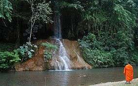
The water of Namtok Phu Sang comes from a hot spring with water temperatures around 33-35°C | |
 Location within Thailand | |
| Location | Chiang Rai and Phayao Provinces |
| Coordinates | 19°32′N 100°27′E / 19.53°N 100.45°ECoordinates: 19°32′N 100°27′E / 19.53°N 100.45°E[1] |
| Area | 284.88 |
| Established | 2000 |
| Governing body | สำนักอุทยานแห่งชาติ |
Phu Sang National Park (Thai: อุทยานแห่งชาติภูซาง) is a national park in Northern Thailand.
It covers the Thoeng District of Chiang Rai Province and Chiang Kham and Phu Sang Districts of Phayao Province.
Description
Phu Sang National Park is located in one of the north-easternmost mountain chains of the Phi Pan Nam Range bordering Laos.[2] The sources of many rivers are in these mountains. The park also has caves with stalactites and stalagmites and a warm water waterfall, Namtok Wang Kaew.[3]
Flora and fauna
Trees in the protected area include Dipterocarpus obtusifolius, Dipterocarpus alatus, Dipterocarpus turbinatus, Lagerstroemia loudonii, Lagerstroemia calyculata, Lagerstroemia tomentosa, Anisoptera costata, Michelia floribunda, Artocarpus lacucha, Pterocarpus macrocarpus, Afzelia xylocarpa, Xylia xylocarpa, Terminalia bellirica, Tectona grandis, Dillenia pentagyna, Schleichera oleosa, Lithocarpus densiflorus and Irvingia malayana.
Animals in the park area include the Indian muntjac, the Burmese hare, the Indochinese flying squirrel, black giant squirrel, the Java mouse-deer and the jungle cat.