Sai Thong National Park
| Sai Thong National Park | |
|---|---|
| อุทยานแห่งชาติไทรทอง | |
|
IUCN category II (national park) | |
|
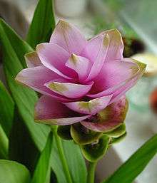
Krachiao blossoms | |
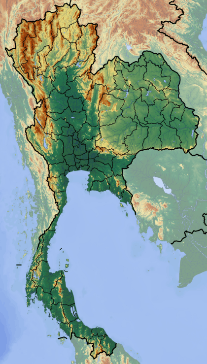 Park location in Thailand | |
| Location | Thailand |
| Nearest city | Chaiyaphum |
| Coordinates | 15°52′17″N 101°30′54″E / 15.87139°N 101.51500°ECoordinates: 15°52′17″N 101°30′54″E / 15.87139°N 101.51500°E |
| Area | 319 km2 (120 sq mi) |
| Established | 30 December 1992[1] |
| Governing body | Department of National Parks, Wildlife and Plant Conservation |
Sai Thong National Park (Thai: อุทยานแห่งชาติไทรทอง) is a national park in Thailand's Chaiyaphum Province. This mountainous park features waterfalls, scenic viewpoints and a seasonal flower field.[2]
Geography
Sai Thong National Park is located about 70 kilometres (40 mi) west of Chaiyaphum town in the Nong Bua Rawe, Thep Sathit, Phakdi Chumphon and Nong Bua Daeng districts of Chaiyaphum Province. The park's area is 319 square kilometres (120 sq mi). The park is located in the Phang Hoei mountain range and the park's highest point is Khao Phang Hoei at 1,008 metres (3,307 ft).[2] Numerous tributaries of the Chi River have their source within the park's boundaries.[1]
Attractions
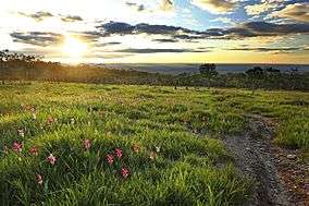
- Pha Hum Huet: A frequently photographed viewpoint in the park, providing cliff-edge views over the surrounding landscape. The Bua Sawan flower field covers the western ridge of Khao Phang Hoei peak and, from June to August each year, is home to Siam tulips in full bloom. A similar Siam tulip field is also found at nearby Pa Hin Ngam National Park.[2]
- Namtok Sai Thong (น้ำตกไทรทอง): The Sai Thong waterfall is 80 metres (260 ft) wide and 5 metres (16 ft) high, and is at peak flow during the rainy season. A large pool upstream feeds the falls and provides a swimming area. At the front of the waterfall is a large basin for swimmers called Wang Sai. Also, above the waterfall is a deep body of water called Wang Ngueak whose water runs along the crooked and steep stone plateau towards Namtok Sai Thong for a distance of 150 metres.
- Namtok Chuan Chom (น้ำตกชวนชม): Chuan Chom waterfall, 2 kilometres (1 mi) upstream of Sai Thong waterfall, is larger at 80 metres (260 ft) wide and 20 metres (70 ft) high.[2] This waterfall is along a nature study route of two kilometres above Namtok Sai Thong.
- Thung Bua Sawan or Thung Dok Krachiao (ทุ่งบัวสวรรค์ หรือทุ่งดอกกระเจียว): From the end of June to mid-August, curcuma or Krachiao blossoms will bloom in this field in both pink and white colours.
- Pha Pho Mueang (ผาพ่อเมือง) A cliff along the west side of the Phang Hoei mountain ridge along the route leading upward to the Bua Sawan Field, a distance of approximately three kilometres and 700–908 metres elevation.
- Pha Ham Hot View Spot (จุดชมทิวทัศน์ผาหำหด) The summit of the Phang Hoei mountain range, 864 metres elevation. It is cold throughout the year.
- Tham Kaeo (ถ้ำแก้ว): The cave is similar to a hall, located deep inside the mountain and chilly and humid throughout the year. From the entrance, there is a path leading to a lower level where a Buddha image is enshrined.
- Khao Phang Hoei Viewpoint (จุดชมทิวทัศน์เขาพังเหย): A rest area for motorists. Along the road lie various shops offering local products. The panoramic view of the sunset from this point is admirable.
Flora
The park's forest types consist of mixed deciduous, dipterocarp and dry evergreen forest.[1]
References
- 1 2 3 "Sai Thong National Park". Department of National Parks (Thailand). Retrieved 23 June 2014.
- 1 2 3 4 Sutthipibul, Vasa; Ampholchantana, Chantanaporn; Dulkull Kapelle, Peeranuch; Charoensiri, Vatid; Lukanawarakul, Ratana, eds. (2006). "Sai Thong National Park" (PDF). National Parks in Thailand. (free online from the publisher). Department of National Parks (Thailand). pp. 142–143. ISBN 974-286-087-4. Retrieved 23 June 2014.
External links
- Concise Sai Thong National Park information from the Tourism Authority of Thailand