Thung Salaeng Luang National Park
| Thung Salaeng Luang National Park | |
|---|---|
|
IUCN category II (national park) | |
 | |
 Location within Thailand | |
| Location | Phitsanulok and Phetchabun Provinces, Thailand |
| Coordinates | 16°49′40″N 100°52′12″E / 16.82778°N 100.87000°ECoordinates: 16°49′40″N 100°52′12″E / 16.82778°N 100.87000°E |
| Area | 1,262 km2 |
| Established | 1963 |
| Visitors | 105,930[1] (in 2007) |
Thung Salaeng Luang National Park (Thai: อุทยานแห่งชาติทุ่งแสลงหลวง) is a 1,262 km2 national park in Phitsanulok and Phetchabun Provinces of Thailand. It encompasses substantial portions of Amphoe Wang Thong and Amphoe Lom Sak.[2]
Topography
The park consists of limestone hills, slate and hardpan at altitudes ranging from 300 to 1,028 meters.[3] Thung Salaeng Luang is inlaid with meadows, especially in the southern portions of the park.[3] The park is the source of numerous streams. [3] There are large salt licks at Pong Sai in the northwest and Pong Thung Phaya in the southwest.[3] the Wang Thong River flows through the park.
Forest
The park's forest is primarily classified as deciduous, with lowland scrub and tropical broadleaved evergreen covering smaller areas.[3]
Climate
The average annual temperature is 25° C, although temperatures often reach 30° C during late spring and early summer.[3] The average annual rainfall is 1.7 meters.[3]
History
Thung Salaeng Luang was proposed for inclusion in the national parks system In 1959. Thung Salaeng Luang was declared a national park in 1972.[3] From the late 1960s to the early 1980s, the park's forest was used as a base for guerrillas of the Communist Party of Thailand.[3]
Thung Salaeng
Thung Salaeng is a meadow area of the park.
Thung Nang Phaya
Thung Nang Phaya is a meadow area of the park known for its combination of meadow and pine trees.[3]
Thung Non Son
Thung Non Son is a meadow area near the center of the park on a plateau. In the fall, Thung Non Son is resplendent with large clusters of flowers.[3]
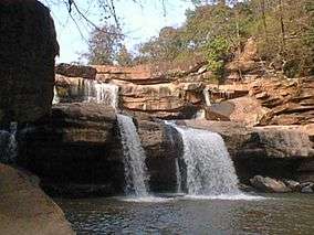
Kaeng Sopha Waterfall
Thung Salaeng Luang National Park is home to the Kaeng Song Waterfall, (or Namtok Kaeng Sopha) which is a three-tiered waterfall of the Wang Thong River.[3] Shaped like a stairway, Kaeng Sopha is the largest waterfall in Phitsanulok, and it has been dubbed the Niagara Falls of Thailand. The torrents are very strong in the rainy season. The vapor rising in the area creates a vast rain-like curtain. Kaeng Sopha is the subject of a June 2007 postage stamp in the Thailand Waterfall series.
Animal species
| Phitsanulok Wildlife |
|---|
| Endangered |
| Vulnerable |
| Near threatened |
| National Parks |
|
Kaeng Chet Khwae |
Among the species of animals in the park are:[3]
- Elephant
- Yellow-throated marten
- Masked palm civet
- Heron
- Eagle
- Partridge
- Pheasant
- Pigeon
- Owl
- Swift
- Hornbill
- Barbet
- Woodpecker
- Bulbul
- Babbler
- Warbler
- Flycatcher
- Flowerpecker
Plant species
Many of the wild meadow flowers bloom in November.[3]
Malaria
Historically, malaria was a health issue in the park.[3]
Caves
The park has several caves including Wang Daeng and Dao Duan.
Rapids
Kaeng Wang Nam Yen Rapids are located within the park.
Effects of human presence
Communist insurgents as well as hilltribe people and other intruders have destroyed some of the park's flora and fauna over the years.[3]
Facilities
There are seven bungalows at the park's headquarters and five bungalows at Nong Mae Na office.[3] There are also four campsites at the park.[3] There are no concessions in the park.
References
External links
| Wikimedia Commons has media related to Thung Salaeng Luang National Park. |