Doi Phu Kha National Park
| Doi Phu Kha National Park | |
|---|---|
| อุทยานแห่งชาติดอยภูคา | |
|
IUCN category II (national park) | |
 | |
 Location within Thailand | |
| Location | Thailand |
| Nearest city | Nan |
| Coordinates | 19°12′2″N 101°4′5″E / 19.20056°N 101.06806°ECoordinates: 19°12′2″N 101°4′5″E / 19.20056°N 101.06806°E |
| Area | 1704 km² |
| Established | June 17, 1999 |
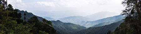
Doi Phu Kha National Park (Thai: อุทยานแห่งชาติดอยภูคา) covers a part of 8 districts in the Luang Prabang Range, Nan Province, Northern Thailand and has rich natural resources. It is Northern Thailand's largest National park and rivers such as Nan River and Pua River, have their sources within the area of the range under the protection of the park limits. Khun Nan National Park is located north of the park area.
1,980 m high Doi Phu Kha, located within the parks perimeter, gives its name to the park. There are many caves in the park area. The park is named after Chompoo Phu Kha (Thai: ชมพูภูคา Bretschneidera sinensis), a tree with attractive pink flower bunches, which together with Caryota gigas and Acer wilsonii, are rare species of plant which in Thailand can be found only in this park. There are natural rock formations on 1,837 m high Doi Phu Wae peak. The ascent takes 3 days and 2 nights. The scenery of the sea of mist and the mountain range is the reward for the trekkers who can reach Phu Wae peak.[1]
The park was established on June 17, 1999.[2] In 2009 the 246 km² central area of the park was regazetted.[3] Doi Phu Kha National Park is part of the Luang Prabang montane rain forests ecoregion.[4]
King Bhumibol Adulyadej has blamed the destruction of Thailand's forested areas on the greed of some state officials. This is evident in large zones of Doi Phu Kha National Park that were formerly covered with virgin forest and that have been deforested even while having national park status.[5]
See also
References
- ↑ Doi Phu Kha National Park
- ↑ พระราชกฤษฎีกากำหนดบริเวณที่ดินป่าดอยภูคา ป่าผาแดง ป่าแม่น้ำน่านฝั่งตะวันออกตอนใต้ ป่าน้ำว้า และป่าแม่จริม ในท้องที่ตำบลห้วยโก๋น ตำบลขุนน่าน อำเภอเฉลิมพระเกียรติ ตำบลปอน ตำบลงอบ ตำบลและ ตำบลทุ่งช้าง อำเภอทุ่งช้าง ตำบลพญาแก้ว อำเภอเชียงกลาง ตำบลภูคา ตำบลศิลาเพชร ตำบลอวน อำเภอปัว ตำบลบ่อเกลือเหนือ ตำบลดงพญา ตำบลบ่อเกลือใต้ ตำบลภูฟ้า อำเภอบ่อเกลือ ตำบลยม อำเภอท่าวังผา ตำบลพงษ์ อำเภอสันติสุข และตำบลแม่จริม ตำบลหนองแดง ตำบลน้ำพาง อำเภอแม่จริม จังหวัดน่าน ให้เป็นอุทยานแห่งชาติ พ.ศ. ๒๕๔๒ (PDF). Royal Gazette (in Thai). 116 (48 ก): 5. 1999-06-17.
- ↑ พระราชกฤษฎีกากำหนดบริเวณที่ดินป่าดอยภูคา และป่าผาแดง ในท้องที่ตำบลดงพญา ตำบลบ่อเกลือใต้ และตำบลภูฟ้า อำเภอบ่อเกลือ จังหวัดน่าน ให้เป็นอุทยานแห่งชาติ พ.ศ. ๒๕๕๒ (PDF). Royal Gazette (in Thai). 126 (43 ก): 100–102. 2009-07-15.
- ↑ Luang Prabang montane rain forests - Globalspecies
- ↑ King says greed a factor in floods - Govt urged to find ways to prevent deforestation
External links
| Wikimedia Commons has media related to Doi Phu Kha. |
- "Luang Prabang montane rain forests". Terrestrial Ecoregions. World Wildlife Fund.
- National Park Division
- Birdwatching Doi Phu Kha National Park