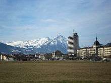
Interlaken
| Interlaken | ||
|---|---|---|
|
Interlaken | ||
| ||
 Interlaken | ||
|
Location of Interlaken  | ||
| Coordinates: 46°41′N 7°51′E / 46.683°N 7.850°ECoordinates: 46°41′N 7°51′E / 46.683°N 7.850°E | ||
| Country | Switzerland | |
| Canton | Bern | |
| District | Interlaken-Oberhasli | |
| Government | ||
| • Executive |
Gemeinderat with 7 members | |
| • Mayor |
Gemeindepräsident Urs Graf SPS/PSS (as of March 2014) | |
| • Parliament |
Grosser Gemeinderat with 30 members | |
| Area[1] | ||
| • Total | 4.3 km2 (1.7 sq mi) | |
| Elevation (Convent/Castle) | 566 m (1,857 ft) | |
| Population (Dec 2015[2]) | ||
| • Total | 5,692 | |
| • Density | 1,300/km2 (3,400/sq mi) | |
| Demonym(s) | German: Interlakener(in) | |
| Postal code | 3800 | |
| SFOS number | 0581 | |
| Localities | Im Moos, Öli | |
| Surrounded by | Bönigen, Därligen, Matten bei Interlaken, Ringgenberg, Unterseen | |
| Twin towns | Scottsdale (USA), Ōtsu (Japan), Třeboň (Czech Republic) | |
| Website |
www SFSO statistics | |


Interlaken (German pronunciation: [ˈɪntɐlakn̩]; lit.: between lakes) is a statistic town and municipality in the Interlaken-Oberhasli administrative district in the Swiss canton of Bern. It is an important and well-known tourist destination in the Bernese Highlands region of the Swiss Alps, and the main transport gateway to the mountains and lakes of that region.
The town is located on the flat alluvial land called Bödeli between the two Lakes of Brienz to the east and Thun to the west and alongside the river Aare, which flows from one to the other. Transport routes to the east and west alongside the lakes are complemented by a route southwards into the near mountain resorts and high mountains, e.g. the famous high Alpine peaks of Eiger, Mönch, and Jungfrau, following upwards the Lütschine.
Interlaken is the central town of a Small Agglomeration with the same name of 23,300 inhabitants.[3]
The official language of Interlaken is (the Swiss variety of Standard) German, but the main spoken language is the local variant of the Alemannic Swiss German dialect.
History

Until 1891, Interlaken was known as Aarmühle.[4] The convent of the Augustinian Canons was built around 1133 when it was mentioned as inter lacus Madon and lasted until 1528.[5] The mill on the left bank of the Aare was first mentioned in 1365 as Amuli, while the town on the right bank was mentioned in 1239 as villa Inderlappen.[4]
Previously, printing, textiles, and to a smaller extent watchmaking were also of importance, but today tourism is the most significant source of income. Interlaken is one of the oldest tourist resorts in Switzerland, and it remains one of the most popular.
Early history
While some scattered Neolithic flint objects, early Bronze Age swords and Roman era coins have been found near Interlaken, there is no evidence for a settlement in the area before the Middle Ages. Interlaken Monastery was built around 1133 on imperial land on the left side of the Aare. The monastery controlled a bridge over the river and generated an income from tolls. A village grew up around the monastery, along with a mill (which gave the municipality its name until 1891). On the right bank of the river, Interlaken village developed. In 1279/80 the village of Unterseen developed near Interlaken village. Also near the village were the imperial castle of Weissenau and the market town of Widen. The castle and market town became the possessions of the monastery, but fell into disrepair in the Late Middle Ages.[4]
Interlaken Monastery
_050.JPG)
The Interlaken Monastery was first mentioned in 1133 when Lothair III, Holy Roman Emperor took it under his protection. By 1247, there were also women at the monastery. During the 13th century the monastery's influence spread throughout the neighboring area and into the Aare and Gürbe valleys. They eventually had authority over two dozen churches along with a number of villages and farms and became the largest religious landholder in the region.[6]
During the 13th and the beginning of the 14th century the monastery grew and prospered. However, in 1350 a period of crises and conflicts led to a decline in the number of monks and nuns and increasing debt. A document from 1310, indicates that there were 30 priests, 20 lay brothers and 350 women at the monastery. In contrast, in 1472 there were only the provost, the prior, nine ordinary canons, seven novices and 27 nuns. At this time, the monastery also had problems with its tenants and neighbors. In 1348, the people of Grindelwald and Wilderswil joined a mutual defense league with Unterwalden. Bern responded with a military expedition to the Bernese Oberland, which ended in defeat for Unterwalden and its allies.[5] In 1445 the Evil League (Böser Bund) rose up in the Oberland near Interlaken and fought against Bernese military service and taxes following the Old Zürich War.[6]
During the 14th century the canons and nuns stopped following most of the monastic rules. In 1472 a violent dispute between the men and the women's convents resulted in two visitation by the Bishop of Lausanne who noted serious deficiencies. The provost was arrested and some of the canons were replaced by canons from other convents. Despite the reform measures the nun's convent was closed in 1484 and its property transferred to the newly founded monastery of St. Vincent in Berne.[5]
During the Protestant Reformation, the monastery was secularized in 1528. The canons received a financial settlement and the properties were now managed by a Bernese bailiff. The tenants of the monastery who had expected the abolition of all owed interest, responded by rioting, which was suppressed by Berne.[5]
After the Reformation, Berne created the Interlaken bailiwick from the monastery lands. Part of the monastery building was used as the headquarters of the district administration, while the rest was used as an indigent hospital. In 1562-63 Berne converted the monastery church's choir into a granary and a wine cellar. In 1746-50 the west wing was demolished and Governor Samuel Tillier built the so-called New Castle. It has remained the center of administration for the Interlaken district since that time.[5]
Aarmühle village

Aarmühle was named for the mill on the Aare which was built there in or before 1365. Starting in 1365, the monastery held weekly and yearly markets at Aarmühle. It had its own bäuert (agricultural cooperative) but was politically part of the municipality of Matten.[7]
In the 16th century the bäuert of Aarmühle and the surrounding bäuerten began quarreling over the use of common fields and woods. Attempts at arbitration in 1533, 1586 and 1618 were unsuccessful. Partly as a result of the quarreling, in 1633, Wilderswil separated from Matten and became an independent municipality. However, the dispute continued between Aarmühle and Matten and in 1761, the governor of the Interlaken district attempted, unsuccessfully, to mediate. Finally, in 1810 the two villages divided their common property, though it took until 1838 for Aarmühle to become an independent political municipality.[7]
Around the time of the separation, the number of tenant farmers (farmers that did not own the land that they worked) was very different in Aarmühle and Matten. In 1831, 37% of the population in Aarmühle were tenants, while only 12% were in Matten. This meant that the population of Matten were closely tied to the land and remained farmers, while in Aarmühle they began to support the growing tourism trade.[7]
Aarmühle becomes Interlaken
On the right bank of the Aare, Unterseen became the only municipality and absorbed the village of Interlaken. In 1838, on the left bank, the villages became the two municipalities of Matten and Aarmühle. However, Aarmühle used the name Interlaken for its post office and train station, leading to that name becoming more well known. Officially the name changed to Interlaken in 1891.[4]
Rise of tourism
_-_n._13176_INTERLAKEN_%26_Jungfrau.jpg)

Interlaken's reputation as international resort started around 1800 due to the landscapes of Franz Niklaus König and other Swiss landscape artists. The success of the Unspunnenfest, a festival of Swiss culture, in 1805 and 1808 brought many tourists to Interlaken. Starting in 1820, they came for mountain air and spa treatment and the large Kursaal opened in 1859 to provide an elegant spa. The many hotels combined with good transportation links made it easy for these early tourists to visit. In 1835 a steam ship route opened along Lake Thun from Thun, followed in 1839 by another along Lake Brienz from Brienz.[4]
In 1872, the Bödelibahn railway opened from Därligen, on Lake Thun, to Interlaken. Two years later it was extended to Bönigen, on Lake Brienz. Initially this line was unconnected to the rest of the Swiss railway system, and served as a link between the steamships on both lakes. However, in 1893, the Thunersee railway opened alongside Lake Thun providing a direct rail connection to Thun, with onward connections to Bern and beyond. In 1888, the Brünig railway opened between Alpnachstad, on Lake Lucerne, and Brienz, on Lake Brienz, thus providing a through steamer and rail connection from Interlaken to Lucerne. By 1916, the Brünig railway had reached Interlaken from Brienz, and, together with an earlier extension at its eastern end, provided a direct rail route to Lucerne. In 1890, the Berner Oberland railway connected Interlaken to the tourist destinations of Lauterbrunnen and Grindelwald.[4][8]
With the opening up of transport links, hotels developed along the route to the Jungfrau. In 1860-75 and 1890-1914 several luxury hotels were built with views of the Jungfrau and surrounding mountains. The current Kursaal was built in 1898-99 and remodeled in 1909-10.[4]
Despite the emphasis on tourism a parquet factory operated from 1850 until 1935 and a wool weaving factory opened in 1921. In the late 20th century a woolen thread and a metal products factory opened in Interlaken. Since 1988, Interlaken has been connected to the A8 motorway.[4]
Modern Interlaken
The frantic growth of the tourism industry abruptly ended in 1914 when World War I started, though it resumed somewhat after the war. World War II brought another dramatic slow down. Interlaken started to recover from the effects of the war in 1955 as Interlaken re-branded itself as a convention and conference center. Today, the two nuclei villages (Aarmühle and the village around the Bailiff's Castle) have been joined by new construction between them. The municipalities of Matten and Unterseen are also connected by new construction to Interlaken and share a common infrastructure. A referendum to merge the three political municipalities into one was voted down in 1914 and again in 1927.[4]
Geography
Topography

Interlaken is located at 566 m (1,857 ft) above sea level, between Lake Brienz to the east and Lake Thun to the west on the alluvial land called Bödeli. The town takes its name from its geographical position between the lakes (in Latin inter lacus). The Aare flows through the town from one to the other lake, whilst the Lütschine flows from the mountains from the south into Lake Brienz however not running through the municipality of Interlaken.
The municipality of Interlaken has an area of 4.3 km2 (1.66 sq mi).[1] Of this area, 1.05 km2 (0.41 sq mi) or 24.4% is used for agricultural purposes, while 0.97 km2 (0.37 sq mi) or 22.6% is forested. Of the rest of the land, 2.03 km2 (0.78 sq mi) or 47.2% is settled (buildings or roads), 0.3 km2 (0.12 sq mi) or 7.0% is either rivers or lakes and 0.01 km2 (2.5 acres) or 0.2% is unproductive land.[9]
Of the built up area, industrial buildings made up 5.3% of the total area while housing and buildings made up 21.4% and transportation infrastructure made up 16.0%. while parks, green belts and sports fields made up 4.0%. Out of the forested land, 20.9% of the total land area is heavily forested and 1.6% is covered with orchards or small clusters of trees. Of the agricultural land, 6.5% is used for growing crops and 16.3% is pastures, while 1.6% is used for orchards or vine crops. All the water in the municipality is flowing water.[9]
Climate
Climate in this area has mild differences between highs and lows, and there is adequate rainfall year round. The Köppen Climate Classification subtype for this climate is "Cfb" (Marine West Coast Climate/Oceanic climate).[10]
| Climate data for Interlaken (Reference period 1981-2010) | |||||||||||||
|---|---|---|---|---|---|---|---|---|---|---|---|---|---|
| Month | Jan | Feb | Mar | Apr | May | Jun | Jul | Aug | Sep | Oct | Nov | Dec | Year |
| Average high °C (°F) | 3.1 (37.6) |
5.1 (41.2) |
10.1 (50.2) |
14.1 (57.4) |
18.8 (65.8) |
21.9 (71.4) |
24.4 (75.9) |
23.5 (74.3) |
19.3 (66.7) |
14.4 (57.9) |
7.7 (45.9) |
3.8 (38.8) |
13.9 (57) |
| Daily mean °C (°F) | −0.3 (31.5) |
0.9 (33.6) |
4.9 (40.8) |
8.7 (47.7) |
13.2 (55.8) |
16.3 (61.3) |
18.4 (65.1) |
17.7 (63.9) |
14.0 (57.2) |
9.6 (49.3) |
4.0 (39.2) |
0.9 (33.6) |
9.0 (48.2) |
| Average low °C (°F) | −3.6 (25.5) |
−3.0 (26.6) |
0.3 (32.5) |
3.4 (38.1) |
7.9 (46.2) |
11.1 (52) |
13.2 (55.8) |
12.8 (55) |
9.5 (49.1) |
5.6 (42.1) |
0.6 (33.1) |
−2.2 (28) |
4.6 (40.3) |
| Average precipitation mm (inches) | 73 (2.87) |
70 (2.76) |
80 (3.15) |
87 (3.43) |
121 (4.76) |
138 (5.43) |
139 (5.47) |
144 (5.67) |
96 (3.78) |
78 (3.07) |
84 (3.31) |
86 (3.39) |
1,196 (47.09) |
| Average snowfall cm (inches) | 28.1 (11.06) |
26.5 (10.43) |
11.4 (4.49) |
0.8 (0.31) |
0 (0) |
0 (0) |
0 (0) |
0 (0) |
0 (0) |
0 (0) |
5.6 (2.2) |
17.8 (7.01) |
90.2 (35.51) |
| Average precipitation days (≥ 1.0 mm) | 9.6 | 8.7 | 11.0 | 10.6 | 12.7 | 13.4 | 12.4 | 12.6 | 9.5 | 9.3 | 9.7 | 9.6 | 129.1 |
| Average snowy days (≥ 1.0 cm) | 4.6 | 4.7 | 3.1 | 0.4 | 0 | 0 | 0 | 0 | 0 | 0 | 1.1 | 3.2 | 17.1 |
| Average relative humidity (%) | 82 | 78 | 73 | 70 | 72 | 73 | 73 | 76 | 80 | 82 | 83 | 83 | 77 |
| Mean monthly sunshine hours | 67 | 79 | 121 | 151 | 176 | 188 | 219 | 193 | 150 | 104 | 68 | 53 | 1,570 |
| Percent possible sunshine | 42 | 47 | 46 | 44 | 43 | 44 | 51 | 52 | 52 | 51 | 42 | 53 | 46 |
| Source: MeteoSwiss [11] | |||||||||||||
Politics
Coat of arms
The blazon of the municipal coat of arms is Argent a Semi Ibex rampant couped Sable langued Gules.[12]
Government
The Municipal Council (Gemeinderat) constitutes the executive government of the municipality of interlaken and operates as a collegiate authority. It is composed of seven councillors (German: Gemeinderat/-rätin), each responsible for a portfolio (Ressort). The councillor of the executive portfolio acts as an executive president (Gemeindepräsident). In the mandate period (Legislatur) 2012 – 2016 the Municipal Council is presided by Gemeindepräsident Urs Graf. Departmental tasks, coordination measures and implementation of laws decreed by the Grand Municipal Council are carried by the Municipal Council. The regular election of the Municipal Council by any inhabitant valid to vote is held every four years, starting 2016. Any Swiss resident of Interlaken allowed to vote can be elected as a member of the Municipal Council. The delegates are selected by means of a system of Proporz. The president is elected as such as well by public election by means of a system of Mayorz while the heads of the other portfolios are assigned by the collegiate.[13][14]
As of January 2012, Interlaken's Municipal Council is made up of three members of the SP (Social Democratic Party) of whom one is also the mayor, and two members each of the FDP (The Liberals) and SVP (Swiss People's Party). The last regular election (Landsgemeinde) was held on 25 September 2016. The voter turnout was 44%. All members and the mayor have been re-elected for the mandate period of 2017–2020.[15]
| Municipal Councillor (Gemeinderat/-rätin) | Party | Portfolio (Ressort, since) | elected since |
|---|---|---|---|
| Urs Graf[GR 1] | SP | Excecutive portfolio (Präsidiales, 2006) | 2005 |
| Kaspar Boss | SP | Building and Planning (Bau und Planung, 2012) | 2011 |
| Hans-Rudolf Burkhard[GR 2] | FDP | Guardianship/Social Services (Vormundschaft/Soziales, April 2010) | substitute 2010 (election 2007) |
| Franz Christ | SVP | Education (Bildung, May 2016) | substitute 2016 (election 2011) |
| Peter Michel | SVP | Security (Sicherheit, 2012) | 2011 |
| Phillipe Ritschard | FDP | Finances and Taxes (Finanzen und Steuern, 2012) | 2007 |
| Sabina Stör | SP | Civil Engineering (Industrielle Betriebe, 2010) | 2009 |
Parliament

The Grosse Gemeinderat of Interlaken for the mandate period of 2017-2020
The Grand Municipal Council (Grosser Gemeinderat, GGR) holds legislative power. It is made up of 30 members, with elections held every four years. The Grand Municipal Council decrees regulations and by-laws that are executed by the Municipal Council and the administration. The delegates are selected by means of a system of Proporz.
The sessions of the Grand Municipal Council are public. Any resident of Interlaken allowed to vote can be elected as a member of the Grand Municipal Council. The parliament holds its meetings six to eight times per year in the Kunsthaus (art musuem) at Amman-Hofer-Platz.[15]
The last regular election of the Grand Municipal Council was held on 25 September 2016 for the mandate period (German: Legislatur) from 2017 to 2020. Currently the Grand Municipal Council consist of 8 members of the The Liberals (FDP/PLR), 8 Swiss People's Party (SVP/UDC), 7 Social Democratic Party (SP/PS), 3 Green Party (GPS/PES), 3 Evangelical People's Party (EVP/PEV), and one member of the Federal Democratic Union (EDU/UDF).[15]
National elections
National Council
In the 2015 federal election for the Swiss National Council the most popular party was the UDC which received 30.4% of the vote. The next five most popular parties were the SP (18.6%), the BDP (14.3%), the FDP (11.4%), the Green Party (7.9%), and EVP (6.1%). In the federal election, a total of voters were cast, and the voter turnout was %.[17]
Demographics
Population

Interlaken has a population (as of December 2015) of 5,692.[18] As of 2010, 26.4% of the population are resident foreign nationals. Over the last 10 years (2000–2010) the population has changed at a rate of 5.3%. Migration accounted for 8.2%, while births and deaths accounted for -1.9%.[19]
Most of the population (as of 2000) speaks German (4,271 or 83.4%) as their first language, Portuguese is the second most common (198 or 3.9%) and Italian is the third (145 or 2.8%). There are 64 people who speak French and 11 people who speak Romansh.[20]
As of 2008, the population was 47.5% male and 52.5% female. The population was made up of 1,830 Swiss men (33.7% of the population) and 751 (13.8%) non-Swiss men. There were 2,164 Swiss women (39.9%) and 684 (12.6%) non-Swiss women.[21] Of the population in the municipality, 988 or about 19.3% were born in Interlaken and lived there in 2000. There were 1,923 or 37.6% who were born in the same canton, while 805 or 15.7% were born somewhere else in Switzerland, and 1,185 or 23.1% were born outside of Switzerland.[20]
As of 2000, children and teenagers (0–19 years old) make up 19.3% of the population, while adults (20–64 years old) make up 63.1% and seniors (over 64 years old) make up 17.6%. In the same year, there were 2,158 people who were single and never married in the municipality. There were 2,288 married individuals, 367 widows or widowers and 306 individuals who are divorced.[19][20]
As of 2000, there were 2,418 private households in the municipality, and an average of 2.0 persons per household. There were 1,041 households that consist of only one person and 74 households with five or more people. A total of 2,292 apartments (83.5% of the total) were permanently occupied, while 329 apartments (12.0%) were seasonally occupied and 125 apartments (4.6%) were empty. By 2009, the construction rate of new housing units was 4.6 new units per 1000 residents.[19][22]
As of 2003 the average price to rent an average apartment in Interlaken was 1013.98 Swiss francs (CHF) per month (US$810, £460, €650 approx. exchange rate from 2003). The average rate for a one-room apartment was 642.58 CHF (US$510, £290, €410), a two-room apartment was about 741.20 CHF (US$590, £330, €470), a three-room apartment was about 945.28 CHF (US$760, £430, €600) and a six or more room apartment cost an average of 1648.96 CHF (US$1320, £740, €1060). The average apartment price in Interlaken was 90.9% of the national average of 1116 CHF.[23] The vacancy rate for the municipality, in 2010, was 0.1%.[19]
The historical population is given in the following chart:[4][24]

Economy
As of 2010, Interlaken had an unemployment rate of 4.6%. As of 2008, there were 6 people employed in the primary economic sector and about 2 businesses involved in this sector. 807 people were employed in the secondary sector and there were 81 businesses in this sector. 5,185 people were employed in the tertiary sector, with 542 businesses in this sector.[19]
In 2008 the total number of full-time equivalent jobs was 4,903. The number of jobs in the primary sector was 4, all of which were in agriculture. The number of jobs in the secondary sector was 745 of which 281 or (37.7%) were in manufacturing and 397 (53.3%) were in construction. The number of jobs in the tertiary sector was 4,154. In the tertiary sector; 1,145 or 27.6% were in wholesale or retail sales or the repair of motor vehicles, 276 or 6.6% were in the movement and storage of goods, 1,170 or 28.2% were in a hotel or restaurant, 57 or 1.4% were in the information industry, 168 or 4.0% were the insurance or financial industry, 308 or 7.4% were technical professionals or scientists, 119 or 2.9% were in education and 360 or 8.7% were in health care.[25]
In 2000, there were 4,253 workers who commuted into the municipality and 1,117 workers who commuted away. The municipality is a net importer of workers, with about 3.8 workers entering the municipality for every one leaving.[26] Of the working population, 12.5% used public transportation to get to work, and 28.5% used a private car.[19]
Religion
_055.JPG)
From the 2000 census, 1,139 or 22.3% were Roman Catholic, while 2,873 or 56.1% belonged to the Swiss Reformed Church. Of the rest of the population, there were 83 members of an Orthodox church (or about 1.62% of the population), there were 4 individuals (or about 0.08% of the population) who belonged to the Christian Catholic Church, and there were 374 individuals (or about 7.31% of the population) who belonged to another Christian church.[20]
There were 3 individuals (or about 0.06% of the population) who were Jewish, and 170 (or about 3.32% of the population) who were Islamic. There were 29 individuals who were Buddhist, 43 individuals who were Hindu and 9 individuals who belonged to another church. 342 (or about 6.68% of the population) belonged to no church, are agnostic or atheist, and 235 individuals (or about 4.59% of the population) did not answer the question.[20]
Education
_021.JPG)
In Interlaken about 2,181 or (42.6%) of the population have completed non-mandatory upper secondary education, and 562 or (11.0%) have completed additional higher education (either university or a Fachhochschule). Of the 562 who completed tertiary schooling, 62.3% were Swiss men, 21.4% were Swiss women, 8.4% were non-Swiss men and 8.0% were non-Swiss women.[20]
Economy
Tourism


The town is principally a base from which to explore the surrounding areas. Among the main attractions are the mountains of the Jungfrau region, including the Jungfrau, (4,158 m (13,642 ft)), the Mönch (4,107 m (13,474 ft)) and the Eiger (3,970 m (13,020 ft)). Whilst the peaks of these mountains are accessible only to mountaineers, a sequence of connecting mountain railways gives access to the Jungfraujoch, a saddle (3,454 m (11,332 ft)) between the Jungfrau and the Mönch, but correctly tanslated as a yoke (German: Joch), which is the highest point in Europe reachable by train.
Closer to Interlaken, the Harderkulm (1,321 m (4,334 ft)), just to the north of the town, and the Schynige Platte (1,967 m (6,453 ft)), just to the south, are also accessible by railway, and provide extensive views of the higher mountains. Lake Thun and Lake Brienz are both close to the town, and the Aare flows east to west through the town. Boat trips operate on both lakes, serving various lakeside towns. One of these, Brienz, is the starting point for one of Switzerland's last remaining steam operated mountain railway, the Brienz-Rothorn railway.
Jungfrau Park, an amusement park, is situated just to the south of Interlaken. It was originally opened as a Mystery Park, a paranormal-based theme park owned by author Erich von Däniken, but was closed in 2006 after three years because of financial difficulties. It re-opened in its current guise in 2009.
Interlaken has a large selection of hotels of various grades, many of which are located along the Höheweg, a street that links the towns two railway stations and offers views of the mountains. Other hotels are clustered around one or other of the two stations, or located across the river in the neighbouring municipality of Unterseen.
Interlaken is also a destination for backpackers. It has numerous backpacker-friendly hotels and companies providing guided services in skydiving, canyoning, hang gliding, paragliding, and skiing.
Education
The canton of Bern school system provides one year of non-obligatory Kindergarten, followed by six years of Primary school. This is followed by three years of obligatory lower Secondary school where the students are separated according to ability and aptitude. Following the lower Secondary students may attend additional schooling or they may enter an apprenticeship.[27]
During the 2009-10 school year, there were a total of 667 students attending classes in Interlaken. There were 4 kindergarten classes with a total of 72 students in the municipality. Of the kindergarten students, 36.1% were permanent or temporary residents of Switzerland (not citizens) and 47.2% have a different mother language than the classroom language. The municipality had 15 primary classes and 275 students. Of the primary students, 33.8% were permanent or temporary residents of Switzerland (not citizens) and 43.1% have a different mother language than the classroom language. During the same year, there were 16 lower secondary classes with a total of 301 students. There were 17.6% who were permanent or temporary residents of Switzerland (not citizens) and 18.3% have a different mother language than the classroom language.[28] As of 2000, there were 450 students in Interlaken who came from another municipality, while 78 residents attended schools outside the municipality.[26]
Interlaken is home to the Bödeli-Bibliothek library. The library has (as of 2008) 22,043 books or other media, and loaned out 114,730 items in the same year. It was open a total of 292 days with average of 21 hours per week during that year.[29]
Transportation


Interlaken has two railway stations, Interlaken Ost and Interlaken West, which are both served by the BLS AG's Thunersee line that provides direct services to Spiez, Thun, Bern and beyond, with onward connections at Bern to the rest of Switzerland. Through international services are provided by TGV to Paris and ICE to Frankfurt and Berlin.[30]
Besides being the terminal of the Thunersee line, Interlaken Ost is also the terminus of the Zentralbahn's Brünig line to Brienz, Meiringen and Luzern, with onward connections to north-eastern Switzerland. The Berner Oberland railway also operates from Ost station, providing the first stage of several mountain railway routes into the Jungfrau region and, most notably, to Europe's highest station at the Jungfraujoch.
Boat services across Lake Brienz to Brienz and across Lake Thun to Spiez and Thun are operated by the BLS AG. The boats on Lake Thun operate from a quay adjacent to the West station, connected to Lake Thun by the Interlaken ship canal. The boats on Lake Brienz operate from a quay on the Aare by the Ost station. The remainder of the Aare between the two lakes is controlled by several weirs and is not navigable.
Interlaken is connected by the A8 motorway to Thun and Lucerne, with onward connections by other Swiss motorways to the rest of Switzerland. Local roads also follow both banks of the lakes to east and west, and follow the valley of the Lütschine south into the Jungfrau region. However it should be noted that there is no direct road connection across the mountains of that region into the canton of Valais to the south, with the nearest such connections being the Grimsel Pass to the east, or using the vehicle transport service through the Lötschberg rail tunnel to the west.
In the more immediate area, two funicular railways, the Harderbahn and the Heimwehfluhbahn, provide service to nearby vantage points. Local and regional bus services are provided by PostBus Switzerland, whilst Verkehrsbetriebe STI operates a regional bus service to Thun.
Culture
Events

- In September, the Jungfrau Marathon starts in Interlaken.
- The Unspunnenfest is a festival held in Interlaken and the neighbouring communities of Matten and Wilderswil approximately every twelve years. The festival highlights traditional Swiss culture and features competitions of Steinstossen (stone put), Schwingen (wrestling) and yodelling. The last Unspunnenfest was held in September 2006. The next celebration is scheduled for the year 2017.
- On 15 July 2007, the Red Bull Air Race World Series was held on the airport situated near Interlaken.
- During Summer, there is the Greenfield Music Festival on the outskirts of Interlaken.
Heritage sites of national significance

The former Monastery Building, the Hotel Royal-St. Georges, the Hotel Victoria-Jungfrau and the Kursaal are listed as Swiss heritage site of national significance. The entire urbanized village of Interlaken is part of the Inventory of Swiss Heritage Sites.[31]
Notable people
- Hanery Amman (*1952), rock mucisian
- Adrian Frutiger (1928–2015), typographer
- Rudolf Häsler (1927–1999), painter
- Polo Hofer (*1945), rock mucisian
- Markus Imboden (*1955), film director and scriptwriter
- Kilian Moser (*1988), rycing cyclist
- Dölf Reist (1921–2000), fotographer and alpinist
- Hans Schaffner (1908–2004), politician and former Federal Councillor
References
- 1 2 Arealstatistik Standard - Gemeindedaten nach 4 Hauptbereichen
- ↑ Swiss Federal Statistical Office - STAT-TAB, online database – Ständige und nichtständige Wohnbevölkerung nach institutionellen Gliederungen, Geburtsort und Staatsangehörigkeit (German) accessed 30 August 2016
- ↑ "Städtische Bevölkerung: Agglomerationen und isolierte Städte" (XLS) (in German and French). Neuchâtel, Switzerland: Swiss Federal Statistical Office. 2014. Retrieved 2016-09-26.
- 1 2 3 4 5 6 7 8 9 10 Anne-Marie Dubler: Interlaken (municipality) in German, French and Italian in the online Historical Dictionary of Switzerland, 2007-11-01.
- 1 2 3 4 5 Barbara Studer: Interlaken (Monastery, District) in German, French and Italian in the online Historical Dictionary of Switzerland, 2008-01-23.
- 1 2 Böser Bund in Berner Oberland in German, French and Italian in the online Historical Dictionary of Switzerland.
- 1 2 3 Aarmühle in German, French and Italian in the online Historical Dictionary of Switzerland.
- ↑ Jürg Ehrbar. "Interlaken Ost–Bönigen". eingestellte-bahnen.ch (Amateur site) (in German). Zweisimmen, Switzerland: Jürg Ehrbar. Retrieved 2012-09-26.
- 1 2 Swiss Federal Statistical Office-Land Use Statistics 2009 data (German) accessed 25 March 2010
- ↑ "Interlaken, Switzerland". Great Falls, VI, USA: CantyMedia, Canty and Associates LLC. n.d.
- ↑ "Climate normals Interlaken, Reference period 1981−2010" (PDF). Zürich-Airport, Switzerland: Swiss Federal Office of Meteorology and Climatology - MeteoSwiss. 2 July 2014. Retrieved 2016-10-04.
- ↑ Flags of the World.com accessed 8 February 2012
- ↑ "Organe/Behörden: Stimmberechtigte" (official site) (in German). Interlaken, Switzerland: Gemeinde Interlaken. 2016. Retrieved 2016-10-06.
- ↑ "Organe/Behörden: Gemeinderat" (official site) (in German). Interlaken, Switzerland: Gemeinde Interlaken. 2016. Retrieved 2016-10-06.
- 1 2 3 "Aktualitäten: Gesamterneuerungswahlen 2017 bis 2020" (official site) (in German). Interlaken, Switzerland: Gemeinde Interlaken. 26 September 2016. Retrieved 2016-10-06.
- ↑ "Organe/Behörden: Gemeinderatsmitglieder" (official site) (in German). Interlaken, Switzerland: Gemeinde Interlaken. 2016. Retrieved 2016-10-06.
- ↑ "Nationalratswahlen 2015: Stärke der Parteien und Wahlbeteiligung nach Gemeinden" (XLS) (official statistics) (in German and French). Neuchâtel, Switzerland: Swiss Federal Statistical Office. 4 March 2016. Retrieved 2016-08-03.
- ↑ Swiss Federal Statistical Office - STAT-TAB, online database – Ständige und nichtständige Wohnbevölkerung nach institutionellen Gliederungen, Geburtsort und Staatsangehörigkeit (German) accessed 30 August 2016
- 1 2 3 4 5 6 Swiss Federal Statistical Office accessed 8 February 2012
- 1 2 3 4 5 6 STAT-TAB Datenwürfel für Thema 40.3 - 2000 (German) accessed 2 February 2011
- ↑ Statistical office of the Canton of Bern (German) accessed 4 January 2012
- ↑ Swiss Federal Statistical Office STAT-TAB - Datenwürfel für Thema 09.2 - Gebäude und Wohnungen (German) accessed 28 January 2011
- ↑ Swiss Federal Statistical Office-Rental prices 2003 data (German) accessed 26 May 2010
- ↑ Swiss Federal Statistical Office STAT-TAB Bevölkerungsentwicklung nach Region, 1850-2000 (German) accessed 29 January 2011
- ↑ Swiss Federal Statistical Office STAT-TAB Betriebszählung: Arbeitsstätten nach Gemeinde und NOGA 2008 (Abschnitte), Sektoren 1-3 (German) accessed 28 January 2011
- 1 2 Swiss Federal Statistical Office - Statweb (German) accessed 24 June 2010
- ↑ EDK/CDIP/IDES (2010). Kantonale Schulstrukturen in der Schweiz und im Fürstentum Liechtenstein / Structures Scolaires Cantonales en Suisse et Dans la Principauté du Liechtenstein (PDF) (Report). Retrieved 24 June 2010.
- ↑ Schuljahr 2009/10 pdf document(German) accessed 4 January 2012
- ↑ Swiss Federal Statistical Office, list of libraries (German) accessed 14 May 2010
- ↑ "TGV fährt direkt von Paris nach Interlaken". Tages Anzeiger. 19 April 2012. Retrieved 20 April 2012.
- ↑ "Kantonsliste A-Objekte". KGS Inventar (in German). Federal Office of Civil Protection. 2009. Retrieved 25 April 2011.
External links
| Wikimedia Commons has media related to Interlaken. |
 Interlaken travel guide from Wikivoyage
- Official website
- Official website of the municipality (German)
- Activities and webcams in the surrounding area
- Interlaken (municipality) in German, French and Italian in the online Historical Dictionary of Switzerland.