Great Platte River Road

The Great Platte River Road was the convergence point for the Trapper's Trail, the Oregon Trail, the Mormon Trail, the California Trail, the Pony Express route, and the military road from Fort Leavenworth to Fort Laramie across Nebraska. The Road, which extended from the Second Fort Kearny to Fort Laramie, was utilized primarily from 1841 to 1866. Currently regarded as a sort of superhighway of its times, the road has been referred to as "the grand corridor of America's westward expansion." [1][2]
About

Robert Stuart, an explorer with the Pacific Fur Company, was one of the first European Americans to explore the potential for the Road in the 1810s. Eventually the Road started in several places along the Missouri River, including (from north to south) Omaha, Council Bluffs, Nebraska City, St. Joseph and Kansas City. Each of these separate routes came together near Fort Kearny in the middle of the Nebraska Territory. For those coming from Omaha and Council Bluffs the Road traversed the north side of the river. Those coming from St. Joseph and Kansas City generally used the south side of the river. At some point along the Platte the travellers would cross to the north side, frequently at great hazard, in order to follow the road north to Fort Laramie.[3] In the years of 1849, 1850 and 1852 traffic was so heavy along the Road that virtually all feed was stripped from both sides of the river. The lack of food and the threat of disease made the journey along the Road a deadly gamble.[4] 250,000 travelers followed the Road along the South Platte River during its peak years of 1841 to 1866.
Colorado War
Following attacks in the spring and summer of 1864 by the Colorado Volunteers on the Cheyenne and other Plains Indians a state of war developed along the South Platte, with numerous raids on stage stations, ranches and freighters along the road. After the Sand Creek massacre Julesburg was attacked in January, 1865, and again in February.[5]
Sites Along the River Road
Platte River (305 miles (491 km) west) — All emigrants leaving Missouri traveled along the Great Platte River Road for hundreds of miles. There was a prevailing opinion that the North side of the river was healthier, so most Latter-day Saints generally stuck to that side, which also separated them from unpleasant encounters with potential former enemies, like emigrants from Missouri or Illinois. In 1849, 1850 & 1852, traffic was so heavy along the Platte that virtually all feed was stripped from both sides of the river. The lack of food and the threat of disease made the journey along the Platte a deadly gamble.[6]
Later the Great Platte River Road was used by the Pony Express, eventually becoming an important freight and military route. When the First Transcontinental Railroad across Nebraska was completed in 1867 travel on the trail declined.[7]
Nebraska
- Fort Kearny (469 miles (755 km) west) — This fort, named after Stephen Watts Kearny, was established in June 1848. Another fort named after Kearny was established in May 1846, but was abandoned in May 1848. Due to this, the second Fort Kearny is sometimes called New Fort Kearny. The site for the fort was purchased from the Pawnee Indians for $2,000 in goods.[8]
- Confluence Point (563 miles (906 km) west) — On May 11, 1847, three-fourths of a mile north of the confluence of the North and South Platte Rivers, a "roadometer" was attached to Heber C. Kimball's wagon driven by Pilo Johnson. Although they did not invent the device, the measurements of the version they used were accurate enough to be used by William Clayton in his famous Latter-day Saints' Emigrants' Guide.[9]
- O'Fallon's Bluff was one of the most treacherous stretches of the Road was O'Fallons Bluff near Sutherland. There the South Platte River cut directly against the bluff and made it necessary to travel a narrow roadway over the bluffs. Deep sand that caught wagon wheels and threats of attacks by marauding bands of Native Americans presented challenges. Referred to in many pioneer traveler journals, during the years 1858 to 1860, there was a trading post, stage station and Post Office near O'Fallon's Bluff. By 1866, troops sent to protect the wagon trains from ambush near O'Fallon's Bluff had established Fort Heath nearby. In 1867, the O'Fallon's railroad siding, depot and Post Office were built north of the river opposite the bluff. Located there were a trading post and saloon.[10]
- Ash Hollow (646 miles (1,040 km) west) — Many passing diarists noted the beauty of Ash Hollow, although this was ruined by thousands of passing emigrants. The Sioux Indians were often on location and were at the site and General William S. Harney's troops won a battle over the Sioux there in September 1855 — the Battle of Ash Hollow. The site is also the burial ground of many who died of cholera during the gold rush years.[11]
- Chimney Rock (718 miles (1,156 km) west) — Chimney Rock is perhaps the most significant landmark on the Mormon Trail. Emigrants commented in their diaries that the landmark appeared closer than it actually was, and many sketched or painted it in their journals and carved their names into it.[12]
- Scotts Bluff (738 miles (1,188 km) west) — Hiram Scott was a Rocky Mountain Fur Company trapper abandoned on the bluff that now bears his name by his companions when he became ill. Accounts of his death are noted by almost all those who kept journals that traveled on the north side of the Platte. The grave of Rebecca Winters, a Latter-day Saint mother who fell victim to cholera in 1852, is also located near this site, although it has since been moved and rededicated.[13]
Wyoming
- Fort Laramie (788 miles (1,268 km) west) — This old trading and military post served as a place for the emigrants to rest and restock provisions. The 1856 Willie Handcart Company was unable to obtain provisions at Fort Laramie, contributing to their subsequent tragedy when they ran out of food while encountering blizzard conditions along the Sweetwater River.[14][15]
- Upper Platte/Mormon Ferry (914 miles (1,471 km) west) — The last crossing of the Platte River took place near modern Casper. For several years the Latter-day Saints operated a commercial ferry at the site, earning revenue from the Oregon- and California-bound emigrants. The ferry was discontinued in 1853 after a competing toll bridge was constructed. On October 19, 1856, the Martin Handcart Company forded the freezing river in mid-October, leading to exposure that would prove fatal to many members of the company.[16][17]
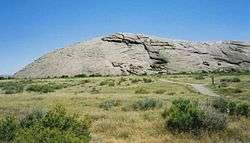
- Red Butte (940 miles (1,513 km) west) — Red Butte was the most tragic site of the Mormon Trail. After crossing the Platte River, the Martin Handcart Company camped near Red Butte as heavy snow fell. Snow continued to fall for three days, and the company came to a halt as many emigrants died. For nine days the company remained there, while 56 persons died from cold or disease. Finally, on October 28, an advance team of three men from the Utah rescue party reached them. The rescuers encouraged them that help was on the way and urged the company to start moving on.[18]
*Sweetwater River (964 miles (1,551 km) west) — From the last crossing of the Platte, the trail heads directly southwest toward Independence Rock, where it meets and follows the Sweetwater River to South Pass. To shorten the journey by avoiding the twists and turns of the river, the trail includes nine river crossings.[19][20]
Roadside settlements
The ranches and towns that settled alongside the Road provided outfitters from Missouri River towns places to sell their wares, and gave pioneers resting areas along the route. The following settlements appeared east to west along the Great Platte River Road in the Nebraska Territory.[21]
- Hook
- Fort Kearny
- Dobytown
- Platte
- 17 Mile
- Hopeful
- Craig
- Blondeau
- Thomas
- Freeman
- Mullaley
- Pinniston and Miller
- Midway
- Gilman
- Clark
- Machete
- McDonald
- Post Cottonwood
- Box Elder
- Cold Springs
- Bishop
- Fremont's Springs
- O'Fallon
- Williams
- Moore
- Alkali
- Sandhill
- Diamond Springs
- Beauvais
- Bueller
- Julesburg
- Camp Rankin
Conjoining routes
Trails, rails and highways that have used the Great Platte River Road include:
- Trapper's Trail
- Oregon Trail
- California Trail
- Mormon Trail
- Pony Express
- First Transcontinental Railroad
- Lincoln Highway
- U.S. Route 30
- Interstate 80
- Overland Trail
See also
References
- ↑ Mattes, M. (1987) The Great Platte River Road. University of Nebraska Press. p 6.
- ↑ "More About the Great Platte River Road", Nebraska State Historical Society. Retrieved 2008-03-28.
- ↑ Mattes, M. (1987) The Great Platte River Road. University of Nebraska Press. Chapter VII.
- ↑ The Pioneer Story. LDS.org. Retrieved 2006-05-22.
- ↑ Pages 149 to 203 The Fighting Cheyenne, George Bird Grinnell, University of Oklahoma Press (1956 original copyright 1915 Charles Scribner's Sons), hardcover, 454 pages
- ↑ "The Pioneer Story / Trail Location / Platte River". LDS.org. Retrieved 2006-05-22.
- ↑ Olson, J.C. and Naugle, R.C. (1997) History of Nebraska. University of Nebraska Press. p64.
- ↑ "The Pioneer Story / Trail Location / Fort Kearny". LDS.org. Retrieved 2006-05-24.
- ↑ "The Pioneer Story / Trail Location / Confluence Point". LDS.org. Retrieved 2006-05-29.
- ↑ "Great Platte River Road", Nebraska State Historical Society. Retrieved 2008-03-30.
- ↑ "The Pioneer Story / Trail Location / Ash Hollow". LDS.org. Retrieved 2006-05-30.
- ↑ "The Pioneer Story / Trail Location / Chimney Rock". LDS.org. Retrieved 2006-05-30.
- ↑ "The Pioneer Story / Trail Location / Scotts Bluff". LDS.org. Retrieved 2006-05-30.
- ↑ Hafen & Hafen (1992), p. 101
- ↑ "The Pioneer Story / Trail Location / Fort Laramie". LDS.org. Retrieved 2009-06-18.
- ↑ Hafen & Hafen (1992), pp. 108–109
- ↑ "The Pioneer Story / Trail Location / Upper Platte (Mormon) Ferry". LDS.org. Retrieved 2009-06-18.
- ↑ Hafen & Hafen (1992), pp. 110–115
- ↑ "The Pioneer Story / Trail Location / Sweetwater River". LDS.org. Retrieved 2009-06-18.
- ↑ "Ninth Crossing of the Sweetwater (Burnt Ranch)". Wyoming State Historic Preservation Office. Retrieved 2009-06-18.
- ↑ Becher, R. (1999) Massacre Along the Medicine Road: A Social History of the Indian War. Caxton Press. p 246.