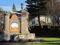
Astoria, Oregon
| Astoria, Oregon | ||
|---|---|---|
| City | ||
|
Astoria and the Astoria–Megler Bridge | ||
| ||
 Location in Oregon | ||
 Astoria, Oregon Location in the United States | ||
| Coordinates: 46°11′20″N 123°49′16″W / 46.18889°N 123.82111°WCoordinates: 46°11′20″N 123°49′16″W / 46.18889°N 123.82111°W | ||
| Country | United States | |
| State | Oregon | |
| County | Clatsop | |
| Founded | 1811 | |
| Incorporated | 1876[1] | |
| Government | ||
| • Mayor | Arline J. LaMear (D)[2] | |
| Area[3] | ||
| • Total | 10.11 sq mi (26.18 km2) | |
| • Land | 6.16 sq mi (15.95 km2) | |
| • Water | 3.95 sq mi (10.23 km2) | |
| Elevation | 23 ft (7 m) | |
| Population (2010)[4] | ||
| • Total | 9,477 | |
| • Estimate (2012[5]) | 9,527 | |
| • Density | 1,538.5/sq mi (594.0/km2) | |
| Time zone | PST (UTC-8) | |
| • Summer (DST) | PDT (UTC-7) | |
| ZIP code | 97103 | |
| Area code(s) | 503 and 971 | |
| FIPS code | 41-03150[6] | |
| GNIS feature ID | 1117076[7] | |
| Website | www.astoria.or.us | |


Astoria is the seat of Clatsop County, Oregon, United States.[8] Situated near the mouth of the Columbia River, the city was named after the American investor John Jacob Astor. His American Fur Company founded Fort Astoria at the site in 1811, 205 years ago. Astoria was incorporated by the Oregon Legislative Assembly on October 20, 1876.[1]
It holds the distinction of being the first permanent United States settlement on the Pacific coast and for having the first U.S. post office west of the Rocky Mountains.
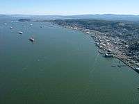
Located on the south shore of the Columbia River, the city is served by the deepwater Port of Astoria. Transportation includes the Astoria Regional Airport with U.S. Route 30 and U.S. Route 101 as the main highways, and the 4.1-mile (6.6 km) Astoria–Megler Bridge connecting to neighboring Washington across the river. The population was 9,477 at the 2010 census.[9]
History
19th century
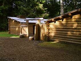
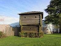
The Lewis and Clark Expedition spent the winter of 1805–06 at Fort Clatsop, a small log structure south and west of modern-day Astoria. The expedition had hoped a ship would come by to take them back east, but instead they endured a torturous winter of rain and cold, later returning the way they came.[10] Today the fort has been recreated and is now a historical park.[11]
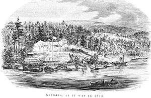
In 1811, British explorer David Thompson, the first person known to have navigated the entire length of the Columbia River, reached the partially constructed Fort Astoria near the mouth of the river. He arrived just two months after the Pacific Fur Company's ship, the Tonquin.[12] The fort constructed by the Tonquin party established Astoria as a U.S., rather than a British, settlement.[13] It became a vital post for American exploration of the continent and was later used as an American claim in the Oregon boundary dispute with other European nations.
The Pacific Fur Company, a subsidiary of John Jacob Astor's American Fur Company, was created to begin fur trading in the Oregon Country.[14] During the War of 1812, in 1813, the company's officers sold its assets to their Canadian rivals, the North West Company. The fur trade would remain under British control until U.S. pioneers following the Oregon Trail began filtering into the town in the mid-1840s. The Treaty of 1818 established joint U.S. – British occupancy of the Oregon Country.[15] [16] In 1846, the Oregon Treaty divided the mainland at the 49th parallel north, and the southern portion of Vancouver Island south of this line was awarded to the British.[17]
| ||||


_ASTORIA%2C_OREGON%2C_ENTRANCE_TO_COLUMBIA_RIVER.jpg)
Washington Irving, a prominent American writer with a European reputation, was approached by John Jacob Astor to mythologize the three-year reign of his Pacific Fur Company. Astoria (1835), written while Irving was Astor's guest, cemented the importance of the region in the American psyche.[18] In Irving's words, the fur traders were "Sinbads of the wilderness", and their venture was a staging point for the spread of American economic power into both the continental interior and into the Pacific.[19]
An Astoria Salmon cannery.
As the Oregon Territory grew and became increasingly more colonized by Americans, Astoria likewise grew as a port city near the mouth of the great river that provided the easiest access to the interior. The first U.S. post office west of the Rocky Mountains was established in Astoria in 1847[20] and official state incorporation in 1876.[1]
Astoria attracted a host of immigrants beginning in the late 19th century: Nordic settlers, primarily Finns, and Chinese soon became larger parts of the population. The Finns mostly lived in Uniontown, near the present-day end of the Astoria–Megler Bridge, and took fishing jobs; the Chinese tended to do cannery work, and usually lived either downtown or in bunkhouses near the canneries. By the late 1800s, 22% of Astoria's population was Chinese.[21]
20th and 21st centuries
In 1883, and again in 1922, downtown Astoria was devastated by fire, partly because it was mostly wood and entirely raised off the marshy ground on pilings. Even after the first fire, the same format was used, and the second time around the flames spread quickly again, as collapsing streets took out the water system. Frantic citizens resorted to dynamite, blowing up entire buildings to stop the fire from going further.[22][23]
| Panoramic views of Astoria in the early 20th century |
|---|
 |
 |
| |
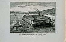
Astoria has served as a port of entry for over a century and remains the trading center for the lower Columbia basin, although it has long since been eclipsed by Portland, Oregon, and Seattle, Washington, as an economic hub on the coast of the Pacific Northwest. Astoria's economy centered on fishing, fish processing, and lumber. In 1945, about 30 canneries could be found along the Columbia; however, in 1974, the Bumblebee Seafood corporation moved its headquarters out of Astoria and gradually reduced its presence until closing its last Astoria cannery in 1980.[24] The lumber industry likewise declined; Astoria Plywood Mill, the city's largest employer, closed in 1989, and the Burlington Northern and Santa Fe Railway discontinued service to Astoria in 1996.[25]
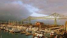
From 1921 to 1966, a ferry route across the Columbia River connected Astoria with Pacific County, Washington. In 1966, the Astoria–Megler Bridge was opened. The bridge completed U.S. Route 101 and linked Astoria with Washington on the opposite shore of the Columbia, replacing the ferry service.[26]
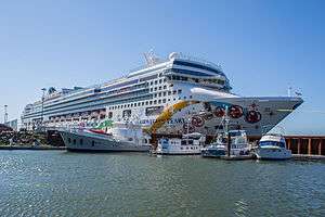
Today, tourism, Astoria's growing art scene, and light manufacturing are the main economic activities of the city. Logging and fishing persist, but at a fraction of their former levels.[27] It is a port of call for cruise ships since 1982, after $10 million in pier improvements to accommodate these larger ships. To avoid Mexican ports of call during the Swine Flu outbreak of 2009, many cruises were re-routed to include Astoria. The residential community The World visited Astoria in June 2009.[28] The town's seasonal sport fishing tourism has been active for several decades[29] [30] [31] and has now been supplanted with visitors coming for the historic elements of the city. The more recent microbrewery/brewpub scene[32] and a weekly street market[33] have helped popularized the area as a destination.
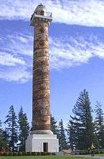
In addition to the replicated Fort Clatsop, another point of interest is the Astoria Column, a tower 125 feet (38 m) high, built atop Coxcomb Hill above the town, with an inner circular staircase allowing visitors to climb to see a panoramic view of the town, the surrounding lands, and the Columbia flowing into the Pacific. The tower was built in 1926 with financing by the Great Northern Railway and Vincent Astor of the Astor family, the great-grandson of John Jacob Astor, in commemoration of the city's role in the family's business history and the region's early history.[34][35]
Since 1998, artistically-inclined fishermen and women from Alaska and the Pacific Northwest have traveled to Astoria for the Fisher Poets Gathering, where poets and singers tell their tales to honor the fishing industry and lifestyle.[36]
Astoria is also the western terminus of the TransAmerica Bicycle Trail, a 4,250 miles (6,840 km) coast-to-coast bicycle touring route created in 1976 by the Adventure Cycling Association.[37]
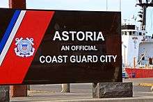
Three United States Coast Guard cutters: the Steadfast, Alert, and Fir, call the port of Astoria home.[38]
Geography
According to the United States Census Bureau, the city has a total area of 10.11 square miles (26.18 km2), of which, 6.16 square miles (15.95 km2) is land and 3.95 square miles (10.23 km2) is water.[3]
Climate
Astoria lies within the Mediterranean climate zone (Köppen Csb), with very mild temperatures year-round, some of the most consistent in the contiguous United States; winters are mild for this latitude (it usually remains above freezing at night) and wet. Summers are cool, although short heat waves can occur. Rainfall is most abundant in late fall and winter and is lightest in July and August, averaging approximately 67 inches (1,700 mm) of rain each year.[39] Snowfall is relatively rare, occurring in only three-fifths of years. Nevertheless, when conditions are ripe, significant snowfalls can occur.
Astoria is tied with Lake Charles, Louisiana, and Port Arthur, Texas, as the most humid city in the contiguous United States. The average relative humidity in Astoria is 89% in the morning and 73% in the afternoon.[40]
Annually, there is an average of only 4.2 days with temperatures reaching 80 °F (27 °C) or higher, and 90 °F (32 °C) readings are rare. Normally there are only one or two nights per year when the temperature remains at or above 60 °F (16 °C).[41] There are an average of 31 days with minimum temperatures at or below the freezing mark. The record high temperature was 101 °F (38 °C) on July 1, 1942. The record low temperature was 6 °F (−14 °C) on December 8, 1972, and on December 21, 1990.
There are an average of 191 days with measurable precipitation. The wettest year was 1950 with 113.34 inches (2,879 mm) and the driest year was 1985 with 41.58 inches (1,056 mm). The most rainfall in one month was 36.07 inches (916 mm) in December 1933, and the most in 24 hours was 5.56 inches (141 mm) on November 25, 1998.[42] The most snowfall in one month was 26.9 inches (68 cm) in January 1950,[43][44] and the most snow in 24 hours was 12.5 inches (32 cm) on December 11, 1922.[42]
| Climate data for Astoria, Oregon (1981–2010) | |||||||||||||
|---|---|---|---|---|---|---|---|---|---|---|---|---|---|
| Month | Jan | Feb | Mar | Apr | May | Jun | Jul | Aug | Sep | Oct | Nov | Dec | Year |
| Record high °F (°C) | 70 (21) |
75 (24) |
80 (27) |
83 (28) |
93 (34) |
99 (37) |
101 (38) |
98 (37) |
95 (35) |
85 (29) |
73 (23) |
67 (19) |
101 (38) |
| Average high °F (°C) | 49.8 (9.9) |
51.6 (10.9) |
53.8 (12.1) |
56.4 (13.6) |
60.4 (15.8) |
63.9 (17.7) |
67.4 (19.7) |
68.7 (20.4) |
67.6 (19.8) |
60.9 (16.1) |
53.5 (11.9) |
48.7 (9.3) |
58.6 (14.8) |
| Average low °F (°C) | 37.7 (3.2) |
37.2 (2.9) |
38.9 (3.8) |
41.0 (5) |
45.6 (7.6) |
50.0 (10) |
53.1 (11.7) |
53.1 (11.7) |
49.4 (9.7) |
44.2 (6.8) |
40.1 (4.5) |
36.6 (2.6) |
43.9 (6.6) |
| Record low °F (°C) | 11 (−12) |
9 (−13) |
22 (−6) |
24 (−4) |
28 (−2) |
32 (0) |
37 (3) |
33 (1) |
33 (1) |
26 (−3) |
15 (−9) |
6 (−14) |
6 (−14) |
| Average precipitation inches (mm) | 10.20 (259.1) |
7.19 (182.6) |
7.45 (189.2) |
5.20 (132.1) |
3.31 (84.1) |
2.55 (64.8) |
1.03 (26.2) |
1.16 (29.5) |
2.14 (54.4) |
5.98 (151.9) |
11.15 (283.2) |
9.88 (251) |
67.24 (1,708.1) |
| Average snowfall inches (cm) | 0.5 (1.3) |
0.3 (0.8) |
0 (0) |
0 (0) |
0 (0) |
0 (0) |
0 (0) |
0 (0) |
0 (0) |
0 (0) |
0.2 (0.5) |
0.1 (0.3) |
1.1 (2.9) |
| Average precipitation days (≥ 0.01 in) | 21.4 | 17.7 | 21.0 | 18.4 | 16.4 | 13.2 | 8.3 | 7.4 | 9.4 | 15.9 | 21.4 | 20.6 | 191.1 |
| Average snowy days (≥ 0.1 in) | 0.4 | 0.4 | 0 | 0 | 0 | 0 | 0 | 0 | 0 | 0 | 0.1 | 0.2 | 1.1 |
| Source: NOAA (extremes 1892–present)[42] | |||||||||||||
Demographics
| Historical population | |||
|---|---|---|---|
| Census | Pop. | %± | |
| 1860 | 252 | — | |
| 1870 | 639 | 153.6% | |
| 1880 | 2,803 | 338.7% | |
| 1890 | 6,184 | 120.6% | |
| 1900 | 8,351 | 35.0% | |
| 1910 | 9,599 | 14.9% | |
| 1920 | 14,027 | 46.1% | |
| 1930 | 10,349 | −26.2% | |
| 1940 | 10,389 | 0.4% | |
| 1950 | 12,331 | 18.7% | |
| 1960 | 11,239 | −8.9% | |
| 1970 | 10,244 | −8.9% | |
| 1980 | 9,998 | −2.4% | |
| 1990 | 10,069 | 0.7% | |
| 2000 | 9,813 | −2.5% | |
| 2010 | 9,477 | −3.4% | |
| Est. 2015 | 9,626 | [45] | 1.6% |
| Sources:[9][46][47] | |||
2010 census
As of the census[4] of 2010, there were 9,477 people, 4,288 households, and 2,274 families residing in the city. The population density was 1,538.5 inhabitants per square mile (594.0/km2). There were 4,980 housing units at an average density of 808.4 per square mile (312.1/km2). The racial makeup of the city was 89.2% White, 0.6% African American, 1.1% Native American, 1.8% Asian, 0.1% Pacific Islander, 3.9% from other races, and 3.3% from two or more races. Hispanic or Latino of any race were 9.8% of the population.
There were 4,288 households of which 24.6% had children under the age of 18 living with them, 37.9% were married couples living together, 10.8% had a female householder with no husband present, 4.3% had a male householder with no wife present, and 47.0% were non-families. 38.8% of all households were made up of individuals and 15.1% had someone living alone who was 65 years of age or older. The average household size was 2.15 and the average family size was 2.86.
The median age in the city was 41.9 years. 20.3% of residents were under the age of 18; 8.6% were between the ages of 18 and 24; 24.3% were from 25 to 44; 29.9% were from 45 to 64; and 17.1% were 65 years of age or older. The gender makeup of the city was 48.4% male and 51.6% female.
2000 census
As of the census[6] of 2000, there were 9,813 people, 4,235 households, and 2,469 families residing in the city. The population density was 1,597.6 people per square mile (617.1 per km²). There were 4,858 housing units at an average density of 790.9 per square mile (305.5 per km²). The racial makeup of the city was:
- 91.08% White
- 0.52% Black or African American
- 1.14% Native American
- 1.94% Asian
- 0.19% Pacific Islander
- 2.67% from other races
- 2.46% from two or more races
5.98% of the population were Hispanic or Latino of any race.
14.2% were of German, 11.4% Irish, 10.2% English, 8.3% United States or American, 6.1% Finnish, 5.6% Norwegian, and 5.4% Scottish ancestry according to Census 2000.
There were 4,235 households out of which 28.8% had children under the age of 18 living with them, 43.5% were married couples living together, 11.2% had a female householder with no husband present, and 41.7% were non-families. 35.4% of all households were made up of individuals and 13.6% had someone living alone who was 65 years of age or older. The average household size was 2.26 and the average family size was 2.93.
In the city the population was spread out with:
- 24.0% under the age of 18
- 9.1% from 18 to 24
- 26.4% from 25 to 44
- 24.5% from 45 to 64
- 15.9% 65 years of age or older.
The median age was 38 years. For every 100 females there were 92.3 males. For every 100 females age 18 and over, there were 89.9 males.
The median income for a household in the city was $33,011, and the median income for a family was $41,446. Males had a median income of $29,813 versus $22,121 for females. The per capita income for the city was $18,759. About 11.6% of families and 15.9% of the population were below the poverty line, including 22.0% of those under age 18 and 9.6% of those age 65 or over.
Government
Astoria operates under a council–manager form of city government. Voters elect four councilors by ward and a mayor, who each serve four-year terms.[48] The mayor and council appoint a city manager to conduct the ordinary business of the city.[48] The current mayor is Arline LaMear, who took office on January 5, 2015.[49] Her predecessor, Willis Van Dusen, served as mayor for 24 years, starting in 1991.[50]
Education
The Astoria School District has four primary and secondary schools, including Astoria High School. Clatsop Community College is the city's two-year college. It also has a library and many parks with historical significance. As well as the second oldest Job Corps facility, Tongue Point Job Corps.
-
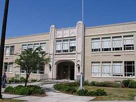
John Jacob Astor Elementary School
-
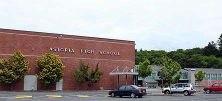
Astoria High School
-
_(clatDA0040).jpg)
Robert Gray School (Astoria High School Alternative School)
Media
The Daily Astorian is the main newspaper serving Astoria, it was established nearly 144 years ago, in 1873,[51] and has been in publication continuously since that time.[52] The Coast River Business Journal is a monthly business magazine covering Astoria, Clatsop County, and the Northwest Oregon coast. It, as with The Daily Astorian, is part of the EO Media Group (formerly the East Oregonian Publishing Company) family of Oregon and Washington newspapers.[53] The local NPR station is KMUN 91.9, and KAST 1370 is a local news-talk radio station.
In popular culture
Shanghaied in Astoria is a musical about Astoria's history that has been performed in Astoria every year since 1984.[54]
Astoria was the setting of the 1985 film The Goonies, which was filmed on location. Other movies filmed in Astoria include Short Circuit, The Black Stallion, Kindergarten Cop, Free Willy, Free Willy 2: The Adventure Home, Teenage Mutant Ninja Turtles III, Benji the Hunted, The Ring Two, Into the Wild, The Guardian and Cthulhu.[55][56][57][58]
The early 1960s television series Route 66 filmed the episode entitled "One Tiger to a Hill"[59] in Astoria; it was broadcast on September 21, 1962.
Pop punk band The Ataris' fourth album was titled So Long, Astoria as an allusion to The Goonies. A song of the same title is the album's first track. The album's back cover features news clippings from Astoria, including a picture of the port's water tower from a 2002 article on its demolition.[60]
Warships named Astoria
_off_Mare_Island_in_July_1941.jpg)
Two US Navy Cruisers were named USS Astoria: A New Orleans-class heavy cruiser (CA-34) and a Cleveland-class light cruiser (CL-90). The former was lost in combat in August 1942 at the World War II Pacific ocean Battle of Savo Island,[61] and the latter was scrapped in 1971 after being removed from active duty in 1949.[62]
Museums and other points of interest

.jpg)
_(clatDA0016).jpg)
.jpg)
.jpg)
_(clatDA0016a).jpg)
.jpg)
_(clatD0067).jpg)
- Columbia River Maritime Museum
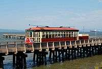
- Astoria Riverfront Trolley
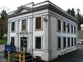
- Clatsop County Historical Society Heritage Museum, located in the Old City Hall
- Astoria Regional Airport
- Clatsop Spit
- CGAS Astoria
- Oregon Film Museum
- Captain George Flavel House Museum
- The Astoria Column (the highest point in Astoria)
Sister cities
Astoria has one sister city,[63] as designated by Sister Cities International:
 Walldorf, Germany, which is the birthplace of Astoria's namesake, John Jacob Astor, who was born in Walldorf near Heidelberg on July 17, 1763. The sistercityship was founded on Astor's 200th birthday in 1963 in Walldorf by Walldorf's mayor Wilhelm Willinger and Astoria's mayor Harry Steinbock.[64]
Notable people
- Bobby Anet, college basketball guard who helped guide the University of Oregon to win the inaugural NCAA Men's Division I Basketball Tournament championship in 1938–39 attended Astoria High school.[65]
- Jona Bechtolt, is an electronic musician and multimedia artist raised in Astoria.
- Del Bjork, a professional American football offensive lineman in the National Football League (NFL). He played two seasons for the Chicago Bears (1937–1938).
- Brian Bruney, Major League Baseball relief pitcher.[66]
- Marie Dorion, the only female member of an overland expedition sent by the Pacific Fur Company to Fort Astoria in 1810.[67]
- Clark Gable, actor, began his career at the Astoria Theatre in 1922.[68]
- Jerry Gustafson, football player.[69]
- Darrell Hanson, American politician in the state of Iowa.
- Michael Hurley, American singer/songwriter.[70]
- Duane Jarvis, American guitarist and singer/songwriter.
- Wally Johansen, a college basketball guard who played for the University of Oregon when it won the inaugural NCAA Men's Division I Basketball Tournament championship in 1938–39.
- Consuelo Kanaga, a photographer and writer who became well known for her photographs of African-Americans.
- Augustus C. Kinney, a physician and scientist, was a leading expert on tuberculosis.
- Kenneth Koe, chemist of Chinese descent, helped develop sertraline, which was branded and sold as Zoloft.
- Carl W. Leick, a German born architect who moved to Astoria. His Astoria designs include the Captain George Flavel House, the Clatsop County Courthouse, and the Grace Episcopal Church.[71]
- Armand Lohikoski, American born – Finnish movie director and writer.
- Robert Lundeen, American businessperson, most notable for his association with the College of Engineering at Oregon State University (OSU) and Tektronix Inc.[72]
- Ranald MacDonald, first man to teach the English language in Japan and one of the interpreters between the Tokugawa shogunate and Commodore Perry when the latter made his trips to Japan on behalf of the US government in the early 1850s.
- Holly Madison, Playboy Magazine model and one of Hugh Hefner's ex-girlfriends,[73] born in Astoria but left before her 2nd birthday.
- Donald Malarkey, World War II U.S. Army soldier of the 101st Airborne Division who was portrayed in the TV series Band of Brothers.[74]
- Royal Nebeker, American painter and print maker. Lived and worked in Astoria for 30 years.
- Albin W. Norblad, Attorney in the U.S. state of Oregon, and a judge of the Oregon Circuit Court for the 3rd judicial district.
- Kerttu Nuorteva, A Soviet intelligence agent during World War II. Daughter of Santeri Nuorteva.
- Santeri Nuorteva, Finnish socialist politician and journalist, who edited Toveri ("The Comrade") in Astoria in 1912–1913.[75] Father of Kerttu Nuorteva.
- Maila Nurmi, a.k.a. 1950s TV horror hostess Vampira and co-star of Ed Wood's Plan 9 from Outer Space attended Astoria High School in the late 1930s.[76]
- Leroy E. "Ed" Parsons, referred to as the "Father of Cable Television"; he developed one of the first community antenna television stations (CATV) in the United States in Astoria.[77]
- Mike Pecarovich, American college football coach, lawyer, and actor.
- Jordan Poyer, NFL football player, raised in Astoria and played for Astoria teams.[78]
- Ken Raymond, an expert in bioinorganic and coordination chemistry.
- Sacagawea, a Lemhi Shoshone. The only female member of the Lewis and Clark Expedition to the Pacific in 1804–06.
- Arnie Sundberg, American weightlifter who competed in the 1932 Summer Olympics.
- Gary Wilhelms, American politician who was a member of the Oregon House of Representatives.
- Stanley Paul Young, American biologist.[79]
- Eric Zener, American photorealist artist best known for figure paintings of lone subjects, often in or about swimming pools.
See also
- The Clatsop tribe of Native Americans
- The Finnish Socialists of Astoria
- Western Workmen's Co-operative Publishing Company
- Columbia Memorial Hospital
- Astoria Regional Airport
- National Register of Historic Places listings in Clatsop County, Oregon - 43 Astoria structures & districts listed (2016)
References
- 1 2 3 Leeds, W. H. (1899). "Special Laws". The State of Oregon General and Special Laws and Joint Resolutions and Memorials Enacted and Adopted by the Twentieth Regular Session of the Legislative Assembly. Salem, Oregon: State Printer: 747.
- ↑ "Arline LaMear". Democratic Party of Oregon. Retrieved October 2, 2015.
- 1 2 "US Gazetteer files 2010". United States Census Bureau. Archived from the original on January 24, 2012. Retrieved December 21, 2012.
- 1 2 "American FactFinder". United States Census Bureau. Retrieved December 21, 2012.
- ↑ "Population Estimates". United States Census Bureau. Archived from the original on June 17, 2013. Retrieved June 2, 2013.
- 1 2 "American FactFinder". United States Census Bureau. Archived from the original on September 11, 2013. Retrieved January 31, 2008.
- ↑ "US Board on Geographic Names". United States Geological Survey. October 25, 2007. Retrieved January 31, 2008.
- ↑ "Find a County". National Association of Counties. Archived from the original on May 31, 2011. Retrieved June 7, 2011.
- 1 2 "2010 Census profiles: Oregon cities alphabetically A-C" (PDF). Portland State University Population Research Center. Retrieved June 12, 2011.
- ↑ William Clark; Meriwether Lewis (2015). "The Journals of Lewis and Clark, 1804–1806" (Library of Alexandria ed.). ISBN 1-613-10310-7.
- ↑ "History & Culture: Places: Fort Clatsop – The National Park Service maintains a replica fort within the Lewis and Clark National Historical Park that is believed to sit on or near the site of the original fort.". National Park Service / U.S. Department of the Interior. Retrieved May 12, 2016.
- ↑ Meinig, D.W. (1995) [1968]. The Great Columbia Plain (Weyerhaeuser Environmental Classic ed.). University of Washington Press. pp. 37–38, 50. ISBN 978-0-295-97485-9.
- ↑ Meinig, D.W. (1995) [1968]. The Great Columbia Plain (Weyerhaeuser Environmental Classic ed.). Seattle, Washington: University of Washington Press. pp. 37–38, 50. ISBN 0-295-97485-0.
- ↑ Ronda, James (1995). Astoria & Empire. Lincoln, NE: University of Nebraska Press. ISBN 0-8032-3896-7.
- ↑ United States Department of State (November 1, 2007). Treaties In Force: A List of Treaties and Other International Agreements of the United States in Force on November 1, 2007. Section 1: Bilateral Treaties (PDF). Compiled by the Treaty Affairs Staff, Office of the Legal Adviser, U.S. Department of State. (2007 ed.). Washington, DC. p. 320. Retrieved May 23, 2008.
- ↑ Lauterpacht, Elihu, et al., ed. (2004). "Consolidated Table of Treaties, Volumes 1–125" (PDF). In Elihu Lauterpacht; C. J. Greenwood; A. G. Oppenheimer; Karen Lee. International Law Reports:. Cambridge University Press. p. 8. ISBN 0-521-80779-4. Retrieved March 27, 2006.
- ↑ "Convention of Commerce between His Majesty and the United States of America.—Signed at London, 20th October 1818". Canado-American Treaties. Université de Montréal. 2000. Archived from the original on April 11, 2009. Retrieved March 27, 2006.
- ↑ In his Introduction to the rambling work, Irving reports that Astor explicitly "expressed a regret that the true nature and extent of his enterprizeand its national character and importance had never been understood."
- ↑ Collections of the Kansas State Historical Society, Volume 9. Kansas State Historical Society. 1906.
- ↑ "Oregon Territorials - Oregon Sesquicentennial exhibit online version.pdf" (PDF). Pacific Northwest Postal History Society. 2009. Retrieved November 11, 2014.
- ↑ Chelsea Gorrow (April 16, 2012). "Astoria Embraces Chinese Legacy". The Daily Astorian.
- ↑ Terry, John (December 25, 2010). "Infernos leave historic marks on Astoria's waterfront". The Oregonian/OregonLive.
- ↑ Dresbeck, Rachel (Jul 15, 2015). "Chapter 3 - Port Town In Flames - The Astoria Fire - 1922". Oregon Disasters: True Stories of Tragedy and Survival. Rowman & Littlefield. Retrieved May 30, 2016.
- ↑ "South Tongue Point Land Exchange and Marine Industrial Park Development Project, Clatsop County: Environmental Impact Statement – "... Bumblebee Seafood plant closed in 1982 (Powell, Goss & Associates, 1990)."".
- ↑ Anderson, John Gottberg (June 21, 2015). "Going "Goonie" in Astoria". Bend Bulletin.
- ↑ Smith, Dwight A.; Norman, James B.; Dykman, Pieter T. (1989). Historic Highway Bridges of Oregon. Oregon Historical Society Press. p. 299. ISBN 0-87595-205-4.
- ↑ "Report: Astoria tops West Coast fishing ports". The Associated Press. October 29, 2014.
- ↑ Muldoon, Katy (May 14, 2009). "Swine flu sends cruise ship, tourism dollars to Astoria". The Oregonian/OregonLive.
- ↑ Edward Stratton (August 11, 2015). "Keeping fishing fever in check". the Daily Astorian. Retrieved May 30, 2016.
- ↑ Bill Monroe (August 8, 2015). "Early success at Buoy 10 promises good fall season ahead for salmon fishing". The Oregonian/OregonLive. Retrieved May 30, 2016.
- ↑ Andrew McKean (August 2015). "The Bite: Salmon Fishing the Columbia River". Outdoor Life. Retrieved May 30, 2016.
- ↑ Edward Stratton (May 24, 2016). "Sour beer to join Astoria's impressive brewing lineup". the daily astorian. Retrieved May 30, 2016.
- ↑ "Astoria Sunday Market - Astoria, OR". National Farmers Market Directory. Retrieved May 30, 2016.
- ↑ "Astoria Column, Coxcomb Hill". Spokesman-Review. Spokane, Washington. Associated Press. July 13, 1926. p. 7.
- ↑ "The Column at Astoria". Eugene Guard. Oregon. July 24, 1926. p. 4.
- ↑ Sharon Boorstin (June 2005). "Rhyme or Cut Bait When these fisher poets gather, nobody brags about the verse that got away". Smithsonian Magazine.
- ↑ "TransAmerica Trail Summary". Adventure Cycling Association. Retrieved December 26, 2012.
- ↑ Edward Stratton (September 16, 2015). "New commander takes Steadfast's helm". EO Media Group / chinookobserver. Retrieved May 12, 2016.
- ↑ "Climate of Clatsop County". Oregon State University. Retrieved April 22, 2016.
- ↑ "Average Relative Humidity – Morning (M), Afternoon (A)" (PDF). Comparative Climatic Data for the United States Through 2012. National Oceanic and Atmospheric Administration. 2013.
- ↑ "Station Name: OR ASTORIA RGNL AP". National Oceanic and Atmospheric Administration. Retrieved June 13, 2013.
- 1 2 3 "NOWData – NOAA Online Weather Data". National Oceanic and Atmospheric Administration. Retrieved November 26, 2012.
- ↑ "Astoria, Oregon (350324)". Western Regional Climate Center. Retrieved December 31, 2013.
- ↑ "Astoria WSO Airport, Oregon (350328)". Western Regional Climate Center. Retrieved December 31, 2013.
- ↑ "Annual Estimates of the Resident Population for Incorporated Places: April 1, 2010 to July 1, 2015". Retrieved July 2, 2016.
- ↑ Moffat, Riley. Population History of Western U.S. Cities & Towns, 1850–1990. Lanham: Scarecrow, 1996, 206.
- ↑ "Subcounty population estimates: Oregon 2000–2007" (CSV). United States Census Bureau, Population Division. March 18, 2009. Archived from the original on May 15, 2009. Retrieved May 3, 2009.
- 1 2 "City Council". City of Astoria. Retrieved December 22, 2015.
- ↑ DePledge, Derrick (January 6, 2015). "LaMear takes power at City Hall". The Daily Astorian. Retrieved December 22, 2015.
- ↑ Forrester, Steve (December 16, 2014). "Hurrah! Hurrah! Hurrah! City, council honors retiring Mayor Willis Van Dusen". The Daily Astorian. Retrieved December 22, 2015.
- ↑ Newspapers Published in Oregon Oregon Blue Book. Retrieved July 22, 2012.
- ↑ "Oregon Newspaper Publishers Century Roster" (PDF). Oregon Publisher. The Oregon Newspaper Publishers Association. June 2012. p. 7. Archived from the original (PDF) on June 19, 2012. Retrieved November 25, 2014.
- ↑ "Coast River Business Journal - About Us". Retrieved May 30, 2016.
- ↑ "Entertainment". The Daily Astorian. Retrieved February 27, 2008.
- ↑ Sonja Stewart (May 16, 2011). "Visit Your Favorite Family Movie Locations in Astoria, Oregon". Parenting Squad. Retrieved March 3, 2014.
- ↑ "Movies filmed in Astoria Oregon". Astoria Oregon. Retrieved March 3, 2014.
- ↑ Ryan S. (aka Spoodawg) (July 8, 2010). "Guest blogger: How did I spend my vacation? Visiting 'Goonies' filming locations!". USA Today. Retrieved March 3, 2014.
- ↑ "Filmed in Oregon 1908–2012" (PDF). (Oregon) Governor's Office of Film & Television. Retrieved March 3, 2014.
- ↑ "One Tiger to a Hill". September 21, 1962 – via IMDb.
- ↑ KATIE KARPOWICZ. "The Ataris Hop On The Nostalgia Boat, Bring 'So Long, Astoria' Tour To Chicago". Gothamist LLC. Retrieved May 13, 2016.
- ↑ Joe James Custer (1944). Through the Perilous Night: The Astoria's Last Battle. The Macmillan Company.
- ↑ "Astoria III (CL-90)". Naval History and Heritage Command. June 19, 2015. Retrieved December 12, 2015.
- ↑ "Interactive City Directory". Sister Cities International. Retrieved December 31, 2013.
- ↑ Ebeling, Herbert C. (1998). Johann Jakob Astor, Walldorf Astor-Stiftung. pp. 351–354. ISBN 3-00-003749-7.
- ↑ AHS Hall of Fame
- ↑ "Brian Bruney Stats". Baseball Almanac. Retrieved December 31, 2013.
- ↑ Lynn, Capi (April 5, 2005). "'She Should Be As Famous As Sacagawea'". Statesman-Journal. Salem, Oregon: Gannett. Retrieved October 24, 2008.
- ↑ "Astoria Theatre Sign". Retrieved June 9, 2009.
- ↑ "Jerry F. Gustafson". fanbase.com. Retrieved August 9, 2014.
- ↑ Brinkman, Brian R. (May 11, 2011). "Wading in cerebrospinal fluid with Cass McCombs, Frank Fairfield and Michael Hurley". Oregon Music News. Archived from the original on January 2, 2014. Retrieved December 31, 2013.
- ↑ "National Register of Historic Places Nomination and Registration Forms: Mukilteo Light Station" (PDF). National Park Service. October 21, 1977. Retrieved June 8, 2015.
- ↑ "Lundeen Made Lasting Impact at Oregon State". Retrieved May 11, 2016.
- ↑ TMZ.com (October 7, 2008). "Holly to Hugh: Hef Off". Retrieved October 7, 2008.
- ↑ NW Spotlight (November 11, 2011). "Veterans Day tribute to an Oregon hero: Don Malarkey". OregonCatalyst. Retrieved December 31, 2013.
- ↑ Paul George Hummasti, Finnish Radicals in Astoria, Oregon, 1904–1940: A Study in Immigrant Socialism. New York: Arno Press, 1979; p. 44.
- ↑ "Vampira: The haunting of Astoria High School". The Daily Astorian. October 31, 2008. Retrieved December 31, 2013.
- ↑ John, Finn J.D. (September 19, 2011). "Astoria man set out to do something nice for his wife, ended up inventing cable TV". Offbeat Oregon History. Retrieved December 31, 2013.
- ↑ "Small-town Jordan Poyer hopes to make it big time with the Cleveland Browns as a defensive back".
- ↑ "Biography". Smithsonian Institution Archives. Retrieved June 19, 2013.
Further reading
- Ebeling, Herbert C.: Johann Jakob Astor. Walldorf, Germany: Astor-Stiftung, 1998. ISBN 3-00-003749-7.
- Leedom, Karen L.: Astoria: An Oregon History. Astoria, Oregon: Rivertide Publishing, 2008. ISBN 978-0-9826252-1-7.
- MacGibbon, Elma (1904). Leaves of knowledge. Shaw & Borden Co. Elma MacGibbons reminiscences about her travels in the United States starting in 1898, which were mainly in Oregon and Washington. Includes chapter "Astoria and the Columbia River."
External links
| Wikimedia Commons has media related to Astoria, Oregon. |
 Astoria travel guide from Wikivoyage
 "Astoria". Encyclopædia Britannica (11th ed.). 1911.
- Entry for Astoria in the Oregon Blue Book
- Astoria-Warrenton Chamber of Commerce
- Astoria Documentary produced by Oregon Public Broadcasting
Municipalities and communities of Clatsop County, Oregon, United States | ||
|---|---|---|
| Cities | 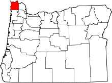 | |
| CDPs | ||
| Other unincorporated communities | ||