Scotts Bluff National Monument
| Scotts Bluff National Monument | |
|---|---|
|
IUCN category V (protected landscape/seascape) | |
|
Covered Wagon on the Oregon Trail at Scotts Bluff | |
 Scotts Bluff | |
| Location | Scotts Bluff County, Nebraska, USA |
| Nearest city | Gering, Nebraska |
| Coordinates | 41°50′05″N 103°42′26″W / 41.83472°N 103.70722°WCoordinates: 41°50′05″N 103°42′26″W / 41.83472°N 103.70722°W[1] |
| Area | 3,005 acres (4.695 sq mi; 1,216 ha)[2] |
| Created | December 12, 1919 |
| Visitors | 128,811 (in 2011)[3] |
| Governing body | National Park Service |
| Website | Scotts Bluff National Monument |
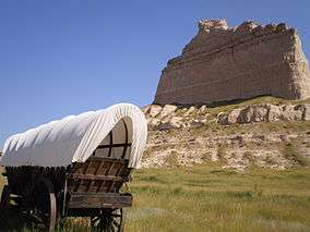
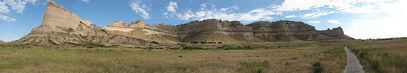
Scotts Bluff National Monument in western Nebraska includes an important 19th-century landmark on the Oregon Trail and Mormon Trail. The National Monument contains multiple bluffs (steep hills) located on the south side of the North Platte River; it is named for one prominent bluff called Scotts Bluff, which rises over 800 feet (240 m) above the plains at its highest point. The monument is composed of five rock formations named Crown Rock, Dome Rock, Eagle Rock, Saddle Rock, and Sentinel Rock.
Scotts Bluff County and the city of Scottsbluff, Nebraska, were named after the landmark.[4]
History
The collection of bluffs was first charted by non-native people in 1812 by the Astorian Expedition of fur traders traveling along the river. The expedition party noted the bluffs as the first large rock formations along the river where the Great Plains started giving way to the foothills of the Rocky Mountains. Their findings were not widely communicated because of the War of 1812. In 1823 explorers rediscovered the route to the Rocky Mountains, and fur traders in the region relied on the bluffs as a landmark. European Americans named the most prominent bluff after Hiram Scott, a fur trader who died in 1828 near the bluff. The local Native Americans had called it Me-a-pa-te, "the hill that is hard to go around."[5]
Fur traders, missionaries, and military expeditions began regular trips past Scotts Bluff during the 1830s. Beginning in 1841, multitudes of settlers passed by Scotts Bluff on their way west on the Emigrant Trail to Oregon, and later California and Utah. Wagon trains used the bluff as a major landmark for navigation. The trail passed through Mitchell Pass, a gap in the bluffs flanked by two large cliffs. Although the route through Mitchell Pass was tortuous and hazardous, many emigrants preferred this route to following the North Platte river bottom on the north side of the bluff. Passage through Mitchell Pass became a significant milestone for many wagon trains on their way westward.
In one of its first engineering deployments, the U.S. Army Corps of Engineers built a smoother road through Mitchell Pass in the early 1850s. Use of the Emigrant Trail tapered off in 1869 after the trail was superseded by the completion of the transcontinental railroad.
The town of Gering, Nebraska, was founded near the base of the bluff in 1887, and the city of Scottsbluff was founded across the North Platte River from the bluff in 1900.[6] Separated (or joined) by the river, the two cities have since grown together and now form the 6th-largest urban area in Nebraska.
Once permanent settlements had been established nearby, residents and travelers went to the bluff as a destination because of its breathtaking views of the flat land stretching to the east, the hills and mountains to the west, and the river valley in between. Developers built various trails up the bluff over the years, but most were precarious and dangerous. In the early 20th century, the National Park Service constructed a safer, more modern trail for improved access.
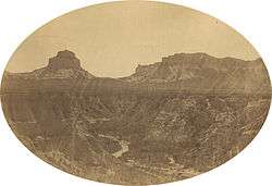 View through the pass, July 1858. By Samuel C. Mills, photographer with the Simpson Expedition.
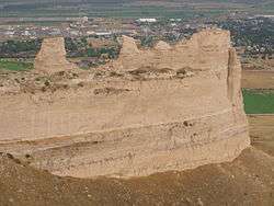 View from the summit
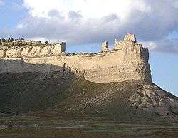 Saddle Rock in Scotts Bluff National Monument
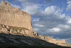 View northeastward from the summit of Mitchell Pass
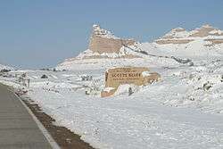 Scotts Bluff during winter (Nov. 2002)
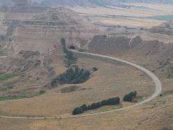 Tunnel Through Scotts Bluff
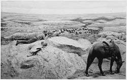 A buffalo hunter takes aim. From an exhibit at the Scotts Bluff National Monument.
Proper spelling
There has always been some disagreement as to the proper spelling of this geomorphic feature, specifically with regard to the apostrophe. For example, an 1843 map titled Map of an Exploratory Expedition to the Mountains in 1842 by John C. Frémont labeled the feature Scott's Bluff (with an apostrophe). Another early military map of Nebraska and the Dakotas published in 1875 by G.K. Warren dropped the apostrophe and labeled the feature simply as Scotts Bluff. There are numerous other examples in the late 19th and early 20th centuries in which the name has been spelled with or without an apostrophe. In a final decision by the United States Board on Geographical Names rendered on June 11, 1941, the name Scotts Bluff (without an apostrophe) was officially adopted.[7]
Trails
Summit Trails
The North Overlook Trail is a 0.5-mile (0.80 km) paved trail that leaves from the summit parking lot and overlooks the North Platte River Valley. Visitors can reach the highest point on the bluff at 4,659 feet (1,420 m) above sea level.
The South Overlook Trail is a 0.4-mile (0.64 km) paved trail that leaves from the summit parking lot towards the south. From the overlook, visitors can see the Visitor Center and Mitchell Pass.
Saddle Rock Trail begins at the Visitor Center and climbs 435 feet (133 m) in 1.6 miles (2.6 km). The first third of the trail is relatively level from the Visitor Center to Scott's Spring. From here, the trail climbs rapidly most of the 435 feet (133 m) in 0.8 miles (1.3 km). This trail has been closed due to damage from a rock slide since December 2015.
The Oregon Trail Pathway is a short trail ascending 85 feet (26 m) in 0.5 miles (0.80 km). The trail begins at the display of a Murphy and Conestoga wagons and ends in Mitchell Pass.
The Bike Path is the only trail available to users other than hikers. It runs from the Visitor Center to the eastern boundary of the park. It drops 50 feet (15 m) in 1.2 miles (1.9 km).[8]
National Monument
The Department of Interior designated Scotts Bluff and several nearby bluffs as a National Monument on December 12, 1919; they were placed for management under the National Park Service, created just three years prior.
The Oregon Trail Museum and Visitor Center was built at the base of the bluff which serves as a start for hiking tours of the bluffs. Exhibits focus on the westward expansion and pioneers, the drawings and paintings of William Henry Jackson, and the geology and paleontology of the region.
In the 1930s during the Great Depression, a roadway leading to the top of Scotts Bluff was constructed by the Civilian Conservation Corps, organized by President Franklin D. Roosevelt's administration. The road goes through three tunnels on its way to the top and provides easy access to the summit.
All historic sites administered by the National Park Service were listed on the National Register of Historic Places on October 15, 1966, when it was established.[9]
 Looking north-northwest at Scottsbluff National Monument, Gering, Nebraska
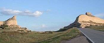 Mitchell Pass, looking eastward
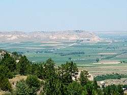
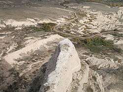 Looking down at road and irrigation ditch to the northeast from Scotts Bluff National Monument.
 Bicycle path can be seen on the right.
See also
References
- ↑ "Scotts Bluff National Monument". Geographic Names Information System. United States Geological Survey.
- ↑ "Listing of acreage as of December 31, 2011". Land Resource Division, National Park Service. Retrieved March 19, 2012.
- ↑ "NPS Annual Recreation Visits Report". National Park Service. Retrieved March 19, 2012.
- ↑ Fitzpatrick, Lillian L. (1960). Nebraska Place-Names. University of Nebraska Press. pp. 128–130. ISBN 0-8032-5060-6.
- ↑ "It Happened on the Oregon Trail," pg.6, by Tricia Martineau Wagner
- ↑ "The Twin Cities: Gering and Scottsbluff". Center for Advanced Land Management Information Technologies. University of Nebraska. Retrieved August 23, 2014.
- ↑ "Decision Card". United States Board on Geographical Names. June 11, 1941. Retrieved July 6, 2013.
- ↑ "Hiking Trails"; Scotts Bluff National Monument; National Park Service
- ↑ National Park Service (2009-03-13). "National Register Information System". National Register of Historic Places. National Park Service.
External links
![]() Media related to Scotts Bluff National Monument at Wikimedia Commons
Media related to Scotts Bluff National Monument at Wikimedia Commons
- Official website
- Historic American Engineering Record (HAER) No. NE-11, "Scotts Bluff Summit Road, Gering, Scotts Bluff County, NE"
- U.S. Geological Survey Geographic Names Information System: Scotts Bluff National Monument
Mormon Trail landmarks | ||
|---|---|---|
| Illinois | 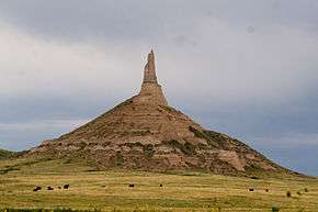 | |
| Nebraska | ||
| Wyoming | ||
| Utah | ||
| Topics | |
|---|---|
| Lists by states |
|
| Lists by insular areas | |
| Lists by associated states | |
| Other areas | |
| |