South Platte River
| South Platte River[1] | |
|---|---|
 South Platte River in Douglas County, Colorado, | |
 | |
| Basin | |
| Main source |
Confluence of South Fork and Middle Fork 39°00′40″N 105°44′25″W / 39.01111°N 105.74028°W[1]) |
| River mouth |
Confluence with North Platte River 2,762 ft (842 m) 41°06′50″N 100°40′33″W / 41.11389°N 100.67583°WCoordinates: 41°06′50″N 100°40′33″W / 41.11389°N 100.67583°W |
| Progression | Platte—Missouri—Mississippi |
| Physical characteristics | |
| Length | 439 mi (707 km)[2] |
| Discharge |
|
| Features | |
| Discharge range | 0 to 4,640 cu ft/s (0 to 131 m3/s)[3] |


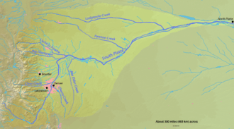
The South Platte River is one of the two principal tributaries of the Platte River and is itself a major river of the American Midwest and the American Southwest/Mountain West, located in the U.S. states of Colorado and Nebraska. Its drainage basin includes much of the eastern flank of the Rocky Mountains in Colorado; much of the populated region known as the Colorado Front Range and Eastern Plains; and a portion of southeastern Wyoming in the vicinity of the city of Cheyenne. It joins the North Platte River in western Nebraska to form the Platte, which then flows across Nebraska to the Missouri. The river serves as the principal source of water for eastern Colorado. In its valley along the foothills in Colorado, it has permitted agriculture in an area of the Colorado Piedmont and Great Plains that is otherwise arid.
Description
The river is formed in Park County, Colorado, southwest of Denver in the South Park grassland basin by the confluence of the South Fork and Middle Fork, approximately 15 miles (24 km) southeast of Fairplay. Both forks rise along the eastern flank of the Mosquito Range, on the western side of South Park, which is drained by the tributaries at the headwaters of the river. From South Park, it passes through 50 miles (80 km) of the Platte Canyon and its lower section, Waterton Canyon. Here, it is joined by the North Fork before emerging from the foothills southwest of the Denver suburb of Littleton. At Littleton, the river is impounded to form Chatfield Reservoir, a major source of drinking water for the Denver Metropolitan Area.
The river flows north through central Denver, which was founded along its banks at its confluence with Cherry Creek. The valley through Denver is highly industrialized, serving generally as the route for both the railroad lines, as well as Interstate 25. On the north side of Denver it is joined somewhat inconspicuously by Clear Creek, which descends from the mountains to the west in a canyon that was the cradle of the Pike's Peak Gold Rush. North of Denver it flows through the agricultural heartland of the Piedmont (a shale region that was formed through erosion by the ancestor of the river following the creation of the Rockies). It flows directly past the communities of Brighton and Fort Lupton, and is joined in succession by Saint Vrain Creek, the Little Thompson River, the Big Thompson River, and the Cache la Poudre River, which it receives just east of Greeley.
East of Greeley it turns eastward, flowing across the Colorado Eastern Plains, past Fort Morgan and Brush, where it turns northeastward. It continues past Sterling, and runs into Nebraska between Julesburg, Colorado and Big Springs, Nebraska. In Nebraska, it passes south of Ogallala and joins the North Platte River near the city of North Platte.
The South Platte River through Denver is on the U.S. EPA's list of impaired waterbodies for pathogen impairment, with E. coli as the representative pathogen species. Other water issues involve the appearance of the New Zealand Mud Snail and of the Zebra Mussel.
History
The South Platte was originally called the Rio Chato (see the report of the Humano and Bonillo Expedition). In 1702, it was named the Rio Jesus Maria by Captain Jose Lopez, the Tewa Irish scout and Captain of War of the New Mexico Indian Auxiliaries who was ordered by the Viceroy of New Spain to search the Tierra Incognita for a French incursion into New Mexico.[4] The South Platte River also served as a vital water source in Colorado. Long before the city of Denver was created many travelers came to the South Platte River to escape the arid Great Plains. These people could survive the heat but not without the vital water source that the South Platte River gave them. Buckets and wells sufficed as a water system for a while but eventually the Denver Water System was created.[5]
Dams
In an arid region of the United States, the South Platte is marked with several dams. The first notable water impoundment on the South Platte is Antero Reservoir. "Antero" is derived from the Spanish word "first," as it was the first dam on the South Platte River near the river's origin.
The next dam is Spinney Mountain Reservoir. At capacity Spinney Mountain covers 2,500 acres (10 km2). A bottom release dam, Spinney releases to the east of the inlet.
Two miles below Spinney Mountain Reservoir, the river enters Eleven Mile Reservoir, with a capacity of 97,000 acre feet (120,000,000 m3). The Eleven Mile Reservoir Dam drains into Eleven Mile Canyon, which runs through Forest Service land. Under the reservoir are three former Colorado towns, Howbert, Idlewild, and Freshwater Station, which were submerged to meet the water needs of Denver.[6]
From Eleven Mile Canyon, the South Platte runs northeast to Cheesman Reservoir, named for Denver water pioneer Walter S. Cheesman. At its completion in 1905, the dam was the world’s tallest, at 221 feet (67 m) above the streambed. The reservoir and related facilities were purchased in November 1918 by the Denver Water Board. Cheesman was the first reservoir of Denver's mountain storage facilities and has been designated a National Historic Civil Engineering Landmark. Cheesman Reservoir feeds Cheesman Canyon. Six miles below Cheesman Reservoir is the town of Deckers; there, the river bends north for approximately 17 miles (27 km) to the confluence with the North Fork of the South Platte.
In the late 1980s, a proposal was put forth for the Two Forks Dam, which would have created a reservoir flooding the entire section from the North Fork confluence to the town of Deckers. In 1990 the Environmental Protection Agency vetoed the permit, calling the project an "environmental catastrophe."
From the confluence, the river flows towards Denver and enters Strontia Springs Reservoir.
Below Strontia Springs the South Platte runs through Waterton Canyon before entering Chatfield Reservoir. Chatfield marks the seventh and final dam on the South Platte until it merges with the North Platte.
Fly fishing overview
The South Platte River is a Gold Medal Western trout river on the Eastern Slope of Colorado. The river is well known for its wild trophy population of Brown Trout and Rainbow Trout. As a result of the close proximity to Denver, the river sees thousands of fly fishing enthusiasts each year. With seven dams on the river, the South Platte is considered a tailwater fishery. Most of these dams are bottom released which allow for both stable water temperatures throughout the year, and year round fly fishing. Popular fly fishing stretches of the river include Waterton Canyon, Deckers, Cheesman Canyon and the Dream Stream.
Recreation
See also
References
- 1 2 "South Platte River". Geographic Names Information System. United States Geological Survey. Retrieved 2011-01-29.
- ↑ U.S. Geological Survey. National Hydrography Dataset high-resolution flowline data. The National Map, accessed March 25, 2011
- ↑ Water Data Report, Colorado 2003, from Water Resources Data Colorado Water Year 2003, USGS.
- ↑ Nebraska: A Guide to the Cornhusker State. Nebraska State Historical Society. p. 46.
- ↑ Denver Water History. Accessed June 23, 2014.
- ↑ Laura King Van Dusen, "Forty-Six Years in Howbert: 1887-1933: Former Ranching, Railroading Community Covered by Eleven-Mile Reservoir", Historic Tales from Park County: Parked in the Past (Charleston, South Carolina: The History Press, 2013), ISBN 978-1-62619-161-7, pp. 97-104.
External links
| Wikimedia Commons has media related to South Platte River. |
- Antero Reservoir
- Chatfield Reservoir
- Cheesman Reservoir
- USGS: South Platte River Basin
- University of Colorado: GIS Hydro Data for the South Platte
- City of Denver: South Platte Initiative
- Eleven Mile Reservoir
- The Greenway Foundation
- Spinney Mountain Reservoir
- Strontia Springs Reservoir and Waterton Canyon