Virginia City, Montana
| Virginia City, Montana | |
|---|---|
| Town | |
|
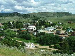
Virginia City from a nearby hillside | |
 Location of Virginia City, Montana | |
| Coordinates: 45°17′39″N 111°56′28″W / 45.29417°N 111.94111°WCoordinates: 45°17′39″N 111°56′28″W / 45.29417°N 111.94111°W | |
| Country | United States |
| State | Montana |
| County | Madison |
| Area[1] | |
| • Total | 0.95 sq mi (2.46 km2) |
| • Land | 0.95 sq mi (2.46 km2) |
| • Water | 0 sq mi (0 km2) |
| Elevation | 5,761 ft (1,756 m) |
| Population (2010)[2] | |
| • Total | 190 |
| • Estimate (2012[3]) | 196 |
| • Density | 200.0/sq mi (77.2/km2) |
| Time zone | Mountain (MST) (UTC-7) |
| • Summer (DST) | MDT (UTC-6) |
| ZIP code | 59755 |
| Area code(s) | 406 |
| FIPS code | 30-77125 |
| GNIS feature ID | 0778036 |
Virginia City is a town in and the county seat of Madison County, Montana, United States.[4] In 1961 the town and the surrounding area were designated a National Historic Landmark District, the Virginia City Historic District.[5] The population was 190 at the 2010 census.
History
Founding

In May 1863, a group of prospectors was headed toward the Yellowstone River and instead came upon a party of the Crow tribe and was forced to return to Bannack. On May 26, 1863, Bill Fairweather and Henry Edgar discovered gold near Alder Creek.[6] The prospectors could not keep the site a secret and were followed on their return to the gold bearing site. A mining district was set up in order to formulate rules about individual gold claims. On June 16, 1863 under the name of "Verina" the township was formed a mile south of the gold fields. The name was intended to honor Varina Howell Davis, the first and only First Lady of the Confederate States of America during the American Civil War. Verina, although in Union territory, was founded by men whose loyalties were thoroughly Confederate. Upon registration of the name, a Connecticut judge, G. G. Bissell, objected to their choice and recorded it as Virginia City.[7]
Within weeks Virginia City was a boomtown of thousands of prospectors and fortune seekers in the midst of a gold rush. The remote region of the Idaho Territory was without law enforcement or justice system with the exception of miners' courts. In late 1863, the great wealth in the region, lack of a justice system and the insecure means of travel gave rise to serious criminal activity, especially robbery and murder along the trails and roads of the region. Road agents as they became known were ultimately responsible for up to 100 deaths in the region in 1863 and 1864. This resulted in the formation of the Vigilance committee of Alder Gulch and the infamous Montana Vigilantes. Up to 15 road agents were hanged by the vigilantes in December 1863 and January 1864, including the sheriff of Bannack, Montana and alleged leader of the road agent gang, Henry Plummer.[8]
The Montana Territory was organized out of the existing Idaho Territory by Act of Congress and signed into law by President Abraham Lincoln on May 26, 1864.[9] Although Bannack was the first territorial capital, the territorial legislature moved the capital to Virginia City on February 7, 1865.[10] It remained the capital until April 19, 1875 when it moved to Helena, Montana.[11] Thomas Dimsdale began publication of Montana's first newspaper, the Montana Post, in Virginia City on August 27, 1864.[12] Montana's first public school was established in Virginia City in March 1866.[13]

Ghost town
In the 1940s, Charles and Sue Bovey began buying the town, putting much needed maintenance into failing structures. The ghost town of Virginia City began to be restored for tourism in the 1950s. Most of the city is now owned by the state government and is a National Historic Landmark operated as an open-air museum. Of the nearly three hundred structures in town, almost half were built prior to 1900. Buildings in their original condition with Old West period displays and information plaques stand next to thoroughly modern diners and other amenities.
The Historic District of Virginia City and Nevada City is currently operated by the Montana Historic Commission and is the top state-owned tourist attraction in Montana. The Commission operates gold panning, a historic hotel, and the longest continuously operating live summer theater company in the western United States.[15][16]
Virginia City also has a Boothill Cemetery.[17] There is also the 2 ft 6 in (762 mm) narrow gauge Alder Gulch Short Line Railroad, which transports passengers by rail to the nearby ghost town of Nevada City, Montana, and back.
Notable residents
- Sarah Bickford, African American businesswoman, owned a utility company.
- John Bozeman, prospector, merchant, founder of Bozeman, Montana and Bozeman Trail.
- Calamity Jane lived here for some time.
- Helen M. Duncan, geologist and paleontologist, grew up in Virginia City.
- Hezekiah L. Hosmer, first Chief Justice of Montana Territory Supreme Court, held court here.
- Nathaniel P. Langford, prospector, vigilante and first superintendent of Yellowstone National Park.
- Joseph Millard, later a United States Senator from Nebraska, lived and opened a bank here.
- Jack Slade, Pony Express co-founder and gunfighter, was lynched here.
- Nelson Story, prospector, merchant and cattleman, famous for 1866 cattle drive from Texas to Montana.
- Wilbur F. Sanders, founding member of the Vigilance Committee and United States Senator from Montana, lived here.[18]
- George Laird Shoup, Governor of Idaho, moved here after the Civil War.
- Sam V. Stewart, Governor and Supreme Court justice of Montana, practiced law here.
- Granville Stuart, prospector, vigilante, merchant, operated a store in Virginia City during the gold boom.
- William Boyce Thompson, founder of Newmont Mining, was born here.
Geography
Virginia City is located at 45°17′39″N 111°56′28″W / 45.29417°N 111.94111°W (45.294107, -111.941230).[19]
According to the United States Census Bureau, the town has a total area of 0.95 square miles (2.46 km2), all of it land.[1]
Climate
According to the Köppen Climate Classification system, Virginia City has a semi-arid climate, abbreviated "BSk" on climate maps.[20]
Demographics
| Historical population | |||
|---|---|---|---|
| Census | Pop. | %± | |
| 1880 | 624 | — | |
| 1890 | 675 | 8.2% | |
| 1900 | 568 | −15.9% | |
| 1910 | 467 | −17.8% | |
| 1920 | 342 | −26.8% | |
| 1930 | 242 | −29.2% | |
| 1940 | 380 | 57.0% | |
| 1950 | 323 | −15.0% | |
| 1960 | 194 | −39.9% | |
| 1970 | 149 | −23.2% | |
| 1980 | 192 | 28.9% | |
| 1990 | 142 | −26.0% | |
| 2000 | 130 | −8.5% | |
| 2010 | 190 | 46.2% | |
| Est. 2015 | 199 | [21] | 4.7% |
2010 census
As of the census[2] of 2010, there were 190 people, 102 households, and 55 families residing in the town. The population density was 200.0 inhabitants per square mile (77.2/km2). There were 171 housing units at an average density of 180.0 per square mile (69.5/km2). The racial makeup of the town was 91.6% White, 0.5% Asian, 0.5% from other races, and 7.4% from two or more races. Hispanic or Latino of any race were 1.6% of the population.
There were 102 households of which 17.6% had children under the age of 18 living with them, 40.2% were married couples living together, 9.8% had a female householder with no husband present, 3.9% had a male householder with no wife present, and 46.1% were non-families. 42.2% of all households were made up of individuals and 11.8% had someone living alone who was 65 years of age or older. The average household size was 1.86 and the average family size was 2.49.
The median age in the town was 51.3 years. 15.3% of residents were under the age of 18; 3.6% were between the ages of 18 and 24; 23.1% were from 25 to 44; 39.6% were from 45 to 64; and 18.4% were 65 years of age or older. The gender makeup of the town was 49.5% male and 50.5% female.
2000 census
As of the census[24] of 2000, there were 130 people, 72 households, and 32 families residing in the town. The population density was 140.4 people per square mile (54.0/km²). There were 122 housing units at an average density of 131.7 per square mile (50.7/km²). The racial makeup of the town was 94.62% White, 2.31% Native American, 0.77% from other races, and 2.31% from two or more races. Hispanic or Latino of any race were 0.77% of the population.
There were 72 households out of which 18.1% had children under the age of 18 living with them, 40.3% were married couples living together, 1.4% had a female householder with no husband present, and 54.2% were non-families. 47.2% of all households were made up of individuals and 15.3% had someone living alone who was 65 years of age or older. The average household size was 1.81 and the average family size was 2.52.
In the town the population was spread out with 14.6% under the age of 18, 0.8% from 18 to 24, 23.8% from 25 to 44, 46.9% from 45 to 64, and 13.8% who were 65 years of age or older. The median age was 48 years. For every 100 females there were 106.3 males. For every 100 females age 18 and over, there were 117.6 males.
The median income for a household in the town was $30,000, and the median income for a family was $46,250. Males had a median income of $37,500 versus $19,167 for females. The per capita income for the town was $19,182. There are 5.7% of the population living below the poverty line, including those under eighteens and over 64.
Notes
- 1 2 "US Gazetteer files 2010". United States Census Bureau. Retrieved 2012-12-18.
- 1 2 "American FactFinder". United States Census Bureau. Retrieved 2012-12-18.
- ↑ "Population Estimates". United States Census Bureau. Retrieved 2013-06-03.
- ↑ "Find a County". National Association of Counties. Retrieved 2011-06-07.
- ↑ "Virginia City Historic District". National Historic Landmark summary listing. National Park Service. Retrieved 2008-07-15.
- ↑ Malone, Michael P.; Roeder, Richard B.; Lang, William L. (1991). Montana-A History of Two Centuries. Seattle, WA: University of Washington Press. pp. 65–66. ISBN 0-295-97129-0.
- ↑ Dillion, Mark C. (2013). "The Rise and Dominance of the "Fourteen-Mile City" at Alder Gulch". Montana Vigilantes 1863-1870 Gold, Guns and Gallows. Logan, UT: Utah State University Press. pp. 8–20. ISBN 9780874219197.
- ↑ Dillon, Mark C. (2013). Montana Vigilantes 1863-1870 Gold, Guns and Gallows. Logan, UT: Utah State University Press. ISBN 9780874219197.
- ↑ "An Act to provide a temporary Government for the Territory of Montana" (PDF). Thirty-sixth United States Congress. May 26, 1864. Archived from the original (pdf) on January 12, 2007. Retrieved 2007-01-20.
- ↑ Smith, Jeffrey J. (2003). Montana Book of Days. Missoula, MT: Historic Montana Publishing. p. 40. ISBN 0966335562.
- ↑ Parry, Ellis Roberts (2001). Montana Dateline. Guilford, CT: Globe Pequot Press. p. 81. ISBN 156044956X.
- ↑ Parry, Ellis Roberts (2001). Montana Dateline. Guilford, CT: Globe Pequot Press. p. 186. ISBN 156044956X.
- ↑ Parry, Ellis Roberts (2001). Montana Dateline. Guilford, CT: Globe Pequot Press. p. 51. ISBN 156044956X.
- ↑ archiveswest.orbiscascade.org
- ↑ http://www.virginiacitymt.com/
- ↑ http://www.virginiacityplayers.com/
- ↑ Boothill Cemetery - Madison County, Montana
- ↑ Dillon, Mark C. (2013). "Formation of the Vigilance Committee". Montana Vigilantes 1863-1870 Gold, Guns and Gallows. Logan, UT: Utah State University Press. pp. 119–134. ISBN 9780874219197.
- ↑ "US Gazetteer files: 2010, 2000, and 1990". United States Census Bureau. 2011-02-12. Retrieved 2011-04-23.
- ↑ Climate Summary for Virginia City, Montana
- ↑ "Annual Estimates of the Resident Population for Incorporated Places: April 1, 2010 to July 1, 2015". Retrieved July 2, 2016.
- ↑ "Census of Population and Housing". Census.gov. Retrieved June 4, 2015.
- ↑ "Census & Economic Information Center". Retrieved July 3, 2015.
- ↑ "American FactFinder". United States Census Bureau. Retrieved 2008-01-31.
External links
| Wikimedia Commons has media related to Virginia City, Montana. |
- Virginia City Chamber of Commerce website
-
 "Virginia City, a city and the county seat of Madison co., Montana". The American Cyclopædia. 1879.
Municipalities and communities of Madison County, Montana, United States | ||
|---|---|---|
| Towns |  | |
| CDPs | ||
| Ghost towns |
| |
| Unincorporated communities | ||
| Footnotes | ‡This populated place also has portions in an adjacent county or counties | |
| Topics | |
|---|---|
| Lists by states |
|
| Lists by insular areas | |
| Lists by associated states | |
| Other areas | |
| |