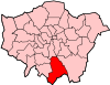
Coulsdon
| Coulsdon | |
 Brighton Road |
|
 Coulsdon |
|
| Population | 25,695 (2011 Census)[1] |
|---|---|
| OS grid reference | TQ3059 |
| London borough | Croydon |
| Ceremonial county | Greater London |
| Region | London |
| Country | England |
| Sovereign state | United Kingdom |
| Post town | COULSDON |
| Postcode district | CR5 |
| Dialling code | 020 |
| 01737 | |
| Police | Metropolitan |
| Fire | London |
| Ambulance | London |
| EU Parliament | London |
| UK Parliament | Croydon South |
| London Assembly | Croydon and Sutton |
Coordinates: 51°19′16″N 0°08′19″W / 51.3211°N 0.1386°W
Coulsdon (/ˈkuːlzdən/, traditionally pronounced /ˈkoʊlzdən/) is a town in south London, mainly within the London Borough of Croydon, with parts of Coulsdon also falling under the London Borough of Sutton and Reigate & Banstead. It is south of Croydon's historic boundaries at Purley and is approximately 13 miles (20.9 km) from Charing Cross.
History

The location forms part of the North Downs. The hills contain chalk and flint. Several dry valleys with natural underground drainage merge and connect to the relict headwater system of the River Wandle named 'River Bourne'.[2][3] Although the Bourne river floods periodically, the soil is generally dry and is the watershed which has constituted a natural route way across the Downs for early populations.
Fossil records exist from the Pleistocene period(4m years ago)[4]
There is evidence of human occupation from the Neolithic period, Iron Age,[5][6] Anglo-Saxon,[7][8][9][10] Bronze Age,[11][12] Roman and Medieval[13]
- 675. Frithwald, an Ealdorman and viceroy of King Wulfhere of Mercia gave land at Cuthraedesdune to Chertsey Abbey.[14][15][16] It appears as Colesdone in the Domesday Book.[17][18][19]
- 1537. The Dissolution of the monasteries passed ownership to the King.
The Taunton Manor, in the 1535 Valor Ecclesiasticus is recorded having an annual rent accruing to the House (Hospital) of St. Thomas of Acre from the Manor of "Tauntons" was 100ss and approximately 450 acres (180 ha) of wood belonged to it valued at a yearly rent of 12d. per acre.
In 1545 Henry VIII granted two homes with land in Whattingdon manor, Coulsdon: Welcombes and Lawrences to Sir John Gresham, the manor having been owned by Chertsey Abbey in the 8th century when it was recorded as Whatindone until the English Reformation in the 16th century.[20] The Whattingdon Manor was granted to Sir John Gresham, the manor having been owned by Chertsey Abbey in the 8th century when it was recorded as Whatindone until the English Reformation in the 16th century.[20]
- 1553 The Coulsdon Manor were granted or sold to various families, including Sir Nicholas Carew(1553) Sir Francis Carew(1557),[20] Jerome Weston, 2nd Earl of Portland, Sir Richard Mason, Sir Edward Darcy, Sir Robert Darcy, Sir Edward Bouverie (see Earl of Radnor).
- 1782 to 1921. Owned by three generations of the Byron family, who has already purchased the sub-manor of Hooley.[20][21][22]
- 1801 The Byron family moved to live at Hooley House.
- 1838. Byron sold a large amount of land to the 'London to Brighton railway company'. Byron moves from Hooley House to Portnall's Farm.
- 1850 Hartley Farm was demolished and Coulsdon Court was built by Thomas Byron. It was said to be constructed of the last bricks to be made locally at Crossways (at Coulsdon Road, Old Coulsdon).[23] In 1854, to avoid the Court, he adjusted the paths of some local roads, and created a gated drive from the public road.
- 1863 Edmund Byron inherited the title. After his use of the Enclosure acts were curtailed when he lost a case 1877 at the Court of Chancery,[24][25][26] large areas were sold in 1883 to the Corporation of London.[27][28][29][30] The importance of this event was reported in The Times.[31] He also sold and gave away various plots.[32]
- In 1921, Edmund Byron died. The remaining lands owned by the Byrons were sold. Land and manorial rights were passed to the Purley and Coulsdon Urban District Council.[33]
For many centuries, the lands contained several farms and manors and only on the coming of its branch railway were a few wealthy people from outside of the traditional borders attracted to build grand houses, by 19th century descriptions, such as:
This parish, which is situated on the road from London to Brighton, occupies an elevated position, and commands extensive and varied prospects.
Until 1921, the Byron family had largely maintained this tradition, despite sales of earlier land. The sales in the 1860s increased the number of landowners. Most housing in Smitham (Bottom/Valley) and the clustered settlement of Old Coulsdon, as well as the narrower valley between them, was built in the 80 years from 1890 to 1970. The area developed mixed suburban and in its centre urban housing:
The whole aspect of the parish has been completely transformed during the last twenty years by building. It was a little while ago entirely rural with a few new houses scattered along the line of the railway and up the valley towards Caterham, whence another deep depression in the chalk runs down to Smitham Bottom. Now there are continuous rows of villas and cottages and shops from Croydon to south of Coulsdon station.
The valley and routes in Smitham Bottom encouraged some early settlements. An Inn at the 'Red Lion' appears in the Bainbridge map of 1783. The coming of the railway and improved road links encouraged buildings along the sides of the major roadways and close to the stations. Since 1921. the sales of the old estate lands have replaced a countryside of discrete farms, with thousands of suburban dwellings.
Coulsdon segregated its long-haul from its short-haul traffic by gaining the Farthing Way A23 bypass, which opened in December 2006[35] as part of the Coulsdon Town Centre Improvement Scheme.
Economy
In the first two decades of the second millennium, Coulsdon's retail area lost Woolworth's and the bookstore on Brighton Road and opened The Pembroke[36] and Caffé Nero. Waitrose has a longstanding branch in the centre, and Tesco Express opened in the period mentioned. A planned Sainsbury's with apartments above has been singled out for note by periodical New London Architecture.[37] Aldi opened a branch in Coulsdon in 2015.
Coulsdon has few large company head offices but substantial storage and technology premises. One notable head office is that of Jane's Information Group.
Quarrying
The Hall family had been active in the Croydon area as coal and lime merchants since the 18th. In 1853 they leased an area of land in Coulsdon. In 1864 they close their quarries at Merstham and increased their quarrying for chalk and flints and use of Lime kilns in Coulsdon.[38][39]
This quarry at Coulsdon (Marlpit Lane) was named the 'Stoats Nest Quarry'. The works had its own internal railway system which connected to nearby main lines.
In 1898, Hall were refused permission (by their landlord) to build cement works on the Coulsdon site.[40]
The lime principally supplied for waterworks, gas works and tanneries. Demand reduced in 1902 when the Army changed from leather to webbing equipment. And in 1905 there was no longer demand from the gasworks.
Between 1905 and 1910 chalk was supplied for the Hall's cement works at Beddington.[41] In 1905, 13,000 tons of chalk were sent by rail from Coulsdon.[40] By 1918, it was processing lime for use as fertilizer.[42]
In 1920, the Hall company purchased 102 acres from their landlord, Byron. This offered their full benefit of the railways, kilns on the land.[43]
Halls maintained a trading depot in the Marlpit Lane quarry from 1923. It was named the "Ullswater trading estate". The limeworks closed in 1961.[38]
Place name
The town's spelling, pronunciation and location have changed. Coulsdon originally referred to the area now known as Old Coulsdon.
The name derives from Cuðrædsdun via Cullesdone pre-1130, Culesdone pre-1190, Cullisdon 1242, Culesdene 1255, Colendone c1270, Kulisdon 1279, Collesdon 1288, Cullesdon 1323, Colleston 1324, Coulesdon 1346, Cullysdon 1377, Colynsdon 1428, Colysdon 1439, Collysdon 1563, Cowlesdon 1557, Coulsdon 1597, Cowisden 1604, Couldisdon 1610, Couldesdon 1675, Culsdon 1678, Colsdon 1724.[44][45]
Additional variations include Curedesdone 675, Cudredesdone 675, Cudredesdune 967, Coulsdon 1083, Colesdone 1085, Culesdon 1234, Culisdon 1242, Cudredestreow 1251, Cullesdon 1266, Colesdene 1287, Colesdon 1290, Colesdun 1290, Culesdon 1291, Culesden 1292, Colieston 1324, Coulesden 1326, Coueleston 1332, Colisdon 1344, Culeston 1346, Cullysdon 1377, Cullisdoun 1403, Cullesdoun 1422, Culledon 1424, Colynsdon 1428, Collesdon 1439, Culsdon 1446, Cowlesdon 1539, Collesden 1544, Cowlesdowne 1553, Cullesdoy 1556, Colsdon 1558, Cowlesden 1558, Cullesden 1558, Cowllysdon 1567, Cowisden 1618, Coulsden 1619, Cowsdon 1620, Coolsden 1650, Coulesden 1650, Coilsoun 1655, Coulden 1655.[46][47]
The widely accepted origin of the name is ‘hill of a man called Cūthrǣd’, (from OE pers. name + dūn, a hill).[8] Alternatively the name originates from the Celtic or primitive Welsh "cull", meaning a leather bag, scrotum, bosom, womb or belly.[48][49][50]
The current town centre appears as Leydown Cross(1738)[51] or Leaden Cross(1800)[52][53] and Smitham Bottom.[54] In 1905, the parish council, and then the Post Office renamed "Smitham bottom" as "Coulsdon".[55][56] The name "Smitham Bottom" has also changed. Smetheden (1331), Smithdenbottom (1536), Smythedean(e)(1548), Smythden Bottom (1588), Smitham Bottom (1719)[54][57]
Localities
Coulsdon is a largely suburban district of London. The central area has substantial industrial, automotive and distribution services, convenience, standard socialising and niche retail as well as local professions of a typical town in the country, by its main road and main railway stations: Coulsdon South and Coulsdon Town. The alternate centre, Old Coulsdon, has a recreation ground/cricket pitch-focused village green, a much smaller parade of shops than Coulsdon's high street between Coulsdon South and Town stations and a medieval church. London's 'Brighton Road', locally the official name, and the railways, served by both semi-fast and stopping services, give Smitham Bottom/Valley a bustling, busier setting for economic life.
Old Coulsdon
Old Coulsdon occupies the south-east of the district.[58] Scattered, rather than clustered are six listed buildings, for their national heritage and architectural value, at Grade II. Two categories above this, in the highest class, Grade I is the Church of St John the Evangelist here. This is by the recreation ground, shortly after Marlpit Lane has been joined by Coulsdon Road, from the north. St John's is late thirteen century with extensive later additions, made of flint and rubble with much brick patching. Its nave spans two (window) bays. Older still is its "good" chancel of 1250 with stepped sedilia and piscina. The west tower above the entrance is of circa 1400 with corner buttresses and a tapering broach spire. A nave at right angles, replacing the south aisle; in decorated style was designed for its 1958 construction by J B S Comper.[59]
Smitham Bottom or Valley
At the heart of the geographical feature Smitham Bottom (where three dry valleys merge into one)[20] is this downtown part of the district. Most commerce and industry is here, set beside the Brighton Road, which is since 2006 a town centre arc of the A23 road and on Chipstead Valley Road which terminates half way along the arc, leading directly to Woodmansterne. The various local feeder roads reach this street, including the combined one from the south-east, Marlpit Lane, under the A23 without needing a junction with that trunk (long-distance) route (which later becomes the M23).
The soil is dry, and water was obtained even in 1912 by deep wells here in the chalk. This dry valley in the chalk, Smitham Bottom, has a watercourse below, the water of which in until the 16th century occasionally in times of flood ran here but after this, inexplicably, waits to break out as far as at the foot of the chalk in Croydon and Beddington, running through it.[20]
The Marlpit business and industrial estate
Marlpit (a former chalk quarry) is the town's Marlpit Industrial / Business Park estate, which is strong in storage, distribution and technology.
The Mount or Clockhouse
The Mount or Clockhouse is a square neighbourhood on a hill plateau with marked borders along three residential roads from Coulsdon, one of which continues from the town centre as the London Loop path, via the Banstead Downs and East Ewell to Nonsuch Palace 4 miles (6.4 km) north-west. It shares its local authority with that place as it is part of the London Borough of Sutton.[60]
Coulsdon Woods
This neighbourhood is a loosely defined residential part of Coulsdon, equally on undulating ground.
Cane Hill
This area forms the area of the former buildings and grounds of Cane Hill Hospital.
An approved development of the former site of Cane Hill Hospital by Barratt Developments may start in 2014, which if so, will create over six hundred new dwellings. In 2013, Barratt published a Public Consultation document[61] and report of feedback.[62] Resident's protests and concerns relate to the likely effect on local infrastructure, including access routes, the proposed mix of housing, transport and the provision of educational services.[63][64][65]
Open spaces
In 1883, to prevent further loss of Common lands arising from the Inclosure Acts, the Corporation of London (under provisions of the Corporation of London (Open Spaces) Act, 1878), purchased from Squire Byron (Lord of the Manor of Coulsdon) Farthing Downs, Coulsdon Common and Kenley Common, to add to the earlier purchase of Riddlesdown Common.[28][29] The London Borough of Croydon own and maintain several parks, including Happy Valley, which, together with Farthing Downs, is designated is a Site of Special Scientific Interest.[66]
Rickman Hill Park is the highest public park in London, at 155 metres above sea level.
A memorial park and recreation ground was purchased from the Byrons by Coulsdon & Purley Urban District Council and Hall & Co Ltd in 1920, it was opened in 1921.
The London Loop footpath passes through Happy Valley and Farthing Downs between Hamsey Green and Banstead. The Coulsdon section was the first of the 24 to be opened.
Grange Park was obtained partly by Public Subscription but mostly by the Urban District Council in 1929 from the owners of the Coulsdon Court Golf Course. The land was sold for use as an open space or pleasure and recreation ground. Grange Park was formerly part of Squire Byrons Coulsdon Court Estate. Grange Park is situated in a designated conservation area in the heart of Old Coulsdon and incorporates a children's play area and recreational green space. In total, Grange Park represents local green space of around 8 acres.
Friends of Grange Park, Old Coulsdon are fundraising to completely refurbish the old and run down children's play area. So far they have raised £38,000 to date and the cost of their project proposals which are now unveiled is £100,000. They must try to raise an ambitious £12,000 before December 2015, which will see them reach a milestone of 50% of their project costs and enable them to apply for the remaining project funds.
Places of religious interest

Places of worship include:
- St Mary and St Shenouda Coptic Orthodox Church.
- St Andrew's Anglican church. From 1914.
- St Aidan's Roman Catholic church[67] from 1964.[68]
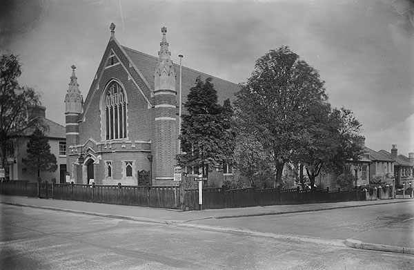
- The Brighton Road Methodist church. From 1911.[68][69]
- CCF, Coulsdon Christian Fellowship[70]
- Beit Hallel Messianic Synagogue[71]
- St John's Anglican church (Old Coulsdon)[72]
- St Mary's Roman Catholic church (Old Coulsdon)[73]
- Old Coulsdon Congregational Church[74][75]
- Kingdom Hall of Jehovah's Witnesses
Leisure
Athletics. The Old Coulsdon Hash House Harriers (or "OCH3") is a local hashing group.[76]
Gordon Pirie (1931–1991), an English long-distance runner lived in Coulsdon and was a member of South London Harriers, one of the oldest and most successful athletics club in Britain. The club has been based in Coulsdon since 1913, and remains there to this day. The club competes in cross-country, road running and track and field events, and trains from its Coulsdon HQ three times a week. The club has been heavily involved in recent years in building an eight lane all weather running track at Woodcote School. It also has an active and successful triathlon section.[77]
Bare-knuckle boxing fights were held at Smitham Bottom. Records exist of fights in 1788[78][79][80][81][82] and 1792.[83][84]
Bowls. Played at the Marlpit Lane Recreation Ground since the 1920s. A separate team played at the Ashdown Park Hotel.[85]
Cricket. Old Coulsdon had one of the first cricket clubs in the world, founded in 1762. It was one of the strongest teams in the country in the late 18th and early 19th century and once boasted eight England internationals, as well as a young Stuart Surridge. The club was possibly the first to use three stumps and two bails and frequently played matches on the most famous early cricket grounds such as Mitcham, and later in Grange Park in the village. In 1995 falling player numbers forced the club to merge with the nearby Redhill Cricket Club, playing at the Ring on Earlswood Common in the Earlswood neighbourhood of Redhill as Redhill & Old Coulsdon Cricket Club. Cricket was originally played at 'Smitham Bottom' opposite the Red Lion. The first archived results come from a games was played in 1731(Surrey vs East Grinstead). A 'Cricket Shed' appears in Smitham Bottom as a fixed building in a map of 1785.[88] In the 1880s, this area became was built over, and the club moved to Old Coulsdon. From the 1920s, cricket was played at The Memorial Gardens.
Cycling. Temperance Hotel.[89]
Football. Coulsdon United Football Club participate in the Combined Counties League Division One.
Golf. Played at Woodcote Park Golf Club(since 1920)[90] and at Coulsdon Manor.[91][92] Green bowls is available next door.[93] Ashdown Park Golf Club (now defunct) was founded in 1912. The club did not appear following WW1.[94]
Horse riding is available on the downs. Coulsdon has wide and long pavements and indoor cafés from which to watch any of the London-Brighton rallies (vintage cars, minis, Land Rovers, vintage commercial vehicles, motorbikes, cycling etc.).[95]
Hunting. Meetings of the 'Old Surrey Foxhounds' were held at the Red Lion from 1735 until 1908. In 1915, the hunt merged with Old Surrey Burstow and West Kent Hunt.
Rugby Union. Purley John Fisher Rugby Football Club[96] at Parsons Pightle, Old Coulsdon. Chipstead Rugby CLub[97] play locally at The Meads, Chipstead, offering mini, youth, adult social and adult league rugby.
Martial arts. The Coulsdon Martial Arts Club (also known as Yoshin Ryu) is long established and very popular with children and adults, founded and led by Errol Field, 12th dan Judo, 4th dan Karate, 6th dan Ju Jitsu. The club is well known for its annual cheese competition, giving away complimentary packets of Dairy Lea to local pensioners. It is on the site of what was originally a ‘tin’ church built by the Roman Catholic Church in 1916.[98]
Theatre. 'Theatre Workshop Coulsdon' branched from the Croydon Youth Theatre Organisation in 1970 and operates from the Youth & Social Centre.[99]
- Other
The Memorial Gardens has an adventure park, crazy golf, basketball, tennis, cricket and, in the summer, 'beach games' and events organised by the café.
Grange Park in Old Coulsdon has a playground, football pitches.[100] Rickman Hill Park hosts football, and has a children's playground, a zip wire, and tennis courts that were refurbished in 2009.
Demography
From 1889 until 1965 Coulsdon was in the administrative county of Surrey — between 1915 and 1965 the residents conferring additional local powers to Coulsdon and Purley Urban District. Under the London Government Act 1963 the London Borough of Croydon was formed.
The United Kingdom Census 2011 recorded that the two wards: Coulsdon East (ward) and Coulsdon West (ward), divided by the A23 road contained respectively: 12,244 people living in 4,912 homes and 13,449 living in 4,793 homes. The percentage of the population who declared their health as very good was 47% and 51% respectively.[1] White British was the majority ethnic group in both wards: 80% and 70% of the population respectively.[101][102]
Education
- Chipstead Valley Primary School
- Coulsdon Church of England Primary School
- Coulsdon Sixth Form College
- Keston Primary School
- The Lodge
- Oasis Academy Byron
- Oasis Academy Coulsdon[103]
- Smitham Primary School
- St. Aidan's R.C. Primary School
- Wattenden Primary School
- Woodcote High School
- Woodcote Primary School
Nearest places
Railway
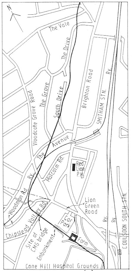
1804. The Surrey Iron Railway was enhanced by the "Coulsdon Merstham & Godstone Railway". These were horsedrawn railways which carried quarried materials and crops from Coulsdon and Merstham, and returned with fuel, metals and other materials.[104][105] To maintain a regular elevation at Coulsdon required large changes in direction and the construction of 20 ft embankments and a road bridge. Remnants of the 1805 railway embankment are still evident.[106][107] The railway closed in 1838 due to underuse.[108] A bridge over the Chipstead Valley road was demolished as dangerous in 1854.[109]
1841. The London & Brighton Railway line opened.[110]
1856. The Caterham railway opened. Initially intended to serve residents of Old Coulsdon, a station named 'Coulsdon' opened; later to be renamed 'Kenley'.
1893. Authorisation was given for a new (second) line to be built between Purley and Kingwood. This was the Chipstead Valley Railway which was later extended to become the Tattenham Corner line. Constructed by the South Eastern Railway in 1896, it opened in 1897 as a single-track line.
1900. The main line between Croydon and Coulsdon was widened. A new (third) line was opened added named the Quarry Line between Coulsdon North and Earlswood (bypassing Redhill). Constructed 1898–9. The line involved engineering work including cuttings, embankments and a covered way at Cane Hill Hospital.[111]
1923. Various station names changes, following amalgamations between various Railway companies.
Railway stations' names:
- Stoats Nest (1841-1856). Located over 500 yards to the north of the current stations. Closed December 1856. On the London-Brighton line.[112][113]
- Coulsdon South. Named 'Coulsdon' (1889), 'Coulsdon and Cane Hill' (1896), 'Coulsdon East' (1923), 'Coulsdon South' (1929). Located on the original London and Brighton Railway.[112]
- Coulsdon North. Named 'Stoats Nest and Cane Hill' (1899-1910) or simply 'Stoats Nest'[114] and replaced the earlier 'Stoats Nest Station', which was further north, 'Coulsdon and Smitham Downs' (1911), 'Coulsdon West' (1923), 'Coulsdon North' (later in 1923). The station closed in 1983. It was on the Quarry Line and included terminal platforms and sidings.[109]
- Coulsdon Town. Named 'Smitham' (1904), 'Coulsdon' (2010),[115] 'Coulsdon Town' (2011). On the Tattenham Corner line.[109][116]
- Reedham (Surrey). Named 'Reedham Halt' (1911), 'Reedham (Surrey)' (1980). On the Tattenham Corner line.
- Kenley. Named "Coulsdon" (1856), it was intended to serve the residents of Old Coulsdon. The station was shortly renamed as "Kenley". On the Caterham Line.
- Woodmansterne. Opened in 1932, meeting the demand from new housing in the area. On the Tattenham Corner line.[117]
References
- 1 2 "Check Browser Settings". statistics.gov.uk.
- ↑ Surrey County Council
- ↑ "London's Natural Signatures" (PDF). Natural England - Access to Evidence.
- ↑ Royal Holloway, University of London. Department of Geography. Title: Reconstructing a Palaeolithic Landscape. Dated 2011
- ↑ "- English Heritage". english-heritage.org.uk.
- ↑ Volume 9 of the Bourne Society's Local History Records (1970)
- ↑ Excavations in the Saxon Cemetery on Farthing Down, Coulsdon. John Wickham Flower
- 1 2 Surrey Archeological Society. Volume 6. Article "Notices of an Anglo-Saxon Cemetery at Farthing Down, Coulsdon, Surrey "
- ↑ Surrey Archeological Society. Volume 50. Article "Celtic Agriculture in Surrey by Brian Hope-Taylor"
- ↑ "Farthing Downs". The Megalithic Portal.
- ↑ Surrey Archeological Society. Volume 64. Article "hoard of late bronze age things at crooksbury hill, coulsdon."
- ↑ Surrey Archeological Society. Volume 38 . Article "shunaway plantation" 1928. bronze found.
- ↑ Croydon Council planning document
- ↑ Croydon Council report on parks and open spaces
- ↑ Tales from Chertsey Abbey by Lucy Wheeler
- ↑ Highways and Byways in Surrey, by Eric Parker. Date 1908.
- ↑ Chaldon Church Origins with Coulsdon parish at chaldonchurch.co.uk
- ↑ Surrey Domesday Book Archived 15 July 2007 at the Wayback Machine.
- ↑ http://www.domesdaymap.co.uk/place/TQ2959/coulsdon/ Coulsdon
- 1 2 3 4 5 6 7 H.E. Malden (editor). "Parishes: Coulsdon". A History of the County of Surrey: Volume 4. Institute of Historical Research. Retrieved 20 October 2013.
- ↑ "Parishes: Coulsdon". british-history.ac.uk.
- ↑ Hugh McCullough. "Coulsdon Lords of the Manor". oldcoulsdon.co.uk.
- ↑
- ↑ Croydon Natural History and Scientific Society ISSN 0309-6149
- ↑ The Story of English commons and forests. Commons Preservation Society. Lord Eversley
- ↑ Down with the Fences
- ↑ The Times (london, England), Monday, 21 May 1883; pg. 12; Issue 30825.
- 1 2 Riddledown History
- 1 2 The Corporation of London: Its origin, constitution, powers, and duties. City of London (England). Corporation Oxford University Press, 1950.
- ↑ Conservation report
- ↑ Report on the Dedication Of Coulsdon Commons. The Times (london, England), Monday, 21 May 1883; pg. 12
- ↑ Webmaster. "Plaque 24 - Smitham Bottom Infants School, Smitham". bournesociety.org.uk.
- ↑ Croydon Council. Local List of Historic Parks and Gardens December 2008
- ↑ Lewis, S. (1848). A Topographical Dictionary of England. London: Samuel Lewis, p.145.
- ↑ Transport for London Archived 17 August 2012 at the Wayback Machine.
- ↑ Kish Vaja, Stonegate Pub Company. "Party at the Pub". partyatthepub.co.uk.
- ↑ http://www.newlondonarchitecture.org/project.php?id=486&name=sainsburyscoulsdon
- 1 2 Surrey Gazette, 19 April 1864
- ↑ Auction, Lot number 15. Quarry 2006. Subterra Britannia Bibliographical Service
- 1 2 A century and a Quarter by C G Dobson. Published for private circulation by Hall and Co Ltd. 1951
- ↑ Effects of Mergers By Ruth Cohen, P. Lesley Cook. Page 127. References 'A Century and a Quarter' by C F Dobson, Hall and Co Ltd. 1951
- ↑ The Times, London, England, Monday, 1 July 1918; pg. 12
- ↑ The Times (london, England), Thursday, 1 July 1920; pg. 23
- ↑ The Bourne Society. Booklet "Bourne Society Records Volume 1".
- ↑ Appendix 4 to L B Croydon's Improving Coulsdon Centre
- ↑ 1905 book. by S.J Madge - Index to the Source Book of Materials for Local History.
- ↑ "The naming of Old Coulsdon". oldcoulsdon.co.uk.
- ↑ University of Nottingham - Institute of Name Studies School of English. "Key to English Place-names". nottingham.ac.uk.
- ↑ "Coulsdon Area History - PLACE NAME ORIGINS". spanglefish.com.
- ↑ Worcestershire Place Names by W H Duignan. Oxford university press. 1905. Page 45, reference to Coulsdon.
- ↑ Webmaster. "Bourne Society Maps, Plans and Sites of Interest". bournesociety.org.uk.
- ↑ Map of 1800
- ↑ [mapco.net/surrey1874/surrey28b.htm Map Of The County Of Surrey From Trigonometrical Survey With The Roads, Parks & Railways 1874.]
- 1 2 "Smitham - Hidden London". hidden-london.com.
- ↑ Pikle http://www.pikle.co.uk/londoncross/londoncross8.html
- ↑ "A short history of St Aidan's Parish". st-aidans-parish.org.uk.
- ↑ "The Historical Gazetteer of England's Place-names". placenames.org.uk.
- ↑ Grid square map Ordnance survey website
- ↑ Historic England. "Details from listed building database (1188464)". National Heritage List for England. St John the Evangelist - Grade I listing
- ↑ Grid square map Ordnance survey website
- ↑ http://www.canehillpark.co.uk/userfiles/canehill_boards/
- ↑ http://www.canehillpark.co.uk/userfiles/pdf/Cane%20Hill%20Feedback%20Report%20final.pdf
- ↑ "Fears Chipstead will be 'garrotted' by traffic from 650-home Cane Hill development in Coulsdon". Surrey Mirror.
- ↑ "Protestors warn Cane Hill development in Coulsdon will cause traffic chaos - Croydon Advertiser". Croydon Advertiser.
- ↑ "Coulsdon mini-town 'could leave kids without a local school'". Your Local Guardian.
- ↑ Natural England, Farthing Downs and Happy Valley citation
- ↑ "St Aidan's Catholic Parish, Coulsdon". st-aidans-parish.org.uk.
- 1 2 Village Histories - Coulsdon. The Bourne Society ISBN 0-900992-50-6
- ↑ Image. Surrey History Centre
- ↑ http://www.ccfworld.com
- ↑ "ページが見つかりませんでした - 錦糸町のデリヘルこぼれ話". ubmjc.org.
- ↑ "Old Coulsdon St John's Church". oldcoulsdon.co.uk.
- ↑ "Southwark Parish Directory". rcsouthwark.co.uk.
- ↑ Hugh McCullough. "Old Coulsdon Congregational Church". oldcoulsdon.co.uk.
- ↑ http://www.congregational.org.uk/content.aspx?id=3022
- ↑ "Old Coulsdon Hash House Harriers". och3.org.uk.
- ↑ "South London Harriers". southlondonharriers.org.
- ↑ "Kronos:". ejmas.com.
- ↑ Letters My Grandfather Wrote Me: Family Origins By Bryan Crawford 2011. ISBN 1456788531
- ↑ Jackson
- ↑ "British Museum - Image gallery: A representation of the famous battle at Smith in the Botton, near Croydon ... between John Jackson, & Thomas Futrell". British Museum.
- ↑ Sporting Magazine - Volume 12 - Page 78
- ↑ "British Museum - Image gallery: Dan beating the Phillistines". British Museum.
- ↑ "The Jewish Quarterly". jewishquarterly.org.
- ↑ "History - Old Coulsdon Bowling Club". oldcoulsdonbowlingclub.co.uk.
- ↑ Coulsdon and Purley Chess club http://www.ccfworld.com/Chess/ChessClubHome/C&P_History.htm
- ↑ "CCF Chess Home Page". ccfworld.com.
- ↑ Map 1785
- ↑ http://www.delaunecc.org/Century%20Awheel.pdf
- ↑ "Woodcote Village". woodcotepgc.com.
- ↑ http://www.ccgc.co.uk
- ↑ British Pathé. "The Lord Mayor Of London". britishpathe.com.
- ↑ Croydon Council
- ↑ "Ashdown Park Golf Club", "Golf’s Missing Links".
- ↑ "London to Brighton - Mini Run 2015". london-to-brighton.co.uk.
- ↑ "Purley John Fisher Rugby". pjfrfc.co.uk.
- ↑ "Chipstead Rugby". chipstead.co.uk.
- ↑ M. "Edith's Streets". edithsstreets.blogspot.co.uk.
- ↑ Theatre Workshop Coulsdon
- ↑ https://grangepark.squarespace.com/
- ↑ http://www.ukcensusdata.com/coulsdon-east-e05000150
- ↑ http://www.ukcensusdata.com/coulsdon-west-e05000151
- ↑ "Oasis Coulsdon". oasisacademycoulsdon.org.
- ↑ Wandle History
- ↑ Image showing the route through Coulsdon http://www.wandle.org/aboutus/mills/mcgowsir/images/13-21b.jpg
- ↑ Surrey Archeological Society. Volume 95. Article "The rise and fall of the Surrey Iron Railway, 1802-46."
- ↑ A painting by G.B.Wollaston (dated 1823) of the bridge crossing the Chipstead Valley Road
- ↑ "CHAPTER 7 THE EARLY AND MIDDLE YEARS OF THE SURREY IRON RAILWAY". wandle.org.
- 1 2 3 M. "Edith's Streets". edithsstreets.blogspot.co.uk.
- ↑ Cane Hill history
- ↑ Purley Residents
- 1 2 "CR5 Issue 97 June 2013". yudu.com.
- ↑ Good Stuff IT Services. "Stoats Nest Road". ABC Railway Guide.
- ↑ Map https://commons.wikimedia.org/wiki/File:LB_and_SCRly_map_204.jpg
- ↑ Webmaster. "Plaque 27 - Smitham Station". bournesociety.org.uk.
- ↑ "So Long, Smitham!". southernelectric.org.uk.
- ↑ M. "Edith's Streets". edithsstreets.blogspot.co.uk.
External links
| Wikimedia Commons has media related to Coulsdon. |
- Coulsdon West Residents' Association
- Friends of Grange Park, Old Coulsdon
- Coulsdon Community website
- History of the village of Coulsdon
- Coulsdon relief road scheme.
- The village of Old Coulsdon - well illustrated site.
- Caterham Sea Cadets on Coulsdon Road beside the Common
- Beit Hallel Messianic Synagogue
- Coulsdon United Football Club
- Coulsdon Martial Arts
| Section 5: | London Outer Orbital Path | Section 6: |
|---|---|---|
| Hamsey Green | Coulsdon | Banstead |