Riddlesdown Common
| Site of Special Scientific Interest | |
 | |
| Area of Search | Greater London |
|---|---|
| Grid reference | TQ330600 |
| Interest | Biological |
| Area | 32.0 hectares |
| Notification | 1988 |
| Location map | Magic Map |

Riddlesdown Common or Riddlesdown is a 43 hectare area of green space in Kenley, towards the northern end of the North Downs in the London Borough of Croydon. It is owned and maintained by the City of London Corporation, apart from two small areas, one of which is operated by the London Wildlife Trust[1][2] and the other by Croydon Council.[3] An area of 32 hectares is a biological Site of Special Scientific Interest.[4][5] The name Riddlesdown also applies to the local district of residential housing.
History
Discoveries of Neolithic stone axes and possible traces of Iron Age fields show that occupation goes back thousands of years. The name Riddlesdown is first recorded in 1331 as Ridelsdoune meaning 'cleared woodland on a hill'. In medieval time Riddlesdown and the neighbouring Kenley Common formed part of the waste land of the manor of Watendone, and the commoners rights included pasture for their livestock and gathering of materials for fuel. In the nineteenth century the coming of the railways increased the value of the land, and the lord of the manor, Edmund Byron, began enclosing the area. One local landowner, William Hall, refused to sell his land to Byron, and in 1877 Hall and his brother brought a case against Byron in the Court of Chancery for encroaching on Common Land. They were successful, William Hall then asked the Corporation of London to purchase the land to preserve it as open space. In 1883 the Corporation bought Riddlesdown and Kenley Common.[3][6] They became part of the City Commons, seven green spaces in south London managed by the City Corporation of London.[7]
Site of Special Scientific Interest
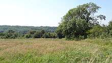
An area of 32 hectares is the Riddlesdown Site of Special Scientific Interest. It is the largest area of calcareous scrub in Greater London, with a herb-rich chalk grassland. It includes a disused chalk quarry which is not open to the public. It has many mature yew trees, Taxus baccata. It is one of the few places in London with juniper Juniperus communis. There are two nationally rare herbs, early gentian (Gentianella anglica) and round-headed rampion. Invertebrate species include the scarce Roesel's bush-cricket.[8]
Wider area
The site forms part of the Riddlesdown to Whyteleafe countryside area, which is managed by wardens working for the City of London, Croydon Council and Tandridge District Council.[6]
Access
There is access from Riddlesdown Road and Godstone Road.[9]
References
- ↑ "Riddlesdown Nature Reserve Management Brief" (PDF). London Wildlife Trust. 2012. Retrieved 23 August 2013.
- ↑ "Riddlesdown SSSI". London Wildlife Trust. Retrieved 23 August 2013.
- 1 2 London Gardens Online, Riddlesdown
- ↑ "Riddlesdown citation" (PDF). Sites of Special Scientific Interest. Natural England. Retrieved 21 January 2016.
- ↑ "Map of Riddlesdown". Sites of Special Scientific Interest. Natural England. Retrieved 21 January 2016.
- 1 2 London Borough of Croydon, Riddlesdown
- ↑ City of London, City Commons
- ↑ Natural England, Riddlesdown Unit 1
- ↑ City of London Corporation, Map of Riddlesdown Common
See also
- List of Sites of Special Scientific Interest in Greater London
- List of parks and open spaces managed by the City of London Corporation
- Croydon parks and open spaces
External links
- London Gardens Online, Riddlesdown
- London Borough of Croydon, Riddlesdown
- "Map of Riddlesdown SSSI". Natural England.
- Natural England, Riddlesdown SSSI citation
- Natural England, Riddlesdown Unit 1
- Natural England, Riddlesdown Unit 2
- Natural England, Riddlesdown Unit 3
- City of London Corporation, Riddlesdown
- City of London Corporation, Map of Riddlesdown Common
| Wikimedia Commons has media related to Riddlesdown Common. |
Coordinates: 51°19′25″N 0°05′34″W / 51.323562°N 0.092651°W