Erith
| Erith | |
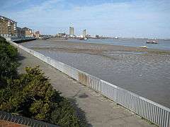 William Cory Promenade along the River Thames frontage and Riverside Gardens |
|
 Erith |
|
| Population | 68,662 |
|---|---|
| OS grid reference | TQ505775 |
| – Charing Cross | 13.3 mi (21.4 km) WNW |
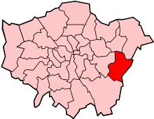
| London borough | Bexley |
| Ceremonial county | Greater London |
| Region | London |
| Country | England |
| Sovereign state | United Kingdom |
| Post town | ERITH |
| Postcode district | DA8 |
| Dialling code | 01322 |
| Police | Metropolitan |
| Fire | London |
| Ambulance | London |
| EU Parliament | London |
| UK Parliament | Erith and Thamesmead |
| Bexleyheath and Crayford | |
| London Assembly | Bexley and Bromley |
Coordinates: 51°28′48″N 0°10′40″E / 51.480°N 0.1778°E
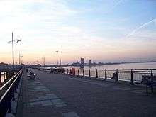
Erith (![]() i/ˈɪərᵻθ/) is a district of the London Borough of Bexley in south-east London, England, next to the River Thames, north-east of Bexleyheath and north-west of Dartford. Erith town centre has undergone modernisation and an increase in dwellings since 1961. The curved riverside high street contains three listed buildings, including the Church of England church and the Carnegie Building, while the district otherwise consists primarily of suburban homes. Erith is linked to central London and Kent by rail and a dual carriageway. It has the longest pier in London, and retains a coastal environment with salt marshes as well as industrial land.
i/ˈɪərᵻθ/) is a district of the London Borough of Bexley in south-east London, England, next to the River Thames, north-east of Bexleyheath and north-west of Dartford. Erith town centre has undergone modernisation and an increase in dwellings since 1961. The curved riverside high street contains three listed buildings, including the Church of England church and the Carnegie Building, while the district otherwise consists primarily of suburban homes. Erith is linked to central London and Kent by rail and a dual carriageway. It has the longest pier in London, and retains a coastal environment with salt marshes as well as industrial land.
Heritage

Pre-medieval
Work carried out at the former British Gypsum site in Church Manorway by the Museum of London Archaeological Service shows that the area was covered by a dense forest of oak, yew, and alder during the Neolithic Period, which by the Bronze Age had given way in part to sedge fen.[1]
The museum's work at the former site of Erith School in Belmont Road revealed traces of prehistoric settlement, and of a substantial community or farmstead in the first century AD.[2]
Anglo-Saxons
Following the collapse of Roman rule at the beginning of the 5th century, Britain was colonised by Anglo-Saxon invaders from northern Europe. The Anglo-Saxon Chronicle records that they won the Battle of Crecganford (thought to be modern Crayford) in 457 and shortly after claimed the whole of Kent. Their different way of life was reflected in their pattern of settlement. The town and country estates of the Roman bureaucrats gave way to a network of villages, occupied by warriors and farmers. Erith was one such village and has a Saxon name, originally Ærre hyðe meaning "old haven".[3]
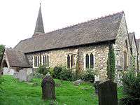
There was probably a church on the site of the present St John the Baptist's during the Anglo-Saxon period.[4] The early settlement was based around it, meaning that the centre of Erith was once west of its current location.
Medieval
The earliest reference to the area is in a Latin charter of 695 recording a grant by the Bishop of the East Saxons of certain lands at Erith. In early times, the area may also have been known as Lesnes or Lessness. After the Norman Conquest, Erith passed into the possession of Bishop Odo and is mentioned in the Domesday Survey. In 1315, a Royal Charter was granted for a market to be held in Erith every Thursday. However, it was noted in 1776 that the market had long been discontinued.[5]
Erith owes its existence to the Thames and was, until the 1850s, essentially a small riverside port, given prominence by King Henry VIII's decision to open a naval dockyard there, approximately where the Riverside Gardens are now. Henry's famous warship, Henri Grâce à Dieu, was fitted out there in 1515.[6] Up until the 19th century Erith remained a popular anchorage. Ships often discharged some cargo there to reduce their displacement before entering the shallows upstream.
Industrial era
In 1797 Edward Hasted described Erith as "consisting of one small street of houses, which leads to the water side," and mentions two annual fairs, at Ascension and Michaelmas.[7] In 1831 Erith's population was 1533 – it was described in 1840 as being "composed chiefly of two streets, one leading down to the water side, the other branching off to the left towards the church."[8]

By 1849 Erith was enjoying a short spell as a riverside resort. Its pier and nearby hotel gave hospitality for day-trippers arriving on Thames pleasure boats or by railway.[6]
The Local Government Act 1894 brought into existence Erith Urban District, which became the Municipal Borough of Erith in 1938. It included Northumberland Heath and Belvedere.
Erith Iron Works was established in 1864 in Anchor Bay by William Anderson.[9]
From 1881 Erith was home to a large cable works founded by William Callender. This became British Insulated Callender's Cables (BICC), and eventually Pirelli, which announced its partial closure in 2003. The remainder became Prysmian.
20th century
Engineering became an important industry around Erith, with armaments and cables being the main products. Vickers was a major employer and was linked to the Royal Arsenal at nearby Woolwich. Another local firm, Callender's Cables), supplied the world with high-class cable and laid a underwater pipeline across the English Channel, which supplied fuel to the Allied forces during the D-Day landings of 6 June 1944.[6]
A Grade II listed building in Walnut Tree Road was opened on 7 April 1906, to a design by a local architect, William Egerton, with financing from the Carnegie United Kingdom Trust. It was refurbished during 2000 but replaced by a more comfortable and accessible ground floor property better placed with respect to local shops in 2006. The Carnegie building also housed the Erith Museum, which is currently closed]].
The town was bombed heavily in the Second World War, mainly due its position on the riverside and near the Royal Arsenal. The bomb damage and a gradual decline in local trade prompted major redevelopment in the 1960s.[6]

In 1961, plans were put forward by local planners to redevelop Erith into a modern, sleek shopping and working environment. This involved clearing the sub-standard housing by the riverside and altering the street layout to accommodate more cars. Some of the buildings erected, particularly the social housing tower blocks, are of a brutalist form that typified the overspill estates put up by almost all councils in England's major cities as an affordable way of clearing the slums.[10]
In 1965, under the London Government Act 1963, Erith Municipal Borough was abolished and transferred to Greater London as part of the present London Borough of Bexley. The new boundary went far beyond the original London postal districts. However, for efficiency reasons, the Royal Mail decided not to expand the London postal district, so Erith, along with most of Bexley Borough, adjoins the SE postcode area but continues to be serviced from Dartford, Kent, and has DA postal codes.
Demolition of the old town started in 1966, when the Mayor of Bexley smashed Hedley Mitchell shop window, and continued in phases until 1980, leaving only a few reminders of the old town centre: Queens Church, The Cross Keys pub, the police station, the Carnegie Library, and Christ Church, whose rare murals make it the highest-ranked listed building in Erith (Grade II*). Many of the original Victorian buildings were lost, but some of the original townscape remains, including the White Hart in the High Street and St John's Church in West Street.[6]

Near the river promenade are two residential tower blocks completed in the early 1970s, the Playhouse (begun in 1973), and two shopping centres (1969 and 1973). Recently, these shopping centres have been refaced and extended to provide new social housing and better quality shops to complement the Morrison's supermarket to the east of town, making central Erith safer and more attractive. The site formerly used for outdoor markets became a car park serving the improved pedestrianised centre. In 1975–76, everything to the south of Pier Road was swept away for more modern housing and a straight dual carriageway, which forms an important divide and is directly alongside the railway.
During the First World War Erith was an important area for the manufacture of guns and ammunition, largely due to the presence of the large Vickers works in the Fraser Road area. In the Second World War, Erith found itself in the thick of the conflict, being directly on the German bombing routes from continental Europe to London, and also because of the nearby armament factories.[11]
For decades Erith has been the site of the Erith Oil Works, originally British Oil & Cake Mills (BOCM) and now owned by ADM, which processes various seeds into vegetable oils.

Regeneration
Since the late 1990s Erith has been undergoing significant changes, with the Erith Western Thames Gateway[12] project being the culmination.
The regeneration falls within the remit of the Thames Gateway project, with Erith as a key focus[13] for Bexley Council, as its only population centre on the River Thames.
Since 2000 a significant number of new flats have been constructed by the river by private companies. The Erith Western Gateway will include a significant number of new riverside flats,[14] and is expected to continue the regeneration of the area, hitherto a large underused area of the town centre. Bexley Council is seeking to produce a mixed-use development with a potential of 6,000 sq.m of new commercial space and over 500 new homes.[14] It has announced the selection of Crest Nicholson/Orbit South to take forward the Erith Western Gateway regeneration scheme. The timing and construction of the gateway is as yet uncertain.
Geography
Erith is a post town in the DA postcode area, consisting of the DA8 and DA18 postcode districts. DA8 covers Erith, Northumberland Heath and Slade Green; and DA18 covers Erith Marshes and Thamesmead. The nearest areas are Abbey Wood, Bexleyheath, Crayford, Dartford, Plumstead, Sidcup, Slade Green, Thamesmead and Woolwich.
 |
Belvedere | Coldharbour (across the River Thames) | Forty Hill | |
| Lessness Heath | |
Darent Industrial Park & Dartford Salt Marshes | ||
| ||||
| | ||||
| Northumberland Heath | North End | Slade Green |
Demography
62% of the population is White British, according to the 2011 census. The second largest ethnic is Black African, at 14%.[15]
Representation

A large part of Erith is in the Erith ward of the London Borough of Bexley. The local councillors are Joe Ferreira (Labour), Edward Boateng (Labour), and Abena Oppong-Asare (Labour).[16] The eastern part of Erith is in North End ward, and the southern part in Colyers ward.
Most of Erith lies within the Erith and Thamesmead constituency. The current Member of Parliament is Teresa Pearce (Labour). The eastern part of Erith is within the Bexleyheath and Crayford constituency, whose MP is David Evennett (Conservative).
Erith is in the Bexley and Bromley London Assembly constituency and is represented on the London Assembly by James Cleverly (Conservative).
Community interests are represented by Erith Town Forum. In the eastern part of Erith (in North End ward) community interests are also represented by Slade Green Community Forum.
Amenities
- For education in Erith see the main London Borough of Bexley article
In 1996, the two sites of Erith School, the East and West buildings, merged on one site on Avenue Road. In 2005, the school was awarded Specialist Schools status by the government, recognising its excellence in PE, Maths, and ICT. A new sixth-form block opened in 2007. Its Community Sports Centre is used during the evenings and weekends by a variety of teams.
A new swimming pool was recently built adjoining the sports centre and the David Ives Stadium,[17] which is home to Bexley Athletic Club and Erith Town F.C. ('The Dockers'), who play in the Kent League. (Note Erith & Belvedere F.C. play in Welling.) Erith Rugby Club play at Northumberland Heath Recreation Ground.
In 2007, the Tour de France passed through Erith during the London leg of the Tour.
The Erith Playhouse Theatre is the largest in Bexley.[18] There was a museum but it has now closed.[19] A new library with meeting room opened in Spring 2009 opposite the Health Centre.
The Erith Symphony Orchestra closed in 1972 and it was almost 30 years before another orchestra was heard in the town, when the Dartford-based, Orchestra of the Thames Gateway gave a concert there in 2004 and in subsequent years.
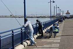
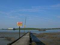
Erith is the location of the longest pier in London. The pier has recently been adapted from commercial to leisure use, and is popular with anglers. The annual Erith Riverside Festival has been held for a number of years in Riverside Gardens alongside the Thames. Erith Rowing Club is located in former police premises on the waterfront, accessed from Erith High Street. Downstream, Erith Yacht Club is very active in both competitive and social sailing, based on the edge of Crayford Marshes with a new clubhouse.
Erith is the starting point for the LOOP (London Outer Orbital Path) and one of the starting points for the Green Chain Walk.[20] The Thames Path National Trail,[21] which runs to the source of the River Thames at Kemble begins at nearby Crayford Ness.
The initial broadcasts of pirate radio station West and North Kent Radio (WNKR) took place at Norvic House, Larner Road, Erith, during the bank holiday weekend in August 1987, on a frequency of 91.8 FM. The station now transmits pre-recorded music shows on the medium wave (198 metres/1512 kHz) at weekends, with some internet streaming options offered since 2000.
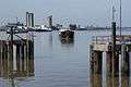 A ship at anchor on the Thames
 Erith Deep Wharf - the blue building is the sliding flood barrier necessary to be opened for access to the pier
 Erith Oil Works - the major crushers and refiners of rapeseed in the UK
Notable people
- Philip Absolon (1960-), Stuckist artist, was born in Erith
- Ronnie Aldrich (1916-93), jazz pianist and band-leader, was born in Erith[22]
- Patrick Young Alexander (1867-1943), aeronautical pioneer, born in Erith or Belvedere
- William Auld (1924-2006), Scottish poet, author and Esperantist, born in Erith[23]
- Sir William Anderson (1834-98), engineer and philanthropist, lived in Erith from 1864 until 1889 and contributed substantial time and money to the local community[24]
- Tony Brise (1952-75), motor racing driver, born in Erith[25]
- Wendy Cope (1945-), poet, born in Erith[26]
- John Downton (1906-1991), artist, poet and philosopher, born in Erith[27]
- Elaine Everest, historical novelist, born in Erith in 1953 and lived in the town until 1994. Her novels are set in the town with The Woolworths Girls (pan Macmillan) becoming a Sunday Times Bestseller.
- Kevin Horlock (1972-), footballer, Northern Ireland international, born in Erith[28]
- Bill Jaques (1888-1925), footballer, born in Erith[29]
- James Leasor (1923-2007), journalist and author[30]
- Dave Martin (1985-), footballer, born in Erith[31]
- Douglas McWhirter (1886-1966), amateur footballer, part of the gold-medal winning English team at the 1912 Summer Olympics, born in Erith[32]
- Percy Hilder Miles (1878–1922), professor, violinist and composer, was born in Erith[33]
- Alan Morton (1950-), footballer, born in Erith[34]
- Robert Napper (1966-), serial murderer and rapist, born in Erith[35]
- Anthony Reckenzaun (1850-93), the 19th century engineer, worked at the Erith Ironworks and set up evening classes for the workmen
- Steve Rutter (1968-), footballer, born in Erith
- Sam Saunders (1983-), footballer (Brentford F.C.), born in Erith[36]
- Linda Smith, comedian and writer, came from Erith.[37] Smith famously joked that Erith was not twinned with any town but did have a suicide pact with Dagenham.
- Jim Sterling (1984-), video game journalist, born and grew up in Erith[38]
- Denis Thatcher, husband of Prime Minister Margaret Thatcher, headed the family-owned Atlas Preservatives, based in Erith, until 1965[39][40]
- Henry Wheatley (1777-1852), keeper of the privy purse for King William IV and Queen Victoria from 1830 to 1846, born and grew up at Lesney House[41]
A rhyme by William Cosmo Monkhouse:
- "There are men in the village of Erith that nobody seeth or heareth,
- and there looms on the marge of the river a barge, that nobody roweth or steereth".[42]
Places of worship
- Barnehurst Methodist Church, Erith
- Christ Church, Victoria Rd. Erith
- Christadelphian Hall, Lesney Park Rd. Erith
- Northend Baptist Church, Larner Rd, Erith
- Northumberland Road Baptist Church, Belmont Road, Erith
- Our Lady of the Angels, Carlton Road, Erith
- Queen Street Baptist Church, Erith
- St. Augustines Church (Slade Green), Slade Green Rd, Erith
- St. Johns the Baptist Church, West Street, Erith
- St. Paul's Church, Mill Road, Erith
- The Treasure House, Bexley Road, Erith
Transport
Buses
Erith is served by London Buses routes 99, 229, 428, 469, B12 and N89.
Rail
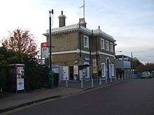
The nearest station is Erith for Southeastern services towards Barnehurst, Crayford, Dartford, Gillingham, Gravesend, London Cannon Street and London Charing Cross.
Road
The A2016 road bisecting Erith, is a dual carriageway stretching across the Erith Marshes.
References
- ↑ Museum of London summary of archaeological work carried out in 2001 accessed 6 April 2008
- ↑ Museum of London summary of archaeological work carried out in 1996 accessed 6 April 2008
- ↑ Hasted, Edward. "'Parishes: Erith', in The History and Topographical Survey of the County of Kent: Volume 2". British History Online. Canterbury. pp. 227–263. Retrieved 1 January 2016.
- ↑ Good Stuff IT Services (20 May 1953). "Parish Church of St John the Baptist - Bexley - Greater London - England". British Listed Buildings. Retrieved 2012-08-24.
- ↑ Bexley Local Studies Note 51 - Historical References to Erith Market accessed 6 June 2008
- 1 2 3 4 5 "History of Erith | History of Bexley and Districts". Ideal Homes. Retrieved 2012-08-24.
- ↑ 'The History and Topographical Survey of the County of Kent: Volume 2' (E.Hasted) Retrieved 6 March 2008.
- ↑ 'Pigots 1840', on website freepages.genealogy.rootsweb.com/~shebra/pigots_1840 Retrieved 5 December 2007.
- ↑ Bexley Local Studies Note 66 'Sir William Anderson' accessed 6 June 2008
- ↑ Urban regeneration: the essentials The Guardian
- ↑ Bexley Local Studies Note No. 11 - Erith accessed 6 June 2008
- ↑ Archived 7 October 2008 at the Wayback Machine.
- ↑ "London - Places - Why Thames Gateway is good for Bexley". BBC. 15 May 2008. Retrieved 2012-08-24.
- 1 2 "Erith Western Gateway". Retrieved 17 September 2007.
- ↑ http://www.ukcensusdata.com/erith-e05000075
- ↑ "Erith Councillors". London Borough of Bexley. Retrieved 2015-10-12.
- ↑ "Erith Stadium". Runtrackdir.com. 31 March 2005. Retrieved 2012-08-24.
- ↑ "Erith Playhouse". Playhouse.org.uk. 21 January 2012. Archived from the original on 29 July 2012. Retrieved 2012-08-24.
- ↑ "Managed on behalf of Bexley Council by the Erith Museum Group". Erith Museum. Retrieved 2012-08-24.
- ↑ "Explore South East London's Green Chain". Greenchain.com. Retrieved 2012-08-24.
- ↑ Ramblers. "Thames Path National Trail | Paths by name | Ramblers, Britain's Walking Charity". Ramblers.org.uk. Archived from the original on 28 September 2008. Retrieved 2012-08-24.
- ↑ "Surnames beginning with A". bexley.gov.uk. Retrieved 13 November 2016.
- ↑ "William Auld". The Scotsman. 15 September 2006. Retrieved 25 November 2016.
- ↑ "Sir William Anderson, 1834-1898". bexley.gov.uk. Retrieved 23 November 2016.
- ↑ "Tony Brise". historicracing.com. Retrieved 23 November 2016.
- ↑ Lewis, Helen (3 December 2011). "Wendy Cope interview: "I can't die until I've sorted out the filing cabinets"". The New Statesman. Retrieved 23 November 2016.
- ↑ "Awards entry catches the eye". Kent Online. 19 November 2012. Retrieved 23 November 2016.
- ↑ "Chatham Town unveil former Manchester City midfielder Kevin Horlock, 42, as their new manager". Kentish Football. 15 October 2015. Retrieved 25 November 2016.
- ↑ Joyce, Michael (2004). Football League Players' Records. soccerdata. p. 137. ISBN 1-899468-63-3.
- ↑ Adrian, Jack (22 December 2007). "James Leasor: Journalist and thriller writer". The Independent. Retrieved 23 November 2016.
- ↑ Hugman, Barry J., ed. (2009). The PFA Footballers' Who's Who 2009–10. Mainstream Publishing. ISBN 978-1-84596-474-0.
- ↑ "Douglas McWhirter bio, stats and results". sports-reference.com. Retrieved 25 November 2016.
- ↑ Musical Times through Google Books. 37. 1 February 1896. p. 98. Retrieved 7 February 2011.
- ↑ "Players: Alan Morton". The Historical Don. Retrieved 25 November 2016.
- ↑ Hughes, Mark (19 December 2008). "Rachel Nickell: Six mistakes in hunt for serial killer". The Independent. Retrieved 25 November 2016.
- ↑ Rollin, Glenda; Rollin, Jack, eds. (2012). Sky Sports Football Yearbook 2012–2013 (43rd ed.). London: Headline. p. 439. ISBN 978-0-7553-6356-8.
- ↑ "Linda Smith - Obituary". The Daily Telegraph. 1 March 2006. Retrieved 13 November 2016.
- ↑ Jim Sterling (11 April 2012). "Beautifully bleak, a quasi-defense of "dark and gritty" games". gamefront.com. Retrieved 23 November 2016.
- ↑ "Surnames beginning with T". bexley.gov.uk. Retrieved 23 November 2016.
- ↑ Christopher Winn: I Never Knew That about the Thames (London: Ebury Press, 2010).
- ↑ "The Wheatley's Housekeeper's accounts, 1792-1817". bexley.gov.uk. Retrieved 25 November 2016.
- ↑ Nonsense Rhymes, Cosmo Hamilton, R. Brimley Johnson, London, 1900
External links
| Wikimedia Commons has media related to Erith. |
- erithtown.net - an introduction and guide to Erith, with comprehensive directory
- Bexley Local Studies Note 11 - Erith - gives a good outline history of the area
- North West Kent Family History Society - Erith Parish Page
| Districts |
|  |
|---|---|---|
| Attractions |
| |
| Parks and open spaces |
| |
| Constituencies | ||
| Rail stations | ||
| Other topics | ||
| Section 1: | London Outer Orbital Path | Section 2: |
|---|---|---|
| START | Erith | Old Bexley |