Hornchurch
| Hornchurch | |
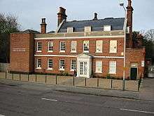
 Langtons House |
|
 Hornchurch |
|
| Population | 63,583 (2011)[1] |
|---|---|
| OS grid reference | TQ535865 |
| – Charing Cross | 15.2 mi (24.5 km) WSW |
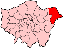
| London borough | Havering |
| Ceremonial county | Greater London |
| Region | London |
| Country | England |
| Sovereign state | United Kingdom |
| Post town | HORNCHURCH |
| Postcode district | RM11, RM12 |
| Dialling code | 01708 |
| Police | Metropolitan |
| Fire | London |
| Ambulance | London |
| EU Parliament | London |
| UK Parliament | Hornchurch and Upminster and Dagenham and Rainham |
| London Assembly | Havering and Redbridge |
Coordinates: 51°33′23″N 0°12′46″E / 51.5565°N 0.2128°E
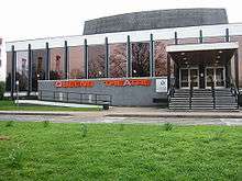
Hornchurch is a suburban town in the London Borough of Havering, East London, England, 15.2 miles (24.5 km) east-northeast of Charing Cross.[2] Historically an ancient parish in the county of Essex, that became the manor and liberty of Havering, Hornchurch shifted from agriculture to other industries with the growing significance of nearby Romford as a market town and centre of administration. As part of the suburban growth of London in the 20th century, Hornchurch significantly expanded and increased in population, becoming an urban district in 1926, and forming part of Greater London since 1965.[3] It is the location of Queen's Theatre, Havering Sixth Form College and Havering College of Further and Higher Education.
History
Toponomy
| 1881 | 2,824 |
|---|---|
| 1891 | 3,841 |
| 1901 | 6,402 |
| 1911 | 9,461 |
| 1921 | 10,891 |
| 1931 | 28,417 |
| 1941 | war # |
| 1951 | 79,908 |
| 1961 | 131,014 |
| # no census was held due to war | |
| source: UK census[4] | |
Hornchurch is an Anglicised version of the Latin Monasterium Cornutum, a term that was also applied to the mother Abbey in Savoy. The earliest recorded use here was in 1222, meaning "church with horn-like gables" and it was recorded as "Hornechurch" in 1233. The horned bull's head mounted on the eastern end of St Andrew's Church, near the town centre dates from much later, around the 18th century.
Origins
In the Anglian Ice Age, 450,000 years ago, the ice sheet reached The Dell, just south of St Andrew's Church in Hornchurch, the furthest south any ice sheet reached in Britain. Hornchurch Cutting is a Site of Special Scientific Interest just north of St Andrews Park which exhibits the geology.[5][6]
Stone Age tools, Bronze age and Iron age artefacts have been discovered in Hornchurch, indicating a lengthy occupation in pre-history. Roman remains, sufficient to indicate a settlement have also been found in South Hornchurch.[7] Hornchurch originates from around the 12th century when Henry II gave 1,500 acres (610 ha) to the hospice of St Nicholas and St Bernard, Mountjoux, in Savoy as a gift.[7] A prosperous Hornchurch Priory was established, near the parish church, but the monks were forced out during the 14th century when a new law banned foreign land ownership. The lands were then given to Lord Chancellor William of Wykeham who made major renovations to the church. He subsequently gave Hornchurch to endow New College, Oxford, which still owns all the local church lands and buildings. Due to this, Saint Andrew's Church was not adopted into the Diocese of Chelmsford until agreement was reached in the 1930s. The parish remains staffed by a vicar temporal and his curates.
Local government
Hornchurch, was a large ancient parish in the Becontree hundred of Essex; it was divided into the three chapelries of Havering-atte-Bower, Hornchurch and Romford. The Hornchurch chapelry stretched from the River Thames in the south to Harold Wood in the north and was located between the River Ingrebourne in the east and the River Beam in the west. It was also known as 'Hornchurch side' and consisted of the North End, South End and Town wards. Town ward was absorbed into North End and South End around 1722. Hornchurch chapelry occupied 6,783 acres (2,745 ha) of the 16,100-acre (6,500 ha) ancient parish.[8] The local authority was the Hornchurch vestry. The royal manor of Havering, which was conterminous with the ancient parish of Hornchurch, enjoyed special status and a charter in 1465 removed it from the Becontree hundred and the county of Essex to instead form an independent liberty. By the 16th century 'Romford side', comprising the five northern wards of Romford Town, Harold Wood, Collier Row, Noak Hill and Havering, had grown larger than Hornchurch and had achieved some degree of independence from the Hornchurch vestry. Havering ward grew independent in its own right and became a separate parish in the late 18th century.
Following the Poor Law Amendment Act 1834, Hornchurch and Romford became separate civil parishes in 1836 and were grouped into the Romford Poor Law Union. The area of the union, excluding the town of Romford, became a rural sanitary district in 1875. The special status of the Liberty of Havering was abolished in 1892 and the area was reincorporated into Essex. In 1894 the Hornchurch vestry was abolished, to be replaced by Hornchurch Parish Council. The rural sanitary district became Romford Rural District and the local authority became Romford Rural District Council. As the population of Hornchurch was rising, the parish council was abolished in 1926 and the parish was removed from the rural district. The parish of Hornchurch became Hornchurch Urban District and the local authority became Hornchurch Urban District Council. The council met at Langtons House from 1929. The urban district was significantly expanded in 1934 when the parishes of Cranham, Great Warley, North Ockendon, Rainham, Upminster and Wennington were added. The area formed part of the London Traffic Area from 1924 and the London Passenger Transport Area from 1933.[9] The whole area was included in the London Borough of Havering in 1965 and it was transferred from Essex to Greater London.
Modern history
During both the First World War and Second World War nearby Hornchurch Airfield was an important RAF station; it was known as RAF Suttons Farm during the Great War, with its HQ as far away as Upminster Hall. During the Second World War, the airfield was known as RAF Hornchurch, and was home mostly to a number of Spitfire squadrons, with an advanced sub-station at Rayleigh. The land has since been reused for a large housing development and Hornchurch Country Park. During the First World War a large vacant country estate called Grey Towers on Hornchurch Road was commandeered by the Army Council as a military depot. In January 1916 it became the first Command Depot for the New Zealand Contingent in Britain but was found to be more suitable as a Convalescent Hospital Camp for New Zealand Servicemen, and was run as such until June, 1919.[10] Like most suburbs of London, Hornchurch had been entirely rural until the arrival of the railway which spurred huge property development during the early 1900s. Whole estates were constructed such as Emerson Park to the north. Development was fuelled further by the arrival of the electrified District line during the 1930s with inter and post war housing developments south and west of Hornchurch in places such as Elm Park.
Governance

The town forms part of the Hornchurch and Upminster UK Parliament constituency. Elm Park and South Hornchurch are within the Dagenham and Rainham constituency. The local authority is Havering London Borough Council, with three councillors elected from each of a number of wards covering Hornchurch. The central part of town is within the St Andrew's ward and the area around Hornchurch tube station is within the Hacton ward. Western Hornchurch is within the Hylands ward, and there are also wards for Elm Park, Emerson Park and South Hornchurch. All of Hornchurch is within the Havering and Redbridge London Assembly constituency and the London European Parliament constituency.
Geography
The former Hornchurch civil parish was bounded with Upminster and Rainham by the River Ingrebourne to the east, with Dagenham by the River Beam to the west, with Romford to the north and by the River Thames to the south. It included the contemporary districts of Ardleigh Green, Elm Park, Emerson Park, Hornchurch town centre, Hornchurch Marshes and South Hornchurch; and parts of Gidea Park, Harold Wood and Upminster Bridge. Hornchurch is a post town in the RM postcode area, consisting of the RM11 and RM12 postcode districts. RM11 covers north of the high street including Ardleigh Green and Emerson Park, and RM12 covers south of the high street including Elm Park. The Hornchurch Marshes and South Hornchurch are within the Rainham post town and postcode district RM13.
Demography
Due to the status of Hornchurch as a "commuter town", it has a large population that commute to Central London each day to work. As a result, the town is above the UK average for GDP per capita, and has a large number of people with professional degrees living in the area.
Economy
Hornchurch is identified in the London Plan as a local district centre with 31,000 square metres (330,000 sq ft) of commercial floorspace.[2] It is not considered a significant commercial office location.[2] Within Havering, it is identified as one of seven town centres in the borough,[11] with a retail area extending along High Street, North Street and Station Lane.[12]
Transport
There are no stations in central Hornchurch, but four stations are located within the town; Upminster Bridge tube station is located just within its eastern boundary, Hornchurch tube station is located about 1⁄2 mi (800 m) south of the high street, Elm Park tube station is about 1 1⁄2 mi (2.4 km) to the south west and Emerson Park railway station is located about 1⁄2 mi (800 m) to the north. The nearest main line railway station is at Upminster.
Hornchurch is served by the following Transport for London contracted London Bus routes: 165, 193, 248, 252, 256, 365, 370 and 372.
Culture
Hornchurch Drum & Trumpet Corps Boys marching band formed in 1959 and perform all over the country. They were the first winners of the National British Marching Band Championships in 1976 and performed at the Edinburgh Tattoo in 1977.
The Towers Cinema on Hornchurch High Street opened in 1936. The Kemp & Tasker building, which was converted into a bingo hall in 1973, is noted for its Art Deco architecture. As of 2016 it is scheduled for demolition to make way for a supermarket.[13][14]
Hornchurch is served by Time 107.5 FM, located in Romford. The station covers Havering and surrounding areas. Bedrock[15] is the local hospital radio service available online to the Havering area and broadcasting a range of health-related information and locally produced entertainment.
Sport
A.F.C. Hornchurch is the local football team, formed to replace Hornchurch F.C. with Havering Hockey Club (formerly Hornchurch Hockey Club) accommodating the field hockey fixtures from their Harrow Lodge Park base. The Rom skatepark is located in the west of Hornchurch and is a Grade II listed structure.
In terms of top level sport, West Ham United are considered the local side due to the club's proximity to Hornchurch and the ease of reaching Upton Park on the District line. Dagenham and Redbridge are a more local team who were relegated from the Football League who also draw support from the town.
Music
The local music service is Havering Music School located on Winglety Lane. Hornchurch is also home to world-famous drum and bass record label RAM Records.
See also
References
- ↑ Wards of Elm Park, Emerson Park, Hacton, St Andrews and South Hornchurch www.ukcensusdata.com/havering-e09000016#sthash.9gQfqyyY.dpbs
- 1 2 3 Mayor of London (May 2006). "The London Plan: East London Sub Regional Development Framework" (PDF). Greater London Authority. Retrieved 2009-08-19.
- ↑ Young, K.; Garside, P., (1982). Metropolitan London: Politics and Urban Change 1837-1981.
- ↑ Great Britain Historical GIS / University of Portsmouth, Hornchurch population. Retrieved on 6 February 2010.
- ↑ "Geology Site Account, Hornchurch Railway Cutting". The Essex Field Club. Retrieved 2012-06-03.
- ↑ "Geology Site Account, The Dell". The Essex Field Club. Retrieved 2012-06-03.
- 1 2 Hornchurch: Introduction, A History of the County of Essex: Volume 7 (1978), pp. 25-31. accessed: 10 June 2008
- ↑ http://www.british-history.ac.uk/report.aspx?compid=42809
- ↑ Robson, William (1939). The Government and Mis-government of London. London: Allen & Unwin.
- ↑ Hornchurch: New Zealand Convalescent Hospital 1916-1919 Lost Hospitals of London. Retrieved 11 February 2014
- ↑ "Town centre management". Havering London Borough Council. 14 October 2008. Retrieved 9 February 2010.
- ↑ "Havering UDP: District Centres (schedule 7)". Havering London Borough Council. March 1993. Retrieved 9 February 2010.
- ↑ "Towers Cinema Hornchurch, Essex". Modernist Britain. Archived from the original on 12 October 2016. Retrieved 12 October 2016.
- ↑ Nagesh, Ashitha (30 August 2016). "Historic Art Deco cinema to be bulldozed to make way for new Lidl". Metro. Archived from the original on 31 August 2016. Retrieved 12 October 2016.
- ↑ "Bedrock (Hospital Radio)". Bedrock (Hospital Radio).
| Wikivoyage has a travel guide for Hornchurch. |
| Districts |
|  |
|---|---|---|
| Attractions | ||
| Major retail | ||
| Places of worship | ||
| Parks and open spaces | ||
| Constituencies | ||
| Tube and rail stations | ||
| Other topics | ||