Brentford
| Brentford | |
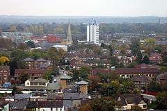 Skyline of Brentford town centre. The background comprises Kew Gardens in Kew, to which the town is linked by Kew Bridge, Richmond Park, Wimbledon Common and the North Downs. |
|
 Brentford |
|
| Area | 5.87 km2 (2.27 sq mi) |
|---|---|
| Population | 27,907 (Syon, Brentford wards 2011)[1] |
| – density | 4,754/km2 (12,310/sq mi) |
| OS grid reference | TQ1878 |
| – Charing Cross | 8 mi (12.9 km) WNW |
| Civil parish | n/a |
| London borough | Hounslow |
| Ceremonial county | Greater London |
| Region | London |
| Country | England |
| Sovereign state | United Kingdom |
| Post town | BRENTFORD |
| Postcode district | TW8 |
| Dialling code | 020 |
| Police | Metropolitan |
| Fire | London |
| Ambulance | London |
| EU Parliament | London |
| UK Parliament | Brentford & Isleworth |
| London Assembly | South West |
Coordinates: 51°29′10″N 0°18′36″W / 51.486°N 0.310°W
Brentford (/ˈbrɛntfəd/) is a town in west London, England, historic county town of Middlesex and part of the London Borough of Hounslow, at the confluence of the River Brent and the Thames, 8 miles (13 km) west-by-southwest of Charing Cross. It has formed part of Greater London since 1965.
Its economy has diverse company headquarters buildings which mark the start of the M4 corridor; in transport it also has two railway stations and the Boston Manor tube station on its north-west border with Hanwell. Brentford has a convenience shopping and dining venue grid of streets at its centre. Brentford at the start of its 21st century attracted regeneration of its little-used warehouse premises and docks including the re-modelling of the waterfront to provide more economically active shops, townhouses and apartments, some of which comprises Brentford Dock. A 19th and 20th centuries mixed social and private housing locality: New Brentford is contiguous with the Osterley neighbourhood of Isleworth and Syon Park and the Great West Road which has most of the largest business premises.
History
Toponymy

The name is recorded as Breguntford in 705 in an Anglo-Saxon charter and means 'ford over the River Brent'. The name of the river is Celtic and means 'holy one' and the '-ford' suffix is Old English.[2] The ford was most likely located where the main road crossed the river. New Brentford is recorded as Newe Braynford in 1521 and was previously known as Westbraynford. Old Brentford is recorded as Old Braynford in 1476 and was previously known as Estbraynford.[2]
Urban development
The settlement pre-dates the Roman occupation of Britain, and thus pre-dates the founding of London itself. Many pre-Roman artifacts have been excavated in and around the area in Brentford known as 'Old England'. Bronze Age pottery and burnt flints have been found in separate sites in Brentford. The quality and quantity of the artefacts suggests that Brentford was a meeting point for pre-Romanic tribes. One well known Iron Age piece from about 100 BC – AD 50 is the Brentford horn-cap[3] – a ceremonial chariot fitting that formed part of local antiquarian Thomas Layton's collection,[4] now held by the Museum of London. The Celtic knot pattern (the 'Brentford Knot') on this item has been copied for use on modern jewellery.

_1894854_78770255.jpg)

Brentford is the first point which was easily fordable by foot on the tidal portion of the River Thames (this was before dredging took place). Partly for this reason it has been suggested that Julius Cæsar crossed the Thames here during his invasion of Britain in 54 BC. In his own account, he writes that he crossed the river 80 miles (130 km) from the sea and Brentford is also this distance from his supposed landing beach. He further states that the river bank was protected by sharp stakes. During the building of Brentford Dock many such oak stakes were discovered. Dredging the river uncovered so many more that they had to be removed, for they were a hazard to navigation.[5] Although his descriptions are compelling, there is as yet, no archaeological proof that this was indeed the spot where he and his army had to fight to cross. It must also be kept in mind that Julius Cæsar's own accounts suffered in some part, to his embellishment of the facts. Nevertheless, outside the local County Courts there now stands the Brentford Monument, hewn from solid pink granite, whereupon it is asserted, that a documented battle took place here at this time between Cæsar's forces and Cassivellaunus.[6] There are, however, two other historically accredited battles of Brentford in 1016 and 1642.
Local fair
A local town fair, called the Brentford Festival, has been held in Brentford every September since 1900.[7][8]
Brentford Dock
The building of Brentford Dock was started in 1855[9] and it was formally opened in 1859. The dock yard is now a Marina and housing estate.[10]
The Hardwick family
A notable family from Brentford was the 18th/19th century architectural father and son partnership, the Hardwicks. Thomas Hardwick Senior (1725–1798) and Thomas Hardwick Junior (1752–1829) were both from Brentford and are buried in the old church of St Laurence. Hardwick Senior was the master mason for the Adam Brothers during the construction of Syon House. Hardwick Junior assisted in the building of Somerset House and was known for his designs of churches in the capital. He was also a tutor of J.M.W Turner whom he helped start Turner's illustrious career in art. Both father and son did a great deal of remodelling and rebuilding on the church of St Laurence.
Timeline
- 54 BC Brentford is a likely site of a battle recorded by Julius Cæsar between Julius Cæsar and the local king, Cassivellaunus.
- 781 Council of Brentford recording settlement of a dispute between King Offa of Mercia, and the Bishop of Worcester
- 1016 Battle of Brentford between the invading Canute and Edmund Ironside
- 1431 Relocation of Syon Abbey to Brentford from Twickenham
- 1539 Destruction of Syon Abbey by King Henry VIII
- 1616 – 1617 Pocahontas (birth name: Matoaka), Pamunkey princess, resided in Brentford with her husband, John Rolfe and son Thomas.
- 1642 Battle of Brentford during the English Civil War
- 1682 A very violent storm of rain, accompanied with thunder and lightning, caused a sudden flood, which did great damage to the town of Brentford. The whole place was overflown ; boats rowed up and down the streets, and several houses and other buildings were carried away by the force of the waters.[11]
- 1717 Brentford Turnpike Trust founded to maintain the road between Kensington and Hounslow
- 1805 Start of operations of the Grand Junction Canal (later the Grand Union Canal)
- 1815 – 1817 John Quincy Adams, sixth President of the USA, lived in Brentford.
- 1828 William Corder was arrested on Wednesday 23 April at Everley Grove House, Ealing Lane in Brentford, for the notorious Red Barn Murder.
- 1841 Brentford was flooded, caused by the Brent Reservoir becoming overfull so that the overflow cut a breach in the earth dam. Several lives lost.[12]
- 1849 Start of operations of the Hounslow Loop line, providing service to Kew Bridge, Brentford Central and Syon Lane stations in the Brentford area.
- 1859 Start of operations of the Great Western & Brentford Railway company linking Brentford Dock to the Great Western Railway main line at Southall. Additional passenger station named 'Brentford Town' later constructed just north of Brentford High Street.
- 1884 Start of operations of Boston Manor Underground station (then known as Boston Road).
- 1889 Brentford Football Club founded by a rowing club seeking a winter sport.
- 30 May 1925 – Great West Road officially opened by King George V. Later the Brentford section became known as the Golden Mile due to the large number of factories that relocated there to take advantage of the good communications. The factories provided high employment and stimulation to the local economy.
- 1 January 1929 – Grand Junction Canal bought by the Regent's Canal and amalgamated with other canals to form the Grand Union Canal.
- 1965 Opening of elevated section of M4 motorway
The road which is now Brentford High Street served as the main road to the South West of Britain for many centuries, and even now, the M4 motorway and the Great West Road pass approximately 1 mile (1.6 km) north of the original main road through Brentford.
Local government
Brentford developed around the ancient boundary between the parishes of Ealing and Hanwell. It was divided between the chapelry of Old Brentford to the east in Ealing and the chapelry of New Brentford in Hanwell to the west. Of the two areas, Old Brentford was significantly larger.
New Brentford was first described as the county town of Middlesex in 1789, on the basis that it was the location of elections of knights for the shire (or Members of Parliament) from 1701.[13][14] In 1795 New Brentford (as it was then) was "considered as the county-town; but there is no town-hall or other public building" causing confusion that remains to this day.[15]
The borough of Hounslow was formed in 1965, under the London Government Act 1963, by the merger of the area of the former Brentford and Chiswick Urban District, Feltham Urban District and the Heston and Isleworth Urban District (which held borough status as did Brentford and Chiswick) of Middlesex.
Geography
Nearest places:
 |
NW: Hanwell | Ealing | NE: Gunnersbury | |
| Osterley | |
Chiswick | ||
| ||||
| | ||||
| SW: Isleworth, Twickenham | Kew | SE: Strand-on-the-Green, Chiswick |
Demography and housing
| Ward | Detached | Semi-detached | Terraced | Flats and apartments | Caravans/temporary/mobile homes/houseboats | Shared between households[1] |
|---|---|---|---|---|---|---|
| Brentford | 150 | 826 | 1,425 | 3,511 | 17 | 25 |
| Syon (most homes in the ward are in New Brentford) | 147 | 806 | 1,488 | 3,299 | 33 | 17 |
| Ward | Population | Households | % Owned outright | % Owned with a loan | hectares[1] |
|---|---|---|---|---|---|
| Brentford | Brentford 14,353 | 5,954 | 15 | 23 | 315 |
| Syon | 13,554 | 5,790 | 16 | 28 | 272 |
Economy
- Allianz Cornhill Animal Health
- Best Foods, food importer and distributor
- Barratt Homes
- Brompton Bicycle (Headquarters), manufacturer of folding bicycles
- Carillion
- Datapoint (Headquarters)
- GlaxoSmithKline (Headquarters)[16]
- Global Blue (previously Global Refund) Global Blue
- EMC (London offices)
- E.M.Tool Designs (Ltd) (Headquarters)
- Heidelberg Graphic Equipment Ltd (subsidiary of Heidelberger Druckmaschinen AG)[17]
- JCDecaux UK[18]
- Kraft Foods International (European Union)
- Mapmechanics – GIS firm[19]
- Miniweb
- Sega Europe has its head office in Brentford[20]
- Sky
- Tie Rack Corporate Neckwear
- WorleyParsons (London offices)
- Brentford Lock West[21]
Landmarks
The Syon estate
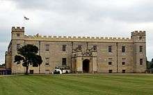
Syon House, the London residence of the Duke of Northumberland, is a large mansion and park in Syon ward, described above, that has long been shared with Isleworth. Some of its seasonally marshy land is now a public nature reserve. The estate has a hotel (Hilton London Syon Park), visitor centre and garden centre.
Syon Abbey, demolished and replaced (with reworked gatehouses) by the newer mansion, had the largest abbey church in England in the Middle Ages.
The location of Syon Abbey in the park was unknown until archeological investigations in the grounds in 2003 (for the television series Time Team) and 2004 revealed the foundations of the abbey church. It was larger than Westminster Abbey is now, but no above-ground structure remains. There were complex reasons for its destruction.
The London Butterfly House in Syon Park was an insectarium like a large glasshouse containing a butterfly zoo. Visitors could see butterflies and moths flying about, feeding, and emerging from chrysalises. There was also a colony of large ants (kept with the butterflies), a small tropical bird aviary, and a small gallery of reptiles, amphibians, insects and spiders. The lease on the current site expired in October 2007 and the Butterfly House closed on 28 October.
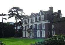
Boston Manor House, built in 1622, is a Jacobean manor house, noted for its fine plasterwork ceilings.
Syon Park House (demolished in 1953, and not to be confused with Syon House itself) housed the 'Syon Park Academy' where the poet Percy Bysshe Shelley was educated between the ages of 10 and 12 before moving on to Eton. A Royal Mail depot stands on the site now. This may also be the site of the dwelling where Pocahontas lived in Brentford End between 1616 and 1617.
Brentford Monument
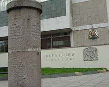
In 1909 a monument was made out of two stone pillars that used to support lamps on the old Brentford bridge over the Grand Union Canal. The monument originally stood at the end of Ferry Lane; after being covered in coal unloaded from boats, it was moved further up the lane in 1955. In 1992 it was moved again to its present site at the junction of Brentford High Street and Alexandra Road, outside the County Court. The monument commemorates four major events in Brentford's history: the supposed crossing of the Thames by Julius Caesar in 54 BC; the council of Brentford by King Offa of Mercia in 781; the defeat of King Canute by King Edmund Ironside at the first Battle of Brentford in 1016; and the second Battle of Brentford in 1642.[22]
Saint Paul's Church
Built in 1868 from Kentish ragstone, Saint Paul's Church is one of Brentford's two current Anglican parish churches, and a distinct landmark. Its spire is clearly visible. The architect was H. Francis. In 1959 and 1961 the parishes of the nearby churches of Saint George and Saint Lawrence were amalgamated with Saint Paul.[23]
Inside the church is a painting by local artist Johann Zoffany called Christ's Last Supper. It was originally intended to be installed in St Anne's Church, Kew, but the local people objected, and therefore in 1887 it was installed in Saint George's Church instead. When that church was closed in 1959, the painting was transferred to its present location in Saint Paul's Church.[24]
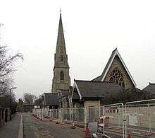
Saint Faith's Church
Brentford's other Anglican parish church, Saint Faith's, is a comparatively recent building, dating from 1906-7. Designed in Gothic Revival style, by G F Bodley and D G Hare, it was described by the poet John Betjeman:
St Faith’s displays all the splendour of Bodley in its simplicity and strength. It rises like a great ship over the housetops and inside the view from the west end leads you naturally to the altar and up to the roof.
Saint Lawrence's Church

There has been a church on the site of Brentford's former parish church of Saint Lawrence since the 12th century, but the tower dates from the 15th century, and the remainder of the church was rebuilt in 1764 from brick. There were a number of interesting monuments in the church, including one dedicated to a Maurice de Berkeley, dating from 1189, who was buried in the original church. The church was closed in 1961 and the monuments removed, and the parish was united with Saint Paul's.[26] The church has now been in a derelict state for more than half a century. A war memorial stood outside the church until 2009, when it was moved to Brentford Library.[27]
On the periphery
Gunnersbury Park Museum is in Gunnersbury House, narrowly in Gunnersbury (the north-west of Chiswick) containing artifacts and former furnishings of the Rothschild family, who were culturally and financially pre-eminent across France, Germany, the Netherlands, the United Kingdom and North America.
Kew Gardens is visible from the scattering of high rise buildings towering over the town and some of the mid rise ones.
The Weir bar, formerly 'The White Horse', was where the artist J. M. W. Turner lived for one year at the age of ten. He is regarded as having started his interest in painting while living there. Later he lived in Isleworth and Twickenham.

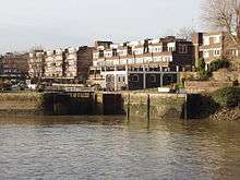
Brentford Dock
Brentford Dock came to single use and engineered enlargement as a freight terminus of the Great Western Railway. It was designed by Isambard Kingdom Brunel and built between 1855 and 1859 at the confluence of the River Thames and River Brent. A spur line from the GWR at Southall was constructed to the Brentford Dock railway station to facilitate easy transferral of freight from lighters and barges on the Thames to GWR-served destinations in the west of the country. The dock was redeveloped as residential accommodation from the early 1970s, and little industrial archeology remains. However, Dock Road still retains some of its original fan pattern cobblestone road bed and examples of Brunel's broad-gauge 'bridge section' rail can be seen there.
The Brentford Dock flats (originally named the Tiber Estate)[28] were built alongside formerly important transport infrastructure as Brentford is the terminus of the Grand Union Canal, originally the Grand Junction Canal. This waterway is still in use for leisure traffic as part of the Grand Union Canal.
Others
%2C_Brentford%2C_20050123.jpg)
Brentford Public Library is a Carnegie library, built by the architect Nowell Parr and opened in 1904. Outside the library is Brentford War Memorial, accompanied by three smaller war memorials.
Brentford Baths (1896), also by the architect Nowell Parr, is a Grade II listed example of late Victorian architecture.
The London Museum of Water & Steam houses the world's largest working beam engine, and its narrow cuboid tower is an emblem of the town.
The Musical Museum houses a large collection of mechanical musical instruments, such as player pianos and a Wurlitzer organ.

The Butts Estate, a Georgian square and associated conservation area, contains several Grade II listed buildings some dating back to 1680.[29]
Sports
Griffin Park is home to Brentford Football Club and Chelsea Football Club Reserves (from 2002 until 23 September 2005 it was the home of the London Broncos rugby league club – subsequently they were renamed Harlequins Rugby League and transferred to The Stoop).
Brentford F.C. is a professional English football club based in Brentford in the London Borough of Hounslow. It currently plays in the Football League Championship. It was founded in 1889 by members of the defunct Brentford Rowing Club and plays its home games at Griffin Park, its home stadium since 1904. The club has a long-standing rivalry with near neighbours, Fulham.[30]
Transport
Nearest tube stations:
- Northfields tube station
- Boston Manor tube station
- South Ealing tube station
- Gunnersbury tube station (Also a part of London Overground)
Nearest railway stations:
In popular culture
Brentford is referenced on several occasions in Aldous Huxley's 1932 novel Brave New World. Set in London of AD 2540 (632 A.F.—"After Ford"—in the book), this influential dystopia anticipates developments in reproductive technology, sleep-learning, psychological manipulation, and classical conditioning that combine to change society profoundly.
The BBC Three sitcom People Just Do Nothing is set in and around Brentford.
The Brentford Trilogy, a series of "far fetched fiction" novels by Robert Rankin, humorously chronicle the lives of a couple of drunken middle-aged layabouts, Jim Pooley and John Omally, who confront the forces of darkness in the environs of West London, usually with the assistance of large quantities of beer from their favourite public house, The Flying Swan.
See also
References
- Notes
- 1 2 3 Key Statistics; Quick Statistics: Population Density 2011 census Office for National Statistics
- 1 2 Mills, D. (2000). Oxford Dictionary of London Place Names. Oxford.
- ↑ http://www.museumoflondon.org.uk/archive/lbl/pages/moreObjResult.asp?id=4542&code=O1760&terms=horn+cap&search=&whichobj=&go=Go Archived 12 March 2007 at the Wayback Machine. museumoflondon.org.uk
- ↑ http://www.museumoflondon.org.uk/archive/lbl/pages/toursCollectors1.asp Archived 27 May 2011 at the Wayback Machine. museumoflondon.org.uk
- ↑ Sharpe, Montagu (1926). Some accounts of bygone Hanwell. Page 7,8,9, & 10. Brentford Printing and Publishing Coy., Ltd. London. UK.
- ↑ "The Thomas Layton Collection, Inscription on the Brentford Monument". Thomaslayton.org.uk. Retrieved 2014-06-03.
- ↑ "Brentford Festival 2010". Brentfordfestival.org.uk. Retrieved 2014-06-03.
- ↑ "Archived copy" (PDF). Archived from the original (PDF) on 16 March 2012. Retrieved 2011-07-06.
- ↑ "Archived copy". Archived from the original on 11 September 2011. Retrieved 2011-05-15.
- ↑ "Archived copy". Archived from the original on 6 January 2010. Retrieved 2011-05-15.
- ↑ Brentford, The Environs of London: volume 2: County of Middlesex (1795), pp. 39–58.. Date accessed: 18 August 2007.
- ↑ Defra:Foods and reservoir safety integration Vol 2: Appendix D pg 34. Accessed 2007-08-21
- ↑ 'Ealing and Brentford: Growth of Brentford', A History of the County of Middlesex: Volume 7: Acton, Chiswick, Ealing and Brentford, West Twyford, Willesden (1982), pp. 113–20 accessed: 30 May 2007
- ↑ Encyclopædia Britannica, 1911 Edition
- ↑ Brentford, The Environs of London: volume 2: County of Middlesex (1795), pp. 39–58 accessed: 30 May 2007
- ↑ "UK locations".
- ↑ "Heidelberg – Heidelberg UK". Uk.heidelberg.com. Retrieved 2014-06-03.
- ↑ "Contact Us." JCDecaux UK. Retrieved on 28 September 2011. "JCDecaux UK – Head Office 991 Great West Road Brentford, Middlesex"
- ↑ "Mapmechanics – Vehicle Routing & Scheduling – GIS Mapping Data – Territory & Field Force Planning". Mapmechanics.com. Retrieved 2014-06-03.
- ↑ "Corporate." SEGA. Retrieved on 31 January 2011. "SEGA Europe Ltd. 27 Great West Road Brentford Middlesex TW8 9BW United Kingdom."
- ↑ Brentford Lock West. "Our Story". www.brentfordlockwest.co.uk. Retrieved 10 April 2013.
- ↑ "Brentford Monument". BHS Project. Retrieved 2 August 2014.
- ↑ "Churches: Brentford". British History. Retrieved 2 February 2015.
- ↑ "Johann Zoffany". Brentford local website. Retrieved 2 February 2015.
- ↑ "Saint Faith's Church". Brentford History. 21 December 2013. Retrieved 2 February 2015.
- ↑ Weinreb, Ben, and Hibbert, Christopher (1992). The London Encyclopaedia (reprint ed.). Macmillan. p. 750.
- ↑ "West Brentford War Memorial Restoration". Brentford History Project. Retrieved 2 February 2015.
- ↑ "HISTORY OF THE DOCKS BRENTFORD". Retrieved 2008-01-07.
- ↑ "Brentford Dock Residents - Brentford and Brentford Dock history".
- ↑ "Guide". TalkFootball. Retrieved 2014-06-03.
- Bibliography
- The Archive Photographs Series, Brentford; Tempus Publishing Ltd., 1998, ISBN 0-7524-0627-2
- Brentford as it was; Hendon Publishing Co. Ltd., Second impression May 1993, ISBN 0-86067-082-1
- Brentford Past; Historical Publications Ltd., ISBN 0-948667-79-6
- Old Ordnance Survey Maps, Brentford 1894, The Godfrey Edition; Alan Godfrey Maps, ISBN 0-85054-509-9
Further reading
- Edward Walford (1883), "Brentford", Greater London, London: Cassell & Co., OCLC 3009761
External links
| Wikimedia Commons has media related to Brentford, London Borough of Hounslow. |
- Brentford, Chiswick & Isleworth Times online
- Fairly comprehensive amateur local history website on Brentford
- Brentford High Street project: people and properties 1840 – 1940
- The Brentford Biopsy
- Parish of Brentford - St Faith's and St Paul's
-
 Chisholm, Hugh, ed. (1911). "Brentford". Encyclopædia Britannica. 4 (11th ed.). Cambridge University Press.
| Districts |  | |
|---|---|---|
| Attractions | ||
| Parks and open spaces | ||
| Constituencies | ||
| Bridges | ||
| Tube and rail stations | ||
| Places of worship |
| |
| Other topics | ||