East London Line
| East London Line | |
|---|---|
|
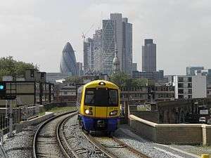
Class 378 train at Hoxton, with the City of London skyline in background | |
| Overview | |
| Type | Suburban rail, Rapid Transit |
| System | National Rail |
| Status | Operational[1] |
| Locale | Greater London |
| Termini |
Highbury & Islington Dalston Junction New Cross Clapham Junction Crystal Palace West Croydon |
| Stations | 23 |
| Services | 3 |
| Operation | |
| Opened |
27 April 2010 (preview service)[2] 23 May 2010 (full service)[3] |
| Owner |
Transport for London (TfL) Network Rail |
| Operator(s) | London Overground |
| Depot(s) | New Cross Gate |
| Rolling stock | Class 378 "Capitalstar" |
| Technical | |
| Number of tracks | Double track; sections with four tracks |
| Track gauge | 1,435 mm (4 ft 8 1⁄2 in) |
| Electrification | 750 V DC third rail |
The East London Line is part of the London Overground, running north to south through the East End, Docklands and South areas of London. It was previously a line of the London Underground.
Built in 1869 by the East London Railway Company, which reused the Thames Tunnel intended for horse-drawn carriages, the line became part of the London Underground network in 1933. After nearly 75 years as part of the Underground network, it closed in December 2007 for an extensive refurbishment and expansion, reopening as part of the Overground network in April 2010.[4][5][6] Phase 2, which links the line to the South London Line with a terminus at Clapham Junction, opened on 9 December 2012, creating an orbital railway around inner London.[7][8]
History
Establishment of the East London Railway
The East London Railway was created by the East London Railway Company, a consortium of six railway companies: the Great Eastern Railway (GER), the London, Brighton and South Coast Railway (LB&SCR), the London, Chatham and Dover Railway (LCDR), the South Eastern Railway (SER), the Metropolitan Railway, and the District Railway. The latter two operated what are now the Metropolitan, Circle, District and Hammersmith & City lines of the London Underground. The incorporation of the ELR took place on 26 May 1865 with the aim of providing a link between the LB&SCR, GER and SER lines.[9]
The companies reused the Thames Tunnel, built by Marc and Isambard Kingdom Brunel between 1825 and 1843 for horse-drawn carriages. The tunnel had generous headroom and two carriageways separated by arches, despite being only used by pedestrians. It connected Wapping on the north bank of the Thames with Rotherhithe on the south bank. A triumph of civil engineering, it was a commercial failure and by the 1860s it had become an unpleasant and disreputable place.[10]
The tunnel was the most easterly land connection between the north and south banks of the Thames, close to the docks on both banks of the river and was not far from mainline railways at either end. Converting the tunnel to a railway thus offered an ideal means of providing a cross-Thames rail link without having to go to the expense of boring a new tunnel. On 25 September 1865 the East London Railway Company took ownership of the tunnel at a cost of £800,000.[11] Over the next four years the company built a railway through the tunnel to connect with existing railway lines. The company's engineer was Sir John Hawkshaw, who was also responsible for the major re-design and completion of I K Brunel's long-abandoned Clifton Suspension Bridge at Bristol.[12]
The line opened in stages as financing became available:
- 7 December 1869: New Cross Gate (then New Cross) to Wapping opened, operated by the London, Brighton & South Coast Railway (LB&SCR), with intermediate stations at Deptford Road (now Surrey Quays) and Rotherhithe.
- 13 March 1871: A spur opened from just south of what is now Surrey Quays station to the South London Line's Old Kent Road station. Passenger services were withdrawn from 1 June 1911 and freight last used the line in 1964; the track was subsequently removed. This alignment was relaid and restored to passenger service by London Overground in late 2012 (see below).
- 10 April 1876: Wapping to Shoreditch, through a cut-and-cover tunnel constructed in part along the bottom of an infilled dock. At Shoreditch a connection was made with the Great Eastern Railway to Liverpool Street. Intermediate stations were at Shadwell and Whitechapel.
- 1 April 1880: A spur to New Cross (South Eastern Railway) opened.
- 3 March 1884: A spur to the Metropolitan and Metropolitan District Railways opened south of Whitechapel using St Mary's Curve. This enabled Metropolitan Railway and Metropolitan District Railway (District) trains to commence through services to the East London Railway later that year. Although passenger services via this spur ceased in 1941, it was retained to transfer empty trains to the rest of the sub-surface network.
Early utilisation
The East London Railway Company owned the infrastructure but it was operated by its controlling railways. Steam trains were initially operated by the GER, LB&SCR and the SER. The LB&SCR used its LBSCR A1 Class Terrier locomotives, which William Stroudley designed partly with this line in mind. It carried both passenger and goods trains; the LB&SCR operated between Liverpool Street and Croydon, the SER running between Addiscombe and Liverpool Street from April 1880 until March 1884. From March to September 1884 the SER service ran from Addiscombe to St Mary's (MR & MDR Joint Station). Metropolitan Railway services from St Mary's to New Cross (SER) and Metropolitan District Railway services from St Mary's to New Cross Gate (LB&SCR) commenced on 1 October 1884.[13] On 6 October through services started from Hammersmith (Hammersmith & City) to New Cross (SER) and from Hammersmith (MDR) to New Cross (LB&SCR).
Before the development of the Kent coalfields in the early part of the 20th century, house coal from the north for distribution in south London and as far afield as Maidstone and Brighton was an important source of revenue. Access at the north end of the line was difficult: trains were limited to 26 wagons and had to be shunted into the Great Eastern's Liverpool Street station and drawn forward onto the ELR. From October 1900 additional capacity was offered by a wagon lift, carrying two ten-ton wagons, from the Great Eastern coal depot at Spitalfields to a siding on the ELR near Whitechapel. The surface junction was taken up in 1966 and the lift closed in 1967, after a fire at the Spitalfields depot.[14][15]
When the Metropolitan District Railway was electrified in 1905 it ceased using the ELR, the last trains running on 31 July 1905;[13] the Metropolitan Railway suspended its service after 2 December 1906.[13] LB&SCR and GER services continued, and SER services recommenced on 3 December 1906.
The line was electrified, with the controlling railways funding the upgrade and the Metropolitan Railway providing the rolling stock. Electric services began on 31 March 1913 and ran from the two southern termini to Shoreditch and South Kensington via Edgware Road and High Street Kensington. In 1914 the service to South Kensington was diverted to Hammersmith, on what is now the Hammersmith & City line.
After the 1923 grouping the goods service was operated by London and North Eastern Railway (as successors to the GER), with the Metropolitan Railway continuing to provide passenger services.
The London Underground era
| East London line | |||||||||||||||||||||
|---|---|---|---|---|---|---|---|---|---|---|---|---|---|---|---|---|---|---|---|---|---|
| Overview | |||||||||||||||||||||
| Type | Sub-surface | ||||||||||||||||||||
| System | London Underground | ||||||||||||||||||||
| Stations | 9 (1 station closed) | ||||||||||||||||||||
| Ridership | 10,702,000[5] passenger journeys | ||||||||||||||||||||
| Colour on map | Dark orange | ||||||||||||||||||||
| Website | tfl.gov.uk | ||||||||||||||||||||
| Operation | |||||||||||||||||||||
| Opened | 1869 | ||||||||||||||||||||
| Closed | 2007 | ||||||||||||||||||||
| Owner | Transport for London | ||||||||||||||||||||
| Depot(s) |
New Cross Neasden | ||||||||||||||||||||
| Rolling stock | A Stock | ||||||||||||||||||||
| Technical | |||||||||||||||||||||
| Line length | 4.6 mi (7.4 km) | ||||||||||||||||||||
| |||||||||||||||||||||
| East London line | ||||||||||||||||||||||||||||||||||||||||||||||||||||||||||||||||||||||||||||||||||||||||||||||||||||||||||||||||||||||||||||||||||||||||||||||||||||||||||||||||||||||||||||||||||
|---|---|---|---|---|---|---|---|---|---|---|---|---|---|---|---|---|---|---|---|---|---|---|---|---|---|---|---|---|---|---|---|---|---|---|---|---|---|---|---|---|---|---|---|---|---|---|---|---|---|---|---|---|---|---|---|---|---|---|---|---|---|---|---|---|---|---|---|---|---|---|---|---|---|---|---|---|---|---|---|---|---|---|---|---|---|---|---|---|---|---|---|---|---|---|---|---|---|---|---|---|---|---|---|---|---|---|---|---|---|---|---|---|---|---|---|---|---|---|---|---|---|---|---|---|---|---|---|---|---|---|---|---|---|---|---|---|---|---|---|---|---|---|---|---|---|---|---|---|---|---|---|---|---|---|---|---|---|---|---|---|---|---|---|---|---|---|---|---|---|---|---|---|---|---|---|---|---|---|
Legend | ||||||||||||||||||||||||||||||||||||||||||||||||||||||||||||||||||||||||||||||||||||||||||||||||||||||||||||||||||||||||||||||||||||||||||||||||||||||||||||||||||||||||||||||||||
| ||||||||||||||||||||||||||||||||||||||||||||||||||||||||||||||||||||||||||||||||||||||||||||||||||||||||||||||||||||||||||||||||||||||||||||||||||||||||||||||||||||||||||||||||||
In 1933, the East London Railway came under the control of the London Passenger Transport Board. Although the infrastructure was still privately owned, passenger services were operated as the "East London Branch" of the Metropolitan line. In 1948 the railways were nationalised and became part of the British Transport Commission along with the Underground. Goods services continued to use the line until 1962, occasional passenger trains from Liverpool Street until 1966. The short length of track connecting Shoreditch to Liverpool St was removed in 1966. The service to Shoreditch was reduced, with Whitechapel becoming the northern terminus for much of the time; by the time Shoreditch station closed in 2006, it was only open at peak times on weekdays and most of Sundays (for Brick Lane Market).
Services to and from further west were curtailed during the early part of the Underground era. The service to Hammersmith was reduced to peak hours only in 1936 and withdrawn in 1941, leaving the East London branch as an isolated line. Its only passenger interchange to the Underground was at Whitechapel, with interchanges to main line trains at the two New Cross stations. In the 1980s and 1990s, the line gained two important new connections: Shadwell became an interchange with the Docklands Light Railway in 1987, and a station was added at Canada Water in 1999 for interchange with the Jubilee line.
The identity of the East London Line changed considerably during the London Underground era. On Tube maps between 1933 and 1968 it was depicted in the same colour as the Metropolitan line.[16] In 1970, it was renamed the "Metropolitan line — East London Section", in Metropolitan line purple with a white stripe down the middle. In the 1980s it became a line in its own right (though it was still grouped operationally with the Metropolitan line) and from 1990 the colour on the map changed to orange.
Maintenance passed to the Metronet consortium in 2003 under a public-private partnership, although the operation of trains continued to be the responsibility of Transport for London (TfL).
According to TfL, the line carried 10.7 million passengers per year before its temporary closure in 2007.[5]
Physical characteristics
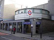
The line was the only Underground line not to penetrate Travelcard Zone 1. It was the second shortest line (after the Waterloo & City line), with an end-to-end journey time of 14 minutes. Its length was 5.6 miles (9.0 km), with nine stations. It ran in tunnel from Whitechapel to Surrey Quays, with the remainder on the surface or in cutting. Much of the line was built as cut-and-cover. The deepest point is at Wapping station, constructed in the Thames Tunnel's original entrance shaft 60 feet (18 m) below the surface.[5]
It connected with South Eastern Main Line services at New Cross and Brighton Main Line services at New Cross Gate. Underground connections were at Canada Water (Jubilee line) and Whitechapel (District and Hammersmith & City Lines). A non-contiguous connection with the Docklands Light Railway was at Shadwell, with the DLR station some 160 feet (49 m) away on a viaduct. Although the interchange was via the street, through ticketing was permitted.
A link with the Metropolitan and District lines was made just south of Whitechapel via St Mary's Curve. This has been out of passenger use since 1941 but was still used to transfer rolling stock to and from the Metropolitan line's main depot at Neasden. The curve can easily be seen on the northbound and eastbound approaches to Whitechapel station, although a temporary wall was built across the line in January 2008, close to the junction with the District line..
Most of the line was double track, with Shoreditch station and the final sections into the southern termini single track, the latter because of lack of space. This required trains to alternate between the two southern termini.
Rolling stock
The line used Metropolitan line A60 and A62 sub-surface rolling stock built by Cravens of Sheffield in two batches between 1960 and 1962. It was upgraded in 1994 with improved suspension, lighting, heating and ventilation. The rolling stock was regularly interchanged with that used on the main Metropolitan line and usually carried both East London and Metropolitan line maps, but ELL trains were four-car units with a driving cab at each end, unlike Metropolitan line trains, which, aside from the Chesham shuttle, ran as eight-car trains. Metropolitan line trains were mostly two single-ended units coupled together with fully operational driving cabs at each end: the Met could use any ELL trains, but the ELL could use only double-ended units.
Seven four-car trains operated the line (six off-peak, seven during peak hours when Shoreditch was open). Off peak, train seven became the spare. The line operated some of the shortest trains on the network, necessitated by short platforms. The small number of trains made the line particularly sensitive to disruption caused by vandalism, train faults or staff shortages. Sometimes in the early 2000s only two trains were running. Trains were operated by just a driver: the decision to withdraw the guards prompted an unsuccessful strike by the National Union of Railwaymen in May 1985.[17]
Light maintenance and stabling took place at a small depot near New Cross, with heavier work at the main Metropolitan line depot at Neasden. Between 1985 and 1987, D78 stock operated the line before being replaced by A60 and A62 stock. During the 1970s the line was operated by 1938 Tube stock.
Stations
The stations in operation during most of the London Underground era in order from north to south were as follows:
| Station | Opened | First Underground service | Notes |
|---|---|---|---|
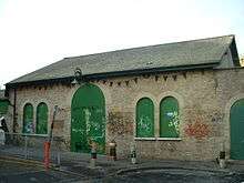
| Shoreditch (now replaced by Shoreditch High Street) | 10 April 1876 | 31 March 1913 | Closed on 9 June 2006, prior to whole line's temporary closure for conversion to Overground. |
| Whitechapel | 10 April 1876 | 31 March 1913 | Interchange with District and Hammersmith & City Lines. |
| Shadwell | 10 April 1876 | 1 October 1884 | Interchange with Docklands Light Railway. |
| Wapping | 7 December 1869 | 1 October 1884 | Thames Tunnel link to Rotherhithe |
| Rotherhithe | 7 December 1869 | 1 October 1884 | Thames Tunnel link to Wapping |
| Canada Water | 19 August 1999 | 19 August 1999 | Interchange with Jubilee line opened 17 September 1999. |
| Surrey Quays | 7 December 1869 | 1 October 1884 | Station was opened as Deptford Road, renamed Surrey Docks in 1911, and again renamed in 1989. |
| line splits | |||
| New Cross Gate | 7 December 1869 | 1 October 1884 | Interchange with Southern mainline services. Mainline station was opened as New Cross in 1839, and renamed in 1923. |
| New Cross | 1 April 1880 | 1 October 1884 | Interchange with Southeastern mainline services. Mainline station was opened in 1850. |
Conversion to Overground
Engineering work on the East London line extension started in 2005 and the underground service ended in December 2007.
In 2007 London Buses route ELW Whitechapel - Shadwell - Wapping was introduced, operating every 10 minutes, every 15 minutes at evenings and weekends.[18] It was operated with route-branded single-deck buses. Starting on 23 December 2007 it was extended from Whitechapel to Shoreditch (Monday-Friday 0700-1030 & 1530-2030, Sunday 0700-1530) from 19 July 2008. The frequency of the route was cut to four buses per hour in September 2009.[19] It was reduced to weekends-only from 28 April 2010, and withdrawn on 9 May 2010.
Between 2006 and May 2008 other rail replacement buses were provided. Route ELS Whitechapel - Shoreditch (Monday-Friday 0700-1030 & 1530-2030, Sunday 0700-1530) commenced 10 June 2006 and was withdrawn on 19 July 2008. It was replaced by a peak-hour extension of route ELW.
London Buses route ELC New Cross Gate - New Cross - Surrey Quays - Canada Water (Monday-Friday every 5–10 minutes, weekends every 15 minutes)[18] started on 23 December 2007. It was withdrawn on 25 September 2009 following a 40% drop in passenger numbers. Transport for London estimated that this saved around £1 million over the period to June 2010.[20]
London Buses route ELP Canada Water - Rotherhithe (every 15 minutes) began on 23 December 2007 and was withdrawn on 24 February 2008 due to lack of use: tickets were valid between Bermondsey and Canada Water on standard route 381.[18]
Unlike the previous East London Line closure, no replacement bus service was provided across the River Thames through the Rotherhithe Tunnel. London Transport was concerned that demand would be so high and buses would be so small that the frequency could have to be one bus every 30 seconds. There was also an issue that the Rotherhithe Tunnel is restricted to vehicles with a width no more than 7 feet (2.1 m), which had been employed on previous occasions. However, by 2007 no such vehicles were commercially available that were low-floor compliant: the only ones with this width, as previously used, were minibuses with higher floors. As bus policy by this time was 100% low floor, it meant that no such service could be provided.
A limited train service was introduced on 27 April 2010 and full service began on 23 May 2010.[21]
History of the extended route
Mostly on viaduct, the route from Highbury and Islington to Shoreditch was opened in 1865. It was constructed by the North London Railway as its city branch to allow its passenger trains to reach the City of London. As originally built the line had four stations, at Dalston Junction, Haggerston, Shoreditch and a large terminus at Broad Street. At Dalston Junction, a line branched to the North London Line eastwards, allowing services to Stratford and Poplar. This route closed to passengers in 1944.
At its peak, Broad Street was the third-busiest station in London (after Liverpool Street and Victoria). At the start of the 20th century, more than one train per minute arrived or departed Broad Street during rush hour, with over 27 million passengers in 1902. Intermediate station traffic stagnated due to bus and tram competition, and Haggerston and Shoreditch stations were closed in 1940 following bomb damage in the World War II. The line remained busy up to the 1950s, receiving traffic from the East Coast main line, West Coast main line and other routes. However, it declined following the war and was closed in 1986. While Broad Street station's site was immediately sold for office use, becoming the Broadgate development, the route north was mothballed. The present Haggerston and Dalston Junction stations have been built next to and on the original sites, but Shoreditch High Street station is on a new alignment connecting the two routes.
Extension
Phase 1
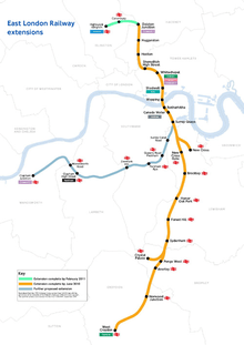
The former line was extended northwards from Whitechapel, with new stations at Shoreditch High Street, Hoxton, Haggerston and Dalston Junction using 2.2 miles (3.5 km) of new trackbed between Whitechapel and the Broad Street viaduct and disused trackbed for most of the distance. A further extension to Highbury & Islington was opened in February 2011.
It was extended south to connect to the London Bridge arm of the Brighton Main Line, linked via a northbound flyover north of New Cross Gate. Other than the new flyover and some associated works around New Cross Gate, it uses almost entirely existing track, running south to West Croydon via Brockley, Honor Oak Park, Forest Hill, Sydenham, Penge West, Crystal Palace (by way of a branch), Anerley and Norwood Junction.
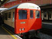
The official opening of most of phase 1 of the East London line extension took place on 23 May 2010.[22] Use of the line is forecast to increase from the previous 10.4 million passengers per year to 35.4 million, and to 50 million when phase 2 is finished.[23] Transport for London acquired 20 new four-car Class 378 Bombardier Capitalstar electric multiple units to operate on the line. Unlike the dual-voltage 378s on the North and West London Lines, the East London Line units can only receive power from the third rail electrification, although, like all modern EMUs, they have the potential to be retro-fitted.
The track and the northern extension remain under TfL ownership, and the stations from Dalston Junction to Surrey Quays are part of the London Overground network.[24] The extension runs northwards from Whitechapel to Dalston Junction, and south to Crystal Palace and West Croydon.
Highbury & Islington extension
| London Overground | |||||||||||||||||||||||||||||||||||||||||||||||||||||||||||||||||||||||||||||||||||||||||||||||||||||||||||||||||||||||||||||||||||||||||||||||||||||||||||||||
|---|---|---|---|---|---|---|---|---|---|---|---|---|---|---|---|---|---|---|---|---|---|---|---|---|---|---|---|---|---|---|---|---|---|---|---|---|---|---|---|---|---|---|---|---|---|---|---|---|---|---|---|---|---|---|---|---|---|---|---|---|---|---|---|---|---|---|---|---|---|---|---|---|---|---|---|---|---|---|---|---|---|---|---|---|---|---|---|---|---|---|---|---|---|---|---|---|---|---|---|---|---|---|---|---|---|---|---|---|---|---|---|---|---|---|---|---|---|---|---|---|---|---|---|---|---|---|---|---|---|---|---|---|---|---|---|---|---|---|---|---|---|---|---|---|---|---|---|---|---|---|---|---|---|---|---|---|---|---|---|
Legend | |||||||||||||||||||||||||||||||||||||||||||||||||||||||||||||||||||||||||||||||||||||||||||||||||||||||||||||||||||||||||||||||||||||||||||||||||||||||||||||||
| |||||||||||||||||||||||||||||||||||||||||||||||||||||||||||||||||||||||||||||||||||||||||||||||||||||||||||||||||||||||||||||||||||||||||||||||||||||||||||||||
The line was extended northwards to Highbury & Islington on 28 February 2011,[25] two months earlier than previously announced, with eight trains per hour during most of the day. The first train, with headcode 9A20, was the 09:55 Highbury & Islington - Crystal Palace, which departed on time from platform 2 and was formed of a four-car class 378 unit.
East London line extension phase 2
A further 6.7 miles (10.8 km) link opened in 2012 from south of Surrey Quays via the Network Rail South London Line to Clapham Junction via Queens Road Peckham, Peckham Rye, Denmark Hill, Clapham High Street and Wandsworth Road. A new station at Surrey Canal Road was also planned, but this was put on hold in 2009,[26] though a suitable 'box' is being provided as part of the works to facilitate later implementation. The service from Highbury & Islington to Clapham Junction commenced on 9 December 2012.[8] There are one or two services per day that run from Wandsworth Road to Battersea Park to maintain a service along that route as a parliamentary train.
The extension uses an alignment between Surrey Quays and Queens Road Peckham stations that had not seen services since 1913. The "new" section diverges from the East London Line south of Surrey Quays station and joins the South London Line just north of the closed Old Kent Road station. The route skirts the Bridgehouse Meadows public open space; this was used as the construction site, restored to public use after completion. The former pedestrian bridge and support piers over Surrey Canal Road were demolished as a precursor to building the railway bridge. The planned lowering of Surrey Canal Road and associated work to the services were not carried out as a higher elevation was adopted, with a 1 in 30 (3.3 per cent) incline allowing the railway to cross at a suitable height.
Future
To cope with increased demand, the class 378 units which operate on the line are being extended to five cars. Although the new stations on the line have platforms which are either at least five cars long or provide space for platform extensions, some stations cannot be extended and so selective door opening is required.
Gallery
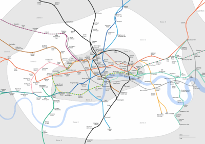 Map of zones 1 and 2 of the Underground, showing the East London line (towards the right-hand side of the map)
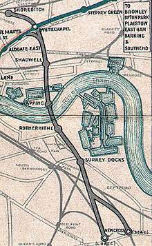
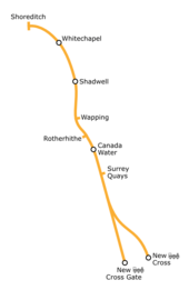 Map showing the London Underground East London line
References
- ↑ "London Overground". Transport for London. Retrieved 7 October 2016.
- ↑ "East London Line officially opened by Boris Johnson". BBC News Online. London. 27 April 2010. Retrieved 27 April 2010.
- ↑ Clarke, Megan (21 April 2010). "Party Time for East London Line". London Evening Standard. Retrieved 23 April 2010.
- ↑ "East London Line alternative transport strategy update" (PDF). London Underground. 27 November 2006. Archived from the original (PDF) on September 28, 2007. Retrieved 24 December 2006.
- 1 2 3 4 East London line facts, Transport for London.
- ↑ "First train runs on East London Railway". Railnews. Stevenage. 8 October 2009. Retrieved 8 October 2009.
- ↑ http://www.tfl.gov.uk/corporate/projectsandschemes/15401.aspx[]
- 1 2 "Outer London rail orbital opens for passengers". BBC. 10 December 2012. Retrieved 15 December 2012.
- ↑ McCarthy, Colin; McCarthy, David (2009). Railways of Britain – London North of the Thames. Hersham, Surrey: Ian Allan Publishing. pp. 14–15. ISBN 978-0-7110-3346-7.
- ↑ Brunel's Thames Tunnel Today, BBC News, 22 November 2008.
- ↑ "Railway And Other Companies, East London". The Times. London. 2 September 1869.
- ↑ Beaumont, Martin (2015). Sir John Hawkshaw 1811-1891. The Lancashire & Yorkshire Railway Society www.lyrs.org.uk. p. 68-69, 108-111. ISBN 978-0-9559467-7-6.
- 1 2 3 Rose, Douglas (December 2007) [1980]. The London Underground: A Diagrammatic History (8th ed.). Harrow Weald: Capital Transport. ISBN 978-1-85414-315-0.
- ↑ Gordon, W.J. (1910). Our Home Railways (volume one). London: Frederick Warne. p. 153.
- ↑ Klapper, Charles (1976). London's Lost Railways. London: Routledge and Kegan Paul. pp. 94–98. ISBN 0-7100-8378-5.
- ↑ , 1933 Beck map.
- ↑ "Illegal subway strike called off in London". Globe & Mail. Toronto. 21 May 1985.
- 1 2 3 "All change on the East London line", BBC London.
- ↑ "Changes to East London line replacement buses" (Press release). Transport for London. 21 September 2009.
- ↑ The London Assembly: Bus cuts
- ↑ "Full service begins on newly extended East London Line". BBC News Online. London. 23 May 2010. Retrieved 23 May 2010.
- ↑ Crerar, Pippa (27 April 2010). "East London line's opening puts Hackney on rail map". London Evening Standard. Retrieved 26 August 2010.
- ↑ "London takes over responsibility for building East London line extension" (Press release). Greater London Authority. 16 November 2004.
- ↑ London Overground signs standard.
- ↑ "Highbury & Islington extension in May 2011". Transport for London.
- ↑ McKenna, John (12 February 2009). "East London Line extension to Clapham to be built by London 2012". New Civil Engineer. Retrieved 16 February 2009.
Various sources have been used in the creation of this article, including the external links below, email conversations with the ELL Project Team and emails from the ELL Project Team update newsletter.
Further reading
- Wayne Asher. 2015. A Very Political Railway - the rescue of the North London Line. ISBN 978-1-85414-378-5
- John Glover. 2013. London's Overground. ISBN 978-0-7110-3524-9
External links
| Wikimedia Commons has media related to East London Line. |
- East London line - London Underground website
- East London line Project (official home page)
- East London line extensions map
- Official suspension notice
- Video Flyover of Phase 1
- Photos of the East London Line and Thames Tunnel while still London Underground
| |||||||||||||||||||||||||||||||||
| |||||||||||||||||||||||||||||||||
| Main Lines |
|  | ||||||
|---|---|---|---|---|---|---|---|---|
| Branch |
| |||||||
| Disused |
| |||||||