West Hampstead

Coordinates: 51°33′15″N 0°11′20″W / 51.5543°N 0.1888°W
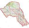
West Hampstead is an area in the London Borough of Camden in north-west London. Mainly defined by the railway stations of the same name, it is situated between Childs Hill to the north, Frognal and Hampstead to the north-east, Swiss Cottage to the east, South Hampstead to the south-east, Kilburn to the west and south-west, and Cricklewood to the north-west. The area is mainly residential with several small shops, restaurants, cafes, bakeries concentrated on the northern section of West End Lane and around West End Green. It is served by three stations: West Hampstead on the Jubilee line, West Hampstead Overground station and West Hampstead Thameslink station.
History

The village of West End
An area, known as "le Rudyng" (indicating a woodland clearing) in the mid-13th century, had by 1534 come to be called West End. It was then a freehold estate belonging to Kilburn Priory, and was so called because it was at the west end of another, larger estate. Although it is possible that there was a dwelling on the estate prior to 1244, an estate house was certainly extant by 1646.[1] West End Lane (named as such by 1644) is still bent at a right-angle at the north and south ends where it connects to Finchley Road and Edgware Road respectively. This is because the lane used to form the boundary between a number of different estates.[1]
By the early 17th century a number of houses were present, and by the middle of that century London merchants were building larger houses in the area, so turning a hamlet into the village of West End.[1]
West Hampstead
At the beginning of the 19th century, there were three main large houses around the hamlet of West End: West End House, West End Hall and Lauriston Lodge which were later sold off for redevelopment with the arrival of the railways, which led to the transformation of the area from farmland into housing estates.[2] In 1879, the Metropolitan Railway adopted the name West Hampstead for its station on West End Lane, the main road through the area.[1]
Notable buildings and sites
- Hampstead Cemetery on Fortune Green Road, opened in 1876[3]
- Hampstead Synagogue on Dennington Park Road, built on the site of Lauriston Lodge, opened in 1892.
- Emmanuel Church, West Hampstead on the corner of Lyncroft Gardens, opened in 1903.
- West Hampstead Fire Station was opened in 1901[1] and is still operating, responding to over two thousand emergency calls a year. Its service area covers 12 square miles (31 km2), including Hampstead, West Hampstead, Kilburn, Cricklewood and parts of Golders Green.
- Hampstead Cricket Club moved to Lymington Road in 1877.
- Decca Studios on Broadhurst Gardens. Now used as rehearsal space by the English National Opera. David Bowie recorded his first single and the Rolling Stones their first album in the studios. They were also known for being where the Beatles failed their audition with Decca Records on 1 January 1962, before they signed with Parlophone.
Transport links
| Stations in West Hampstead | |||||||||||||||||||||||||||||||||||||||||||||||||||||||||||||||||||||||||||||||||||||||||||||||||||||||||||||||||||||||||||||||||||||||||
|---|---|---|---|---|---|---|---|---|---|---|---|---|---|---|---|---|---|---|---|---|---|---|---|---|---|---|---|---|---|---|---|---|---|---|---|---|---|---|---|---|---|---|---|---|---|---|---|---|---|---|---|---|---|---|---|---|---|---|---|---|---|---|---|---|---|---|---|---|---|---|---|---|---|---|---|---|---|---|---|---|---|---|---|---|---|---|---|---|---|---|---|---|---|---|---|---|---|---|---|---|---|---|---|---|---|---|---|---|---|---|---|---|---|---|---|---|---|---|---|---|---|---|---|---|---|---|---|---|---|---|---|---|---|---|---|---|---|
| |||||||||||||||||||||||||||||||||||||||||||||||||||||||||||||||||||||||||||||||||||||||||||||||||||||||||||||||||||||||||||||||||||||||||
There are three railway stations named West Hampstead all within close proximity, as well as a number of other tube stations in the area. Numerous bus routes also pass through the district.
- Tube: West Hampstead tube station, on the Jubilee line. Nearby is Finchley Road tube station, on the Jubilee and Metropolitan lines.
- Trains: West Hampstead Thameslink station on the cross London Thameslink route, and West Hampstead Overground station on the North London Line.
- Buses: 139 (West Hampstead to Waterloo via Oxford Street, 24 hours), 328 (Golders Green to Chelsea via Notting Hill), and C11 (Brent Cross Shopping Centre to Archway via Hampstead Heath).
West Hampstead signal box
The power signal box (PSB) for the northern end of the Thameslink route is in Iverson Road, West Hampstead, around the corner from the Thameslink station. The Network Rail signal box can be seen from the north end of the platforms on the left. As well as being a 24 hours a day, 7 days a week operational building, it also houses engineers and acts as a base for Mobile Operation Managers (MOMs). The upper floor of this box controls the signals and operation of the railway from Farringdon/St Pancras International as far as Sharnbrook (just north of Bedford Station). Before the demise of First Capital Connect (FCC), also located in the box (in the same room as the signalling panels) was FCC's Thameslink control (also known to staff as the Service Delivery Centre or SDC). FCC's services between London Blackfriars and Bedford were controlled from here. South of Blackfriars, FCC trains were either controlled by southeastern control (to Sevenoaks) or FCC's other SDC at Croydon (for services to Brighton and Sutton/Wimbledon). Information on the service status of the line, including the operation of the information screens, was also controlled from here. East Midlands Trains do not have controllers at West Hampstead however.
Notable residents
There are four English Heritage blue plaques in West Hampstead commemorating the historic personalities that have lived there.[4] The plaques mark the residences of painter David Bomberg at 10 Fordwych Road, conductor Sir Adrian Boult at 78 Marlborough Mansions on Cannon Hill, newspaper proprietor Alfred Harmsworth, 1st Viscount Northcliffe at 31 Pandora Road, and ophthalmologist Dame Ida Mann at 13 Minster Road.[4]
Other notable people
- Gerry Anderson – publisher, producer, director and writer
- Joan Armatrading – singer and musician, lived here in her early days
- Camila Batmanghelidjh – businesswoman, charity leader and author
- Sacha Bennett – filmmaker
- Dirk Bogarde – actor
- Paul Brightwell - actor
- Jim Carter – actor
- Gus Dudgeon – record producer, lived at Kings Gardens and worked at Decca Studios in Broadhurst Gardens
- Marina Fiorato – author
- Stephen Fry – actor and television presenter
- Angela Griffin – actress and television presenter
- Margot Heinemann, British Marxist writer, leading member of the Communist Party of Great Britain (CPGB), born at 89 Priory Road[5]
- Chaka Khan – singer
- Phyllida Law - actress
- Doris Lessing – author
- Matt Lucas – comedian and actor
- Slash – guitarist for Velvet Revolver and former guitarist for Guns N' Roses
- Henry Spinetti – drummer, session musician and brother of the actor Victor Spinetti
- Dusty Springfield – singer, born here
- Imelda Staunton – actress
- Emma Thompson – actress, comedian and screenwriter
- Sophie Thompson – actress
- Johnny Vegas – actor, comedian
- Alec and Evelyn Waugh - authors, who grew up in Hillfield Road.
Gallery
 West End Green, near the northern end of West End Lane
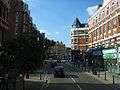 Shops on West End Lane
 Shops, Library on West End Lane
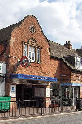 West Hampstead tube station
 West Hampstead London Overground station
 West Hampstead Thameslink station
References
- 1 2 3 4 5 C R Elrington (Editor), T F T Baker, Diane K Bolton, Patricia E C Croot (1989). A History of the County of Middlesex: Volume 9 - Hampstead, Paddington. pp. 42–47.
- ↑ The Streets of West Hamsptead, Camden History Society (1992).
- ↑ [Camden History Society: The Streets of West Hampstead, Camden History Society (1992)]
- 1 2 "Search Blue Plaques". Blue plaques search - West Hampstead. English Heritage. Retrieved 6 September 2014.
- ↑ H Gustav Klaus: "Heinemann, Margot Claire (1913–1992)", Oxford Dictionary of National Biography, Oxford University Press, 2004, accessed 5 May 2014
Location in context
 |
Cricklewood | Fortune Green | Childs Hill | |
| Kilburn | |
Hampstead | ||
| ||||
| | ||||
| St John's Wood | South Hampstead | Swiss Cottage |