Shoreditch
| Shoreditch | |
 Shoreditch Town Hall |
|
 Shoreditch |
|
| OS grid reference | TQ325825 |
|---|---|
| – Charing Cross | 2.5 mi (4.0 km) WSW |
| London borough | Hackney |
| Ceremonial county | Greater London |
| Region | London |
| Country | England |
| Sovereign state | United Kingdom |
| Post town | LONDON |
| Postcode district | E1, E2 |
| Postcode district | EC1, EC2 |
| Postcode district | N1 |
| Dialling code | 020 |
| Police | Metropolitan |
| Fire | London |
| Ambulance | London |
| EU Parliament | London |
| UK Parliament | Hackney South and Shoreditch |
| London Assembly | North East |
Coordinates: 51°31′34″N 0°04′41″W / 51.526°N 0.078°W
Shoreditch is an inner city district in the historic East End of London and modern Central London[1] within the London Borough of Hackney, lying immediately to the north of the City of London.
History
Etymology
The etymology of "Shoreditch" is debated. One legend holds that the place was originally named "Shore's Ditch", after Jane Shore, the mistress of Edward IV, who is supposed to have died or been buried in a ditch in the area. This legend is commemorated today by a large painting, at Haggerston Branch Library, of Jane Shore being retrieved from the ditch, and by a design on glazed tiles in a shop in Shoreditch High Street showing her meeting Edward IV.[2]
However, the area was known as "Soersditch" long before Jane Shore's life. A more plausible origin for the name is "Sewer Ditch", in reference to a drain or watercourse in what was once a boggy area.[3] It may have referred to the headwaters of the river Walbrook, which rose in the Curtain Road area.
Origins

Though now part of Inner London, Shoreditch was previously an extramural suburb of the City of London, centred on Shoreditch Church at the crossroads where Shoreditch High Street and Kingsland Road are crossed by Old Street and Hackney Road.
Shoreditch High Street and Kingsland road are a small sector of the Roman Ermine Street and modern A10. Known also as the Old North Road, it was a major coaching route to the north, exiting the City at Bishopsgate. The east–west course of Old Street–Hackney Road was also probably originally a Roman Road, connecting Silchester with Colchester, bypassing the City of London to the south.[4]
Shoreditch Church (dedicated to St Leonard) is of ancient origin and features in the famous line "when I grow rich say the bells of Shoreditch", from the nursery rhyme Oranges and Lemons.
Shoreditch was the site of a house of canonesses, the Augustinian Holywell Priory (named after a Holy Well on the site), from the 12th century until its dissolution in 1539. This priory was located between Shoreditch High Street and Curtain Road to east and west and Batemans Row and Holywell Lane to north and south. Nothing remains of it today.[5]
Elizabethan theatre

In 1576 James Burbage built the first playhouse in England, known as "The Theatre", on the site of the Priory (commemorated today by a plaque on Curtain Road, and excavated in 2008, by MoLAS).[6] Some of Shakespeare's plays were performed here and at the nearby Curtain Theatre, built the following year and 200 yards (183 m) to the south (marked by a commemorative plaque in Hewett Street off Curtain Road). It was here that Shakespeare's Romeo and Juliet gained "Curtain plaudits" and where Henry V was performed within "this wooden O". In 1599 Shakespeare's Company literally upped sticks and moved the timbers of "The Theatre" to Southwark at expiration of the lease to construct The Globe. The Curtain continued performing plays in Shoreditch until at least 1627.[7]
The suburb of Shoreditch was attractive as a location for these early theatres because it was outside the jurisdiction of the somewhat puritanical City fathers. Even so, they drew the wrath of contemporary moralists as did the local "base tenements and houses of unlawful and disorderly resort" and the "great number of dissolute, loose, and insolent people harboured in such and the like noisome and disorderly houses, as namely poor cottages, and habitations of beggars and people without trade, stables, inns, alehouses, taverns, garden-houses converted to dwellings, ordinaries, dicing houses, bowling alleys, and brothel houses".[8]
During the 17th century, wealthy traders and Huguenot silk weavers moved to the area, establishing a textile industry centred to the south around Spitalfields. By the 19th century Shoreditch was also the locus of the furniture industry, now commemorated in the Geffrye Museum on Kingsland Road. However the area declined along with both textile and furniture industries and by the end of the 19th century Shoreditch was a byword for crime, prostitution and poverty. This situation was not improved by extensive devastation of the housing stock in the Blitz during World War II and insensitive redevelopment in the post-war period.
Victorian entertainments


In the 19th and early 20th centuries Shoreditch was a centre of entertainment to rival the West End and boasted many theatres and music halls:
- The National Standard Theatre, 2/3/4 Shoreditch High Street (1837–1940). In the late 19th century this was one of the largest theatres in London. In 1926 it was converted into a cinema called The New Olympia Picturedrome. The building was demolished in 1940. Sims Reeves, Mrs Marriott and James Anderson all appeared here; also performed were programmes of classical opera and even Shakespeare, with such luminaries as Henry Irving. There was considerable rivalry with the West End theatres. John Douglass (the owner, from 1845) wrote a letter to The Era following a Drury Lane first night, in which he commented that "seeing that a hansom cab is used in the new drama at Drury Lane, I beg to state that a hansom cab, drawn by a live horse was used in my drama ... produced at the Standard Theatre ... with real rain, a real flood, and a real balloon."[9]
- The Shoreditch Empire aka The London Music Hall, 95–99 Shoreditch High Street (1856–1935). The theatre was rebuilt in 1894 by Frank Matcham. the architect of the Hackney Empire. Charlie Chaplin is recorded as performing here, in his early days, before he achieved fame in America.[10]
- The Royal Cambridge Music Hall, 136 Commercial Street (1864–1936), was destroyed by fire in 1896, then rebuilt in 1897 by Finch Hill, architect of the Britannia Theatre, in nearby Hoxton. The Builder of 4 December 1897 said "The New Cambridge Music Hall in Commercial Street, Bishopsgate, is now nearing completion. The stage will be 41 feet [12.5 m] wide by 30 feet [9.1 m] deep. The premises will be heated throughout by hot water coils, and provision has been made for lighting the house by electric light."
None of these places of entertainment survive today. For a brief time music hall was revived in Curtain Road by the temporary home of the Brick Lane Music Hall.[11] This too has now moved on.
A number of playbills and posters from these music halls survive in the collections of both the Bishopsgate Institute and the Victoria and Albert Museum.
Geography

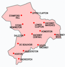
The historic heart of Shoreditch is Shoreditch High Street and Shoreditch Church. In the past the area of Shoreditch was defined by the borders of the parish of Shoreditch which later defined the borders of the Metropolitan Borough of Shoreditch. Since 1965, when the latter unit of local government was dissolved, it has been more fuzzily defined. Hoxton to the north of Old Street was historically part of Shoreditch parish and borough, and is still often conflated with it.
Administration
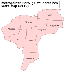
The medieval parish of Shoreditch (St Leonard's) was once part of the county of Middlesex but became part of the new County of London in 1889. The parish remained the local administrative unit until the creation of the Metropolitan Borough of Shoreditch in 1899. The Borough was made up of three districts – Shoreditch, Hoxton and Haggerston – and administered from Shoreditch Town Hall, which can still be seen on Old Street. It has been restored and is now run by the Shoreditch Town Hall Trust. Shoreditch was incorporated into the much larger London Borough of Hackney in 1965.
Contemporary culture
Shoreditch has, since around 1996, become a popular and fashionable part of London. Often conflated with neighbouring Hoxton, the area has been subject to considerable gentrification in the past twenty years, with accompanying rises in land and property prices.
More recently, during the second 'dot-com' boom, the area has become popular with London-based web technology companies who base their head offices around Old Street. These include Last.fm, Dopplr, Songkick, SocialGO and 7digital. These companies have tended to gravitate towards Old Street Roundabout, giving rise to the term "Silicon Roundabout" to describe the area, as used by Prime Minister David Cameron in a speech in November 2010.[12]
Formerly a predominantly working class area, Shoreditch and Hoxton have, in recent years, been gentrified by the creative industries and those who work in them. Former industrial buildings have been converted to offices and flats, while Curtain Road and Old Street are notable for their clubs and pubs which offer a variety of venues to rival those of the West End. Art galleries, bars, restaurants, media businesses and the building of the Hackney Community College campus are further features of this transformation.
In fact, the word Shoreditch is now synonymous with the concept of contemporary 'hipsterfication' of regenerated urban areas. As a pioneer among similar transformations across the UK, various phrases have been coined, from "Shoreditchification" to "Very Shoreditch".[13]
In September 2015 a demonstration against gentrification in London took the form of a protest at Cereal Killer Cafe a hipster café on Brick Lane which serves cereal.[14]
Reconstruction
South Shoreditch is currently undergoing an enormous transformation. Several five or six storey buildings have been knocked down in the area of Shoreditch which borders the City of London. In their place will be erected a variety of very tall buildings, mirroring the architectural styles in the City of London.[15] The building will result in more residential units being available for sale in Shoreditch than were produced by the Olympics athletes village.[15]

Notable local residents
- Andrew Weatherall, DJ, producer, and remixer
- Anissa Helou, cookbook author, teacher and chef specialising in the cuisines of the Mediterranean, Middle East and North Africa
- Barbara Windsor, comedian, film and television actress was born there.
- Christopher Marlowe, Elizabethan dramatist lived in Norton Folgate, the southern continuation of Shoreditch High Street, and wrote plays for the Shoreditch theatres.
- Damien Hirst, artist; instrumental in the development of the area's art scene in the early 1990s
- Emmanuel Ray, TV presenter/socialite
- Henry Hate, celebrity tattoo artist; clients include Boy George, Alexander McQueen, Amy Winehouse and Pete Doherty
- Hetty King, a famous male impersonator of the music hall, was born here. Her father, William Emms, was a local comedian known as William King.
- Hoxton Tom McCourt, influential in the late 1970s and early 1980s mod and oi/punk scenes and founder of the band, the 4-Skins, was born in Shoreditch in 1961.
- James Burbage, Tudor actor and impresario: built The Theatre; buried in Shoreditch church
- Jem Smith, bare knuckle prize fighter
- John Appold, FRS (1800–1865), a pioneer of the centrifugal pump
- Joshua Compston, curator & founder of Factual Nonsense; instrumental in the development of the area's art scene in the early 1990s; lived & died in Charlotte Road.
- Matt Monro, singer dubbed 'The singer's singer' and 'The British Sinatra', famous for singing the title songs of the films Born Free, From Russia with Love, and 'On Days Like These' from the film The Italian Job
- Miquita Oliver, T4 presenter
- Nat Wei, Baron Wei, youngest non-hereditary peer ever upon entry to the House of Lords and government advisor on Big Society
- Noel Fielding, comedian, film and television actor
- Richard Burbage, actor in the Lord Chamberlain's Men, Shakespeare's own Company. Renowned for his performance of Shakespeare's greatest roles: Hamlet, Richard III, etc. Buried in the church.
- Richard Tarleton, Elizabethan comedian. Shakespeare's Yorick is believed to be a homage to his memory. Buried in Shoreditch church.
- Russell Brand, actor and comedian
- Thomas Fairchild (gardener),the first person who succeeded in scientifically producing an artificial hybrid
- William James Blacklock, British landscape artist, was born in Shoreditch in 1816
- William Shakespeare, lodged in nearby Bishopsgate and wrote and performed plays for both The Theatre and Curtain Theatre.
- William Sommers, Henry VIII's jester; buried in Shoreditch church.
Education
Schools in the area include Hackney University Technical College, the first university technical college to be established in London.
Transport

- Reversion to two-way streets
In the mid-1960s, the main streets of Shoreditch (Old Street, Shoreditch High Street and Curtain Road, Great Eastern Street) were formed into a mile-long one-way system, which became associated with traffic congestion, poor conditions for walking and cycling, high speeds, high collision rates, and delays for bus services. The gyratory system came to be seen as "the main factor holding back the cultural regeneration of South Shoreditch"[16] and "a block to economic recovery".[17] Following a lengthy campaign,[18] the then newly formed Transport for London agreed to revert most of the streets to two-way working, a project which was completed in late 2002.
- Nearest stations
In 2005 funding was announced for the East London Line Extension which would extend the existing line from Whitechapel tube station bypassing Shoreditch tube station (which closed in June 2006) and creating a new station titled Shoreditch High Street at the site of the old Bishopsgate Goods Yard which was demolished in 2004.
The nearest stations served by the London Underground are Liverpool Street and Old Street.
- Disused stations
- Shoreditch railway station (closed 1940)
- Shoreditch tube station (closed 2006)
See also
- Curtain Road Arts
- East London Line
- Hackney College
- Hackney Community College Basketball Academy
- London United Basketball
- Nelson's Retreat Pub
- Shoreditch Park
References
- ↑ "London's Places" (PDF). London Plan. Greater London Authority. 2011. p. 46. Retrieved 27 May 2014.
- ↑ Clunn, H.P. (1970) The Face of London. Spring Books: London. pp. 312, 493
- ↑ Mander 1996, p. 13.
- ↑ Sugden n.d.
- ↑ Wood 2003.
- ↑ Shakespeare's Shoreditch theatre unearthed Maev Kennedy, The Guardian, Thursday, 7 August 2008
- ↑ Shapiro 2005.
- ↑ Middlesex Justices in 1596; cited in Schoenbaum 1987, p. 126.
- ↑ "Shoreditch Theatres and Halls". Arthur Lloyd. Retrieved 4 November 2016.
- ↑ "Shoreditch Empire" (PDF). Over the Footlights. Retrieved 4 November 2016.
- ↑ "Brick Lane Music Hall".
- ↑ Duncan Geere. "Transcript: David Cameron sets out Britain's hi-tech future". Wired.
- ↑ "Why this 'Shoreditchification' of London must stop".
- ↑ Feargus O'Sullivan (30 September 2015). "Breakfast of Gentrifiers How a London café that specializes in cereal became the latest flashpoint in the city's ongoing gentrification debate.". CityLab. Retrieved 30 September 2015.
When Londoners talk about regeneration, gentrification and the supposed cascade of bars, beards and real estate bubbles they bring in their wake, they typically talk about the café’s home neighborhood of Shoreditch.
- 1 2 "Three More Shoreditch Skyscraper Proposals". Londonist. Retrieved 2015-12-11.
- ↑ Teo Greenstraat of The Circus Space, quoted in More Light, More Power, No. 6, Autumn 2000
- ↑ Michael Pyner of Shoreditch New Deal Trust, quoted in More Light, More Power, No. 6, Autumn 2000
- ↑ The long road back to a two-way Shoreditch Hackney Cyclists, 2002
-
 This article incorporates text from a publication now in the public domain: Chisholm, Hugh, ed. (1911). "article name needed". Encyclopædia Britannica (11th ed.). Cambridge University Press.
 - Ackroyd, Peter (2000) London: The Biography. Chatto & Windus, London.
- Clifton, L. (2002) Baby Oil and Ice: Striptease in East London. The Do-Not Press Limited: London.
- Harrison, P. (1985) Inside the Inner City: Life Under the Cutting Edge. Penguin: Harmondsworth.
- Mander, David (1996). More Light, More Power: An Illustrated History of Shoreditch. Stroud: Sutton.
- Schoenbaum, S. (1987) William Shakespeare: a Compact Documentary Life, OUP.
- Shapiro, J. (2005) 1599: A Year in the Life of William Shakespeare. Faber and Faber, London.
- Sugden, K. (n.d.) Under Hackney: The Archaeological Story. FHA.
- Taylor, W. (2001) This Bright Field. Methuen: London.
- Wood, M (2003) In Search of Shakespeare. BBC Worldwide, London.
External links
| Wikimedia Commons has media related to Shoreditch. |
- A Tudor History of Shoreditch (from The National Archives)
- Shoreditch Town Hall
- Shoreditch Trust
- Shoreditch Spa Community Website
- The Shoreditch Map
 |
Hoxton | Dalston | Haggerston | |
| Old Street | |
Bethnal Green | ||
| ||||
| | ||||
| City of London | Bishopsgate | Spitalfields |
| Districts | 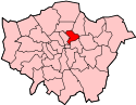 | |
|---|---|---|
| Attractions | ||
| Parks and open spaces | ||
| Street markets | ||
| Constituencies | ||
| Tube and rail stations | ||
| Other topics | ||