Edgware
| Edgware | |
 Aerial view of Edgware from Station Road; facing North towards Broadfields and Elstree. |
|
 Edgware |
|
| OS grid reference | TQ195925 |
|---|---|
| – Charing Cross | 10 mi (16 km) SE |
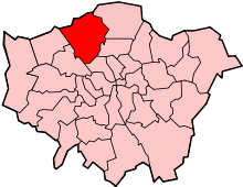
| London borough | Barnet |
| Ceremonial county | Greater London |
| Region | London |
| Country | England |
| Sovereign state | United Kingdom |
| Post town | EDGWARE |
| Postcode district | HA8 |
| Post town | LONDON |
| Postcode district | NW7 |
| Dialling code | 020 |
| Police | Metropolitan |
| Fire | London |
| Ambulance | London |
| EU Parliament | London |
| UK Parliament | Hendon |
| London Assembly | Barnet and Camden |
Coordinates: 51°37′07″N 0°16′22″W / 51.6185°N 0.2729°W
Edgware (/ˈɛdʒwɛər/) is a district of north London, in the London Borough of Barnet. Edgware is centred 10 miles (16 km) north-northwest of Charing Cross and has its own commercial centre. Edgware has a generally suburban character, typical of the rural-urban fringe. It was an ancient parish in the county of Middlesex. The community benefits from some elevated woodland on a high ridge marking the Hertfordshire border of gravel and sand. Edgware is identified in the London Plan as one of the capital's 35 major centres. In 2011, Edgware had a population of 76,056. Edgware is principally a shopping and residential area and one of the northern termini of the Northern line. It has a bus garage, a shopping centre called the Broadwalk, a library, a hospital—Edgware Community Hospital, and two streams—Edgware Brook and Deans Brook, both tributaries of a small brook known as Silk Stream, which in turn merges with the River Brent at Brent Reservoir.
History
| 1881 | 816 |
|---|---|
| 1891 | 864 |
| 1901 | 868 |
| 1911 | 1,233 |
| 1921 | 1,516 |
| Absorbed by Hendon parish ► | |
| source: UK census | |
Edgware succeeds to the identity of the ancient parish in the county of Middlesex. Edgware is a Saxon name meaning Ecgi's weir. Ecgi was a Saxon and the weir relates to a pond where Ecgi's people caught fish. Edgware parish formed part of Hendon Rural District from 1894.[1] It was abolished in 1931 and formed part of the Municipal Borough of Hendon until 1965.[2] The Romans made pottery at Brockley Hill, thought by some to be the site of Sulloniacis. Canons Park, to the north-west, was developed as an estate by James Brydges, 1st Duke of Chandos and was the site of his great palace Cannons.
Edgware was identified in 2008 as a major centre for preferred development in the London Plan.[3]
Demography and religion

Until the 20th century there were no major rises in the population of Edgware. In the manor of Edgware in 1277 there were eight free tenants (excluding the Grand Priory of Clerkenwell) and 52 customary tenants (assumed to all be men); the survey from which these figures are taken, however, includes lands appurtenant to the manor lying in Kingsbury. In 1425–26 the manor of Edgware had three free and 29 customary tenants in the parish, and in 1525–26 the numbers were two or three free and 26 customary tenants. In 1547 there were 120 (adult or teenage) communicants in the parish. In 1597 there were between 60 and 70 houses in the parish, and 44 more in the village of Edgware but on the west side of Watling Street and therefore in the parish of Little Stanmore. In 1599 there were six free and 25 customary tenants of the manor within Edgware. In 1642 in the Civil War the protestation oath of 1641 was taken by 103 adult males. In 1664 there were 73 houses in the parish, but the hearth tax of 1672 gives only 66. During the 18th century the average numbers both of baptisms and burials declined gently but steadily; in the period 1717–26 the average number of baptisms was between 15 and 16 a year and the average number of burials 20, but by 1801–10 the figures were 11 and 9, respectively. There were said to be 69 houses in the village in 1766 and 76 houses in 1792. At the first census in 1801 the population was 412. Throughout the 19th century numbers rose slowly, except for the years between 1851 and 1871; the censuses of 1861 and 1871 show successive declines of 7 percent, attributed in 1871 to migration and to the absence of direct trains to London.[4]
Ten years later the losses had been more than made good, and in 1901 the figure of 868 had been reached. By 1921 the population had grown to 1,516, but the great infilling of the southern part of Edgware after 1924 caused the most spectacular increase. In 1931 the population was 5,352; this had increased to 17,513 by 1951 and to 20,127 by 1961.[4] As well as Christian and subsequent settling of other religious groups, Edgware's development coincided with that of its Jewish community,[5] currently forming the largest single religious group.[6] In the 2001 Census, 36% of Edgware residents give their religion as Jewish, 28% Christian, 9% Hindu and 5% Muslim.[7] The Jewish community in Edgware has constructed its own Eruv.[8]
According to the 2011 census:
- Edgware ward of Barnet was 60% white (47% British, 12% Other White, 1% Irish). 13% was Indian and 7% Black African. 33% of the population was Jewish, 28% Christian and 11% Muslim.[9]
- Edgware ward of Harrow (south from the town centre) was 32% white (17% British, 15% Other). The largest single ethnic group was Indian (31%). 11% was Other Asian. 38% of the population wa Christian, 29% Hindu and 16% Muslim.[10]
- Hale ward of Barnet (east from the centre) was 59% white (45% British, 12% Other, 2% Irish) and 10% Indian. 39% was Christian and 19% Jewish.[11]
Economy
Argonaut Games once had its head office in Edgware.[12]
Transport


Tube
Stations in the area are:
- Edgware Station (Northern line)
- Burnt Oak tube station (Northern line)
- Colindale tube station (Northern line)
Buses
15 day London Buses serve Edgware, along with three night services, three school services, and two non-TfL routes operated by Uno.
Notable people
- Anita Asante footballer
- Eleanor Bron — actress
- Max Bygraves — singer, comedian and actor
- Antony Costa — singer from boy band Blue
- Charlotte McDonagh — actress/television presenter/model and singer
- Shirley Eaton — actress
- Vanessa Feltz — TV/radio presenter
- Dayan Michoel Fisher — Principal Rabbi of the Federation of Synagogues
- George Frideric Handel — composer
- Angharad Rees — actress
- Pat Sharp — disc jockey and television presenter
- Ben Strevens — footballer currently playing for Wycombe Wanderers
- Frank Williams — actor, most notable role: the vicar in Dad's Army
- John Bercow — current Speaker of the House of Commons and MP for Buckingham
- Nicolas Anelka — footballer, when playing for Arsenal
- Jane March — actress
- Mitchell Symons — journalist and author
- Barry Norman — television presenter and author
- Christopher Wreh — former Arsenal footballer
- Victor Feldman — jazz pianist
- Patrick Vieira — former Arsenal footballer
- Archie Panjabi — Emmy Award winning actress, currently portraying Kalinda Sharma on The Good Wife
- Altaf Hussain Chief and founder of Pakistan's MQM Party. Resident since 1992.
- Boz Boorer — Guitarist, producer, co-writer and musical director for Morrissey.
- Dave Mattacks — Rock and Folk drummer, best known for his work with Fairport Convention.
Education
- London Academy
- Beit Shvidler Primary School
- Holland House School
- Broadfields Primary School
- Deansbrook Primary School
- North London Collegiate School
- Rosh Pinah Primary School
- Edgware Junior School
- Canons High School
Geography
Edgware is a post town within the HA postcode area,.[13] It is also partly within the NW postcode area.
 |
Stanmore | Elstree | Borehamwood | |
| Queensbury | |
Mill Hill | ||
| ||||
| | ||||
| Kingsbury | Colindale | Hendon |
Gallery
 St Margaret of Antioch Church
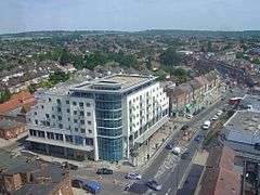
 Broadwalk Shopping Centre, located in the town centre. It was opened in the late 1980s.[14]
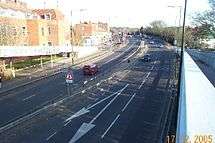 A41 Edgware Way, located north from Edgware town centre. View from Edgwarebury Lane footbridge.
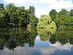 Basin Lake, located in Canons Drive to the west of Edgware. It is located in the borough of Harrow
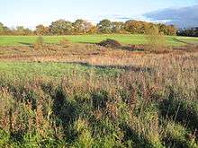 Grassland in Edgwarebury Park, taken from the A41 Edgware Way/Watford-by-Pass. This is the far north, rural area of Edgware.
 Former track of the Great Northern Railway line, which closed in 1964. View from Dean's Lane in the east of Edgware
 Rose Garden Close in western Edgware, near Canons Drive. This road consists of large suburban houses, near Lake Grove
 Premier Inn hotel, Edgware
References
- ↑ Vision of Britain - Hendon Rural District
- ↑ Vision of Britain - Edgware parish
- ↑ Mayor of London (February 2008). "London Plan (Consolidated with Alterations since 2004)" (PDF). Greater London Authority.
- 1 2 T F T Baker, J S Cockburn, R B Pugh (Editors), Diane K Bolton, H P F King, Gillian Wyld, D C Yaxley (1971). "Edgware: Introduction". A History of the County of Middlesex: Volume 4. Institute of Historical Research. Retrieved 5 November 2014.
- ↑ T F T Baker, J S Cockburn, R B Pugh (Editors), Diane K Bolton, H P F King, Gillian Wyld, D C Yaxley (1971). "Edgware: Jews". A History of the County of Middlesex: Volume 4. Institute of Historical Research. Retrieved 5 November 2014.
- ↑ Milmo, Cahal (3 August 2002). "Britain's first 'eruv' enclave for Jews divides local opinion". London: The Independent. Retrieved 2009-02-26.
- ↑ "see Barnet Census Profile" (PDF). Retrieved 2011-06-30.
- ↑ "The Edgware Eruv". The Edgware Eruv. 2006-10-17. Retrieved 2011-06-30.
- ↑ http://www.ukcensusdata.com/edgware-e05000050
- ↑ http://www.ukcensusdata.com/edgware-e05000287
- ↑ http://www.ukcensusdata.com/hale-e05000054
- ↑ "Argonaut Contact information". Argonaut Games. 13 January 1998. Archived from the original on 13 January 1998. Retrieved 9 November 2009. "Argonaut House 369 Burnt Oak Broadway Edgware Middlesex HA8 5XZ"
- ↑ Royal Mail, Address Management Guide (2004)
- ↑ http://www.thebroadwalkcentre.co.uk/Information/About-Us