Hackbridge
| Hackbridge | |
 Roofs of the BedZED zero energy homes |
|
 Hackbridge |
|
| OS grid reference | TQ285685 |
|---|---|
| London borough | Sutton |
| Ceremonial county | Greater London |
| Region | London |
| Country | England |
| Sovereign state | United Kingdom |
| Post town | WALLINGTON |
| Postcode district | SM6 |
| Dialling code | 020 |
| Police | Metropolitan |
| Fire | London |
| Ambulance | London |
| EU Parliament | London |
| UK Parliament | Carshalton and Wallington |
| London Assembly | Croydon and Sutton |
Coordinates: 51°24′03″N 0°09′06″W / 51.4009°N 0.1517°W
Hackbridge is a suburb in the London Borough of Sutton, south-west London, about two miles north east of the town of Sutton itself. It is 9 miles (15 km) south-west of Charing Cross.
Hackbridge Masterplan
The London Borough of Sutton is working to make Hackbridge the "UK's first truly sustainable suburb". There has been a regeneration scheme in Hackbridge which has a number of developments on many sites. These are mentioned as part of the Hackbridge Regeneration. Detailed plans include proposals for new eco-friendly homes, more shops, leisure and community facilities, jobs, sustainable transport and pedestrian/cycle initiatives, improved networks and open spaces.[1]
A key part of this is a £150m plan to redevelop the one million square foot former Felnex industrial estate, which has now gained redevelopment approval from the Greater London Authority. The development, described as "one of the greenest places to live in the UK", is to be centred on a public square and will see 725 homes built, as well as a new supermarket, doctor's surgery, care home, offices and workshops, additional shops and a bus interchange. Work was expected to begin as soon as detailed consent was obtained for the first phase, which was expected to be in early 2013.[2]
BedZED

Hackbridge has already achieved success in its green agenda in the form of the BedZED (Beddington Zero Energy Development) eco-friendly housing development, around 500 yards north of Hackbridge railway station. Designed to create zero carbon emissions, it was the first large scale community to do so.[3] BedZED utilises a number of innovative technologies to enable it to operate with zero energy use. It has attracted wide interest over the past decade since it was built, and, among other examples of recognition, it was shortlisted for the Stirling Prize for architecture in 2003. Key features of BedZED include:
- Zero energy—The project is designed to use only energy from renewable sources generated on site. There are 777 square metres (8,360 sq ft) of solar panels.
- High quality—The apartments are finished to a high standard to attract the urban professional.
- Energy efficient—The houses face south to take advantage of solar gain, are triple glazed, and have high thermal insulation.
- Water efficient—Most rain water falling on the site is collected and reused.
Geography


- Location
Hackbridge is located on the River Wandle in the London Borough of Sutton, about two miles north east of the town of Sutton itself.
- Architecture
Hackbridge has a fairly wide range of architecture, but is mainly Edwardian and early 20th century in the central shopping area with surrounding suburbs in Tudorbethan semi-detached style - a number of Post War Modernist social housing schemes have been demolished in recent years.[4]
There are also a number of 21st century buildings, the most notable being the environmentally-friendly BedZED development (see above); but a further example is the large and just completed (in 2013) Centrale apartment building (see photo) located in London Road, opposite the railway station. The former Durand Close Council estate is also being regenerated as a mixed tenure development[5] by the Lavender Housing Partnership over the period 2003-2018.[6]
- Churches
The parish church of Hackbridge and Beddington Corner was built in 1931 (see photo of interior). The architect was H.P. Burke-Downing, and it is located opposite BedZED on the London Road.
- Open Space
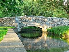
Beddington Park, through which the River Wandle flows, is a quarter of a mile (400 metres) south of Hackbridge railway station. It is nearly 100 acres (40 hectares) in size and is maintained by the London Borough of Sutton. It was originally part of the Deer Park attached to Carew Manor, a grand country house built in the Tudor period, which stands to this day. It is a large area of open grassland with small clumps of trees, with an area of more formal gardens near the Grange restaurant, as well as the lake and pond. The main lake in the south west of the park was originally a mill pond. There are many paths and a number of ornamental bridges (see photo), which cross the stream which feeds the lake: this is part of the River Wandle (a Thames tributary), and the park is on the Wandle Trail. Part of the park is managed as a wildlife site.
 |
Morden | Mitcham | Thornton Heath | |
| The Wrythe, St. Helier | |
Croydon | ||
| ||||
| | ||||
| Carshalton, Sutton | Wallington | Beddington |
Sport
Nearest professional football club:
Nearest league football club:
- Carshalton Athletic play approximately 0.5 miles away from Hackbridge.
- Sutton United also play very locally to Hackbridge.
Education
Primary education
- Culvers House Primary School
- Hackbridge Primary School
Famous past residents
- Tracey Ullman grew up in Hackbridge.[7]
- Tony Power: Songwriter[8]
Transport
- Rail
Hackbridge has a railway station with trains to London Victoria, London Blackfriars, Sutton, Wimbledon, London St Pancras, St Albans and Luton. Trains are operated by Thameslink and Southern. The station is in Travel Card Zone 4 and the journey time to London Victoria is 25 minutes.
- Bus
Hackbridge is served by Transport for London bus routes: 80, 127 and 151.[9]
- Tram
The nearest Tram stop to Hackbridge is at Mitcham Junction. Trams go to Wimbledon and Croydon.
Dogs' Home
Hackbridge was home to the first country dogs' home{ opened by the Duke and Duchess of Portland.
External links
- Hackbridge Network - Local community website for the Hackbridge neighbourhood
- Hackbridge Safety First - campaign to make Hackbridge a safer place since the redevelopment of Hackbridge
References
- ↑ London Borough of Sutton: Hackbridge Masterplan
- ↑ Sutton Guardian 7 June 2012
- ↑ Hyde, Richard; Watson, Steve; Cheshire, Wendy; Thompson, Mark (2007), The Environmental Brief: Pathways for Green Design, Taylor and Francis, p. 44, ISBN 978-0-203-96681-5
- ↑ Sutton Guardian
- ↑ Pollard Thomas Edwards
- ↑ Lavender Housing
- ↑ "The Paley Center for Media | She Made It | Tracey Ullman". She Made It. 30 December 1959. Retrieved 17 March 2014.
- ↑ Your local Guardian
- ↑ "Buses from Hackbridge" (PDF). TfL. Retrieved 17 March 2014.
| Districts |
|  |
|---|---|---|
| Attractions | ||
| Parks and open spaces | ||
| Constituencies | ||
| Rail and tram stations | ||
| Other topics | ||