Cook Township, Westmoreland County, Pennsylvania
| Cook Township, Pennsylvania | |
|---|---|
| Township | |
|
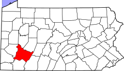
Family cabin at Linn Run State Park | |
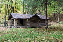
 Map of Westmoreland County, Pennsylvania Highlighting Cook Township | |
 Map of Pennsylvania highlighting Westmoreland County | |
| Country | United States |
| State | Pennsylvania |
| County | Westmoreland |
| Settled | 1809 |
| Incorporated | 1855 |
| Area | |
| • Total | 47.3 sq mi (123 km2) |
| Population (2000) | |
| • Total | 2,403 |
| • Density | 50.8/sq mi (19.6/km2) |
| Time zone | Eastern (EST) (UTC-5) |
| • Summer (DST) | EDT (UTC-4) |
| Website | http://www.cooktwp.com |
Cook Township is a township in Westmoreland County, Pennsylvania, United States. The population was 2,403 at the 2000 census.
History
The Linn Run State Park Family Cabin District was listed on the National Register of Historic Places in 1987.[1]
Geography
According to the United States Census Bureau, the township has a total area of 47.3 square miles (123 km2), of which, 47.3 square miles (123 km2) of it is land and 0.04 square miles (0.10 km2) of it (0.04%) is water.
The township contains the following boroughs and villages: Mansville, Pleasant Grove, Rectors Mill, Stahlstown, and Weaver Mill.
Demographics
As of the census[2] of 2000, there were 2,403 people, 927 households, and 716 families residing in the township. The population density was 50.8 people per square mile (19.6/km²). There were 1,181 housing units at an average density of 25.0/sq mi (9.6/km²). The racial makeup of the township was 99.79% White, 0.08% Asian, 0.04% from other races, and 0.08% from two or more races. Hispanic or Latino of any race were 0.21% of the population.
There were 927 households out of which 30.9% had children under the age of 18 living with them, 69.0% were married couples living together, 5.5% had a female householder with no husband present, and 22.7% were non-families. 19.7% of all households were made up of individuals and 8.4% had someone living alone who was 65 years of age or older. The average household size was 2.57 and the average family size was 2.96.
In the township the population was spread out with 22.2% under the age of 18, 7.4% from 18 to 24, 28.4% from 25 to 44, 28.6% from 45 to 64, and 13.3% who were 65 years of age or older. The median age was 41 years. For every 100 females there were 100.8 males. For every 100 females age 18 and over, there were 100.9 males.
The median income for a household in the township was $39,205, and the median income for a family was $46,336. Males had a median income of $29,154 versus $25,341 for females. The per capita income for the township was $18,547. About 3.1% of families and 6.4% of the population were below the poverty line, including 5.9% of those under age 18 and 9.8% of those age 65 or over.
References
- ↑ National Park Service (2010-07-09). "National Register Information System". National Register of Historic Places. National Park Service.
- ↑ "American FactFinder". United States Census Bureau. Archived from the original on 2013-09-11. Retrieved 2008-01-31.
| Counties |  Map of the Pittsburgh Tri-State with green counties in the metropolitan area and yellow counties in the combined area. | |
|---|---|---|
| Major cities | ||
| Cities and towns 15k-50k (in 2010) | ||
| Airports | ||
| Topics | ||
| ||
Coordinates: 40°07′00″N 79°15′59″W / 40.11667°N 79.26639°W